
September 27 2023 Pile Burn Update
Related Incident: Lolo National Forest Prescribed Fire Operations
Publication Type: Announcement
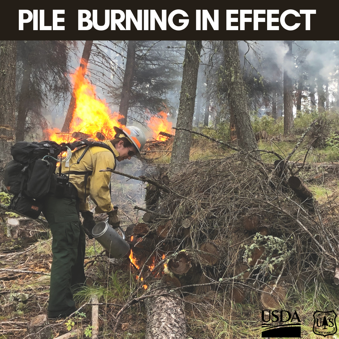
Pending conditions, pile burning will take place today on the Seeley and Missoula Ranger Districts to reduce hazardous fuels from previous vegetation management operations.
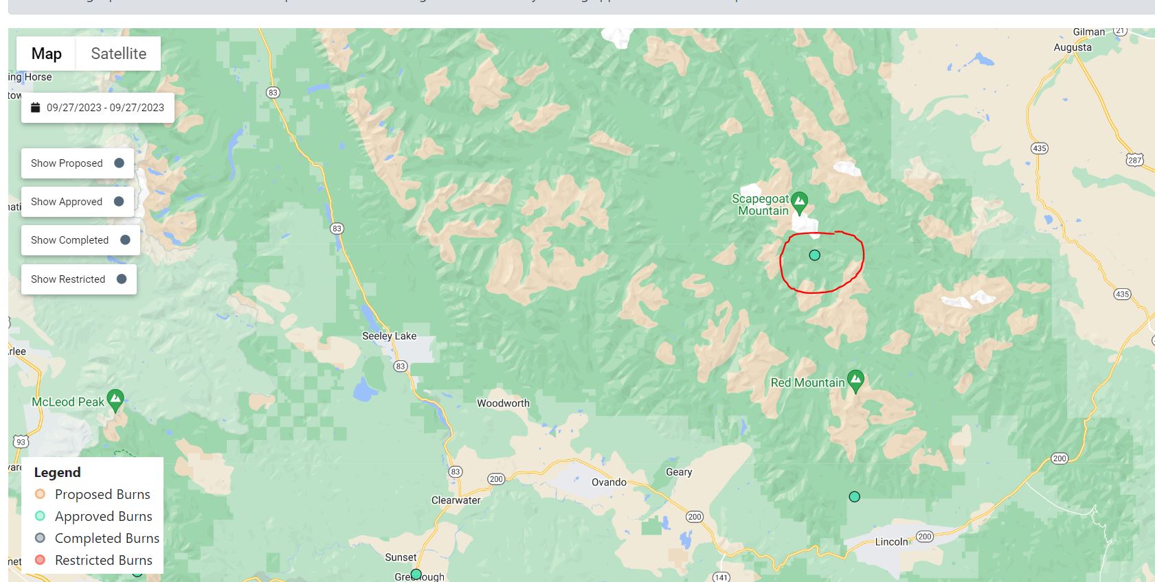
Seeley Ranger District:
Firefighters will conduct up to 2 acres of hand pile burning 17 miles up the North Fork of the Blackfoot River. Smoke may be visible from Highway 200 and Ovando. Hand ignitions will take less than one day to complete and firefighters will monitor and patrol the burn over the next few days.
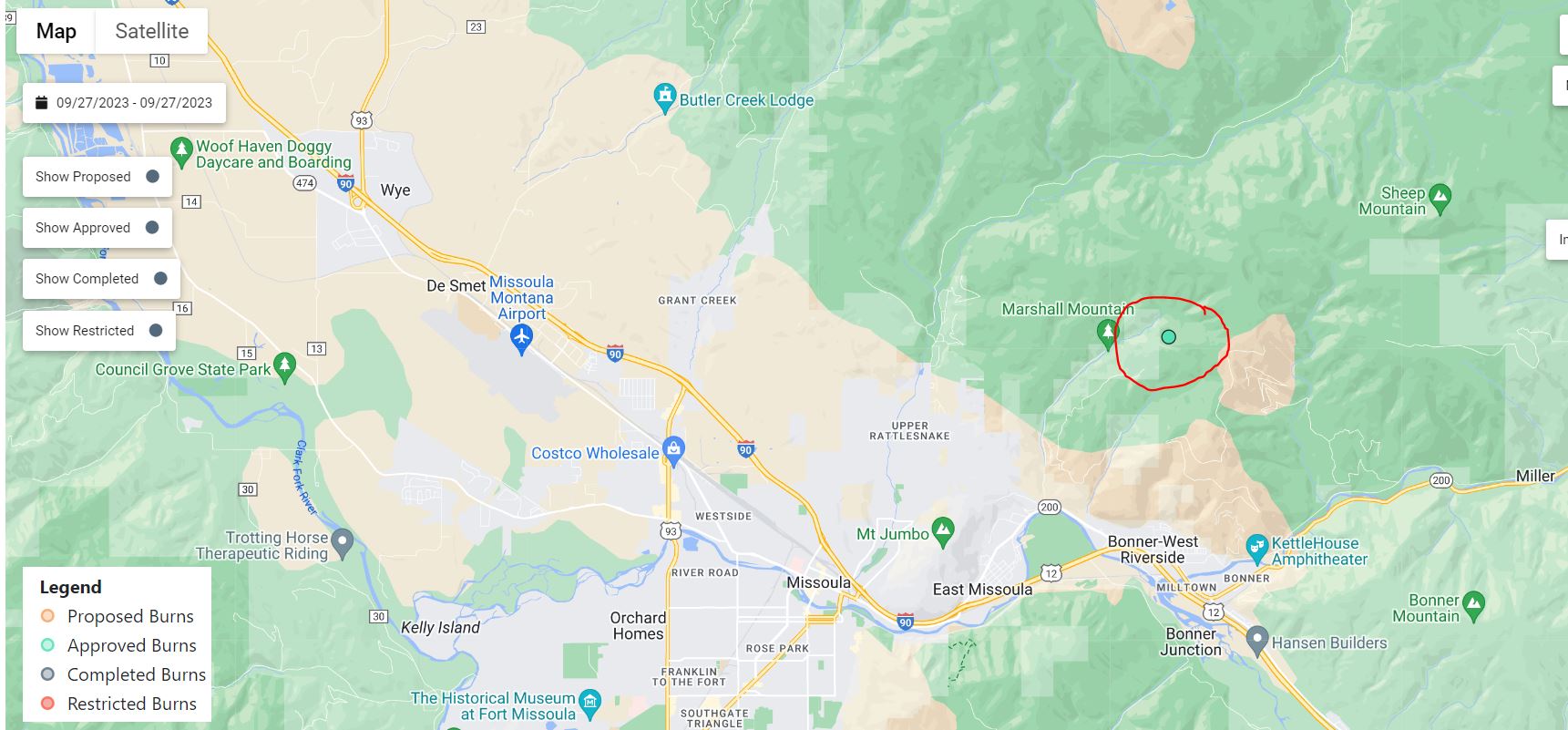
Missoula Ranger District:
Firefighters will conduct up to 20 acres of hand pile burning to reduce material left over from previous management operations. The pile burning operation is located in the Marshall Canyon area approximately 3 miles northwest of Missoula, MT. Smoke may be visible from the Rattlesnake, Missoula, Bonner and parts of the I-90 corridor. Firefighters will implement, patrol and monitor the pile burning over the next few days.

Smoke Activity From Nearby Prescribed Fire
Related Incident:
Publication Type: News
Smoke in the area is from a nearby prescribed fire on the Santa Fe National Forest. Stay updated with information on the Golondrino Prescribed Fire at New Mexico Fire Information.
Implementation of the the Montoya and Blas units of the Canjilon Wildland Urban Interface Project have not begun. An announcement will be made on InciWeb when potential dates are identified.
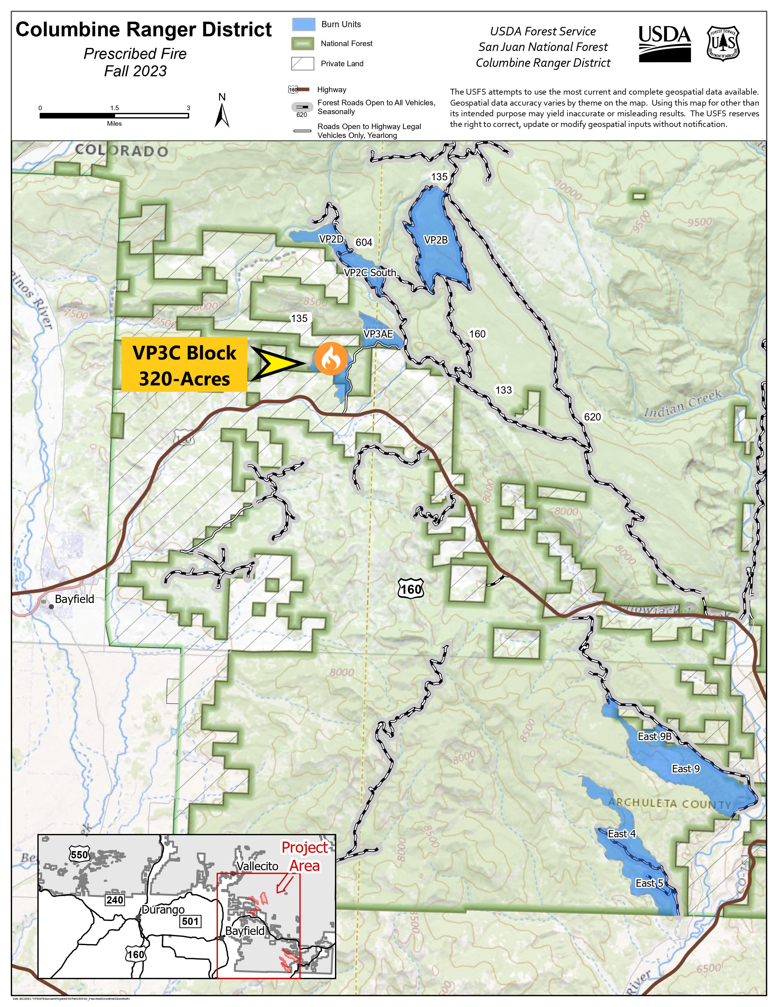
Columbine District VallecitoPiedra Unit Prescribed Fire VP3C Block 09262023
Related Incident: 2025 San Juan National Forest Prescribed Fire Program
Publication Type: News
Prescribed burning operations on the USDA Forest Service - San Juan National Forest, Columbine Ranger District, Vallecito/Piedra Unit, have concluded ignitions for today, September 26th, at 6:00pm. Crews completed 100% of the prescribed 320-acre goal.
Tomorrow, September 27th, crews will start Mop-Up procedures on the Vallecito/Piedra Block. Some smoke may be visible through the next few days.
Pagosa Ranger DistrictEcho Canyon UnitPrescribed Fire 9262023
Related Incident: 2025 San Juan National Forest Prescribed Fire Program
Publication Type: News
Prescribed burning operations on the USDA Forest Service - San Juan National Forest, Pagosa Ranger District, Echo Canyon Unit-Block 4, have concluded ignitions for today, September 26th, at 4:58pm. Crews completed 95% of the prescribed 450-acre goal.
Weather and fuel conditions permitting, the San Juan National Forest Prescribed Fire Project will continue tomorrow on the Echo Canyon Unit. If weather conditions are not deemed favorable for ignition, the prescribed burn will be re-scheduled for a later date. Some smoke may be visible through the next few days.
To learn more on prescribed fire please visit: https://tinyurl.com/mtrt45tv
To learn more about air quality in your area, please visit: https://www.airnow.gov/?city=Arboles&state=CO&country=USA
FOREST SERVICE BAER TEAM BEGINS POSTFIRE ASSESSMENT OF SMITH RIVER COMPLEX 2023 SRF LIGHTNING COMPLEX FIRES
Related Incident: 2023 SRF Lightning Complex Post-Fire BAER
Publication Type: Announcement
FOREST SERVICE BAER TEAM BEGINS
POST-FIRE ASSESSMENT OF SMITH RIVER COMPLEX & 2023 SRF LIGHTNING COMPLEX FIRES
A Forest Service Burned Area Emergency Response (BAER) team has been established by the Six Rivers National Forest (NF) to begin a post-fire burned area emergency assessment of the wildfires within the Smith River Complex and 2023 SRF Lightning Complex. The BAER assessment team is coordinating with local tribes, and other federal, state, and county agencies, such as the Natural Resources Conservation Service (NRCS), National Weather Service (NWS), US Geological Survey (USGS), and National Marine Fisheries Service (NOAA Fisheries) to assess potential post-fire impacts to the burned watersheds. In addition, the Six Rivers BAER team is assisting the Rogue River-Siskiyou National Forest BAER team where the Smith River Complex burned onto their forest lands in California and Oregon. Forest Service BAER team assessments typically take approximately two weeks to complete.
These rapid assessments evaluate the burned area to identify watersheds having increased potential for post-fire flooding, sediment flows and rockslides, and assist land managers to prepare the burned area for seasonal thunder cell storms. The team focus is on potential emergency impacts to life, safety, and property on federal land.
BAER teams generally consist of scientists and specialists including hydrologists, geologists, soil scientists, road engineers, botanists, biologists, archeologists, and geographic information specialists, and the BAER team assessing these two complexes burned areas has a full complement of resource specialists. BAER teams conduct surveys to collect field data within burned areas to analyze through mapping (GIS) and computer models. Findings are presented along with recommended emergency stabilization treatments in a BAER assessment report.
The team utilizes satellite imagery and specialist data to analyze and produce a runoff map that shows the levels of hydrological potential flows during rain events. This is the first step in assessing potential watershed impacts from wildfires to any federal values that may be at-risk from potential increased flooding, sedimentation, debris flows, and rockslides. The BAER team will produce a report that describes potential threats associated with the burned area’s post-fire conditions and often include recommended emergency stabilization measures and actions. BAER emergency response efforts are focused on the protection of human life, safety, and property, as well as critical cultural and natural resource values such as the water quality of streams and wetlands on federal lands.
BAER reports are shared with interagency cooperators such as California Office of Emergency Services (CalOES), NRCS, and counties who work with downstream private home and landowners to prepare for potential post-fire flooding and debris flow impacts. Homes or businesses that could be impacted by flooding from federal land that resulted from wildfires may be eligible for flood insurance coverage from the National Flood Insurance Program (NFIP). Information about NFIP is available through FEMA at www.fema.gov/national-flood-insurance-program, or www.floodsmart.gov/wildfires. Other flood preparedness information is available at www.ready.gov/floods at www.floodsmart.gov/.
BAER SAFETY MESSAGE: Everyone near and downstream from the burned areas should remain alert and stay updated on weather conditions that may result in heavy rains and increased water runoff. Flash flooding may occur quickly during heavy rain events – be prepared to act. Current weather and emergency notifications can be found at the National Weather Service websites: https://www.weather.gov/eka/ and www.weather.gov/sto/.
Smith River Complex Post-Fire BAER Assessment information is available at:
Casrf Smith River Complex Postfire Baer Information | InciWeb (nwcg.gov)
2023 SRF Lightning Complex Post-Fire BAER Assessment information is available at:
Casrf 2023 Lightning Complex Postfire Baer Information | InciWeb (nwcg.gov)
FOREST SERVICE BAER TEAM BEGINS POSTFIRE ASSESSMENT OF SMITH RIVER COMPLEX 2023 SRF LIGHTNING COMPLEX FIRES
Related Incident: Smith River Complex Post-Fire BAER
Publication Type: Announcement
FOREST SERVICE BAER TEAM BEGINS
POST-FIRE ASSESSMENT OF SMITH RIVER COMPLEX & 2023 SRF LIGHTNING COMPLEX FIRES
A Forest Service Burned Area Emergency Response (BAER) team has been established by the Six Rivers National Forest (NF) to begin a post-fire burned area emergency assessment of the wildfires within the Smith River Complex and 2023 SRF Lightning Complex. The BAER assessment team is coordinating with local tribes, and other federal, state, and county agencies, such as the Natural Resources Conservation Service (NRCS), National Weather Service (NWS), US Geological Survey (USGS), and National Marine Fisheries Service (NOAA Fisheries) to assess potential post-fire impacts to the burned watersheds. In addition, the Six Rivers BAER team is assisting the Rogue River-Siskiyou National Forest BAER team where the Smith River Complex burned onto their forest lands in California and Oregon. Forest Service BAER team assessments typically take approximately two weeks to complete.
These rapid assessments evaluate the burned area to identify watersheds having increased potential for post-fire flooding, sediment flows and rockslides, and assist land managers to prepare the burned area for seasonal thunder cell storms. The team focus is on potential emergency impacts to life, safety, and property on federal land.
BAER teams generally consist of scientists and specialists including hydrologists, geologists, soil scientists, road engineers, botanists, biologists, archeologists, and geographic information specialists, and the BAER team assessing these two complexes burned areas has a full complement of resource specialists. BAER teams conduct surveys to collect field data within burned areas to analyze through mapping (GIS) and computer models. Findings are presented along with recommended emergency stabilization treatments in a BAER assessment report.
The team utilizes satellite imagery and specialist data to analyze and produce a runoff map that shows the levels of hydrological potential flows during rain events. This is the first step in assessing potential watershed impacts from wildfires to any federal values that may be at-risk from potential increased flooding, sedimentation, debris flows, and rockslides. The BAER team will produce a report that describes potential threats associated with the burned area’s post-fire conditions and often include recommended emergency stabilization measures and actions. BAER emergency response efforts are focused on the protection of human life, safety, and property, as well as critical cultural and natural resource values such as the water quality of streams and wetlands on federal lands.
BAER reports are shared with interagency cooperators such as California Office of Emergency Services (CalOES), NRCS, and counties who work with downstream private home and landowners to prepare for potential post-fire flooding and debris flow impacts. Homes or businesses that could be impacted by flooding from federal land that resulted from wildfires may be eligible for flood insurance coverage from the National Flood Insurance Program (NFIP). Information about NFIP is available through FEMA at www.fema.gov/national-flood-insurance-program, or www.floodsmart.gov/wildfires. Other flood preparedness information is available at www.ready.gov/floods at www.floodsmart.gov/.
BAER SAFETY MESSAGE: Everyone near and downstream from the burned areas should remain alert and stay updated on weather conditions that may result in heavy rains and increased water runoff. Flash flooding may occur quickly during heavy rain events – be prepared to act. Current weather and emergency notifications can be found at the National Weather Service websites: https://www.weather.gov/eka/ and www.weather.gov/sto/.
Smith River Complex Post-Fire BAER Assessment information is available at:
Casrf Smith River Complex Postfire Baer Information | InciWeb (nwcg.gov)
2023 SRF Lightning Complex Post-Fire BAER Assessment information is available at:
Casrf 2023 Lightning Complex Postfire Baer Information | InciWeb (nwcg.gov)
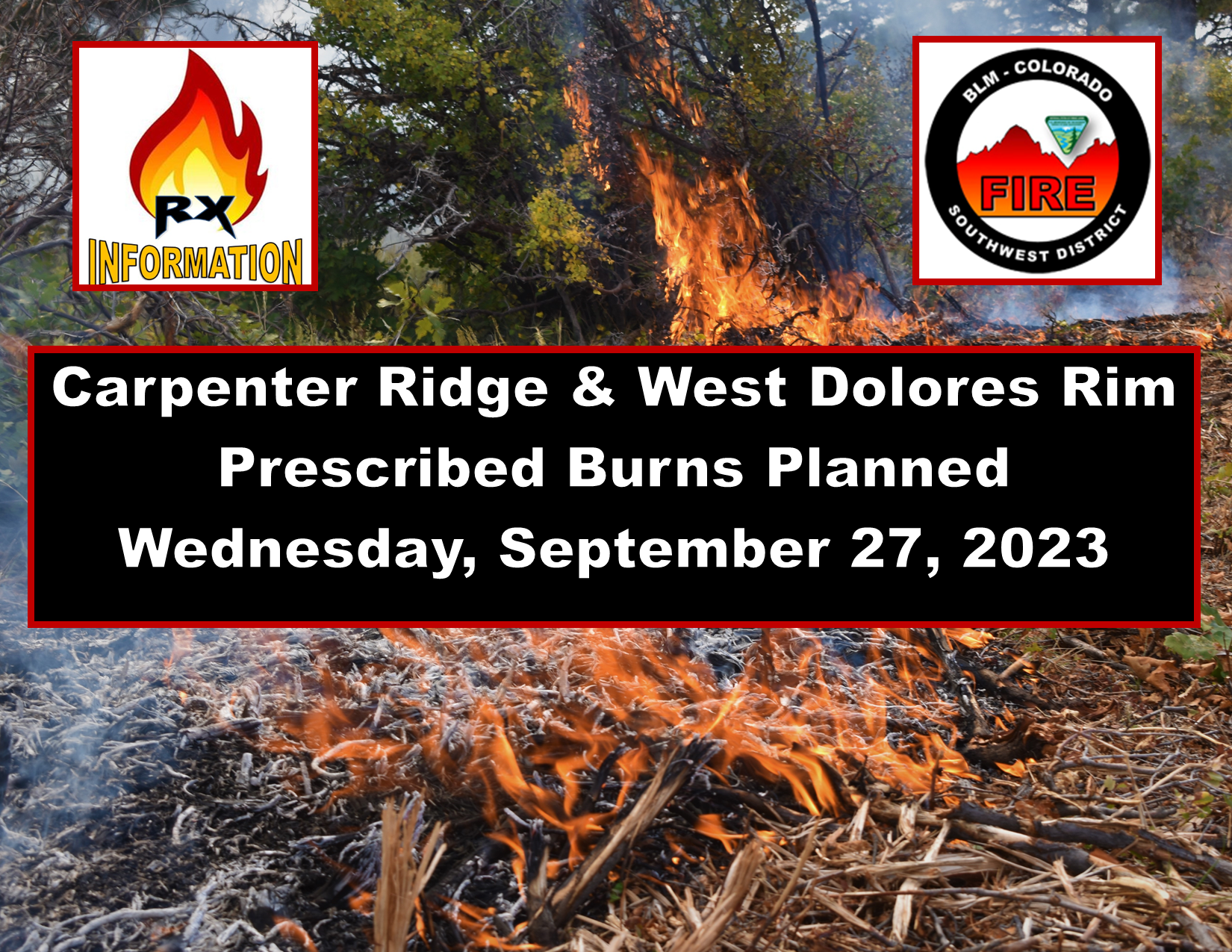
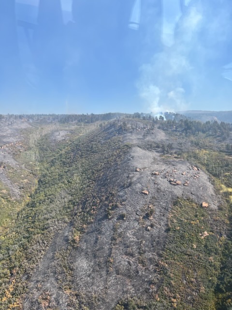
Carpenter Ridge and West Dolores Rim Prescribed Burns planned for Sept 27 2023
Related Incident:
Publication Type: Announcement
Bureau of Land Management (BLM) Southwest District plans to conduct two prescribed fire treatments Wednesday, September 27, 2023, if conditions allow.
Carpenter Ridge project area is located two miles outside of Paradox Valley, CO, between Q13 and R3 roads (Rimrocker Trail route). Firefighters plan to burn 200 acres of oak brush and pine tree litter. The Rimrocker trail, Q13 and R5 roads will remain open but may experience some smoke impacts throughout the burning period.
Firefighters plan to resume ignitions on West Dolores Rim project area located east of Egnar, CO. They successful completed 620 acres in previous days, and plan to burn an additional 400 acres in units 23 and 24.
The projects are part of the BLM’s ongoing commitment to protect human health and safety while maintaining or enhancing forest and woodland health and functionality. The BLM obtained smoke permits from the Colorado State Air Pollution Control Division, which identify atmospheric conditions under which the burns can be implemented. Prescribed fire smoke may affect your health. For more information, visit CO Dept of Public Health & Environment - Wood smoke and health.
More information on Southwest District prescribed fuel treatments at InciWeb_Southwest District BLM Prescribed Fire and follow our Facebook-BLM Southwest District or Twitter-@SWD_Fire pages.
Settings - change map background and toggle additional layers
Filter - control incident types displayed on map.
Zoom to your location
Reset map zoom and position
Could not determine your location.
Show Legend
 Wildfire
 Prescribed Fire
 Burned Area
Response
Burned Area
Response Other
Other
2023 SRF Lightning Complex Post-Fire BAER
Unit Information
Incident Contacts
Settings - change map background and toggle additional layers
Filter - control incident types displayed on map.
Zoom to your location
Reset map zoom and position
Could not determine your location.
Show Legend
- Wildfire
- Prescribed Fire
- Burned Area
Response
- Other
Smith River Complex Post-Fire BAER
Unit Information
Incident Contacts
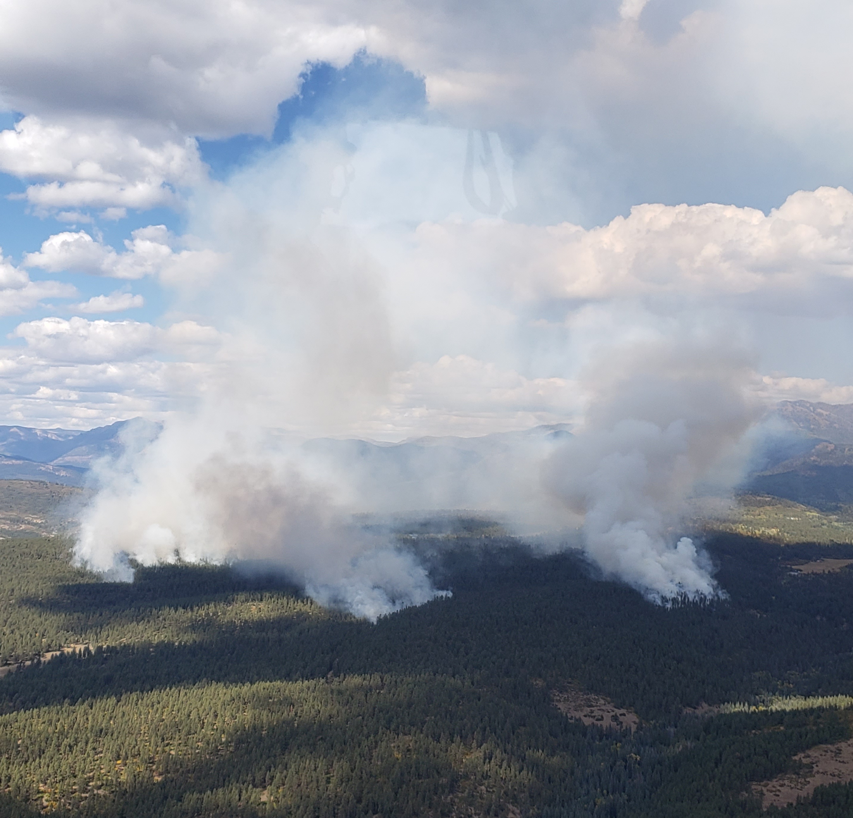
PM Update 9262023
Related Incident: Cow Creek Prescribed Burn
Publication Type: Announcement
Ignitions have ceased for the day on the #CowCreekRx burn east of Gateway, Colorado. Firefighters were able to successfully complete an additional 1000 acres today, Tuesday, Sept. 26.
If conditions allow, firefighters plan to ignite tomorrow, Wednesday, Sept. 27, in order to complete burning operations for the Unit 1/North Unit area of the map below.
A prescribed fire is a planned fire used to accomplish management objectives. For example, one of the objectives for this burn is to reduce the overgrown and crowded fuels in the area, therefore creating a mosaic landscape that is more resistant to catastrophic wildfire. This prescribed fire is also aiming to enhance productive vegetation in the oak brush and mountain shrub parts of the burn area, in order to increase habitat for wildlife and livestock.
Prescription burning is important to maintain a fire-adapted ecosystem and is essential for wildfire prevention. For more information on prescription burning and its use, please visit: https://www.fs.usda.gov/managing-land/prescribed-fire
For information on the Cow Creek RX burn, visit: https://inciweb.nwcg.gov/incident-information/cogmf-cow-creek-prescribed-burn