
Happy Camp Complex Daily Update September 27 2023
Related Incident: 2023 Happy Camp Complex Klamath NF
Publication Type: News
Wednesday, September 27, 2023
Weather: Light showers are expected this morning in the fire area with clear skies this afternoon. The fire area received just under 2 inches of rain in the past 24 hours. Today winds are expected to come out of the west-southwest at 6-9 mph with gusts up to 20 mph on ridgetops.
FIRE BEHAVIOR: Little active fire behavior is expected. There are 5 small spots of isolated heat sources left across both fires. These heat sources are ground fuels such as smoldering stumps and continue to show up in the IR monitoring. Interior fuels continue to burn but are producing little smoke.
UFISH FIRE: 7,603 acres at 78% containment.
ELLIOT FIRE: 13,649 acres at 70% containment.
In general, both fire areas are looking good; neither fire has moved beyond it’s perimeter in over a week. The main work now is hazard tree mitigation and suppression repair. After the roads dry sufficiently so that firefighters and equipment can travel on them without doing more damage, hazard tree mitigation will continue. The target areas are: Ufish Fire - the 17N10 Rd to the north and the Titus Creek Rd area that was used as a primary control line. Elliot Fire the 17N19 Rd system north to the Bear Creek Rd system. For suppression repair, work is ongoing on Independence Creek Rd, and Hot Potato Ridge and other areas just north of the Ufish fire perimeter. The 17N20 Rd in the interior of the Elliot Fire is also being repaired.
SMOKE EFFECTS: Smoke is not anticipated to be an issue in Happy Camp or along the Hwy 96 corridor. The rain has cleaned the air and tamped down the fires and thus smoke production. Smoke may be an issue next week if the surrounding fires (Six Rivers Complex and the Smith River Complex Fires) continue to burn.
EVACUATIONS: All warning zones around the Ufish and Elliot Fires have been dropped. View current Siskiyou County evacuation area status by visiting https://community.zonehaven.com.
CLOSURES: A closure order has been implemented in the Klamath National Forest. Find more information at https://bit.ly/KlamathNFAlertsNotices.
As hunting season continues, please be aware of area closures within our national forests. Contact local Forest Service offices for specific information.
DELAYS: One-way traffic control is on Highway 96 at various locations, from 5 miles east of Seiad to the Klamath River. https://roads.dot.ca.gov/
Wednesday September 27th Payette NF Update Southwest Idaho Wildfire Crisis Strategy Prescribed Burn
Related Incident: Southwest Idaho Wildfire Crisis Strategy Prescribed Fire
Publication Type: News
Tuesday was a successful day on both the Brush and Weasel prescribed burns. Hand ignitions and Helicopter ignitions took place. The Brush Crews treated over 900 acres using hand ignitions along forest service roads and helicopter ignitions inside those treated lines. Using hand ignitions, the Weasel Crews spent the day focusing on outlining the area targeted for burning on Wednesday.
Today's Plan for the Brush will be to target an additional 930 acres, again implementing both hand ignitions and helicopter ignitions. The Weasel Prescribed burn is planning on helicopter ignitions inside the burn perimeter that was created on Tuesday, expecting to treat 200 acres.
The Robinson Prescribed Burn Crews are planning on hand ignitions today and expect to treat 150 to 175 acres.
With the forecast calling for some light precipitation and cooler temperatures over all three burn units, fuels may not be as receptive.
Willamette National Forest rescinds restrictions reduces fire danger level
Related Incident: Bedrock FirePetes Lake FireLookout Fire2023 Horse Creek Fire
Publication Type: Announcement
Springfield, Ore. – Sept. 26, 2023 — Due to recent rainfall and cooler temperatures, the Willamette National Forest will rescind public use restrictions, lower the fire danger level to “low”, and reduce the Industrial Fire Precaution Level to IFPL I on Sept. 27, 2023.
Campfires will once again be allowed outside of campgrounds, and restrictions on chainsaws, off-highway vehicles, and smoking will be lifted. However, even with the reduced fire risk, it is still important to never leave a campfire unattended and completely extinguish it so it’s cold to the touch.
The cancellation of public use restrictions, also known as fire restrictions, applies to all lands within the Willamette National Forest, including the Three Sisters, Mount Jefferson, Mount Washington, Waldo Lake, and Diamond Peak Wilderness areas.
Despite the change in conditions, the Forest still has closures in place for some areas due to active wildfires and ongoing emergency response work. To check the status of a location before entering the Forest, visit Willamette National Forest - Alerts & Notices (usda.gov)
Firefighters and heavy equipment crews continue to do fire work and suppression repair in the Forest and along forest roads. This includes road work and danger tree removal, as well the movement of firefighting vehicles and equipment.
Visitors are encouraged to exercise caution and check road reports before entering or driving in those areas. For the latest information on road conditions, please monitor TripCheck for updates: https://tripcheck.com/
Visit our website at www.fs.usda.gov/willamette and follow us on Facebook and Twitter @WillametteNF for current fire information. To report a wildfire, please call 9-1-1.
Umpqua Fires 92723
Related Incident: 2023 Chilcoot Fire UNFBrice Creek FireGrizzly FireDinner FireRidge Fire
Publication Type: News
September 27, 2023
Daily Update
Dinner, Grizzly, Brice, Chilcoot and Ridge Fires
Total personnel: 240 | Resources: 7 engines and 3 crews
Northwest Team 13 assumed command of the Dinner, Grizzly, Brice, Chilcoot and Ridge fires at 6pm on 9/25/23. In order to expedite suppression repair and backhaul operations, 4 crews will be added to incident resources in the next 72 hours.
Dinner: Resources were able to return to the field today after the rain event utilizing a pause in the weather to complete suppression repair. Containment – 95%
Grizzly: Firefighters are patrolling the fire perimeter in the wilderness after a measurable amount of precipitation fell throughout the fire area. Fire managers are assessing repair work as needed. Containment – 0%
Brice: Roads are drying out which allows firefighters to re-engage fire suppression and repair activities. Containment – 95%
Chilcoot: Engines and crews continue suppression action on the southern part of fire. There is still heat on the perimeter from tactical firing operations on Thursday. Firefighters are focusing efforts by reducing heat on the line and working into the fire interior. Containment – 67%
Ridge: Suppression and repair are almost complete. Fire managers are mobilizing a Roads Group to grade and stabilize roads to return them to Forest standards. Work will commence on Forest Road 3850 today. Containment – 95%
Safety and Closures: There is a forest closure for portions of the Umpqua National Forest in response to fire activity in the area to protect public and wildland firefighter safety. A Closure Order for the Canton Creek area has been issued by Bureau of Land Management (BLM): Chilcoot Ridge Fire Emergency Closure Order BLM Roseburg District.
Fire Information: (541) 900-5862, 8:00 AM – 5:00 PM Email: 2023.chilcoot@firenet.gov
Facebook:
https://www.facebook.com/chilcootridgefires2023
https://www.facebook.com/bricecreekdinnergrizzlyfires2023/
Inciweb:
Grizzly Fire Inciweb: https://inciweb.wildfire.gov/incident-information/orupf-grizzly-fire
Chilcoot Fire Inciweb: https://inciweb.wildfire.gov/incident-information/orupf-2023-chilcoot-fire-unf
Morning UpdateWednesday September 27 2023
Related Incident: Lookout FireBedrock FirePetes Lake Fire2023 Horse Creek Fire
Publication Type: News
Wednesday, September 27, 2023 - Morning Update
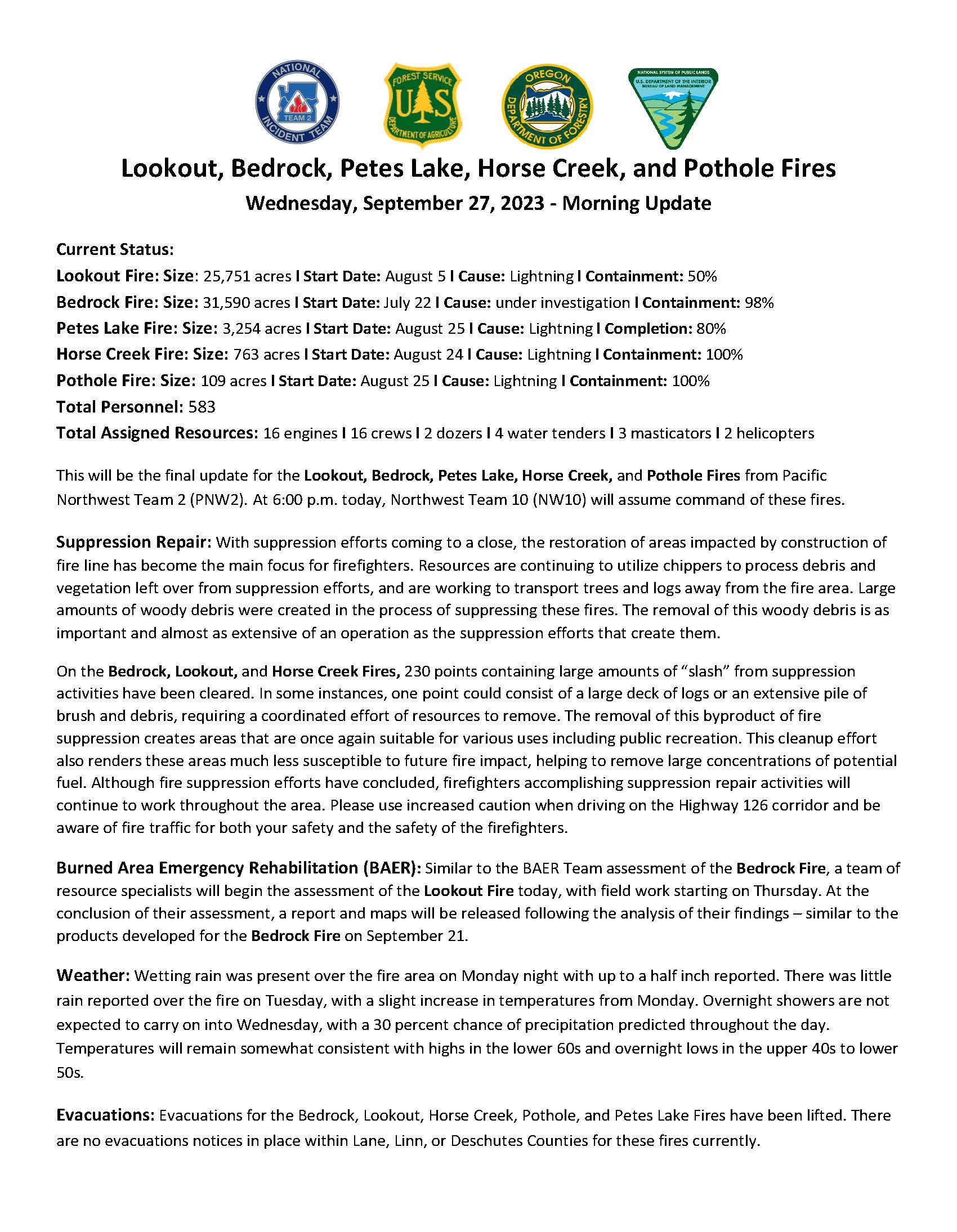
Current Status:
Lookout Fire: Size: 25,751 acres l Start Date: August 5 l Cause: Lightning l Containment: 50% Bedrock Fire: Size: 31,590 acres l Start Date: July 22 l Cause: under investigation l Containment: 98%
Petes Lake Fire: Size: 3,254 acres l Start Date: August 25 l Cause: Lightning l Completion: 80%
Horse Creek Fire: Size: 763 acres l Start Date: August 24 l Cause: Lightning l Containment: 100%
Pothole Fire: Size: 109 acres l Start Date: August 25 l Cause: Lightning l Containment: 100%
Total Personnel: 583
Total Assigned Resources: 16 engines l 16 crews l 2 dozers l 4 water tenders l 3 masticators l 2 helicopters
This will be the final update for the Lookout, Bedrock, Petes Lake, Horse Creek, and Pothole Fires from Pacific Northwest Team 2 (PNW2). At 6:00 p.m. today, Northwest Team 10 (NW10) will assume command of these fires.
Suppression Repair: With suppression efforts coming to a close, the restoration of areas impacted by construction of fire line has become the main focus for firefighters. Resources are continuing to utilize chippers to process debris and vegetation left over from suppression efforts, and are working to transport trees and logs away from the fire area. Large amounts of woody debris were created in the process of suppressing these fires. The removal of this woody debris is as important and almost as extensive of an operation as the suppression efforts that create them.
On the Bedrock, Lookout, and Horse Creek Fires, 230 points containing large amounts of “slash” from suppression activities have been cleared. In some instances, one point could consist of a large deck of logs or an extensive pile of brush and debris, requiring a coordinated effort of resources to remove. The removal of this byproduct of fire suppression creates areas that are once again suitable for various uses including public recreation. This cleanup effort also renders these areas much less susceptible to future fire impact, helping to remove large concentrations of potential fuel. Although fire suppression efforts have concluded, firefighters accomplishing suppression repair activities will continue to work throughout the area. Please use increased caution when driving on the Highway 126 corridor and be aware of fire traffic for both your safety and the safety of the firefighters.
Burned Area Emergency Rehabilitation (BAER): Similar to the BAER Team assessment of the Bedrock Fire, a team of resource specialists will begin the assessment of the Lookout Fire today, with field work starting on Thursday. At the conclusion of their assessment, a report and maps will be released following the analysis of their findings – similar to the products developed for the Bedrock Fire on September 21.
Weather: Wetting rain was present over the fire area on Monday night with up to a half inch reported. There was little rain reported over the fire on Tuesday, with a slight increase in temperatures from Monday. Overnight showers are not expected to carry on into Wednesday, with a 30 percent chance of precipitation predicted throughout the day. Temperatures will remain somewhat consistent with highs in the lower 60s and overnight lows in the upper 40s to lower 50s.
Evacuations: Evacuations for the Bedrock, Lookout, Horse Creek, Pothole, and Petes Lake Fires have been lifted. There are no evacuations notices in place within Lane, Linn, or Deschutes Counties for these fires currently.
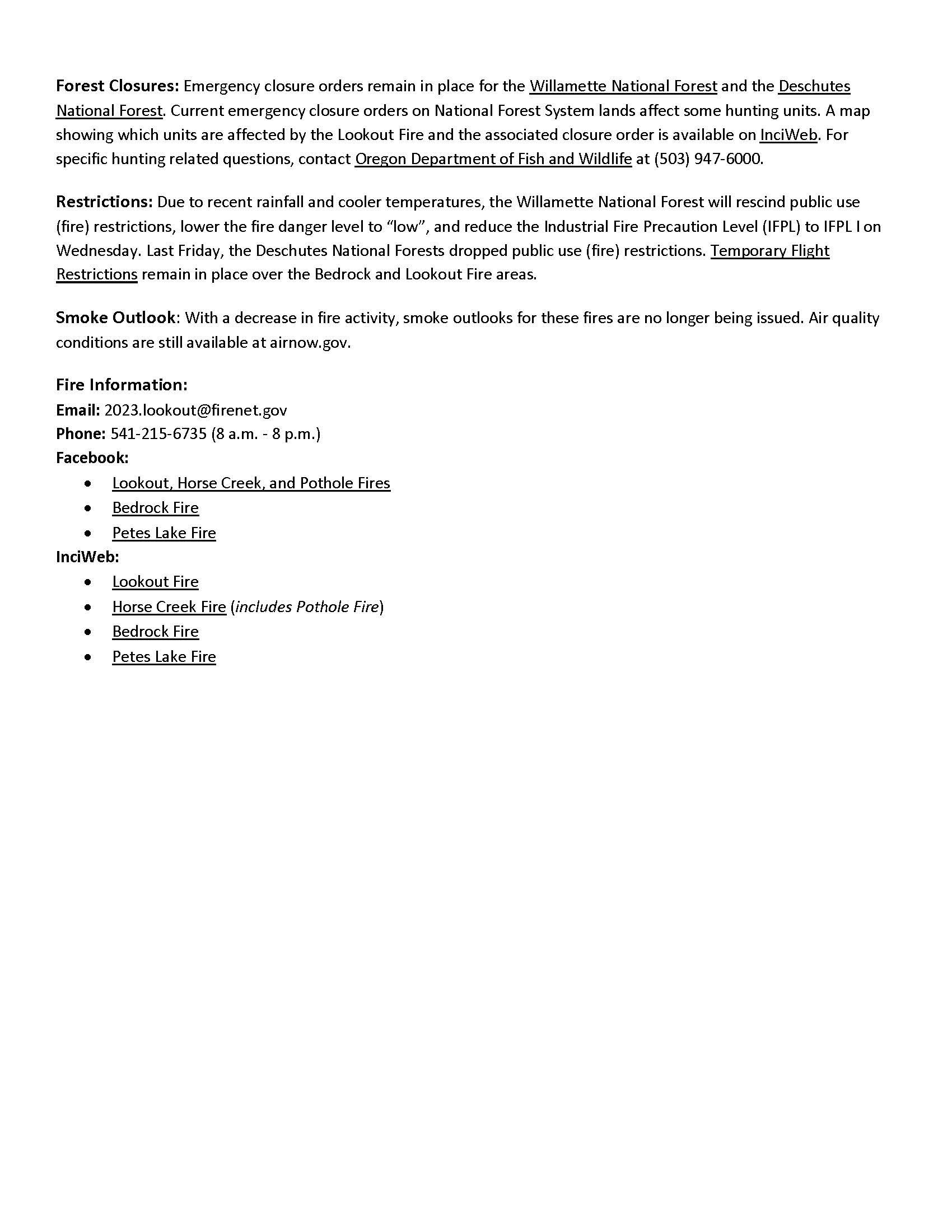
Forest Closures: Emergency closure orders remain in place for the Willamette National Forest and the Deschutes National Forest. Current emergency closure orders on National Forest System lands affect some hunting units. A map showing which units are affected by the Lookout Fire and the associated closure order is available on InciWeb. For specific hunting related questions, contact Oregon Department of Fish and Wildlife at (503) 947-6000.
Restrictions: Due to recent rainfall and cooler temperatures, the Willamette National Forest will rescind public use (fire) restrictions, lower the fire danger level to “low”, and reduce the Industrial Fire Precaution Level (IFPL) to IFPL I on Wednesday. Last Friday, the Deschutes National Forests dropped public use (fire) restrictions. Temporary Flight Restrictions remain in place over the Bedrock and Lookout Fire areas.
Smoke Outlook: With a decrease in fire activity, smoke outlooks for these fires are no longer being issued. Air quality conditions are still available at airnow.gov.
Fire Information:
Email: 2023.lookout@firenet.gov
Phone: 541-215-6735 (8 a.m. - 8 p.m.)
Facebook:
InciWeb:
- Lookout Fire
- Horse Creek Fire (includes Pothole Fire)
- Bedrock Fire
- Petes Lake Fire
Carpenter Ridge Prescribed Burn Cancelled Sept 27 2023
Related Incident:
Publication Type: Announcement
The Bureau of Land Management (BLM) Southwest District has cancelled Carpenter Ridge prescribed burn for Wednesday, September 27, 2023, due to unfavorable weather forecast. A strong system is moving into the prescribed burn weather forecast area on Thursday afternoon/evening for gusty winds, and low humidity. Firefighters will remain in the area to continue preparing area for a future prescribed fire project.
More information on Southwest District prescribed fuel treatments at InciWeb_Southwest District BLM Prescribed Fire and follow our Facebook-BLM Southwest District or Twitter-@SWD_Fire pages.
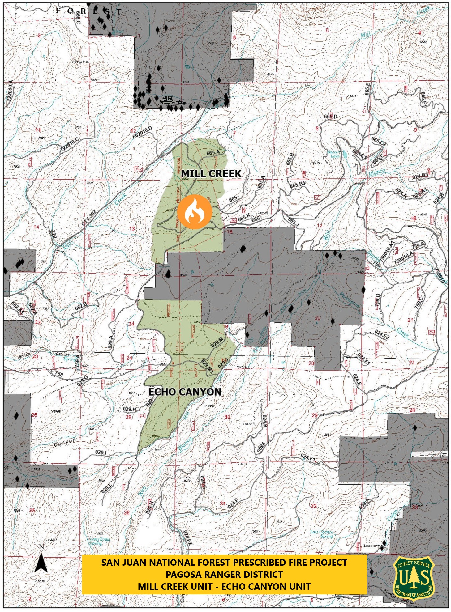
Pagosa Ranger DistrictMill Creek UnitPrescribed Fire 9272023
Related Incident: 2025 San Juan National Forest Prescribed Fire Program
Publication Type: News
Ignitions for todays, September 27, 2023, prescribed burning operation began on the Mill Creek Unit in the Pagosa Ranger District, #SanJuanNF. Today's operation is located off Mill Creek Road and FS-665 Road. Resources will look to complete a goal of 140-acres of prescribed fire. If you are in the area, please exercise caution when around firefighters and fire apparatuses as they will be actively patrolling and working throughout the day. Some smoke may be visible in the area.
Firefighters will work to execute this prescribed fire, aimed at reducing hazardous ground fuels, reducing the risk of unplanned catastrophic wildfire, restoring ponderosa pine ecosystems, and improving wildlife habitat.
Wednesday September 27 2023 Valentine Fire Update and Maps
Related Incident:
Publication Type: News
Size: 8,492 acres
Start Date: August 16, 2023
Cause: Lightning
Completion: 92%
Total personnel: 195
Location: 11 miles northeast of Young, Arizona and 27 miles
east of Payson, Arizona
Fuels: Ponderosa Pine, Hardwood litter and timber
Highlights: Yesterday, crews continued working along the FSRD 411 westward to Lost Salt Canyon. Today, crews will continue with hand and aerial ignitions keeping the line even and working east from FSRD 200 along FSRD 848 and Haigler Creek.
Operations: Yesterday, Crews continued work along FSRD 411 bringing fire along the containment line to Lost Salt Canyon. Hand and aerial ignitions took place on the western portion of the fire along FSRD 200 progressing toward the southwest corner. Today, hand and aerial ignitions will continue as crews bring the fire around the southwest corner along FSRD 200 to FSRD 920.
Fire Ecology: When trees are killed in a fire it’s not always the end of their story; many species depend on ‘snag habitat’. When a tree dies some of the first creatures that show up are wood-boring insects. They tunnel into the tree, providing access for fungi and other insects. This then attracts woodpeckers and other insect eaters, who will further expand these holes while trying to extract insects. Over time these holes grow within the tree, creating homes for other birds and some mammals. Bats roost behind loose bark and raptors often nest in snags or perch in them to look for prey. Eventually the tree will rot and fall, but until then it provides important services to many things.
Weather: Yesterday, temperatures were in the low 80’s with light wind out of the southwest. Today, temperature will be in the high 70’s to low 80’s with light winds expected.
Closures: An emergency closure order for the Valentine Fire has gone into effect as of 6 a.m. Sept. 5, 2023. The public is asked to avoid the fire area. The purpose of the closure order is to protect public health and safety during the Valentine Fire, and to protect assigned firefighting personnel engaging in wildland firefighting operations. Signs and gates will be in place to remind the public not to enter the fire area. Please visit the Alerts and Notices page for more information. https://www.fs.usda.gov/alerts/tonto/alerts-notices.
Safety: The health and safety of firefighters, and the public are always the highest priority. Members of the public are asked to avoid the fire area.
Smoke: The fire will produce considerable amounts of smoke due to excessive fuel accumulation. Smoke from the Valentine Fire may be visible in the surrounding areas for many days. Smoke-sensitive individuals and people with respiratory problems or heart disease are encouraged to take precautionary measures. An interactive smoke map available at, https://www.airnow.gov/wildfires/ allows you to zoom into your area to see the latest smoke conditions.
Information Links and Contacts:
Tonto National Forest https://www.fs.usda.gov/main/tonto/fire
InciWeb https://inciweb.nwcg.gov/incident-information/aztnf-valentine-fire Fire Email 2023.valentine@firenet.gov
Fire Information Line (928)-421-4579 • Office Hours: 8:00 AM – 8:00 PM
South Fork Complex Update September 27 2023
Related Incident: South Fork Complex
Publication Type: News
South Fork Complex Update
Wednesday, September 27, 2023
Fire Information: 916-261-6756, 8 a.m. to 8 p.m.
Email: 2023.southforkcomplex@firenet.gov
Linktree: https://linktr.ee/2023southforkcomplex
3-9 Fire: 2,840 acres with 85% containment
Pellitreau Fire: 3 acres with 100% containment
Pilot Fire: 1,055 acres with 100% containment
Sulphur Fire: 31 acres with 100% containment
3,929 acres and 90% overall containment for the South Fork Complex
A total of 149 personnel, crews, air support, engines, dozers, and water tenders support the incident.
3-9 Fire – Resource Advisors (READs) are working with crews who are continuing repair activities when windows of opportunity occur. Engines are monitoring the interior smoke and heat. Heavy equipment and crews are fully engaged with chipping operations along Route 1. The public can expect to see large dump trucks transporting the chips along Route 1 and Highway 36.
The Pilot Fire is 100% contained. Crews continue to patrol the fire perimeter and engaged in suppression repair when windows of opportunity occur.
The Pellitreau Fire and the Sulfur Fire are 100% contained. Firefighters continue to patrol the fires periodically to ensure fire remains within containment lines.
Weather: Mostly cloudy with a 40% chance of light rain in the morning. Mostly sunny in the afternoon. Winds from the southwest 4 to 8 mph in the morning, shifting to west northwest 5 to 10 mph gusting to 18 mph on ridges in the afternoon. Afternoon highs in the mid-50s to mid-60s, with afternoon humidity dropping to around 50 to 60%.
Forest Closure: Forest Closure Order for the South Fork Complex Fire continues to be in effect and is posted on the Six Rivers National Forest website. Please avoid closed areas.
@U.S. Forest Service - Shasta-Trinity National Forest
@U.S. Forest Service - Six Rivers National Forest
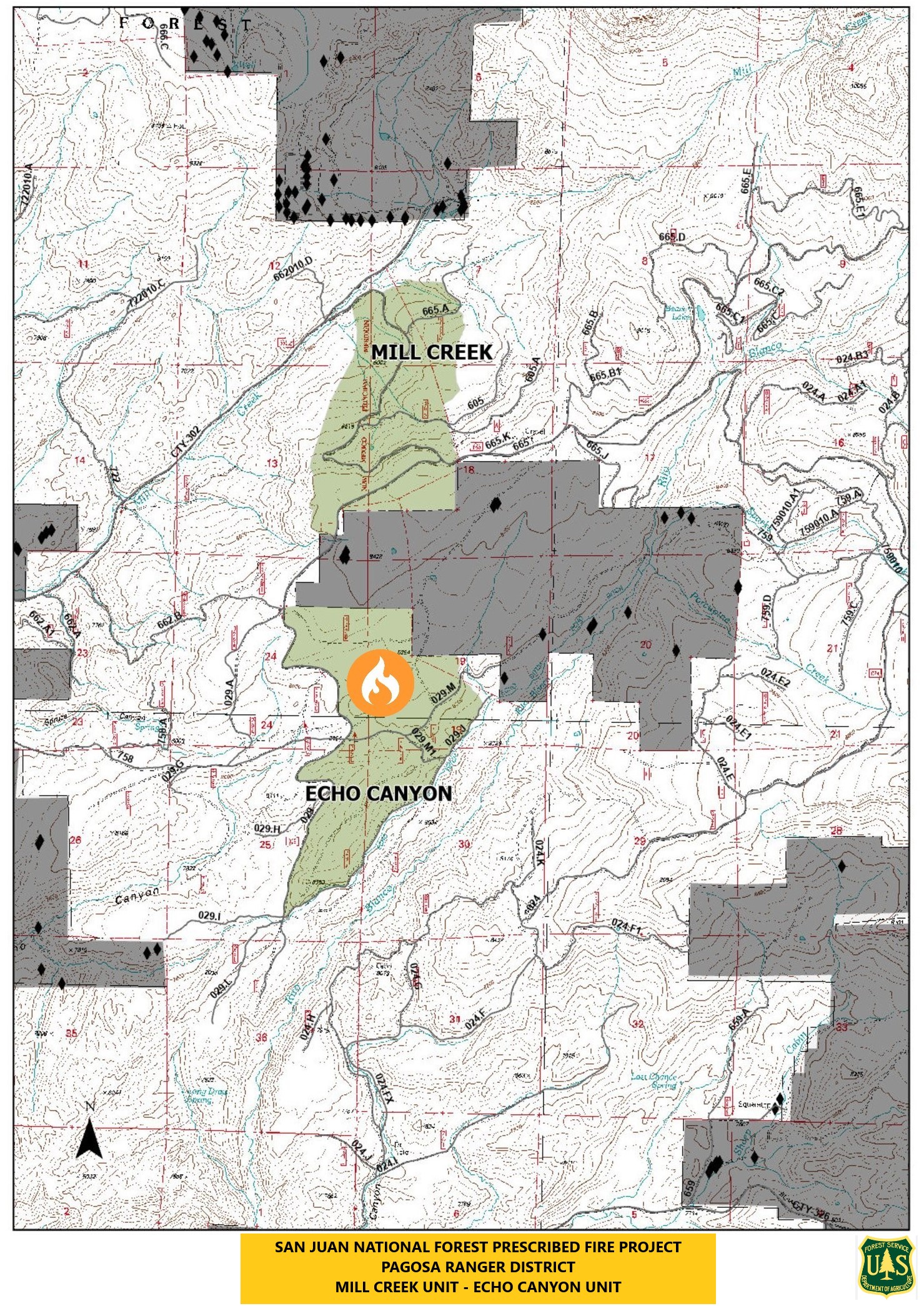
Pagosa Ranger DistrictEcho Canyon UnitPrescribed Fire 9272023
Related Incident: 2025 San Juan National Forest Prescribed Fire Program
Publication Type: News
Ignitions for the USDA Forest Service - San Juan National Forest Prescribed Fire Project continue today, September 27th, 2023, at 11am on the Echo Canyon Unit within the Pagosa Ranger District, USDA Forest Service - San Juan National Forest.
Today's continued operation is located west of Rito Blanco Ranch on the southern end of the #SanJuanNF. Resources have scheduled to finish the Echo Canyon prescribed burn with Block 4. Crews are looking for a completed burn goal of 200-acres.
Sixty-five firefighters will work to execute this prescribed fire, aimed at reducing hazardous ground fuels, reducing the risk of unplanned catastrophic wildfire, restoring ponderosa pine ecosystems, and improving wildlife habitat.
If you are in the area, please exercise extreme caution when around firefighters and fire apparatuses. Smoke may be visible in the area.
For maps and more information, visit InciWeb: https://tinyurl.com/5djdeau4
To learn more about air quality in your area, please visit: https://www.airnow.gov/?city=Arboles&state=CO&country=USA