
Happy Camp Complex Daily Update September 28 2023
Related Incident: 2023 Happy Camp Complex Klamath NF
Publication Type: News
September 28, 2023
Weather: Today will be warmer and drier with mostly clear and sunny skies. Temperature highs will reach up to 70 degrees with wind out of the north-northeast at 5-9mph with gusts up to 12mph.
FIRE BEHAVIOR: Damp fuels will limit the fire’s ability to spread, however, heat remains in heavy ground fuels. No significant spread is expected on either fire within the Happy Camp Complex.
UFISH FIRE: 7,603 acres at 83% containment.
ELLIOT FIRE: 13,649 acres at 80% containment.
The hazard tree group has been able to reengage after waiting for the rain to pass and the muddy roads to dry. Resources on the Elliot and Ufish fires will continue to patrol and monitor from Klamath River to Dillion Creek while seeking opportunities to address heat near the fire perimeter. On the Ufish fire the priority remains the Titus Creek drainage. On the Elliot Fire, the priority is in the Swillup Creek drainage, from Swillup Creek to Pony Peak and into Dillion Creek. Suppression repair resources are in the process of removing equipment from the burn areas where it is safe and secure to make access.
EVACUATIONS: All Evacuation Warnings around the Ufish and Elliot Fires have been dropped. View current Siskiyou County evacuation area status by visiting https://community.zonehaven.com.
CLOSURES: A closure order has been implemented in the Klamath National Forest. Find more information at https://bit.ly/KlamathNFAlertsNotices.
As hunting season continues, please be aware of area closures within our national forests. Contact local Forest Service offices for specific information.
DELAYS: One-way traffic control is on Highway 96 at various locations, from 5 miles east of Seiad to the Klamath River. https://roads.dot.ca.gov/
Morgan Fire Daily Update for September 28 2023
Related Incident: Morgan Fire
Publication Type: News
Morgan Fire Update: Thursday, September 28, 2023
Fire Information line: 541-460-7602 8am-8pm
The Morgan Fire is burning in steep, forested terrain, approximately 21 miles northwest of Lakeview, Oregon and 8 miles north of Quartz Mountain, on both private and National Forest System lands.
Temporary Road Closure: The Fremont-Winema National Forest issued a temporary closure for public safety on a segment of Forest Service Road 2800, between its junction with Forest Road 3428 on the north and Forest Road 2800-016 on the south. A copy of the order and map is on the Forest website: https://www.fs.usda.gov/fremont-winema
There are no longer any evacuation levels associated with the Morgan Fire.
Yesterday: Firefighters worked deeper into the fire, widening the heat-free perimeter around the fire. Crews have begun retrieving pumps and hoses from the fire where they are no longer necessary. As mop-up standards are achieved, fire line repair becomes the priority work. Repair consists of returning the disturbed areas, fire lines, staging areas, helipads etc., to as natural a state as possible. This is to minimize any future damage or impacts to the watersheds due to erosion. Heavy equipment is used to pull back the removed natural vegetation over the dozer lines to protect the soil and make it easier for the ground to recover.
Today’s Activities: Firefighters will search deeper into the perimeter to ensure no potential ignition sources remain near the fire’s edge, and continue fire line repair. As suppression and repair objectives are met, there is a steady demobilization of assigned crews and equipment.
Weather: Lighter, terrain driven winds are expected over the next few days along with dry and mostly sunny conditions. Another system will push into the Pacific Northwest Friday into the weekend, with colder temperatures and additional chances of precipitation through Sunday.
Be safe in the woods! Please avoid travelling in recently burned areas. Fire-weakened trees can fall without warning, and burned ground can be unstable underfoot and contain hidden hot spots.
Fire Information and Links
Inciweb: https://inciweb.nwcg.gov/incident-information/orfwf-morgan-fire
Facebook: https://www.facebook.com/nwteam7
https://www.facebook.com/SCOFMPFIREINFO
https://www.facebook.com/R6FWNF
Morning Update Wednesday September 28 2023
Related Incident: Bedrock FireLookout FirePetes Lake Fire2023 Horse Creek Fire
Publication Type: News
Lookout, Bedrock, Petes Lake, Horse Creek and Pothole Fires
Thursday, September 28, 2023 - Morning Update
Lookout Fire: Size: 25,751 acres l Start Date: August 5 l Cause: Lightning l Containment: 50%
Bedrock Fire: Size: 31,590 acres l Start Date: July 22 l Cause: under investigation l Containment: 98%
Petes Lake Fire: Size: 3,254 acres l Start Date: August 25 l Cause: Lightning l Completion: 80%
Horse Creek Fire: Size: 763 acres l Start Date: August 24 l Cause: Lightning l Containment: 100%
Pothole Fire: Size: 109 acres l Start Date: August 25 l Cause: Lightning l Containment: 100%
Total Assigned Personnel: 467 I 16 engines l 16 crews l 2 dozers l 4 water tenders l 3 masticators l 2 helicopters
Northwest Incident Management Team 10 (NW Team 10), managed by Incident Commander Alan Lawson, took command of the fire at 6 p.m. yesterday. The incoming team members spent the day with their counterparts from the Pacific Northwest Team 2 (PNW2), gathering information to ensure a seamless transition.
Suppression Repair: A half-inch of rain was received over the fire areas the last two days, furthering containment efforts and shifting focus to repair – the process of restoring disturbed areas to their natural state. This is a critical phase, ensuring ecosystem recovery and reducing the risk of future fires. Ongoing suppression repair work across the fire areas includes chipping and removing large amounts of woody debris, drainage work, erosion control, hand and dozer line naturalization and infrastructure repair. Although the fires are largely under control, considerable work remains.
Burned Area Emergency Rehabilitation (BAER): Resource specialists began assessment of the Lookout Fire yesterday. While suppression repair primarily concentrates on damages brought on by firefighting efforts, a BAER team concentrates on impacts caused by the fire itself. Both aim to correct and prevent damage, although from different causes. After a BAER assessment, a report and maps will be released following the analysis of their findings – similar to the products developed for the Bedrock Fire on September 21.
Weather: Light rain will continue over the fire area through Friday, with minimal winds. Temperatures will remain somewhat consistent, with highs in the lower 60s and overnight lows in the 40s.
Evacuations: There are no evacuation notices remaining.
Forest Closures: Emergency closure orders remain in place for the Willamette National Forest. There are no longer emergency closures in place from the Petes Lake Fire. Current emergency closure orders on National Forest System lands may affect some hunting units. For specific hunting related questions, contact Oregon Department of Fish and Wildlife at (503) 947-6000.
Restrictions: Due to recent rainfall and cooler temperatures, the Willamette National Forest rescinded public use (fire) restrictions, lowered the fire danger level to “low” and reduced the Industrial Fire Precaution Level (IFPL) to IFPL I on Wednesday. Last Friday, the Deschutes National Forests dropped public use (fire) restrictions. Temporary Flight Restrictions remain in place.
Smoke Outlook: With decreased fire activity, smoke outlooks for these fires are no longer being issued. Air quality conditions are still available at airnow.gov.
September 28 29 30 update for Southwest Idaho Wildfire Strategy Prescribed Burn
Related Incident: Southwest Idaho Wildfire Crisis Strategy Prescribed Fire
Publication Type: News
Southwest Idaho Wildfire Crisis Strategy Prescribed Burn
Thursday, Friday, Saturday, September 28-30th Active unit/projects
Each prescribed burn project in the Southwest Idaho Wildfire Crisis Strategy Prescribed Burn area is divided into smaller units for fire operations, allowing firefighters to manage and control the burning area.
Council Ranger District:
Weasel (13 miles Northwest of Council) – Wednesday work continued in the Peak Mountain unit with an additional 150 acres treated. For the next three days, the intention is to monitor progress on treated areas, patrol the perimeter, and remove any debris on roadways.
Weiser Ranger District:
Robinson (22 miles Northwest of Weiser) – Wednesday crews were able to burn 85 acres. For the next three days, firefighters will be ensuring lines are holding, monitoring, and patrolling.
New Meadows Ranger District:
Brush (10 miles Northwest of New Meadows) – Wednesday’s weather impacted burning plans across the Brush Burn area. Crews spent the day holding and monitoring areas treated on Tuesday. With better conditions forecasted, firefighters will be hand igniting today and into the weekend. If fuels are receptive, helicopter ignitions will resume. 700 acres are targeted.
Cold (Lost Valley Reservoir area) – Patrol and Monitoring continues. Some of the burn areas are still showing heat so firefighters are checking regularly.
Goose Creek – Spot burning on 60 acres is planned today. Patrolling and monitoring continue on previously burned areas.
An overview of all the planned prescribed burn areas in the Payette National Forests is available here: bit.ly/PNFprescribedburn2023
For the most current information about prescribed burning projects please visit the Payette Facebook page or visit the Payette National Forest planned fuels treatments map at https://tinyurl.com/Payette-Prescribed-Fire-Map
For more information on the Forest Service Wildfire Crisis Strategy and the Southwest Idaho Landscape project, visit this link: Southwest Idaho Landscape Project
Anvil and Flat Fires Update September 28 2023
Related Incident: Anvil FireFlat Fire
Publication Type: News
Anvil Fire
Size: 21,911 acres Start Date: August 25, 2023 Location: 8 miles east of Port Orford, OR
Containment: 27% Total personnel: 1,131 Resources: 32 crews, 10 helicopters, 46 engines
Yesterday, firefighters continued working on and patrolling containment lines. Portions of the fire remain too wet for dozers to construct new line. On the east side of the Anvil Fire, crews continue scouting for opportunities to build containment lines where it is safe and advantageous to work.
Today, hotshot crews are assessing opportunities on the northwest corner of the fire to create containment lines. Minimal fire behavior is anticipated through the weekend, with additional rain expected on Friday. Fire behavior may increase in the coming weeks, until ongoing, consistent rain covers the fire area. The fire will continue to smolder in heavy vegetation and downed timber until humidity drops and temperatures warm enough to allow flames to burn more actively again.
Evacuations: Curry County Sheriff’s Office has identified four evacuation zones around the Anvil Fire. On Monday afternoon, the Sheriff was able to reduce the evacuation levels. Zones 1, 2, and 4 are now in Level 2 “Be Set” status. Residents may return home but should be prepared to evacuate should fire activity increase again. Zone 3 is now in Level 1 “Ready” status. All residents should remain attentive to changing conditions until the fire is more fully contained and the evacuations can be lifted completely. View the interactive evacuation map at https://bit.ly/AnvilEvacs. Sign up for Curry Co. emergency alerts at https://bit.ly/CurryCoEM.
Area and Road Closures: For the safety of firefighters and the public, the Rogue River-Siskiyou National Forest (RRSNF) and Coos Bay District Bureau of Land Management have issued closure orders for the Anvil Fire area. Find maps and closure information at https://inciweb.wildfire.gov/incident-closures/orrsf-anvil-fire.
Fire Restrictions: On Sept. 27 at 12:01 am, the Rogue River Siskiyou National Forest lifted all public Use Restrictions on Forest lands and moved to “moderate” fire danger. The Industrial Fire Precaution Level was reduced to Level 1. Public Use Restrictions on the Wild Section of the Rogue River are at Stage 1- campfires must be in a fire pan below the high-water mark.
Flat Fire
Size: 34,242 acres Start Date: July 15, 2023 Location: 2 miles southeast of Agness, OR Containment: 75% Total personnel: 11 Resources: 3 engines
Crews continue to implement the suppression repair plan on the Flat Fire. Additional crews, including excavators, will work on cleaning up the fire line and returning them to a natural state. The RRSNF closure on the Flat Fire remains in effect. For the latest information, please visit: https://bit.ly/RRSNFAlerts
General Information
Weather: Today will bring light winds moving from the northeast to the northwest in the afternoon. On Friday, there is a 50% chance of wetting rain across the fire. Over the weekend, conditions will dry out and winds are predicted to come from the north.
Smoke: Smoke may begin to increase as fuels dry out and fire activity increases. Visit https://bit.ly/SWORsmoke for current smoke and air quality updates. Please drive slowly and with headlights on through any fire area. Caltrans issued a schedule of road closures and lane restrictions on US-199 northeast from Crescent City. Local law enforcement cautions against any non-essential traffic along this route. For specific information on road access, please see the Caltrans QuickMap site, https://quickmap.dot.ca.gov/ and Oregon Department of Transportation site, https://www.tripcheck.com/. Do not use forest roads for alternate routes.
Contact Fire Information: (541) 216-4579 or (541) 237-6369
Email: 2023.anvil@firenet.gov
Facebook: facebook.com/flatfireoregon2023
X/Twitter: twitter.com/RRSNF
Inciweb Anvil Fire: bit.ly/AnvilFireOR
Inciweb Flat Fire: bit.ly/FlatFireOR
Thursday September 28 2023 Valentine fire update and map
Related Incident:
Publication Type: News
Size: 9,015 acres
Start Date: August 16, 2023
Cause: Lightning
Completion: 95%
Total personnel: 200
Location: 11 miles northeast of Young, Arizona and 27 miles
east of Payson, Arizona
Fuels: Ponderosa Pine, Hardwood litter and timber
Highlights: Crews are working to secure the southwest corner of the fire perimeter and increase interior depth prior to the arrival of strong winds over the weekend.
Operations: Wednesday, crews held the perimeter of the fire along FSRD 411 to Lost Salt Canyon and FSRD 200 while other crews cleared snags along FSRD 778. Pumps and hose lines were set up in Haigler Creek to help secure the south-central containment line where there is no road access. Today, aerial and hand ignitions will continue to bring the fire line downslope towards Haigler Creek and FSRD 848. Crews will be patrolling and holding established containment lines throughout the day.
Fire Ecology: Wildlife is rarely killed directly by fire, though uncharacteristically severe fire may cause significant damage to wildlife habitat. Animals that are most vulnerable to fire are those with limited mobility, live above ground and/or are nesting or young when the fire goes through an area. Slower moving fires, like the Valentine, can allow enough time for wildlife to react to the fire, and they often return to the recently burned areas soon after the fire is done burning to take advantage of the new growth.
Weather: Wednesday, temperatures were cooler with an inversion in the morning and light winds. Today, expect high clouds with a slight cool down and sunny in late afternoon as the clouds disperse. Winds are expected to be the same today as yesterday.
Closures: An emergency closure order for the Valentine Fire has gone into effect as of 6 a.m. Sept. 5, 2023. The public is asked to avoid the fire area. The purpose of the closure order is to protect public health and safety during the Valentine Fire, and to protect assigned firefighting personnel engaging in wildland firefighting operations. Signs and gates will be in place to remind the public not to enter the fire area. Please visit the Alerts and Notices page for more information. https://www.fs.usda.gov/alerts/tonto/alerts-notices.
Safety: The health and safety of firefighters, and the public are always the highest priority. Members of the public are asked to avoid the fire area.
Smoke: The fire will produce considerable amounts of smoke due to excessive fuel accumulation. Smoke from the Valentine Fire may be visible in the surrounding areas for many days. Smoke-sensitive individuals and people with respiratory problems or heart disease are encouraged to take precautionary measures. An interactive smoke map available at, https://www.airnow.gov/wildfires/ allows you to zoom into your area to see the latest smoke conditions.
![]()
Information Links and Contacts:
Tonto National Forest https://www.fs.usda.gov/main/tonto/fire
InciWeb https://inciweb.nwcg.gov/incident-information/aztnf-valentine-fire Fire Email 2023.valentine@firenet.gov
South Fork Complex Update September 28 2023
Related Incident: South Fork Complex
Publication Type: News
South Fork Complex Update
Thursday, September 28, 2023
Fire Information: 707-572-7325, 8 a.m. to 5 p.m.
Email: 2023.southforkcomplex@firenet.gov
Linktree: https://linktr.ee/2023southforkcomplex
This will be the last update unless significant changes occur.
3-9 Fire: 2,840 acres with 85% containment
Pellitreau Fire: 3 acres with 100% containment
Pilot Fire: 1,055 acres with 100% containment
Sulphur Fire: 31 acres with 100% containment
3,929 acres and 90% overall containment for the South Fork Complex
A total of 149 personnel, crews, air support, engines, dozers, and water tenders support the incident.
A new flight over the fire areas using infrared to find heat sources occurred in the evening of 9/26/2023. The storm event was not sufficient to fully suppress interior heat sources such as burning stumps and root systems underground. Crews continue to patrol the fire perimeters and work to complete suppression repair.
3-9 Fire –Heavy equipment and crews are fully engaged with chipping operations along Route 1. The public can expect to see large dump trucks transporting the chips along Route 1 and Highway 36.
Weather: 7 Day Outlook:
Thursday: Sunny. Highs 55-65. Min RH 40-60%. Winds light and variable becoming northwest 5 to 10 mph with gusts around 17 mph in the afternoon.
Friday: Partly Cloudy. A slight (20%) chance of afternoon showers. Highs 53-63. Min RH 50-70%. Winds light and variable becoming north-northwest 8 to 12 mph with gusts around 18 mph in the afternoon.
Saturday: Sunny. Highs 55-65. Min RH 35-55%. Winds northwest 6 to 12 mph with gusts around 18 mph.
Sunday: Sunny. Highs 57-67. Min RH 30-50%. Winds light and variable becoming north-northwest 5 to 10 mph with gusts to 17 mph in the afternoon.
Monday: Partly cloudy. Highs 59-69. Min RH 35-55%. Winds west-northwest 5 to 10 mph with gusts around 17 mph.
Tuesday: Sunny. Highs 62-72. Min RH 40-60%. Winds light and variable becoming west-northwest 5 to 10 mph in the afternoon.
Wednesday: Sunny. Highs 64-74. Min RH 35-55%. Winds light and variable becoming west-northwest 5 to 10 mph in the afternoon.
Forest Closure: Forest Closure Order for the South Fork Complex Fire continues to be in effect and is posted on the Six Rivers National Forest website. Please avoid closed areas.
@U.S. Forest Service - Shasta-Trinity National Forest
@U.S. Forest Service - Six Rivers National Forest
PM Update 9272023
Related Incident: Cow Creek Prescribed Burn
Publication Type: Announcement
Work is completed for today, Wednesday, Sept. 27, on the #CowCreekRx Prescribed Burn area located approximately 9 miles east of Gateway, Colorado, and 25 miles southwest of Grand Junction, Colorado. Firefighters spent the day securing the perimeter and completing work on Unit 1 of this prescribed burn plan.
Smoke may be visible in the Gateway and Grand Junction areas. The public is advised not to call 911 for smoke related to this prescribed burn.
Starting tomorrow, Thursday, Sept. 28, this area of the GMUG may begin to experience higher winds. These winds will likely disperse the smoke resulting from this burn, while also increasing smoke production from residual hot areas within the perimeter of this burn area. Firefighters will continue to monitor the Cow Creek Prescribed Burn area during this period of increasing winds and are not planning on further ignitions during the wind event.
Moving forward, the GMUG will be monitoring for a return of favorable prescribed burning conditions for Unit 2 (see map below) for the #CowCreekRx burn.
For more information on how prescribed fire smoke may affect your health, please visit https://www.colorado.gov/pacific/cdphe/wood-smoke-and-health
Prescription (RX) burning is important to maintain a fire-adapted ecosystem and is essential for wildfire prevention. For more information on prescription burning and its use, please visit: https://www.fs.usda.gov/managing-land/prescribed-fire
Daily Fire Update September 27
Related Incident: Hope Fire
Publication Type: News
Fact Sheet for the Hope Fire - September 27, 2023
The Hope Fire was lightning-caused and detected on September 21st. The fire is being managed under a full suppression strategy by local resources from the Dolores Ranger District of the San Juan National Forest. It is currently burning at Hoppe Point located northwest of the McPhee Dam and Reservoir, east of Bradfield Campground.
The location of the fire is within the boundaries of a prescribed fire burn unit. Fire personnel have been working to prepare lines around the estimated 3,000-acre section. Firefighters are reinforcing and using previously defined and prepared control lines to allow this naturally caused wildfire to reduce forest fuels and improve forest health within those boundaries. This will decrease risk of future catastrophic wildfire, protect infrastructure and private lands, and improve forage for wildlife.
Current
- A Type 3 Incident Management Team will assume command of the Hope Fire today to better manage the complexity of the upcoming operational period.
- A planned firing operation to aid in suppression efforts is planned for today. The public will likely see increased smoke.
- The fire continues to creep and smolder within the burn perimeter.
- Firefighters continue to reinforce containment lines around the planning area to support fire suppression efforts.
Outlook
- The weather will be dry and mild through Thursday.
- Firefighters will look for opportunities to reinforce control lines through Thursday as weather permits.
- Increased winds are forecast for the fire area this weekend.
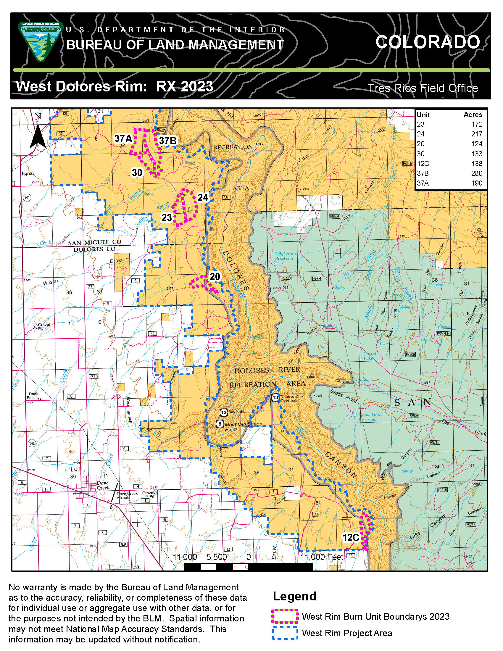
West Dolores Rim prescribed burn completes 400 acres September 27 2023
Related Incident:
Publication Type: Announcement
Today, fire resources on the West Dolores Rim prescribed burn successfully completed units 23 and 24 for a total of 400 acres. This was a second entry burn surrounded by units that have recently been treated. Firefighters will remain in the area through the weekend. Light smoke may be visible east of Egnar, CO.
For more information on BLM Southwest District prescribed burn treatments visit, InciWeb-Southwest District BLM Prescribed Fire https://inciweb.wildfire.gov/ and follow BLM Southwest District Facebook and Twitter @SWD_Fire