
AM Update 9262023
Related Incident: Cow Creek Prescribed Burn
Publication Type: Announcement
Ignitions continue today, Tuesday, Sept. 26, for the #CowCreekRx burn, approximately 9 miles east of Gateway, Colorado, and 25 miles southwest of Grand Junction, Colorado. Firefighting personnel plan to burn approximately 1000 acres today, with the goal of completing the Unit 1 area tomorrow, if conditions allow.
Smoke may be visible in the Gateway and Grand Junction areas. In addition, smoke from this fire may move to higher elevations and settle in mountain corridors such as the Eagle and Gunnison Valleys again today, as it did yesterday. Firefighters plan to cease ignitions this afternoon in such a way as to reduce smoke spread as much as possible.
The public is advised not to call 911 for smoke related to this prescribed burn.
For more information on how prescribed fire smoke may affect your health, please visit https://www.colorado.gov/pacific/cdphe/wood-smoke-and-health.
Prescription (RX) burning is important to maintain a fire-adapted eco-system and is essential for wildfire prevention. For more information on Prescription Burning and its use, please visit: https://www.fs.usda.gov/managing-land/prescribed-fire.
For information on the Cow Creek RX burn, visit: https://inciweb.nwcg.gov/.../cogmf-cow-creek-prescribed-burn.
Informacin actual para los incendiosAnvil y Flat26 de septiembre 2023
Related Incident: Anvil FireFlat Fire
Publication Type: News
Información actual para los incendios Anvil y Flat 26 de septiembre, 2023
Incendio Anvil
Área: 21,842 acres | Fecha de Inicio: 25 de agosto, 2023 | Localizado: 8 millas este de Port Orford, OR
| Contención: 17% | Personal: 1,238 | Recursos: 33 escuadrillas de bomberos, 10 helicópteros, 47 camiones de bomberos
Hechos acaecidos el día de ayer: Se vio limitado el desplazamiento de los bomberos dentro del área del incendio debido a los caminos resbaladizos y ciertos derrumbamientos pequeños. Los trabajadores permanecieron en el campamento durante el día, refugiándose de la lluvia pesada. Ni los helicópteros a si como tampoco los aparatos de vuelo automatizados lograron realizar su trabajo debido a la lluvia y a las ráfagas de vientos. Por la misma razón, por dos días consecutivos no ha sido posible medir el crecimiento del incendio.
Actividades para el día de hoy: Las escuadrillas de bomberos empezaran su dia de trabajo evaluando la extensión de la lluvia, así como también, la condición de caminos y senderos que han sido utilizados para el acceso en el perímetro del incendio. en cuanto las condiciones lo permitan, los bomberos se incorporarán nuevamente en las acciones de supresión de incendios. Tendrán como prioridad el mantener las líneas de contención, enfatizándose en la esquina Noreste del incendio, en donde el fuego logro cruzar la bifurcación de South Fork Sixes River. A pesar de la cantidad de lluvia recibida, no fue suficiente para contener por completo el incendio Anvil. Se espera seguir observando actividad del fuego en las próximas semanas, hasta que mayores cantidades de lluvia cubran la totalidad del área afectada. El fuego continuara quemándose lentamente en la vegetación alta y árboles caídos hasta que baje el nivel de humedad y el grado de temperaturas se caliente lo suficiente para permitir que las llamas empiecen a quemarse más activamente.
Evacuaciones: La Oficina del Alguacil para el Condado de curry, ha identificado cuatro zonas de evacuación alrededor del incendio Anvil. En la tarde del día de ayer, el Alguacil logro reducir los Niveles de Evacuación. Zonas 1, 2 y 4 se encuentran en un Nivel 2 “LISTOS”. Los residentes podrán regresar a sus viviendas, pero deberán estar preparados para ser evacuados en caso de darse un incremento en el incendio. La Zona 3 ahora se encuentra en un Nivel 1 “PREPARESE”. Todos los residentes deberán estar atentos para los cambios en las condiciones hasta que se considere que el incendio esta completamente contenido y las evacuaciones puedan ser levantadas completamente. Para revisar un mapa interactivo de evacuación, visite:
https://bit.ly/45UIh2E. Puede registrarse en el sistema de Alertas de emergencias para el condado: https://bit.ly/CurryCoEM.
Ordenes de Cierres para ciertas áreas y carreteras: Para la seguridad de los bomberos y para el público en general, el Bosque Nacional de Rogue River-Siskiyou y la Agencia para el Manejo de Tierras en el distrito de Coos Bay, han dictado una orden de cierre para el Incendio Anvil. Puede encontrar mapas e información más detallada en: https://inciweb.wildfire.gov/incident-closures/orrsf-anvil-fire.
Incendio Flat
Área: 34,242 acres | Fecha de Inicio: 15 de Julio, 2023 | Localizado: 2 millas Sureste de Agness, OR | Contención: 75% | Personal: 11 | Recursos: 3 camiones de bomberos
Permanece en efecto la Orden de Cierre para el Bosque nacional de Rogue River-Siskiyou. Información al día: https://inciweb.wildfire.gov/incident-closures/xx1002-flat-fire
Informacion General
Condiciones climáticas: Una alta cantidad de lluvia se dio en ambos incendios en las últimas 36 horas. Por el momento, algunas áreas han registrado hasta 4”. Las lluvias proseguirán el día de hoy con un total pronosticado de otros ¾” de precipitación. Los vientos continuaran llegando de Sur/Suroeste. Las lluvias decrecerán por la tarde, pero continuara la posibilidad de observarse múltiples lluvias ligeras hasta el viernes. El miércoles, los vientos cambiaran ha brisas ligeras provenientes del Oeste. Sin embargo, el fin de semana, se dará una tendencia seca y las temperaturas podrían empezar a incrementarse ligeramente.
Condiciones del humo: Para información al día en la presencia del humo y la calidad del aire, visite: https://bit.ly/SWORsmoke. Por favor conduzca despacio y con las luces encendidas al conducir su vehículo en cualquier área de incendio. Caltrans ha publicado un horario del cierre de carreteras y restricciones en las líneas de tráfico, para el Hwy. US 199. Las autoridades locales recomiendan no utilizar esta ruta si no es realmente necesario. Para encontrar información específica en el acceso de carreteras, por favor lea el sitio de Caltrans QuickMap en: https://quickmap.dot.ca.gov/ y también el sitio de Oregon Department of Transportation site en: https://www.tripcheck.com/. No utilize las carreteras forestales como una ruta alternativa.
Transición: El día de hoy, es el último día para el Grupo 4 de Great Basin que ha trabajado increíblemente en los incendios Flat y Anvil. Mañana miércoles, el Grupo 1 de Southwest, asumirá el comando del incendio y continuará apoyando y trabajando con la Agencia Local para el Manejo de Tierras, cooperantes y otras partes interesadas. Todos los recursos para el incendio continuaran establecidos en el Parque Estatal de Cape Blanco. No se darán cambios en los recursos asignados para la información pública.
Happy Camp Complex Daily Update September 26 2023
Related Incident: 2023 Happy Camp Complex Klamath NF
Publication Type: News
Tuesday, September 26, 2023
Weather: Soaking rain fell over the area yesterday and into this morning and was accompanied by a cooler temperatures and higher winds. The wind reached speeds of 6-9 mph with gusts up to 20mph on Monday. Significant rainfall was received from this system with 1.88- 1.91-inches recorded. Up to 2 inches is expected before the weather pattern moves out of the area.
FIRE BEHAVIOR: Wind from this weather system is expected to have little impact over most of the fire area; there are a few areas of heat within the fire perimeter though the rain has cooled them down. Available fuels (typically larger fuels that take longer to be affected by moisture) will continue to be consumed within the perimeter before and during the rainfall.
UFISH FIRE: 7,603 acres at 75% containment.
ELLIOT FIRE: 13,649 acres at 70% containment.
Firefighters got a much-needed break yesterday as rain provided them a chance to evaluate the ability to access the remote areas of both fires. Resources will continue to evaluate the at-risk cultural and natural resources, the community of Happy Camp, critical infrastructure that serves Happy Camp, Highway 96, the Klamath National Wild and Scenic River, and the Siskiyou Wilderness. Fire activity in the Titus Creek drainage remains a priority for the Ufish Fire. Open lines are being monitored by firefighters on the ground. Swillup Creek to Pony Peak and into Dillon Creek is a priority for the Elliot Fire. No significant movement or fire growth is anticipated for either fire.
Hazard tree removal remains a priority throughout the complex.
Weather and safety permitting, suppression repair will continue along multiple areas of the incident. Crews continue to backhaul equipment and pull hose off the line on the Ufish Fire. Patrolling and mop-up will also continue as conditions permit today.
SMOKE EFFECTS: The rain brought good air quality across the region yesterday and will continue for today. Smoldering is possible once the rain stops, however, today is too wet and any smoke tomorrow will head south out of our area. Later this week, if nearby fires still have activity, smoke production could work its way back up the Klamath River corridor and up towards Happy Camp. For more details on smoke status, go to Wildfire Smoke Update.
EVACUATIONS: Please note that evacuation status may be changing in some zones. View current Siskiyou County evacuation orders and warnings by visiting https://community.zonehaven.com. Siskiyou County residents, make sure you are signed up for the CodeRED emergency alert system at: https://bit.ly/SiskiyouCodeRedEmergencyAlert.
CLOSURES: A closure order has been implemented in the Klamath National Forest. Find more information at https://bit.ly/KlamathNFAlertsNotices.
As hunting season continues, please be aware of area closures within our national forests. Contact local Forest Service offices for specific information.
DELAYS: One-way traffic control is on Highway 96 at various locations, from 5 miles east of Seiad to Klamath River. https://roads.dot.ca.gov/
Morgan Fire Daily Update September 26 2023
Related Incident: Morgan Fire
Publication Type: News
Morgan Fire Update: Tuesday, September 26, 2023
Fire Information line: 541-460-7602 8am-8pm
The Morgan Fire is burning in steep, forested terrain, approximately 21 miles northwest of Lakeview, Oregon and 8 miles north of Quartz Mountain, on both private and National Forest System lands.
Temporary Road Closure: The Fremont-Winema National Forest issued a temporary closure for public safety on a segment of Forest Service Road 2800, between its junction with Forest Road 3428 on the north and Forest Road 2800-016 on the south. A copy of the order and map is on the Forest website: https://www.fs.usda.gov/fremont-winema
Yesterday: Firefighters gained additional containment and established deeper mop-up around the fire. By mid-day, very strong winds over the fire required a temporary withdrawal from the fire line because of the risk of falling trees. By evening, all fire lines were still intact and no fire growth was observed. The infrared detection unmanned aerial platform (drone) was used overnight and did not detect any new areas of heat resulting from the strong, dry winds.
Today’s Activities: Firefighters will continue searching for hot spots, improving fire line, mopping around the fire’s edge and removing any fallen trees across roads. Crews and equipment will begin repairing dozer lines and removing felled trees.
Weather: Approximately .10 inches of rain fell overnight and this morning across the fire. Cooler and showery weather is expected throughout the week with moderate winds and higher humidity.
Evacuations: There is currently a Level 1 (“Get Ready”) Evacuation. Evacuation maps are posted on the Morgan Fire Inciweb page and the Lake County, OR website: https://www.lakecountyor.org/
Be wildfire aware! Avoid activities that can cause an accidental spark.
https://www.readyforwildfire.org/prevent-wildfire.
Fire Information and Links
Inciweb: https://inciweb.nwcg.gov/incident-information/orfwf-morgan-fire
Facebook: https://www.facebook.com/nwteam7
https://www.facebook.com/SCOFMPFIREINFO
https://www.facebook.com/R6FWNF
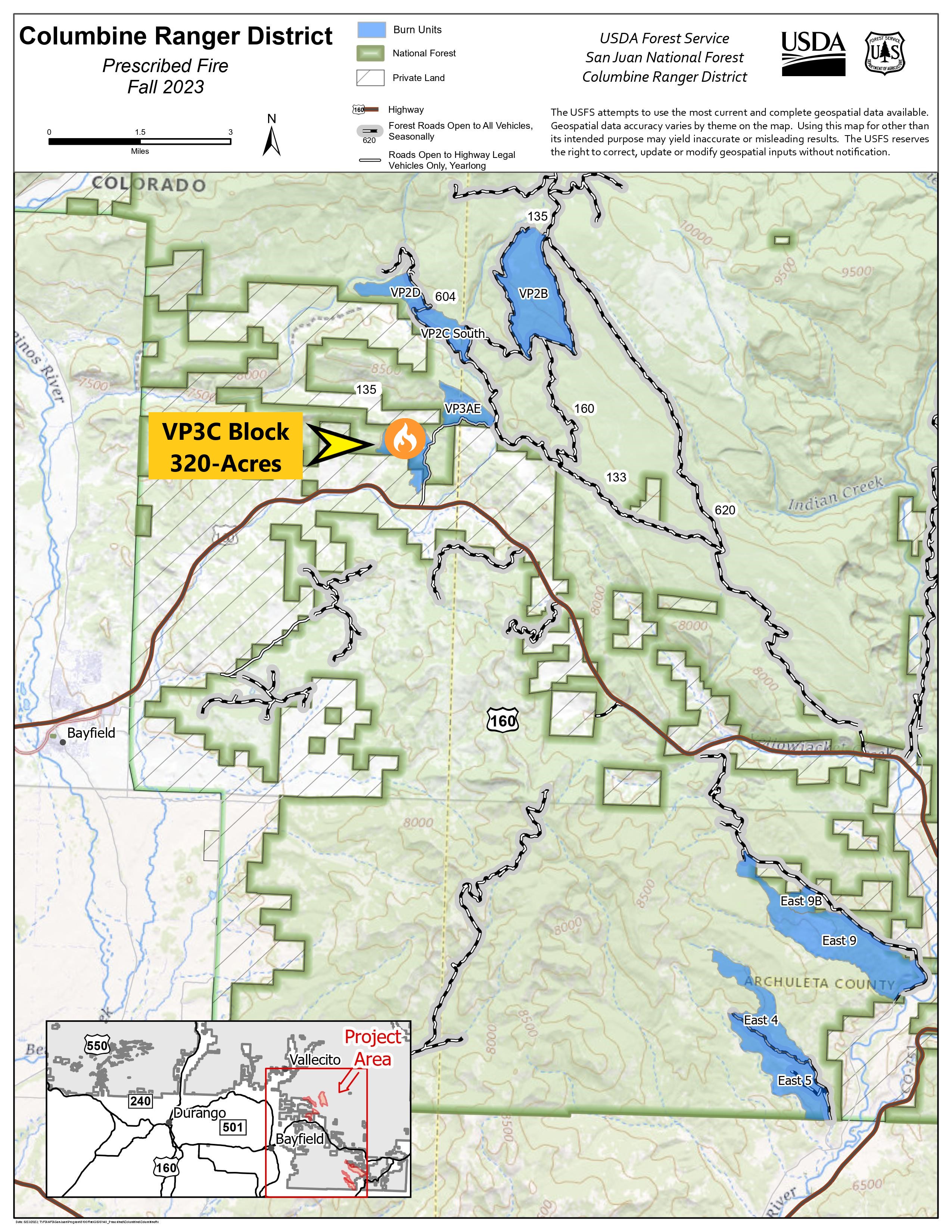
Columbine District VallecitoPiedra Unit Prescribed Fire VP3C Block 09262023
Related Incident: 2025 San Juan National Forest Prescribed Fire Program
Publication Type: News
The USDA Forest Service - San Juan National Forest, Columbine Ranger District, is conducting several prescribed burns in the Vallecito/Piedra Unit starting today, September 26th. Burning operations will take place over multiple days when weather and fuel conditions are favorable for ignition.
Ignitions have begun on the Vallecito/Piedra Unit-Bock 2. The 320-acre prescribed burning operation will take place north of HWY-160. If you are in the area, please exercise caution as firefighters and firefighting apparatuses will be actively working and patrolling the area. Some smoke may be visible.
Prescribed fire is necessary to improve and restore native vegetative conditions. This effort will reduce hazardous ground fuels, lessen the risk of unplanned large-scale wildfire, help restore ponderosa pine ecosystems and improve wildlife habitat.
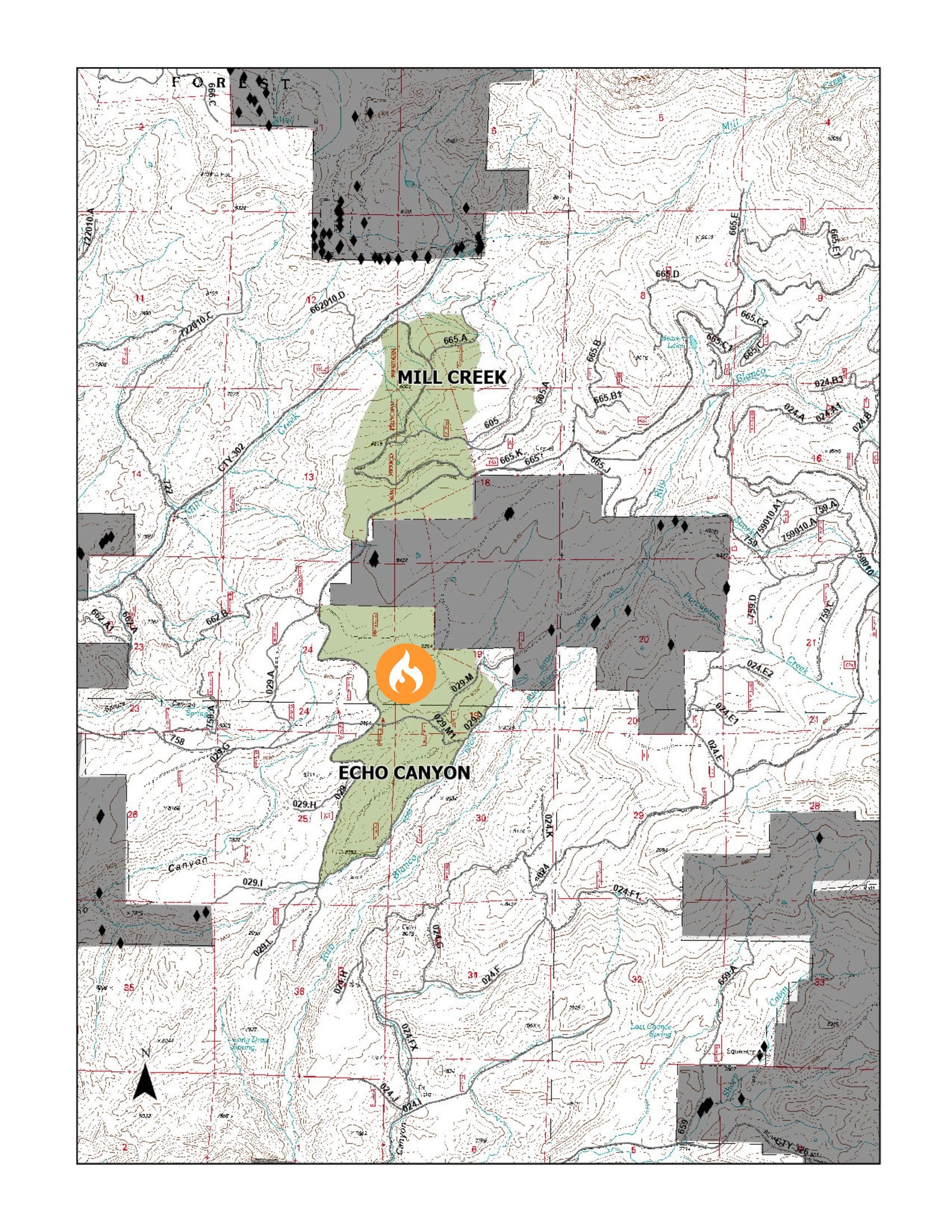
Pagosa Ranger DistrictEcho Canyon UnitPrescribed Fire 9262023
Related Incident: 2025 San Juan National Forest Prescribed Fire Program
Publication Type: News
Ignitions for the prescribed burning operation will continue today, September 26th, 2023, at 11am on the Echo Canyon Unit within the Pagosa Ranger District, USDA Forest Service - San Juan National Forest. Today's operation is located west of Rito Blanco Ranch on the southern end of the #SanJuanNF. Resources have scheduled to burn block 2 with the possibility of continuing on with block 3 of the Echo Canyon Unit. Crews are looking for a total burn goal of 450-acres.
Seventy firefighters will work to execute this prescribed fire, aimed at reducing hazardous ground fuels, reducing the risk of unplanned catastrophic wildfire, restoring ponderosa pine ecosystems, and improving wildlife habitat.
If you are in the area, please exercise extreme caution when around firefighters and fire apparatuses. Some smoke may be visible in the area.
Actualizacin del Incendio del Complejo Cowlitz 26 de septiembre de 2023
Related Incident: Cowlitz Complex
Publication Type: News
26 de septiembre de 2023
Bomberos siguen trabajando a pesar de las fuertes lluvias en el Complejo Cowlitz
(RANDLE, Wash.) – El Complejo Cowlitz está contenido en un 39% con un total de 731 acres quemados.
Actualmente hay 174 recursos asignados al Complejo Cowlitz. El fuego sigue ardiendo en algunas zonas, pero no se han detectado nuevos focos de calor Los bomberos seguirán trabajando en la reparación de extinción de incendios como puedan, como la construcción de barras de agua y la dispersión de la maleza. Los responsables del incendio están decidiendo qué equipos pueden desmovilizar y liberar del incidente. Deben tomarse precauciones para garantizar que las cuadrillas puedan trabajar con seguridad con tiempo húmedo en carreteras resbaladizas para recuperar el equipo que ya no se necesita. Las aeronaves están siendo liberadas ya que el tiempo no es propicio para volar. El Comandante de Incidentes Kent Stanford aconseja a los equipos "Estar seguros. Sean deliberados".
El tiempo: El tiempo húmedo continuará durante gran parte de la semana. La probabilidad de precipitaciones mensurables es del 100% el martes, con lluvias moderadas más constantes desde media tarde del martes hasta la mañana del miércoles. Tras unas mínimas matinales de 45-50 grados, las temperaturas del martes por la tarde subirán a 46-56 grados. Los vientos soplarán del sur a 3-8 mph en gran parte de la zona, mientras que soplarán a 8-16 mph con rachas cercanas a 25 mph en las crestas expuestas.
Mensaje de seguridad: Con las fuertes lluvias, la visibilidad es reducida. Recientemente se han avistado alces cerca de la carretera 12. Viaje más despacio y tenga cuidado al conducir, incluso en carreteras pavimentadas.
Antecedentes: Hubo 30 incendios en el complejo. Los incendios se iniciaron el 25 de agosto tras un rayo en el bosque nacional de Gifford Pinchot. La mayoría han sido contenidos y se encuentran en estado de patrulla o vigilancia mientras continúan las reparaciones de supresión.
Cierres: Debido a las actividades de los incendios en curso, las siguientes carreteras y senderos están cerrados al público para ayudar a garantizar la seguridad pública y de los bomberos: Carreteras forestales 25, 9300 y 9341, Boundary Trail #1 (desde Elk Pass hasta la intersección con Summit Prairie), Summit Prairie #2, Craggy Peak #3, Snagtooth #4, Quartz #5, Stabler Camp 17, Wright Meadows #80, Basin Camp #3A, Quartz #5B (French Creek), Snyder Pasture #80A.
Restricciones Temporales de Vuelo: El TFR se reduce a una sola área que abarca un radio de 5 millas al este de Randle. El TFR está en vigor durante las horas diurnas para incluir el apoyo al incendio de Grassy Mountain. La respuesta de la aviación contra incendios se detiene o retrasa si una aeronave no autorizada entra en el TFR. Las restricciones temporales de vuelo también se aplican a las aeronaves no tripuladas o drones. Para más información: https://tfr.faa.gov/save_pages/detail_3_3758.html
###
Cowlitz Complex Daily Update September 26 2023
Related Incident: Cowlitz Complex
Publication Type: News
September 26, 2023
Firefighters Continue Working Despite Heavy Rain at Cowlitz Complex
(RANDLE, Wash.) – The Cowlitz Complex is 39% contained with a total of 731 acres burned.
There are currently 174 resources assigned to the Cowlitz Complex. The fire is still smoldering in some areas, but there have been no new pockets of heat detected Firefighters will continue to work on fire suppression repair as they can, such as constructing water bars and scattering brush. Fire managers are deciding which equipment they can demobilize and release from the incident. Caution must be taken to ensure crews can work safely in wet weather on slippery roads to retrieve equipment that is no longer needed. Aircraft is being released as the weather is not conducive for flying. Incident Commander Kent Stanford advises crews to “Be safe. Be deliberate.”
Weather: Wet weather will continue through much of the week. The chance of measurable rainfall is 100 percent Tuesday, with more steady moderate rain from mid-afternoon Tuesday into Wednesday morning. After morning lows of 45-50 degrees, temperatures Tuesday afternoon will rise to 46-56 degrees. Winds will be out of the south 3-8 mph over much of the area, while 8-16 mph with gusts near 25 mph over exposed ridges.
Safety Message: With heavy rain, visibility is impaired. Elk have been spotted near Highway 12 recently. Travel slower and use caution when driving, even on paved roads.
Background: There were 30 fires in the complex. The fires started August 25th after a lightning event across the Gifford Pinchot National Forest. Most have been contained and are in patrol or monitor status as suppression repair continues.
Closures: Due to ongoing fire activities, the following roads and trails are closed to the public to help ensure public and firefighter safety: Forest Roads 25, 9300 and 9341, Boundary Trail #1 (from Elk Pass to intersection with Summit Prairie), Summit Prairie #2, Craggy Peak #3, Snagtooth #4, Quartz #5, Stabler Camp 17, Wright Meadows #80, Basin Camp #3A, Quartz #5B (French Creek), Snyder Pasture #80A.
Temporary Flight Restrictions: The TFR is reduced to one single area encompassing a 5-mile radius east of Randle. The TFR is in effect during daylight hours to include support for the Grassy Mountain Fire. Fire aviation response is halted or delayed if an unauthorized aircraft enters the TFR. Temporary flight restrictions also apply to unmanned aircraft or drones. For more information: https://tfr.faa.gov/save_pages/detail_3_3758.html
###
2023 SRF Lightning Complex Update September 26 2023
Related Incident: 2023 SRF Lightning Complex and Redwood Lightning Complex
Publication Type: News
Fire Update
2023 SRF Lightning Complex
Tuesday, September 26, 2023 – 9:00 a.m.
Eastern Area Gold Team
Brian Jenkins, Incident Commander
Information Phone: 530-536-0767
Email: 2023.lightningcomplex@firenet.gov
Information Staffing Hours: 8 am to 8 pm
This update covers 5 of the 14 fires being managed as part of the SRF Lightning Complex. The Copper Fire (2184 acres) was absorbed by the Blue Creek #2 Fire. On September 22, 2023, the Bluff #1 Fire (4270 acres) and Blue Creek #2 Fire (9751 acres) were absorbed by the Mosquito Fire. The combination of Blue Creek #2 Fire, Bluff #1 Fire, and Mosquito Fire is now referred to as the Mosquito Fire. The remaining 6 fires (Big Foot, Blue Creek, Creek, Flat, Iron, and Merrill) totaling 34 acres, are contained and in patrol status. They are checked daily, and their size and containment are unlikely to change.
Current Situation: The 14 fires on this incident total 42,517 acres and overall containment is 8%. Due to cloud cover over the past couple of days we have not been able to complete an infrared flight to update the fire size. In total, 683 personnel are assigned to the incident. Yesterday, the predicted rainfall and cooler weather moved into the area and subdued fire activity. The weather conditions also increased the potential hazards of fire weakened trees falling without warning on all parts of the fires due to winds and wet soil conditions. The possibility of additional rocks and debris falling from steep slopes on to the roadways remains a concern with the amount of precipitation that has fallen. These conditions will continue to be monitored along Highway 96 and the Salmon River Road throughout the day. The night shift of firefighters ended on Sunday night due to decreased fire activity and the increased risk of exposure to hazards such as rocks and fire weakened trees falling without notice. When conditions dry out the fire activity will determine whether a night shift is needed again.
The plan for today will be for crews and equipment to move slowly and deliberately from the Fire Camp and back out to the fire area as weather and road conditions allow. It will take some time to allow the road system to dry out from the rain that has fallen. Fire weakened trees with root systems affected by wet soils have created hazardous conditions that fire crews will need to assess and mitigate before reengaging on the fire control lines. It may not be possible to get engines and equipment into certain areas until some drying conditions occur. Firefighters will assess the conditions and monitor the fire following the rain event. The rain that has fallen is being characterized as a season slowing event for fire activity.
Pearch Fire (11,131 acres, 6% contained) – The rain was delayed by a few hours yesterday which allowed the crews to monitor the fire area in the morning. Minimal fire activity was observed. There were small amounts of rocks and debris that fell on both the Salmon River Road and Highway 96 throughout the day. CalTrans and Siskiyou County crews and equipment remain available to clear the rocks and debris as needed. The crews staged on or near Highway 96 when the heavy rain started falling during the day. The amounts of debris falling onto the road is expected to continue because of the precipitation. Please continue to drive with caution and consider alternate routes.
An Evacuation Warning remains in place for those residents in the Butler Creek area (SIS-1704) which means persons in the area need to be prepared to evacuate if conditions warrant.
Mosquito Fire (29,266 acres, 6% contained) – Increased fire activity happened on Sunday afternoon, but cloudy conditions and rainfall subdued the activity yesterday. Crews attempted to check on fire growth in the Rock Creek area however, they were unable to provide an estimate on the increase in size. As the winds and rain started most of the crews and equipment staged at the Base Camp due to muddy and unstable road conditions. Some crews were able to shelter in place on the east side of the fire where safe to do so.
Marlow Fire (1,988 acres, 0% contained) – There continued to be minimal activity on the Marlow Fire. This fire is in a remote area and is bounded by indirect control lines to the east and south and prior fire footprints where fuels are lighter. No values are threatened by the Marlow Fire.
Monument (2 acres, 0% contained) and Let er-Buck (96 acres, 0% contained) Fires – A confinement strategy is being used to address these two fires due to limited values at risk and the remote, steep terrain with associated safety concerns for the firefighters. Terrain, natural fire barriers such as rock outcroppings, and old fire footprints where fuels are limited will be used to confine fire growth until season ending precipitation extinguishes the fires. These fires are checked regularly by aerial patrols to ensure they remain within acceptable bounds.
Weather: Yesterday, the large low-pressure system brought widespread rainfall across the fire area. Throughout the day portions of the fire received anywhere from 2 inches of rain in the lower elevations to 4 inches of rain in the higher elevations. Today, the weather is expected to be mostly cloudy with scattered rain showers. Temperatures will range from 65 to 70 degrees in the valleys to 79 to 84 degrees on the slopes and ridges. Humidity levels will be as low as 45 to 55 percent. Winds will be from the southwest at 10 to 15 mph. The chance of rain will continue to be around 60 percent.
Evacuation Information
Siskiyou County Office of Emergency Services: https://www.co.siskiyou.ca.us/emergencyservices
Closures
Six Rivers National Forest: Area and campground closures are in effect on portions of Six Rivers National Forest. They can be found at: https://www.fs.usda.gov/detail/srnf/notices/?cid=FSEPRD1096395.
Additional Fire Information
Facebook: https://www.facebook.com/2023SRFRedwoodLightning
More Fire Information Links: www.linktr.ee/srffirepio
For Air Quality Information: www.airnow.gov
NOTE: For information about the Elliot or Hancock Fires which are part of the
Happy Camp Complex, please visit https://linktr.ee/happycampcomplex2023 .