
Thursday September 28 2023 Valentine fire update and map
Related Incident:
Publication Type: News
Size: 9,015 acres
Start Date: August 16, 2023
Cause: Lightning
Completion: 95%
Total personnel: 200
Location: 11 miles northeast of Young, Arizona and 27 miles
east of Payson, Arizona
Fuels: Ponderosa Pine, Hardwood litter and timber
Highlights: Crews are working to secure the southwest corner of the fire perimeter and increase interior depth prior to the arrival of strong winds over the weekend.
Operations: Wednesday, crews held the perimeter of the fire along FSRD 411 to Lost Salt Canyon and FSRD 200 while other crews cleared snags along FSRD 778. Pumps and hose lines were set up in Haigler Creek to help secure the south-central containment line where there is no road access. Today, aerial and hand ignitions will continue to bring the fire line downslope towards Haigler Creek and FSRD 848. Crews will be patrolling and holding established containment lines throughout the day.
Fire Ecology: Wildlife is rarely killed directly by fire, though uncharacteristically severe fire may cause significant damage to wildlife habitat. Animals that are most vulnerable to fire are those with limited mobility, live above ground and/or are nesting or young when the fire goes through an area. Slower moving fires, like the Valentine, can allow enough time for wildlife to react to the fire, and they often return to the recently burned areas soon after the fire is done burning to take advantage of the new growth.
Weather: Wednesday, temperatures were cooler with an inversion in the morning and light winds. Today, expect high clouds with a slight cool down and sunny in late afternoon as the clouds disperse. Winds are expected to be the same today as yesterday.
Closures: An emergency closure order for the Valentine Fire has gone into effect as of 6 a.m. Sept. 5, 2023. The public is asked to avoid the fire area. The purpose of the closure order is to protect public health and safety during the Valentine Fire, and to protect assigned firefighting personnel engaging in wildland firefighting operations. Signs and gates will be in place to remind the public not to enter the fire area. Please visit the Alerts and Notices page for more information. https://www.fs.usda.gov/alerts/tonto/alerts-notices.
Safety: The health and safety of firefighters, and the public are always the highest priority. Members of the public are asked to avoid the fire area.
Smoke: The fire will produce considerable amounts of smoke due to excessive fuel accumulation. Smoke from the Valentine Fire may be visible in the surrounding areas for many days. Smoke-sensitive individuals and people with respiratory problems or heart disease are encouraged to take precautionary measures. An interactive smoke map available at, https://www.airnow.gov/wildfires/ allows you to zoom into your area to see the latest smoke conditions.
![]()
Information Links and Contacts:
Tonto National Forest https://www.fs.usda.gov/main/tonto/fire
InciWeb https://inciweb.nwcg.gov/incident-information/aztnf-valentine-fire Fire Email 2023.valentine@firenet.gov
South Fork Complex Update September 28 2023
Related Incident: South Fork Complex
Publication Type: News
South Fork Complex Update
Thursday, September 28, 2023
Fire Information: 707-572-7325, 8 a.m. to 5 p.m.
Email: 2023.southforkcomplex@firenet.gov
Linktree: https://linktr.ee/2023southforkcomplex
This will be the last update unless significant changes occur.
3-9 Fire: 2,840 acres with 85% containment
Pellitreau Fire: 3 acres with 100% containment
Pilot Fire: 1,055 acres with 100% containment
Sulphur Fire: 31 acres with 100% containment
3,929 acres and 90% overall containment for the South Fork Complex
A total of 149 personnel, crews, air support, engines, dozers, and water tenders support the incident.
A new flight over the fire areas using infrared to find heat sources occurred in the evening of 9/26/2023. The storm event was not sufficient to fully suppress interior heat sources such as burning stumps and root systems underground. Crews continue to patrol the fire perimeters and work to complete suppression repair.
3-9 Fire –Heavy equipment and crews are fully engaged with chipping operations along Route 1. The public can expect to see large dump trucks transporting the chips along Route 1 and Highway 36.
Weather: 7 Day Outlook:
Thursday: Sunny. Highs 55-65. Min RH 40-60%. Winds light and variable becoming northwest 5 to 10 mph with gusts around 17 mph in the afternoon.
Friday: Partly Cloudy. A slight (20%) chance of afternoon showers. Highs 53-63. Min RH 50-70%. Winds light and variable becoming north-northwest 8 to 12 mph with gusts around 18 mph in the afternoon.
Saturday: Sunny. Highs 55-65. Min RH 35-55%. Winds northwest 6 to 12 mph with gusts around 18 mph.
Sunday: Sunny. Highs 57-67. Min RH 30-50%. Winds light and variable becoming north-northwest 5 to 10 mph with gusts to 17 mph in the afternoon.
Monday: Partly cloudy. Highs 59-69. Min RH 35-55%. Winds west-northwest 5 to 10 mph with gusts around 17 mph.
Tuesday: Sunny. Highs 62-72. Min RH 40-60%. Winds light and variable becoming west-northwest 5 to 10 mph in the afternoon.
Wednesday: Sunny. Highs 64-74. Min RH 35-55%. Winds light and variable becoming west-northwest 5 to 10 mph in the afternoon.
Forest Closure: Forest Closure Order for the South Fork Complex Fire continues to be in effect and is posted on the Six Rivers National Forest website. Please avoid closed areas.
@U.S. Forest Service - Shasta-Trinity National Forest
@U.S. Forest Service - Six Rivers National Forest
PM Update 9272023
Related Incident: Cow Creek Prescribed Burn
Publication Type: Announcement
Work is completed for today, Wednesday, Sept. 27, on the #CowCreekRx Prescribed Burn area located approximately 9 miles east of Gateway, Colorado, and 25 miles southwest of Grand Junction, Colorado. Firefighters spent the day securing the perimeter and completing work on Unit 1 of this prescribed burn plan.
Smoke may be visible in the Gateway and Grand Junction areas. The public is advised not to call 911 for smoke related to this prescribed burn.
Starting tomorrow, Thursday, Sept. 28, this area of the GMUG may begin to experience higher winds. These winds will likely disperse the smoke resulting from this burn, while also increasing smoke production from residual hot areas within the perimeter of this burn area. Firefighters will continue to monitor the Cow Creek Prescribed Burn area during this period of increasing winds and are not planning on further ignitions during the wind event.
Moving forward, the GMUG will be monitoring for a return of favorable prescribed burning conditions for Unit 2 (see map below) for the #CowCreekRx burn.
For more information on how prescribed fire smoke may affect your health, please visit https://www.colorado.gov/pacific/cdphe/wood-smoke-and-health
Prescription (RX) burning is important to maintain a fire-adapted ecosystem and is essential for wildfire prevention. For more information on prescription burning and its use, please visit: https://www.fs.usda.gov/managing-land/prescribed-fire
Daily Fire Update September 27
Related Incident: Hope Fire
Publication Type: News
Fact Sheet for the Hope Fire - September 27, 2023
The Hope Fire was lightning-caused and detected on September 21st. The fire is being managed under a full suppression strategy by local resources from the Dolores Ranger District of the San Juan National Forest. It is currently burning at Hoppe Point located northwest of the McPhee Dam and Reservoir, east of Bradfield Campground.
The location of the fire is within the boundaries of a prescribed fire burn unit. Fire personnel have been working to prepare lines around the estimated 3,000-acre section. Firefighters are reinforcing and using previously defined and prepared control lines to allow this naturally caused wildfire to reduce forest fuels and improve forest health within those boundaries. This will decrease risk of future catastrophic wildfire, protect infrastructure and private lands, and improve forage for wildlife.
Current
- A Type 3 Incident Management Team will assume command of the Hope Fire today to better manage the complexity of the upcoming operational period.
- A planned firing operation to aid in suppression efforts is planned for today. The public will likely see increased smoke.
- The fire continues to creep and smolder within the burn perimeter.
- Firefighters continue to reinforce containment lines around the planning area to support fire suppression efforts.
Outlook
- The weather will be dry and mild through Thursday.
- Firefighters will look for opportunities to reinforce control lines through Thursday as weather permits.
- Increased winds are forecast for the fire area this weekend.
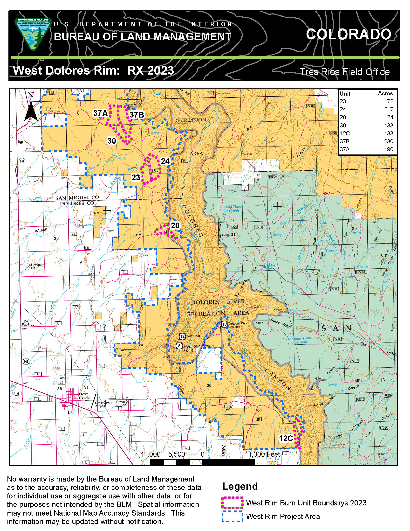
West Dolores Rim prescribed burn completes 400 acres September 27 2023
Related Incident:
Publication Type: Announcement
Today, fire resources on the West Dolores Rim prescribed burn successfully completed units 23 and 24 for a total of 400 acres. This was a second entry burn surrounded by units that have recently been treated. Firefighters will remain in the area through the weekend. Light smoke may be visible east of Egnar, CO.
For more information on BLM Southwest District prescribed burn treatments visit, InciWeb-Southwest District BLM Prescribed Fire https://inciweb.wildfire.gov/ and follow BLM Southwest District Facebook and Twitter @SWD_Fire
Informacin actual para los incendios Anvil y Flat 27 de septiembre 2023
Related Incident: Flat FireAnvil Fire
Publication Type: News
Incendio Anvil
Área: 21,842 acres Fecha de Inicio: 25 de agosto, 2023 Localizado: 8 millas Este de Port Orford, OR
Contención: 27% Personal: 1,144
Recursos: 32 escuadrillas de bomberos, 10 helicópteros, 46 camiones de bomberos
A las 7:00 de la mañana del hoy, el Grupo 4, Great Basin, transfirió el comando de los incendios Anvil and Flat al Grupo 1, Southwest.
El día de ayer, las escuadrillas de bomberos se enfocaron en ganar mas acceso dentro del incendio. Los bomberos se dedicaron a evaluar el impacto causado por la lluvia y continuaron progresando en el refuerzo de las líneas alternativas y de control. De esta manera, lograron realizar ciertos avances adicionales sobre el eje Norte, alcanzando un 27% de contención en el incendio. el día de hoy, los bomberos continuaran limpiando los deslizamientos del suelo y árboles caídos sobre el camino, con el objetivo de restablecer el acceso al área del incendio. Es una prioridad la construcción de líneas primarias de contención del fuego, enfatizándose en la esquina Norte, en donde las llamas lograron cruzar la bifurcación Sur de Sixes River. A pesar de que la lluvia se extendió sobre toda la zona, esta no fue suficiente para contener el Incendio Anvil en su totalidad. Se seguirá observando actividad en el incendio en las próximas semanas, hasta que se presenten lluvias consistentes o cierta cantidad de nieve que logren cubrir el área afectada. El fuego continuara quemándose lentamente en la vegetación alta y árboles caídos hasta que baje el nivel de humedad y el grado de temperaturas se caliente lo suficiente para permitir que las llamas empiecen a quemarse más activamente.
Evacuaciones: La Oficina del Alguacil para el Condado de curry, ha identificado cuatro zonas de evacuación alrededor del incendio Anvil. En horas de la tarde del lunes, el Alguacil logro reducir los Niveles de Evacuación. Zonas 1, 2 y 4 se encuentran en un Nivel 2 “LISTOS”. Los residentes podrán regresar a sus viviendas, pero deberán estar preparados para ser evacuados en caso de darse un incremento en el incendio. La Zona 3 ahora se encuentra en un Nivel 1 “PREPARESE”. La comunidad deberá estar atenta para los cambios en las condiciones hasta que se considere que el incendio ha sido contenido en su totalidad y las evacuaciones puedan ser levantadas completamente. Para revisar un mapa interactivo de evacuación, visite: https://bit.ly/45UIh2E. Puede registrarse en el sistema de Alertas de emergencias para el condado: https://bit.ly/CurryCoEM.
Ordenes de Cierres para ciertas áreas y carreteras: Para la seguridad de los bomberos y para el público en general, el Bosque Nacional de Rogue River-Siskiyou (RRSNF)y la Agencia para el Manejo de Tierras en el distrito de Coos Bay, han dictado una orden de cierre para el Incendio Anvil. Puede encontrar mapas e información más detallada en: https://inciweb.wildfire.gov/incident-closures/orrsf-anvil-fire.
Restricciones: El 27 de septiembre, 2023 a las 12:01 a.m., el Bosque Nacional de Rogue River Siskiyou, cambio el nivel de peligro de incendios a “Moderado” y redujo el Nivel de Precaución de Incendios a Nivel 1. Se levantaron todas las restricciones de Uso Público en la sección silvestre de Rogue River.
Incendio Flat
Área: 34,242 acres Inicio: 15 de julio, 2023 Localizado: 2 millas Sureste de Agness, OR
Contención: 75% Personal: 11 Recursos: 3 camiones de bomberos
Permanece en efecto la Orden de Cierre para el Bosque nacional de Rogue River-Siskiyou. Información al día: https://bit.ly/RRSNFAlerts
Información General
Condiciones climáticas: Una alta cantidad de lluvia se dio en ambos incendios en las últimas 36 horas. Por el momento, algunas áreas han registrado hasta 5”. Las lluvias proseguirán el día de hoy con un total pronosticado de otros 1/4” de precipitación. Los vientos cambiaran a brisas con rumbo Oeste. Las lluvias decrecerán por la tarde, pero existe la posibilidad de observarse múltiples lluvias ligeras hasta el viernes. Durante el fin de semana, se dará una tendencia seca y las temperaturas podrían empezar a incrementarse ligeramente.
Condiciones del humo: Se podrá incrementar la presencia del humo para los próximos días debido a la materia de combustión secándose y por el incremento en la actividad del incendio. Para información al día en la presencia del humo y la calidad del aire, visite: https://bit.ly/SWORsmoke. Caltrans ha publicado un horario del cierre de carreteras y restricciones en las líneas de tráfico, para el Hwy. US 199. Las autoridades locales recomiendan no utilizar esta ruta si no es realmente necesario. Para encontrar información específica en el acceso de carreteras, por favor lea el sitio de Caltrans QuickMap en: https://quickmap.dot.ca.gov/ y también el sitio de Oregon Department of Transportation site en: https://www.tripcheck.com/. No utilize las carreteras forestales como una ruta alternativa.
Contact Fire Information: (541) 216-4579 or (541) 237-6369
Email: 2023.anvil@firenet.gov
Facebook: facebook.com/flatfireoregon2023
X/Twitter: twitter.com/RRSNF
Inciweb Anvil Fire: bit.ly/AnvilFireOR
Inciweb Flat Fire: bit.ly/FlatFireOR
Anvil and Flat Fires Update September 27 2023
Related Incident: Flat FireAnvil Fire
Publication Type: News
Anvil Fire
Size: 21,842 acres Start Date: August 25, 2023 Location: 8 miles east of Port Orford, OR
Containment: 27% Total personnel: 1,144 Resources: 32 crews, 10 helicopters, 46 engines
At 7:00 a.m. today, Great Basin Team 4 transferred command of the Anvil and Flat Fires to Southwest Team 1. Yesterday, fire crews focused on gaining access to the fires. On the Anvil Fire, firefighters assessed impacts from the rain and continued to make progress bolstering containment and alternate lines. Containment increased to 27% as crews made additional progress on the north end of the fire.
Today, crews will continue cleaning up landslides and downed trees that are impacting roads to reestablish access to the fire area. Constructing primary fire containment lines is the first priority, with an emphasis on the northeast corner of the fire, where the fire has crossed the South Fork Sixes River. The rain, although widespread, is not enough to fully contain the Anvil Fire. Expect to see continued fire activity over the coming weeks, until ongoing, consistent rain or snow covers the fire area. It will continue to smolder in heavy vegetation and downed timber until humidity drops and temperatures warm enough to allow flames to burn more actively again.
Evacuations: Curry County Sheriff’s Office has identified four evacuation zones around the Anvil Fire. On Monday afternoon, the Sheriff was able to reduce the evacuation levels. Zones 1, 2, and 4 are now in Level 2 “Be Set” status. Residents may return home but should be prepared to evacuate should fire activity increase again. Zone 3 is now in Level 1 “Ready” status. All residents should remain attentive to changing conditions until the fire is more fully contained and the evacuations can be lifted completely. View the interactive evacuation map at https://bit.ly/AnvilEvacs. Sign up for Curry Co. emergency alerts at https://bit.ly/CurryCoEM.
Area and Road Closures: For the safety of firefighters and the public, the Rogue River-Siskiyou National Forest (RRSNF) and Coos Bay District Bureau of Land Management have issued closure orders for the Anvil Fire area. Find maps and closure information at https://inciweb.wildfire.gov/incident-closures/orrsf-anvil-fire.
Fire Restrictions: On Sept. 27 at 12:01 am, The Rogue River Siskiyou National Forest has moved to “moderate” fire danger and Industrial Fire Precaution Level was reduced to Level 1. All Public Use Restrictions on the Wild Section of the Rogue River have been lifted.
Flat Fire
Size: 34,242 acres Start Date: July 15, 2023 Location: 2 miles southeast of Agness, OR Containment: 75% Total personnel: 11 Resources: 3 engines
The RRSNF closure on the Flat Fire remains in effect: https://bit.ly/RRSNFAlerts
General Information
Weather: Heavy rain fell over both fires in the past 36 hours. Some areas recorded more than 5” so far. Isolated showers will continue today with up to another ¼ - 1” forecast. Winds will shift to westerly breezes. By the weekend, the trend will dry out and temperatures may begin to climb slightly.
Smoke: Smoke may being to increase in the coming days as fuels dry out and fire activity increases. Visit https://bit.ly/SWORsmoke for current smoke and air quality updates. Please drive slowly and with headlights on through any fire area. Caltrans issued a schedule of road closures and lane restrictions on US-199 northeast from Crescent City. Local law enforcement cautions against any non-essential traffic along this route. For specific information on road access, please see the Caltrans QuickMap site, https://quickmap.dot.ca.gov/ and Oregon Department of Transportation site, https://www.tripcheck.com/. Do not use forest roads for alternate routes.
Contact Fire Information: (541) 216-4579 or (541) 237-6369
Email: 2023.anvil@firenet.gov
Facebook: facebook.com/flatfireoregon2023
X/Twitter: twitter.com/RRSNF
Inciweb Anvil Fire: bit.ly/AnvilFireOR
Inciweb Flat Fire: bit.ly/FlatFireOR
Deschutes National Forest rescinds closure for Petes Lake Fire
Related Incident: Petes Lake Fire
Publication Type: Announcement
Deschutes National Forest rescinds closure for Petes Lake Fire
Bend, Ore. – Effective Wednesday, September 27, the Deschutes National Forest will rescind the temporary Forest Closure Order (06-18-01-23-26) for the Petes Lake Fire.
The closure began on September 19 and encompassed all Deschutes National Forest managed lands including Horse Lake Trail, Island Meadow Trail, Pacific Crest National Scenic Trail - Irish Mtn., Pacific Crest National Scenic Trail - Maiden Peak, Pacific Crest National Scenic Trail - Three Sister, Senoj Lake Trail #14.1, Six Lakes Trail, Six Lakes Trailhead, Snowshoe Lakes Trail, Winopee Lake Trail, Winopee Tie Trail, Winopee Trailhead, and Elk Lake Trailhead. All of these areas, including the Wanoga Sno-Park are now open to the public.
A portion of the Pacific Crest Trail was burned over by the Petes Lake Fire and the public is reminded to use caution through fire-impacted areas.
The Petes Lake Fire remains on the Willamette National Forest and forecasted wetter and colder weather conditions are expected to keep fire activity minimal until a season ending event fully extinguishes hot spots.
The Petes Lake Fire was started by lighting on August 25, 2023. The fire is now 3,254 acres and 50% of the indirect suppression measures (e.g. the shaded fuel break, roadside mastication and brushing) has been completed at this time. The use of indirect suppression strategizes minimizes risk to firefighters, while offering containment options for this and future fires.
Public Use Restrictions Lifted Across the Rogue RiverSiskiyou National Forest
Related Incident: Flat FireAnvil Fire
Publication Type: Announcement
Public Use Restrictions Lifted Across the Rogue River-Siskiyou National Forest
Medford, Ore-September 27, 2023 - Recent rains and lower temperatures across the Rogue River-Siskiyou National Forest (RRSNF) have prompted the lifting of all Public Use Restrictions on the forest, effective tomorrow, September 27th at 12:01 a.m..
The forest will move to "moderate" fire danger on all five Ranger Districts.
The Industrial Fire Precaution Level will be reduced to Level 1.
For up-to-date information regarding fire season, ongoing fires, and fire restrictions, follow the RRSNF on Twitter and Facebook.
Further information regarding fire danger and fire statistics to date on the RRSNF can be found on the RRSNF's Fire Management Page.
-end-
Smith River Complex South Daily Update September 27 2023
Related Incident: Smith River Complex
Publication Type: News
CURRENT SITUATION: Crews have been closely monitoring the Smith River Fire as they anticipated rainfall on Monday.
Today, they have returned to assess the impact of the rain on the fire. While there has been a change in management, the primary objectives of ensuring life safety, continued fire suppression efforts, and initiating suppression recovery activities remain unchanged. Incident Management Team 4 has transferred command to Incident Management Team 12. This transition was made following thorough meetings, shadowing, and briefings of Team 12 by Team 4. Effective today, Team 12 assumes command of the Smith River Complex. Minimal fire activity is expected along the fire line. The recent rain has helped in dampening the fire's spread, reducing the immediate threat.
Crews will be conducting regular patrols along the fire line to ensure that any remaining hotspots or smoldering areas are promptly identified and addressed. Continuous monitoring of the fire's behavior and its potential to flare up will be a top priority to prevent any spread outside containment lines. Efforts to repair and rehabilitate areas where fire crews created fire breaks will commence. This includes mitigating the environmental impact caused during normal firefighting operations. Residents and visitors are urged to remain vigilant and stay informed about the latest updates from local authorities. While the immediate threat may have diminished, it is crucial to adhere to any safety instructions and be prepared for any unforeseen changes in fire behavior. Firefighter and public safety remain paramount in managing this incident. Your safety is our top priority, and we appreciate your cooperation and support during this challenging time. Updates will be issued every other day from this time (9/27/2023) forward.
WEATHER: Weather over the fire area today will be mostly cloudy with rain expected to taper off in the morning, then isolated showers in the afternoon. Temperatures in the valleys will range from a high of 60°-65° with ridgetop temperatures in the mid to high 50’s. Relative humidity values will range from 71-78% in valleys to 76-83% along ridgetops. Winds are anticipated out of the northwest 4-7mph in the valleys, and 7-12mph along ridgetops. The extended outlook shows a weak weather system moving through the area until Friday with cooler than normal temperatures, and a 20-40% of showers.
EVACUATIONS: All evacuations have been lifted. For continuous updates, view the interactive evacuation map online tinyurl.com/29vv2wpm.
CLOSURES: US 199 in Del Norte County will be fully closed twice daily, Monday through Friday, from 8 AM to 11 AM and from 1 PM to 4 PM. During all open hours, traffic will be one-way and piloted between Grassy Flat Campground east of Gasquet and Oregon Mountain Road. Motorists should anticipate delays during all open hours. Caltrans provides information on current highway conditions online (roads.dot.ca.gov), by phone (800-427-7623), and on Facebook (facebook.com/CaltransD1).
Six Rivers National Forest lands, roads, and trails around the Smith River Complex fires are closed (Forest Order No. 10- 23-08). View the Order, closure map, and day use exceptions on the Forest’s website: tinyurl.com/4atens8c.