
South Fork Complex Update September 25 2023
Related Incident: South Fork Complex
Publication Type: News
South Fork Complex Update
Monday, September 25, 2023
Fire Information: 916-261-6756, 8 a.m. to 8 p.m.
Email: 2023.southforkcomplex@firenet.gov
Linktree: https://linktr.ee/2023southforkcomplex
3-9 Fire: 2,840 acres with 85% containment
Pellitreau Fire: 3 acres with 100% containment
Pilot Fire: 1,055 acres with 100% containment
Sulphur Fire: 31 acres with 100% containment
3,929 acres and 90% overall containment for the South Fork Complex
A total of 181 personnel, crews, air support, engines, dozers, and water tenders support the incident.
3-9 Fire – Crews are wrapping up repair activities. Operations to fall snags and hazardous trees continue. Engines are monitoring the interior smoke and heat. United States Forest Service Resource Advisors (READs) are monitoring these activities, and addressing any potential concerns to tribal, cultural, and natural resources. Heavy equipment and crews are engaged with chipping operations along Route 1. The public can expect to see large dump trucks transporting the chips along Route 1 and Highway 36.
The Pilot Fire is 100% contained. Crews continue to patrol the fire perimeter while actively engaged in suppression repair.
The Pellitreau Fire and the Sulfur Fire are 100% contained. Firefighters continue to patrol the fires periodically to ensure fire remains within containment lines.
Weather: Moderate to heavy rain and windy Monday, with isolated thunderstorms possible in the afternoon. Winds from the south gusting around to 25 to 35 mph, locally up to 40 mph on highest ridges. Afternoon highs in the 50s to around 60, with afternoon humidity only dropping to around 60 to 70%. Storm total rainfall around 1 to 1½ inches.
Forest Closure: Forest Closure Order for the South Fork Complex Fire continues to be in effect and is posted on the Six Rivers National Forest website. Please avoid closed areas.
@U.S. Forest Service - Shasta-Trinity National Forest
@U.S. Forest Service - Six Rivers National Forest
Anvil and Flat Fires Update September 25
Related Incident: Anvil FireFlat Fire
Publication Type: News
Anvil Fire
Size: 21,842 acres | Start Date: August 25, 2023 | Location: 8 miles east of Port Orford, OR | Containment: 17% | Total personnel: 1,308 | Resources: 35 crews, 10 helicopters, 48 engines
Crews were able to hold the northern fire perimeter even with sustained 20 mph winds and gusts of 45 mph. The northeast corner of the fire area remained the most active, yet high humidity and wetting rains prevented significant fire growth. Continued hard work by firefighters and the changing weather accounts for an increase of overall fire containment.
Fire engines and crews patrolled the Sixes River Road corridor ensuring primary and contingency plans were in place throughout the day’s high winds in the event fire activity increased suddenly. Additional resources were present on the western fire perimeter near the Hatchery and structures. Crews actively patrolled the Elk River Road corridor ensuring no burning materials rolled over primary containment lines. Coos Forest Protective Association (CFPA) heavy equipment and ground crews strengthened containment lines near the Sunshine Bar area to limit any additional fire spread.
Flights by aviation resources were limited by the adverse weather conditions across the fire area. An unmanned aircraft system (UAS) was able to make an early morning flight, providing firefighters with perimeter fire data and showing areas with highest concentrations of heat from the fire. If conditions permit, the UAS will continue to gather information today, which may include the status of roads. With the advent of heavy wetting rains and potential for runoff and floods in the fire area, crews plan to remain in fire camp longer this morning. Supervisors will assess the safety of roads and trails this morning prior to beginning work, especially near steep slopes where debris flows are possible.
Evacuations: Curry County Sheriff’s Office has identified four evacuation zones around the Anvil Fire. At this time, Zones 1 and 4 remain in Level 3 “Go” evacuation status and Zones 2 and 3 are in Level 2 “Get Set” status. The Sheriff and fire managers are constantly evaluating the evacuation status and will lift them once there is certainty that they would not need to be reinstated. View the interactive evacuation map at https://bit.ly/45UIh2E. Sign up for Curry Co. emergency alerts at https://bit.ly/CurryCoEM. The Red Cross shelter in Port Orford is in standby to support any evacuees.
Area and Road Closures: For the safety of firefighters and the public, the Rogue River-Siskiyou National Forest (RRSNF) and Bay District Bureau of Land Management have issued closure orders for the Anvil Fire area. Find maps and closure information at https://inciweb.wildfire.gov/incident-closures/orrsf-anvil-fire.
Flat Fire
Size: 34,242 acres | Start Date: July 15, 2023 | Location: 2 miles southeast of Agness, OR | Containment: 75% | Total personnel: 11 | Resources: 3 engines
The RRSNF closure on the Flat Fire remains in effect, https://inciweb.wildfire.gov/incident-closures/xx1002-flat-fire.
General Information
Weather: Showers were observed across the Flat and Anvil Fire perimeters yesterday and overnight. The majority of wetting rain began early this morning, and steady but lighter precipitation is expected to continue until around noon. Projected rain accumulations through Tuesday range from 2 to 4 inches, which could potentially trigger dangerous debris flows in the fire areas. The National Weather Service has issued a Flood Watch effective from 2 AM this morning through 11 PM this evening.
Smoke: Visit https://bit.ly/SWORsmoke for current smoke and air quality updates. Smoke and the marine cloud layer are mingling and settling in the lower elevations overnight causing limited visibility along highways. Please drive slowly and with headlights on through any fire area. Caltrans issued a schedule of road closures and lane restrictions on US-199 northeast from Crescent City. Local law enforcement cautions against any non-essential traffic along this route. For specific information on road access, please see the Caltrans QuickMap site, https://quickmap.dot.ca.gov/ and Oregon Department of Transportation site, https://www.tripcheck.com/. Do not use forest roads for alternate routes.
Daily Update Monday September 25 2023
Related Incident: Tiger Island FireElizabeth FireLions Camp Road Fire
Publication Type: News
Daily Update – Monday September 25, 2023
Louisiana Statewide Burn Ban
The Louisiana Office of the State Fire Marshal’s order prohibiting all private burning and the Louisiana Department of Agriculture and Forestry ban on all agricultural burning remain in effect. They are reevaluated weekly. Open burning with exposed flames and prescribed fires are prohibited. Visit http://lasfm.org/doc/press/pr_2023-36.pdf.
Fire Highlights
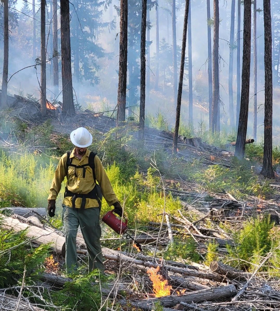
Fire danger remains high. New fire starts from lightning strikes are possible today.
Yesterday, crews continued to mop up, patrol and break apart hot debris piles along Vernon Park Road. On the Tiger Island Fire, firefighters sought out heat signatures identified on the infrared flight and mopped them up. On the Hwy. 113 and Elizabeth Fires, crews also looked for hot spots in the 10-Mile Creek drainage identified by the infrared flight and mopped those up where possible.
Overnight, all four fires received trace amounts of rainfall. Today, as weather allows, crews will seek out and mop up hot spots; patrol and hold containment lines; clean out needle cast; and create more depth inside the fires’ perimeters.
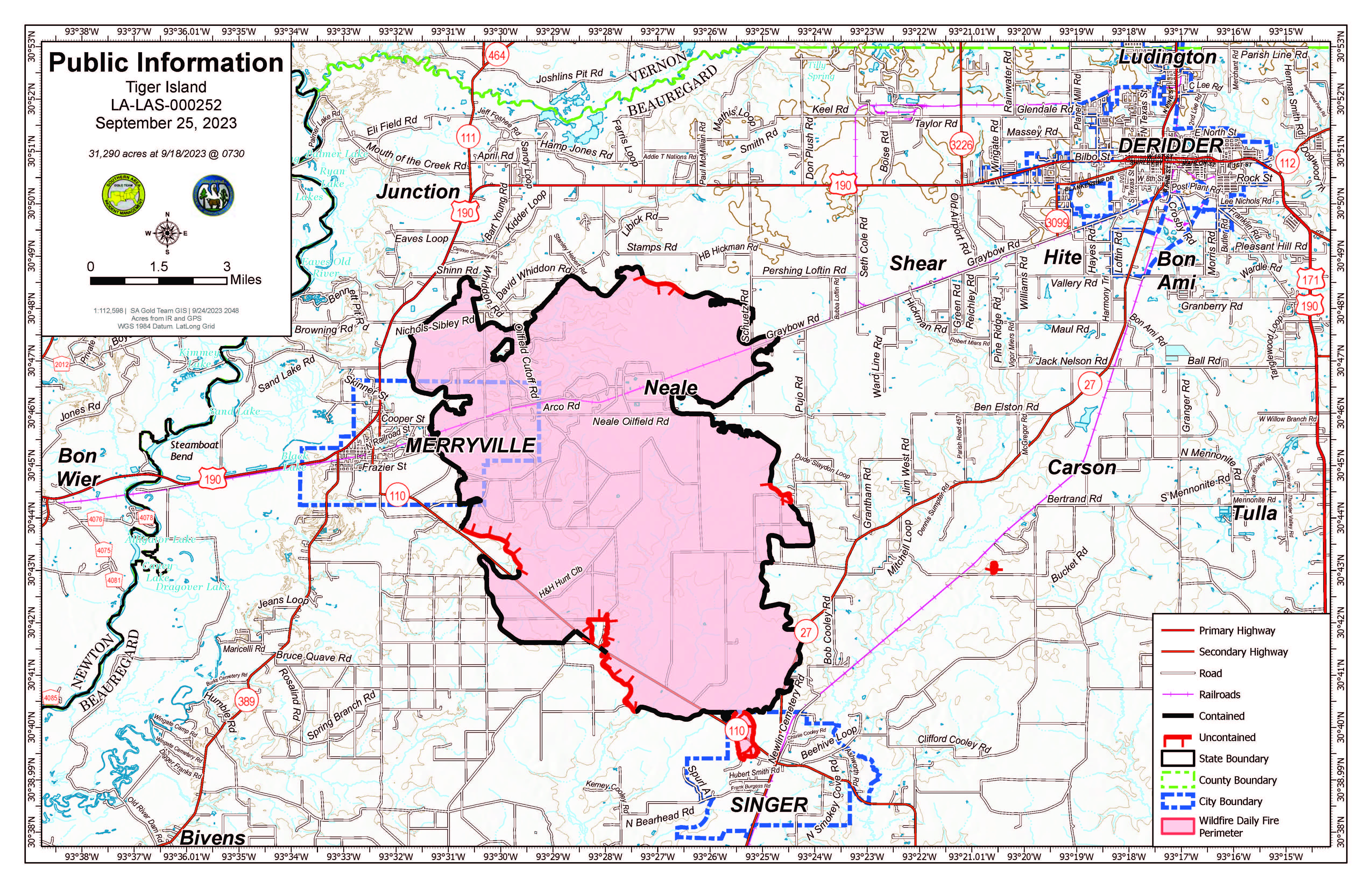
- Tiger Island Fire: 31,290 acres, no change | 84% contained| 224 personnel assigned InciWeb: https://inciweb.nwcg.gov/incident-information/lalas-tiger-island-fire
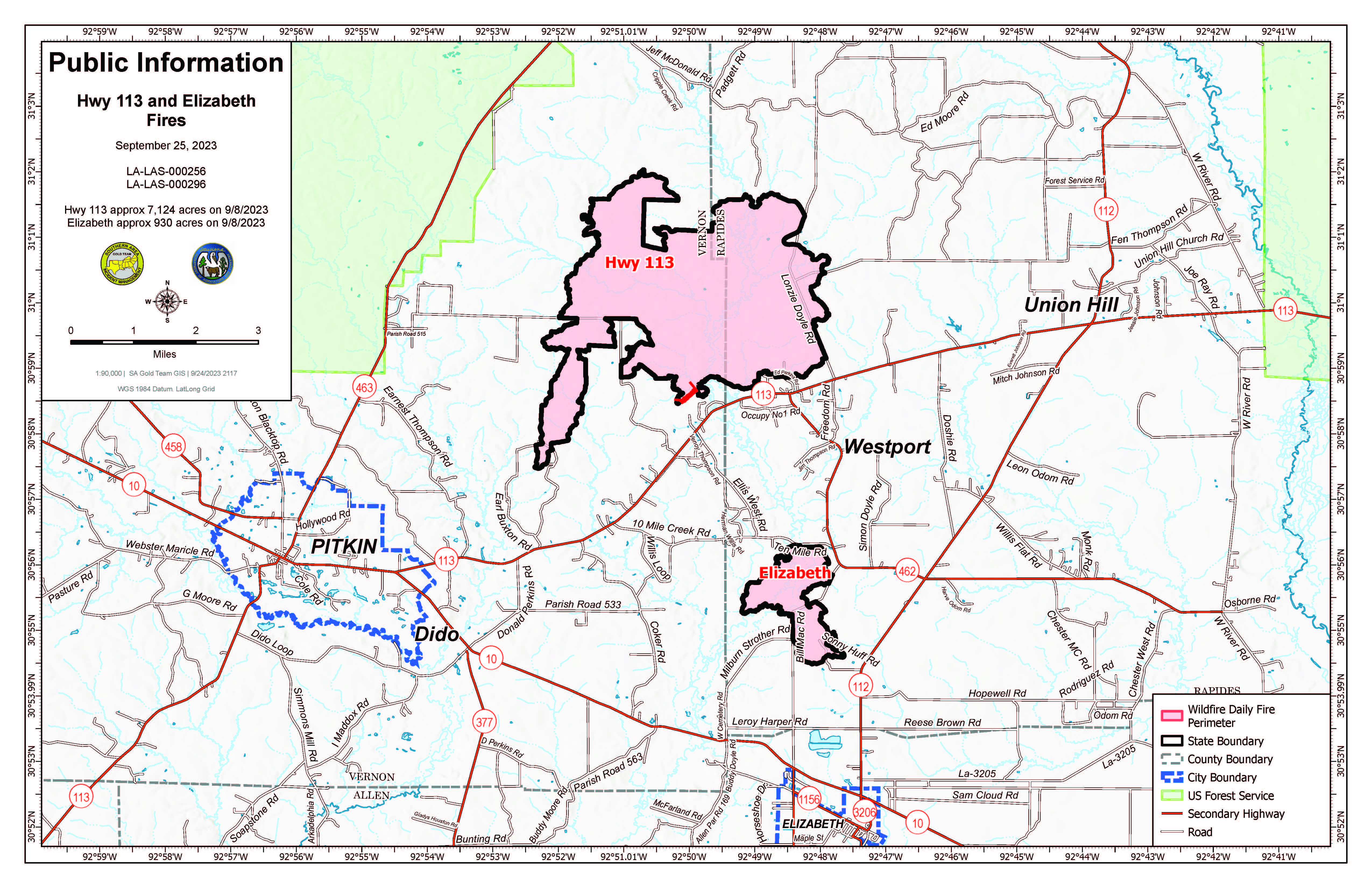
- Hwy. 113 Fire: 7,124 acres, no change | 95% contained | 35 personnel assigned InciWeb: https://inciweb.nwcg.gov/incident-information/lalas-hwy-113-fire
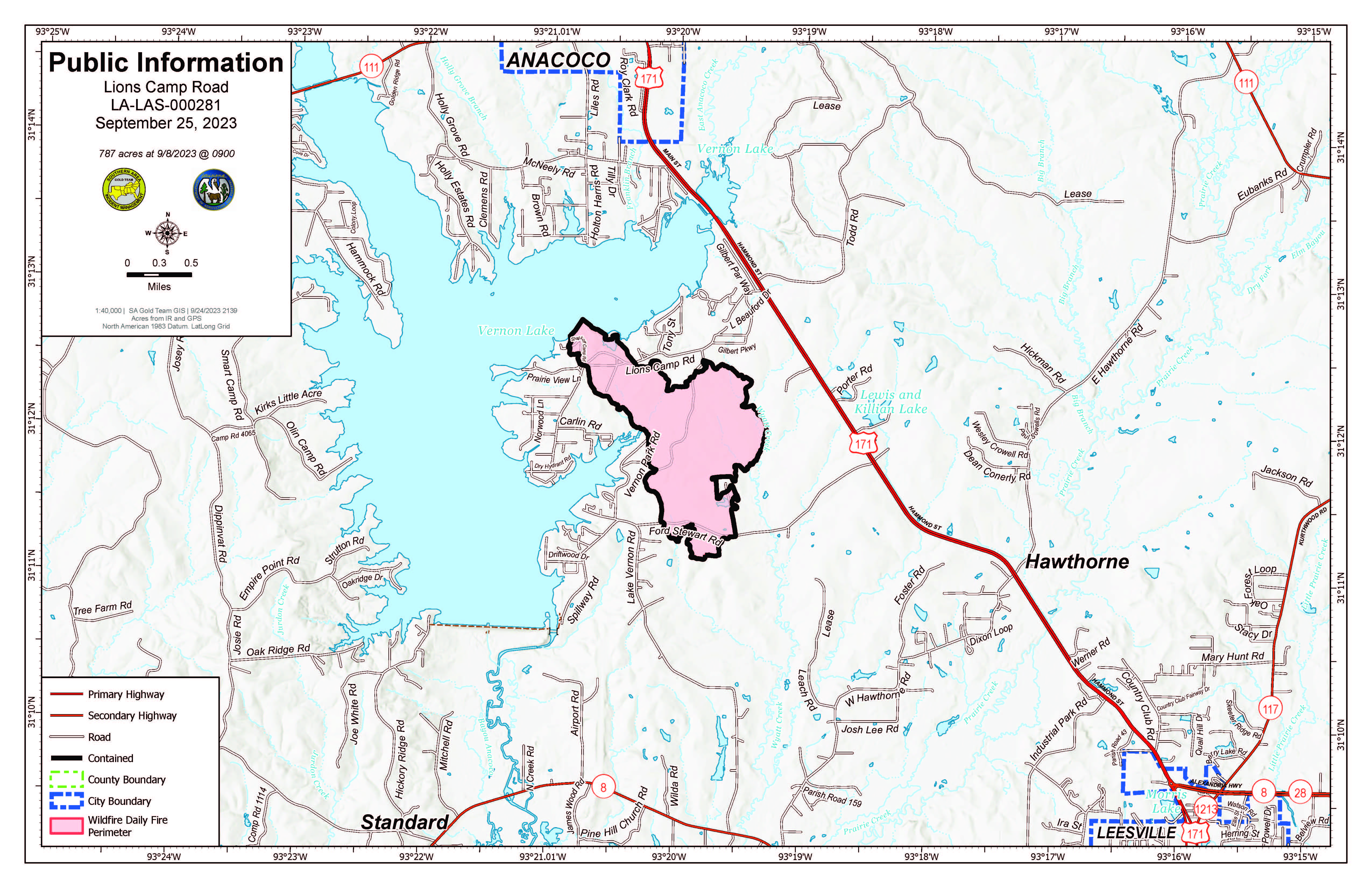
- Lions Camp Road Fire: 785 acres, no change | 100% contained | 1 person assigned InciWeb: https://inciweb.nwcg.gov/incident-information/lalas-lions-camp-road-fire
- Elizabeth Fire: 940 acres, no change | 100% contained | 21 personnel assigned InciWeb: https://inciweb.nwcg.gov/incident-information/lalas-elizabeth-fire
Equipment
Type 6 engines, dozers, tractor plow units, water tenders, medical squads and ambulances are assigned to the fires. Aerial resources including helicopters and fixed-wing aircraft also are available. Parish authorities and departments, sheriff’s offices, and the Governor’s Office of Homeland Security and Emergency Preparedness are providing additional support.
Weather and Fire Behavior
A front approaching from the northwest will bring the potential for afternoon pop-up showers and thunderstorms over the region. Some of the showers and storms may bring potential heavy rainfall, lightning and gusty winds with a marginal risk for flash flooding and strong to severe thunderstorms. Any rainfall will not be enough to erase the current drought conditions. The rainfall and cloud cover Monday will again keep temperatures slightly cooler and limit humidity from falling below 60%. Additional showers and storms are possible Tuesday through Thursday as the front is slow to push through the state and out over the Gulf of Mexico. Toward the end of the week, mostly sunny skies, lower humidity and afternoon wind gusts will likely bring back elevated fire weather.
Fire behavior is expected to decrease temporarily with increased humidity, cloud cover and lower temperatures. Minor smoldering is possible on the Tiger Island, Hwy. 113 and Elizabeth Fires. Lightning from thunderstorms brings an outside chance for new fire starts.
Air Quality
Smoke may occur in reburn areas. Air quality information is available at https://fire.airnow.gov.
Temporary Flight Restrictions (TFRs)
TFRs remain in place over the Tiger Island Fire (https://tfr.faa.gov/save_pages/detail_3_3911.html). A smaller, new TFR is in place for the Hwy. 113 and Elizabeth Fires https://tfr.faa.gov/save_pages/detail_3_4065.html). Remember: If you fly, we can’t.
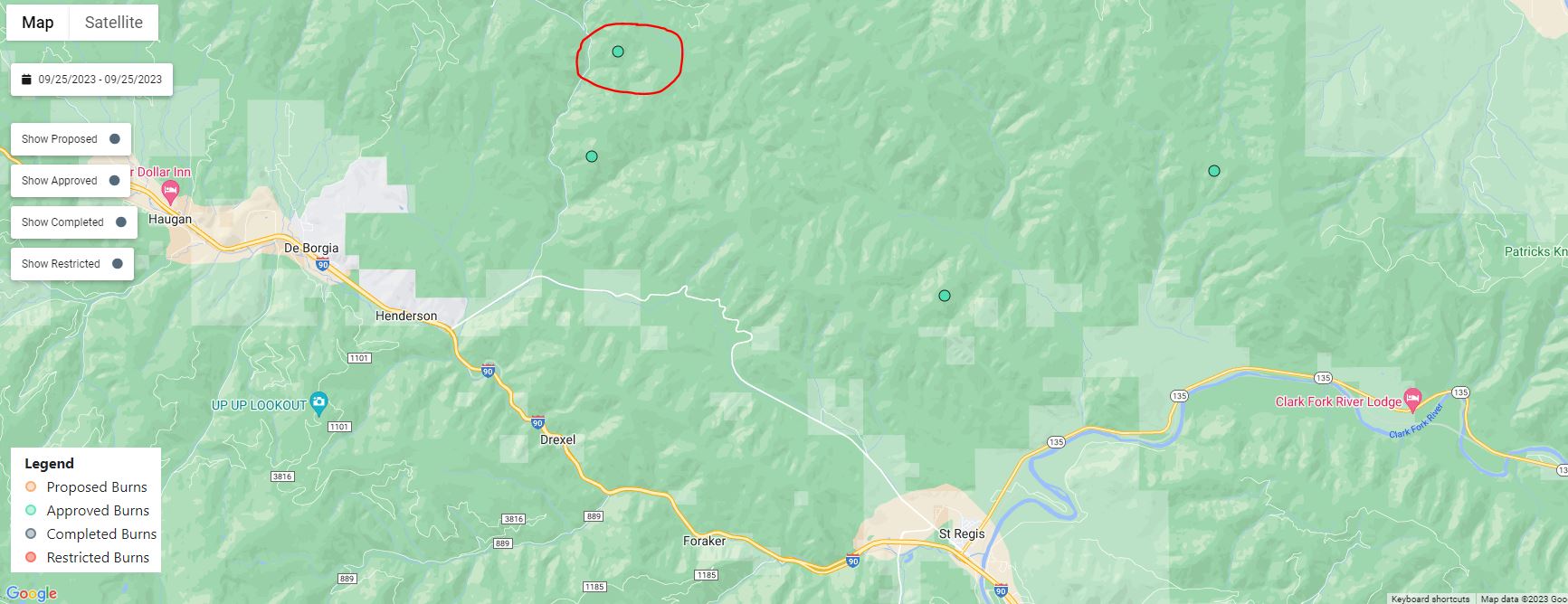
September 25 2023 Prescribed Fire Update
Related Incident: Lolo National Forest Prescribed Fire Operations
Publication Type: Announcement
Superior Ranger District:
Pending conditions, prescribed fire operations will take place on the Superior Ranger District to help reduce hazardous fuels and restore wildlife habitat.
The 13-acre prescribed fire burn is located approximately 4 miles northeast of the community of Henderson. Smoke may be visible from St. Regis or Cabin City for the duration of the burn. Firefighters and engines will implement the prescribed burn, patrol, and monitor the burning over the next few days.
All prescribed fires will be implemented in compliance with Montana air quality standards and coordinated with the Montana Department of Environmental Quality and the appropriate county health departments to reduce the impacts of smoke to neighbors, cooperators, and surrounding communities. Smoke may settle in valley bottoms and drainages overnight, but it is expected to dissipate within a few days.

Monday September 25 2023 Valentine fire update and map
Related Incident:
Publication Type: News
Size: 7,223 acres
Start Date: August 16, 2023
Cause: Lightning
Completion: 80%
Total personnel: 195
Location: 11 miles northeast of Young, Arizona and 27 miles
east of Payson, Arizona
Fuels: Ponderosa Pine, Hardwood litter and timber
Highlights: Yesterday, with the sunnier weather crews were able to continue to progress the fire’s edge to the south towards FSRD 411. Today crews will continue with hand and aerial operations adding depth to the interior of the fire.
Operations: Yesterday, warmer and dryer conditions allowed crews to continue hand and aerial ignitions, creating more depth towards the southern containment line. Scouting continued to the north side of Haigler Creek. Today, crews will work the southern edge of the fire along FSRD 411, conducting hand and aerial ignitions to add depth to the interior of the fire and keeping the line even with the road. Crews will be using heavy equipment to add depth to the containment line along FSRD 848.
Weather: Yesterday, conditions were dryer, sunnier, and warmer than previous days. Today is expected to be sunny and warm with a High in the high 70’s and slight winds out of the northeast.
Closures: An emergency closure order for the Valentine Fire has gone into effect as of 6 a.m. Sept. 5, 2023. The public is asked to avoid the fire area. The purpose of the closure order is to protect public health and safety during the Valentine Fire, and to protect assigned firefighting personnel engaging in wildland firefighting operations. Signs and gates will be in place to remind the public not to enter the fire area. Please visit the Alerts and Notices page for more information. https://www.fs.usda.gov/alerts/tonto/alerts-notices.
Safety: The health and safety of firefighters, and the public are always the highest priority. Members of the public are asked to avoid the fire area.
Smoke: The fire will produce considerable amounts of smoke due to excessive fuel accumulation. Smoke from the Valentine Fire may be visible in the surrounding areas for many days. Smoke-sensitive individuals and people with respiratory problems or heart disease are encouraged to take precautionary measures. An interactive smoke map available at, https://www.airnow.gov/wildfires/ allows you to zoom into your area to see the latest smoke conditions.
![]()
Information Links and Contacts:
Tonto National Forest https://www.fs.usda.gov/main/tonto/fire
InciWeb https://inciweb.nwcg.gov/incident-information/aztnf-valentine-fire Fire Email 2023.valentine@firenet.gov
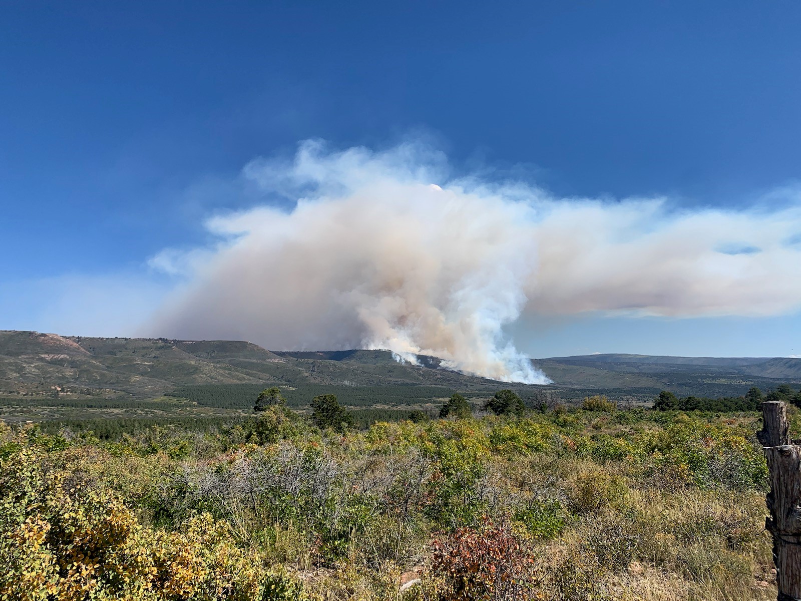
PM Update 09242023
Related Incident: Cow Creek Prescribed Burn
Publication Type: Announcement
Firefighters had a successful day on the #CowCreekRX. The conditions allowed them to treat 2500 acres. Operations will continue tomorrow if conditions are good. Smoke will continue to be visible.
Photo credit: GMUG NFs
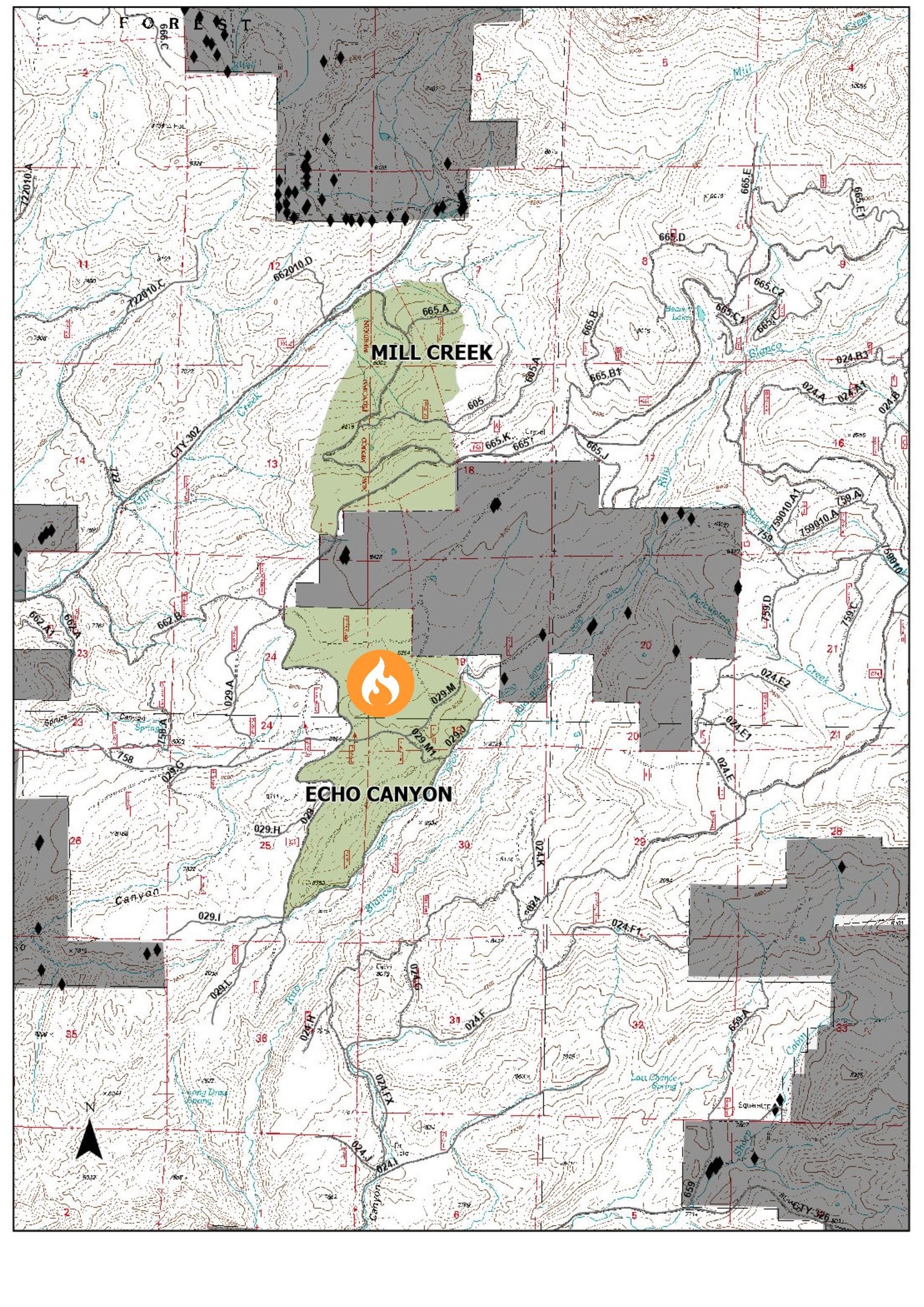
Pagosa Ranger DistrictEcho Canyon UnitPrescribed Fire 9242023
Related Incident: 2025 San Juan National Forest Prescribed Fire Program
Publication Type: News
**POSTPONED** Due to unfavorable weather and fuel conditions, the planned Pagosa Ranger District, Echo Canyon Unit, prescribed burn has been postponed until tomorrow September 25th.
Ignition Update 09242023
Related Incident: Cow Creek Prescribed Burn
Publication Type: Announcement
Due to ideal weather conditions, ignitions have begun on #CowCreekRX.
The Cow Creek prescribed burn project area is approximately 9 miles east of Gateway, Colorado and 25 miles southwest of Grand Junction, Colorado. The project area includes Cow Creek, Calamity Creek and Indian Creek.
The prescribed burn will be accomplished using joint-agency fire resources utilizing aerial and hand ignitions and will be closely monitored to ensure that they remain within the designated boundaries.
Smoke from the prescribed fire will be managed to have minimal impact on neighboring communities. Smoke may be visible in several communities, including Grand Junction, Whitewater, Gateway, Fruita, Delta, Montrose, and Norwood for multiple days. The public is advised not to call 911.
Prescription (RX) burning is important to maintain a fire adopted eco-system and is essential for wildfire prevention.
2023 SRF Lightning Complex Update September 24 2023
Related Incident: 2023 SRF Lightning Complex and Redwood Lightning Complex
Publication Type: News
Fire Update
2023 SRF Lightning Complex
Sunday, September 24, 2023 – 9:00 a.m.
Eastern Area Gold Team
Brian Jenkins, Incident Commander
Information Phone: 530-536-0767
Email: 2023.lightningcomplex@firenet.gov
Information Staffing Hours: 8 am to 8 pm
This update covers 5 of the 14 fires being managed as part of the SRF Lightning Complex. The Copper Fire (2184 acres) was absorbed by the Blue Creek #2 Fire. On September 22, 2023, the Bluff #1 Fire (4270 acres) and Blue Creek #2 Fire (9751 acres) were absorbed by the Mosquito Fire. The combination of Blue Creek #2 Fire, Bluff #1 Fire, and Mosquito Fire is now referred to as the Mosquito Fire. The remaining 6 fires (Big Foot, Blue Creek, Creek, Flat, Iron, and Merrill) totaling 34 acres, are contained and in patrol status. They are checked daily, and their size and containment are unlikely to change.
Current Situation: The 14 fires on this incident total 42,517 acres and overall containment is 8%. In total, 879 personnel are assigned to the incident. Following the very successful firing operations of the last several operational periods, today marks the start of a weather change. Wind direction may shift, and wind speed is forecasted to increase with the frontal system coming into the area. This may increase fire activity today in advance of the expected precipitation tomorrow. Firefighting operations will adjust to the gusty wind and future rain, focusing on holding the containment lines, extinguishing areas of heat along the lines, and watching for any wind-driven spotting from the fire into unburned areas.
For decades, “full suppression” has portrayed a message to contain fire whenever and wherever it happens to exist on the landscape. Though indirect strategies have been routinely implemented through the years, there has not necessarily been an emphasis toward reducing future wildland fire risk on individual wildland fires. Leveraging pre-identified control features within a suppression strategy can both suppress a wildland fire and reduce future risk to our communities and landscapes. We refer to those pre-identified control features as Potential Operational Delineation; otherwise, known as PODs.
Pearch Fire (11,131 acres, 6% contained) – The Structure Protection Group continues point protection of structures in the Butler Flats community and on the Salmon River Road, using hose and pumps, testing sprinklers, and maintaining readiness. An Evacuation Warning is in place for those residents in the Butler Creek area (SIS-1704) which means persons in the area need to be prepared to evacuate if conditions warrant. Firefighters are using hand lines around structures if needed to stop fire progress and removing fuel available to burn. Along the south side of the Pearch Fire near Orleans, crews are holding and improving line. Additional engines are being allocated to the area around the confluence of the Salmon and Klamath Rivers to ensure the safety of the community as the wind speeds increase today. Firefighters are monitoring the fire as it backs downslope from ridgetops.
The northwest flank of the Pearch Fire continues to send material rolling downslope onto the Highway 96 corridor and crews are working with CalTrans to improve travel safety. Please reduce your speed if you are traveling through the fire area, watch your surroundings, and be prepared for smoky conditions and falling rocks and debris. The Unmanned Aerial Systems (UAS) successfully completed some firing operations, preventing the fire from making an uphill run by using low intensity fire to consume available fuels. An additional UAS collected infrared (IR) data on the fire, providing mapping information of fire activity and areas of heat.
Mosquito Fire (29,266 acres, 6% contained) – The mastication and chipping work continue, and crews are making progress along both the Slate Creek and Bluff Creek Roads. Crews will continue to patrol containment lines along the eastern side and along portions of the Go Road and along the Onion Creek Road, looking for areas of heat, and making sure fire does not move into unburned areas outside the fire area. A contingency of engines remains on both fires throughout the nighttime hours.
Marlow Fire (1,987 acres, 0% contained) – There was minimal activity on the Marlow Fire yesterday. This fire is in a remote area and is bounded by indirect control lines to the east and south and prior fire footprints where fuels are lighter. No values are threatened by the Marlow Fire. A Wildland Fire Module continues to monitor and assess conditions on the ground and air resources will monitor from above. Fire managers from the 2023 SRF Lightning Complex continue to coordinate with managers on the Happy Camp Complex due to the proximity of the Elliot Fire.
Monument (2 acres, 0% contained) and Let er-Buck (96 acres, 0% contained) Fires – A confinement strategy is being used to address these two fires due to limited values at risk and the remote, steep terrain with associated safety concerns for the firefighters. Terrain, natural fire barriers such as rock outcroppings, and old fire footprints where fuels are limited will be used to confine fire growth until season ending precipitation extinguishes the fires. These fires are checked regularly by aerial patrols to ensure they remain within acceptable bounds.
Weather: Cloud cover will increase today with the incoming frontal system and this is expected to impact the fire area for the next couple days. Humidity levels will rise in higher elevations, but the cloud cover can trap warm air in valleys, limiting overnight humidity recovery in the lower elevations. Today’s temperatures will range from 53-73 with wind speeds increasing from 10-15 in the morning to 25 mph in the afternoon with gusts up to 30 mph on exposed ridges. The front is forecasted to bring light rain today with potential for precipitation increasing overnight and into Monday.
Evacuation Information
Siskiyou County Office of Emergency Services: https://www.co.siskiyou.ca.us/emergencyservices
Closures
Six Rivers National Forest: Area and campground closures are in effect on portions of Six Rivers National Forest. They can be found at: https://www.fs.usda.gov/detail/srnf/notices/?cid=FSEPRD1096395.
Additional Fire Information
Facebook: https://www.facebook.com/2023SRFRedwoodLightning
More Fire Information Links: www.linktr.ee/srffirepio
For Air Quality Information: www.airnow.gov
NOTE: For information about the Elliot or Hancock Fires which are part of the
Happy Camp Complex, please visit https://linktr.ee/happycampcomplex2023 .
Informacin al da para los incendios 24 de septiembre
Related Incident: Anvil FireFlat Fire
Publication Type: News
Incendio Anvil
Área: 21,293 acres | Fecha de Inicio: 25 de agosto, 2023 | Localizado: 8 millas Este de Port Orford, OR
Contención: 16% | Personal: 1,362 | Recursos: 38 escuadrillas de bomberos, 8 helicópteros, 50 camiones de bomberos
Debido a la influencia favorable del tiempo, las escuadrillas de bomberos reforzaron las líneas de contención, obteniendo como resultado un incremento en el porcentaje de contención del incendio, aun con el crecimiento adicional ocurrido en los últimos días. Se completo la operación estratégica de quema en el eje Norte del perímetro del fuego con la finalidad de remover la vegetación y crear espacios críticos defendibles cercanos a las residencias en el caso de que los vientos de 55 mph originados desde el Sur arribaran en el área del incendio antes de las lluvias pronosticadas. La maquinaria pesada, incluyendo buldóceres y masticadores de la Asociación de Protección del Bosque de Coos (CFPA), lograron finalizar y extender las líneas de contingencia al Sur del corredor de Sixes River. El día de ayer, la porción mas activa del incendio se observo en la esquina Noreste, en donde las llamas cruzaron la bifurcación Sur de Sixes River. Las escuadrillas de bomberos acertaron al acorralar fuegos de menor tamaño que se iniciaron por las brasas en las afueras de las líneas de contención y cerca del área de Sunshine Bar. Fueron apoyados considerablemente por los helicópteros que derramaron acerca de 155,000 galones de agua y con los bomberos con maquinaria pesada, pudiendo limitar la propagación del fuego. Los bomberos continúan patrullando la línea de incendio a lo largo del corredor de Elk River, enfocándose en la zona en donde el material incendiado podría rodar hacia la parte inferior de las pendientes pronunciadas y potencialmente cruzar las líneas de contención. Los meteorólogos en el incidente aun no aseguran si la intensidad del viento o la presencia de lluvias pesadas alcanzaran primeramente al incendio Anvil. Estos expertos en el clima darán información actualizada al personal del incendio a lo largo del día, y de esta manera, los bomberos podrán enfrentar el incendio y navegar sobre el sistema de caminos que serán impactados por precipitación significativa.
Evacuaciones: La Oficina del Alguacil para el Condado de curry, ha identificado cuatro zonas de evacuación alrededor del incendio Anvil. Puede encontrar información en un mapa interactivo: https://bit.ly/45UIh2E. Zonas 1 y 4 se encuentran en un Nivel de Evacuación 3 “SALGA”. Zonas 2 y 3 en un Nivel de Evacuacion 2 “PREPARESE” “Get Set“. Puede registrarse en el sistema de Alertas de emergencias para el condado: https://bit.ly/CurryCoEM
Ordenes de Cierres para ciertas áreas y carreteras: Para la seguridad de los bomberos y para el público en general, el Bosque Nacional de Rogue River-Siskiyou y la Agencia para el Manejo de Tierras en el distrito de Coos Bay, han dictado una orden de cierre para el Incendio Anvil. Puede encontrar mapas e información más detallada en: https://inciweb.wildfire.gov/incident-closures/orrsf-anvil-fire.
Incendio Flat
Área: 34,242 acres | Inicio: 15 de julio, 2023 | Localizado: 2 millas Sureste de Agness, OR
Contención: 75% | Personal: 11 | Recursos: 3 camiones de bomberos
Permanece en efecto la Orden de Cierre para el Bosque nacional de Rogue River-Siskiyou. Informacion: https://inciweb.wildfire.gov/incident-closures/xx1002-flat-fire
Informacion General
Condiciones climáticas: El experto en meteorología que fue asignado al incendio, estará proveyendo de una manera frecuente, datos actualizados a través del día de hoy tan pronto como el sistema del tiempo se introduzca en el área. Los pronósticos actuales incluyen ráfagas de vientos del Sur alcanzando hasta los 55 mph sobre las cumbres. El flujo en alta mar podría empezar a producir lluvias mínimas en horas tempranas de la mañana. Se ha pronosticado la mayor parte de la cantidad de lluvia en horas de la tarde del día de hoy. Se proyecta una acumulación de lluvia desde el día de hoy hasta el martes en un rango de 2 a 4 pulgadas, trayendo como resultado un potencial de peligro en el flujo de escombros en el área del incendio. La Agencia Nacional de Meteorología ha emitido un Aviso de Inundación el cual entre en efecto desde las 11:00pm del día de hoy hasta las 8:00pm en horas de la tarde del lunes. Flujos de escombros se hacen posibles en áreas que han sido quemadas recientemente.
Condiciones del humo: Para información al día en la presencia del humo y la calidad del aire, visite: https://bit.ly/SWORsmoke. La presencia del humo y la capa de nubes marina están mezclándose y estableciéndose en las elevaciones bajas durante la noche, causando una baja visibilidad en las carreteras. Por favor conduzca despacio y con las luces encendidas al conducir su vehículo en cualquier área de incendio.
Caltrans ha publicado un horario del cierre de carreteras y restricciones en las líneas de tráfico, para el Hwy. US 199. Las autoridades locales recomiendan no utilizar esta ruta si no es realmente necesario. Para encontrar información específica en el acceso de carreteras, por favor lea el sitio de Caltrans QuickMap en: https://quickmap.dot.ca.gov/ y también el sitio de Oregon Department of Transportation site en: https://www.tripcheck.com/. No utilize las carreteras forestales como una ruta alternativa.