
Settings - change map background and toggle additional layers
Filter - control incident types displayed on map.
Zoom to your location
Reset map zoom and position
Could not determine your location.
Show Legend
 Wildfire
 Prescribed Fire
 Burned Area
Response
Burned Area
Response Other
Other
Ida
Unit Information
Incident Contacts
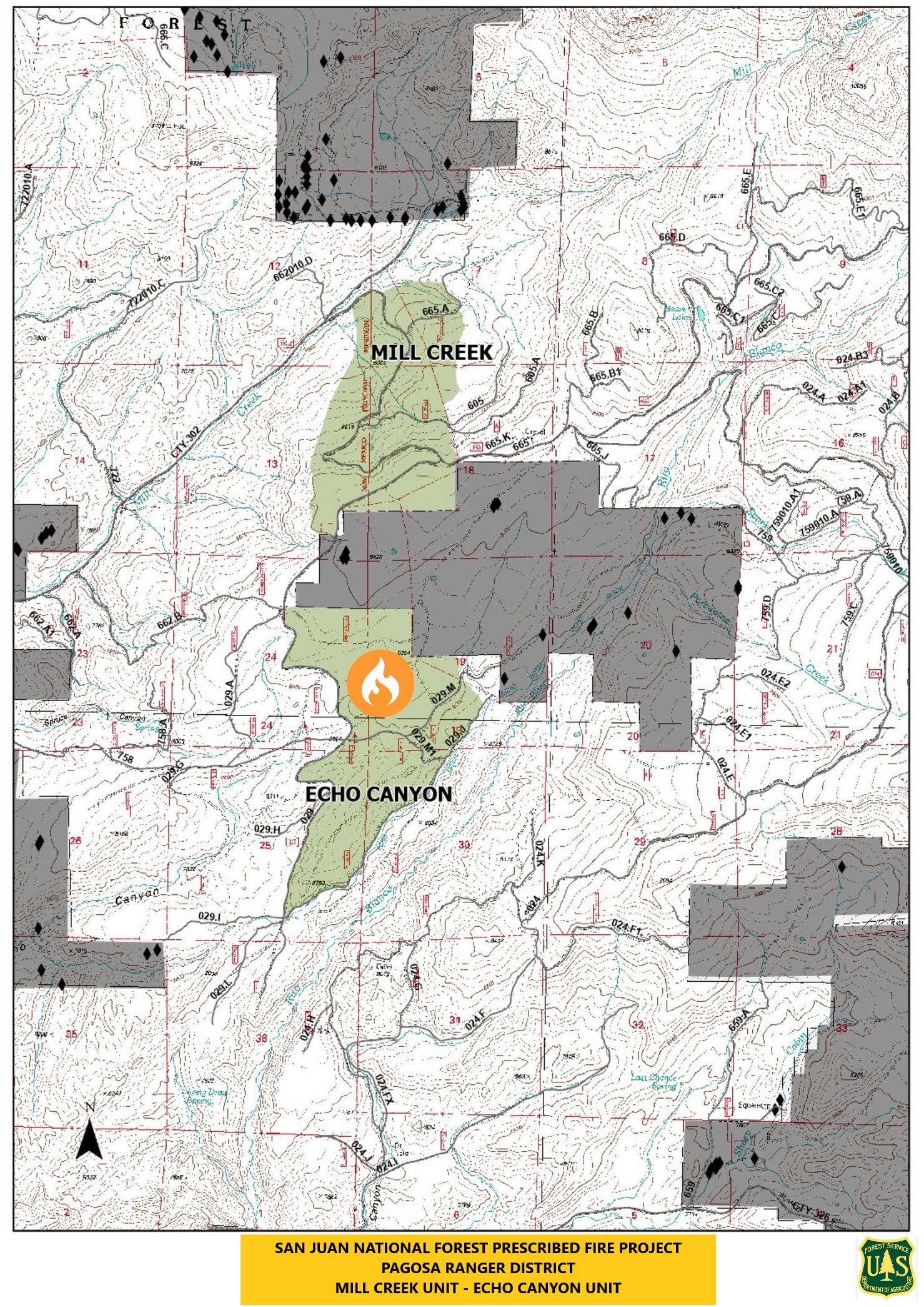
San Juan National Forest Prescribed Fire ProjectPagosa DistrictEcho Canyon Unit9232023
Related Incident: 2025 San Juan National Forest Prescribed Fire Program
Publication Type: News
The USDA Forest Service - San Juan National Forest, Pagosa Ranger District, is planning to conduct several prescribed burns in the Echo Canyon Unit starting tomorrow, September 24th. Burning operations will take place over multiple days when weather and fuel conditions are favorable for ignition.
Tomorrows planned prescription burn is set to start at 10am. The 550-acre prescribed burning operation will take place on the north end of the Echo Canyon Unit, located west of Rito Blanco Ranch. If you are in the area, please exercise caution as firefighters and firefighting apparatuses will be actively working and patrolling the area. Some smoke may be visible.
2023 SRF Lightning Complex Update September 23 2023
Related Incident: 2023 SRF Lightning Complex and Redwood Lightning Complex
Publication Type: News
Fire Update
2023 SRF Lightning Complex
Saturday, September 23, 2023 – 9:00 a.m.
Eastern Area Gold Team
Brian Jenkins, Incident Commander
Information Phone: 530-536-0767
Email: 2023.lightningcomplex@firenet.gov
Information Staffing Hours: 8 am to 8 pm
This update covers 5 of the 14 fires being managed as part of the SRF Lightning Complex. The Copper Fire (2184 acres) was absorbed by the Blue Creek #2 Fire. On September 22, 2023 the Bluff #1 Fire (4270 acres) and Blue Creek #2 Fire (9751 acres) were absorbed by the Mosquito Fire. The remaining 6 fires (Big Foot, Blue Creek, Creek, Flat, Iron, and Merrill) totaling 34 acres, are contained and in patrol status. They are checked daily, and their size and containment are unlikely to change.
Current Situation: The 14 fires on this incident total 40,670 acres and overall containment is 7%. In total, 1,039 personnel are assigned to the incident. Yesterday’s strategic firing operations were very successful. Ground crews have spent several operational shifts working in conjunction with aerial assets to accomplish objectives. Substantial progress was made in strategic firing operations on the top of several ridges in the interior area between the Mosquito and Bluff #1 Fires. These ridges are within the established control lines that have been improved and secured with recent firing operations from ground crews. Using low intensity fire, under these ideal conditions, moves us towards restoring and protecting resources vital to the culture and well-being of the tribes and communities of the Klamath River Basin. Additionally, the Unmanned Aerial Systems (UAS) firing operations provided a valuable tool needed to accomplish the incident objectives. The UAS, along with helicopters with ignition capacity, were able to reintroduce fire in areas too steep and remote for ground crews to safely achieve objectives.
The weather yesterday allowed for not only strategic firing conditions, but also favorable flying conditions for the aerial assets. The result was a low intensity burn, slowly backing downhill off the ridges, through yesterday evening, reducing the amount and density of fuels available to burn and reducing the likelihood of high intensity fire in the area in the future. The interior strategic firing operations that were accomplished are important culturally and scientifically and represent a shift in the approach to fire suppression when safety priorities and conditions allow.
The combination of Blue Creek #2 Fire’s movement to the south and the successful strategic firing operations between the Bluff #1 and Mosquito Fires has resulted in all these fires being combined into what will now be referred to as the Mosquito Fire.
Pearch Fire (10,659 acres, 7% contained) – Yesterday, the Structure Protection Crews were joined by additional crews to hold and improve the containment line around the southwest flank of the Pearch Fire. Firefighters were inserted into the southern area of the fire to assess fire growth and provide additional information for the structure protection plans. Fire managers took advantage of the weather conditions and continued to conduct the strategic firing operations north of Butler Flats, south of Somes Bar. Smoke from these operations was visible yesterday north of Orleans. The Pearch Fire has reached Highway 96 on the northwest flank and the fire is sending material rolling downslope onto the road. Crews are working with CalTrans to keep travel on the highway safe. Please observe posted reduced speed limits and watch your surroundings if you are traveling through the fire area as rocks and debris may be falling into the road. Today crews are holding and maintaining yesterday’s successful operations, working point protection around the Butler Flats community, and monitoring the fire along the highway. Structure Protection crews are working with pumps, hose systems, and sprinklers where needed to protect structures. An Evacuation Warning is in place for those residents in the Butler Creek area (SIS-1704) which means persons in the area need to be prepared to evacuate if conditions warrant.
Mosquito Fire (27,892 acres, 17% contained) – Crews are holding and improving containment line along the eastern side and along portions of the Go Road, to secure the road as a control line. There was minimal fire activity on the Bluff #1 Fire and south flank of Mosquito Fire yesterday and crews focused on checking the fire’s edge along the Onion Creek Road. Crews continued to use firing operations to secure the remaining control lines to close off the potential for the wildfire to move east of the Go Road. Firefighters are mopping up, holding and improving the line, taking advantage of the wind direction yesterday to increase containment depth along Bluff Creek Road. As firing operations on the exterior control lines came together, aerial platforms shifted and started strategic firing operations on the top of several ridges within the fire perimeter above Bluff Creek. The use of aerial ignition devices allows firefighters to meet incident objectives while providing for firefighter safety. Firefighters continue to monitor the fire behavior and effects. The Mastication work continued to make important progress south along the Bluff Creek and Slate Creek Roads. A contingency of engines remains on both fires throughout the nighttime hours.
Marlow Fire (1,987 acres, 0% contained) – This fire and the northern part of the Mosquito Fire are bounded by indirect control lines to the east and south and prior fire footprints where fuels are lighter. Yesterday, the Marlow Fire had some small growth but remained relatively quiet. These fires are in a remote area and burning within prior fire footprints and no values are currently threatened. The Marlow and Mosquito Fires are anticipated to burn together within the next few days. A Wildland Fire Module continues to monitor and assess conditions on the ground and air resources will monitor from above. Fire managers from the 2023 SRF Lightning Complex continue to coordinate with fire managers on the Happy Camp Complex due to the proximity of the Elliot Fire.
Monument (2 acres, 0% contained) and Let er-Buck (96 acres, 0% contained) Fires – A confinement strategy is being used to address these two fires due to limited values at risk and the remote, steep terrain with associated safety concerns for the firefighters. Terrain, natural fire barriers such as rock outcroppings, and old fire footprints where fuels are limited will be used to confine fire growth until season ending precipitation extinguishes the fires. These fires are checked regularly by aerial patrols to ensure they remain within acceptable bounds.
Weather: Today will conclude the warm and drying trend, with precipitation forecasted to start moving into the area tomorrow. Temperatures today will range from 56-70, with winds from 5-9 mph. A high cloud layer will move over the fire area in the afternoon, bringing with it slightly cooler temperatures and breezy conditions on exposed ridgelines. Cloud cover will increase overnight with a chance of light rain.
Evacuation Information
Siskiyou County Office of Emergency Services: https://www.co.siskiyou.ca.us/emergencyservices
Closures
Six Rivers National Forest: Area and campground closures are in effect on portions of Six Rivers National Forest. They can be found at: https://www.fs.usda.gov/detail/srnf/notices/?cid=FSEPRD1096395.
Additional Fire Information
Facebook: https://www.facebook.com/2023SRFRedwoodLightning
More Fire Information Links: www.linktr.ee/srffirepio
For Air Quality Information: www.airnow.gov
NOTE: For information about the Elliot or Hancock Fires which are part of the
Happy Camp Complex, please visit https://linktr.ee/happycampcomplex2023 .
Happy Camp Complex Daily Update September 23 2023
Related Incident: 2023 Happy Camp Complex Klamath NF
Publication Type: News
Happy Camp Complex Daily Update September 23, 2023
WEATHER: The winds from the southwest will continue today: expect smokey conditions along the Highway 96 corridor. Most of this smoke is from the Six Rivers Complex fires not the UFish and Elliots fires. The rain coming in Sunday night through Monday will temporarily mitigate the smoke. Please be advised the National Weather Service has issued a Flood Watch for Siskiyou County beginning Sunday afternoon through Monday evening; camping near the local creeks and rivers is not advised over this time. Hunters, be aware!
FIRE BEHAVIOR: Although the fire hasn’t moved beyond the containment lines in several days, there is still active fire burning within both fire footprints. The southwest winds could move the fire, particularly in the areas of open line on both fires, both which have a southwest orientation. Specifically, this is the open line along Titus Creek of the UFish Fire and on the Elliot Fire the open line running from Dry Lake Rd to Swillup Creek and along the northeast side of Pony Peak
UFISH FIRE: 7,650 acres at 70% containment.
ELLIOT FIRE: 13,376 acres at 70% containment.
The hazard tree mitigation along Forest System roads 17N11, 17N12 and 17N32 is a major part of the work of this fire and will continue for the next few days. The other focus is on suppression repair in both fire footprints. Crews are water-barring dozer lines and handlines, spreading wood chips and pulling brush in over areas that are secure to protect the soil. Mop up continues along Highway 96 on both fires. Interior fuel islands continue to burn and produce the only smoke from these fires. There is no active burning showing up on infra-red drone monitoring, although there are small spots of heat along Titus and Swillup creek drainages.
SMOKE EFFECTS: Smoke is expected to remain in the Very Unhealthy to Hazardous range for much of the day along Highway 96 and at Happy Camp. Southwest winds will bring smoke over our area late this afternoon and into the evening. Sunday is expected to show more clearing out of the smoke and there is a strong chance rain Sunday night into Monday that will wash out some of the smoke. For more details on smoke movement, go to Wildfire Smoke Outlook
EVACUATIONS: View current Siskiyou County evacuation orders and warnings by visiting https://community.zonehaven.com. Siskiyou County residents, make sure you are signed up for the CodeRED emergency alert system at: https://bit.ly/SiskiyouCodeRedEmergencyAlert.
CLOSURES: A closure order has been implemented in the Klamath National Forest. Find more information at https://bit.ly/KlamathNFAlertsNotices.
As hunting season continues, please be aware of area closures within our national forests. Contact local Forest Service offices for specific information.
DELAYS: One-way traffic control is on Highway 96 at various locations, from 5 miles east of Seiad to the Klamath River. https://roads.dot.ca.gov/
Morgan Fire Daily Update September 23 2023
Related Incident: Morgan Fire
Publication Type: News
Morgan Fire Update: Saturday, September 23, 2023
Fire Information line: 541-460-7602 8am-8pm
The Morgan Fire is burning in steep, forested terrain, approximately 21 miles northwest of Lakeview, Oregon and 8 miles north of Quartz Mountain, on both private and National Forest System lands. The fire was reported at 2:44 pm on September 18. Cause is under investigation.
Temporary Road Closure: On Thursday, the Fremont-Winema National Forest issued a temporary closure for public safety on a segment of Forest Service Road 2800, between its junction with Forest Road 3428 on the north and Forest Road 2800-016 on the south. A copy of the order and map is on the Forest website: https://www.fs.usda.gov/fremont-winema
Yesterday: Firefighters made good progress building hand and dozer line around the entire fire perimeter. About a dozen spot fires outside the main perimeter on the southwest portion of the fire were detected and contained with dozer and hand line. Crews have installed hose lines on the west side and reinforced the fire line by mopping up inside the perimeter and felling hazard trees. Crews around much of the eastern flank patrolled and monitored established line. On the southern flank, firefighters constructed fire line directly at the fire’s edge through the most inaccessible and difficult terrain.
Today’s Activities: Firefighters will strengthen fire line and deepen the mopping operations, employing extensive hose lays to deliver water to the fire’s edge. Operations are focused on strengthening containment lines ahead of windy weather predicted for Sunday.
Weather: Today will be sunny with increasing gusty winds and temperatures in the low 60s.
Evacuations: There is currently a Level 1 (“Get Ready”) Evacuation. Evacuation maps are posted on the Morgan Fire Inciweb page and the Lake County, OR website: https://www.lakecountyor.org/
Be wildfire aware! Avoid activities that can cause an accidental spark.
https://www.readyforwildfire.org/prevent-wildfire.
Fire Information and Links
Inciweb: https://inciweb.nwcg.gov/incident-information/orfwf-morgan-fire
Facebook:
https://www.facebook.com/nwteam7
https://www.facebook.com/SCOFMPFIREINFO
https://www.facebook.com/R6FWNF
Smith River Complex South Daily Update September 23 2023
Related Incident: Smith River Complex
Publication Type: News
CURRENT SITUATION: Friday’s calmer weather helped to minimize fire behavior. Crews continued to patrol containment lines of the main fire and US 199 while also mending any damage to the forest caused by firefighting operations. Crews monitored the fire on the east side, where it is burning in the Siskiyou Wilderness. Helicopters conducted water drops to reduce the fire’s intensity and slow its southward progression toward the Bear Basin Lookout.
There has been no significant activity on the Hurdy Gurdy. Crews continuously monitor the northwest portion as it smolders and creeps towards the main fire. Today resource’s will construct direct line using MIST (minimal impact suppression tactics) where appropriate and indirect line from 17N035 (H26) to Hurdy Gurdy Creek.
Predicted flood watch Sunday afternoon through Monday Evening is forecasted. Fire management officers are evaluating and planning to ensure the safety of firefighter crews and minimize damage to the forest. Some of the key safety measures are to remove heavy equipment from the burn area to pavement, this step helps prevent potential damage to the forest. They will also be deploying firefighting crews strategically in tactical locations allowing them to engage with the fire when conditions permit, enabling efficient firefighting efforts. Importantly, it also ensures that they can retreat to safety if conditions worsen or become hazardous. Safety is always a top priority.
WEATHER: ***FLOOD WATCH SUNDAY AFTERNOON THROUGH MONDAY EVENING***
A weak weather system will move in off of the Pacific today with clouds increasing and a chance of sprinkles this afternoon and evening. Valley temperatures 60-65°, Ridgetops 56-60°, Valley relative humidity 44-52%, Ridgetops 52-60%. Increased onshore flow with cloud cover will result in cooler temperatures and higher humidity. Ridgetop winds will be out of the west-southwest 4-7 mph in the morning increasing to 8-12 mph in the afternoon.
EVACUATIONS: Some Del Norte County evacuation zones remain under either a Level 2 (Get Set) or Level 1 (Get Ready) evacuation order. View the interactive evacuation map online: tinyurl.com/29vv2wpm.
AIR QUALITY: Smoke outlooks with air quality and forecast information are available here: tinyurl.com/258mfms3.
CLOSURES: US 199 in Del Norte County will be fully closed twice daily, Monday through Friday, from 8 AM to 11 AM and from 1 PM. to 4 PM. During all open hours, traffic will be one-way and piloted between Madrona and Oregon Mountain Road. Motorists should anticipate delays during all open hours. Caltrans provides information on current highway conditions online (roads.dot.ca.gov), by phone (800-427-7623), and on Facebook (facebook.com/CaltransD1).
Six Rivers National Forest reduced its forest closure order for the Gasquet, Lower Trinity, and Mad River Ranger Districts. The Forks’ Boat Launch, Myrtle Beach River Access and Margie’s River Access are open for public access. Visit updated closure order at fs.usda.gov/Internet/FSE_DOCUMENTS/fseprd1139169.pdf.
Daily Update Saturday September 23 2023 Tiger Island Hwy 113 Lions Camp Road and Elizabeth Fires
Related Incident: Tiger Island FireElizabeth FireLions Camp Road Fire
Publication Type: News
Tiger Island, Hwy 113, Lions Camp Road and Elizabeth Fires
Daily Update – Saturday September 23, 2023
Southern Area Complex Incident Management Gold Team
Louisiana Statewide Burn Ban
The Louisiana Office of the State Fire Marshal’s order prohibiting all private burning and the Louisiana Department of Agriculture and Forestry ban on all agricultural burning remain in effect. They are reevaluated weekly. Open burning with exposed flames and prescribed fires are prohibited. Visit https://sfm.dps.louisiana.gov/doc/press/pr_2023-36.pdf.
Fire Highlights
The Southern Area Gold Complex Incident Management Team assumed command of the fires today at 7 a.m. under the leadership of Incident Commander Patrick Pearson. The Gold Team would like to thank the Southern Area Blue Team for their leadership and work on the fires.
Needle cast continues to be a concern for firefighters on all four fires today, especially in the fires’ interior where hot spots remain due to heavier fuels. Crews will continue to mop up, patrol and hold containment lines, as well as blow needle cast from the fires’ perimeters. Firefighters will work further into containment lines to suppress hot spots and reburn, working toward a goal of a continual 200-inch mop-up standard. Air resources will drop water to cool reburn areas to help firefighters on the ground. Snag trees with weakened root systems remain a major safety concern.
Tiger Island Fire: 31,290 acres, no change | 84% containment| 121 personnel assigned
Hwy. 113 Fire: 7,124 acres, no change | 95% containment | 44 personnel assigned
Lions Camp Road Fire: 785 acres, no change | 100% containment | 7 personnel assigned
Elizabeth Fire: 940 acres, no change | 100% containment | 7 personnel assigned
Equipment
Type 6 engines, dozers, tractor plow units, water tenders are assigned to the fires. Available aerial resources include helicopters and fixed wing aircraft. Parish authorities and departments, sheriff’s offices, and the Governor’s Office of Homeland Security and Emergency Preparedness are providing additional support.
Weather and Fire Behavior
Patchy fog from yesterday’s showers will breakup by mid-morning. Today will be another hot and humid day as southerly winds continue to draw moisture from the Gulf of Mexico. This afternoon, some afternoon or evening showers and thunderstorms are possible. Southerly winds will increase on Sunday ahead of a cold front approaching from the northwest with lingering heat and humidity. Showers and thunderstorms are possible again Sunday night as the front approaches Louisiana.
Fire danger remains extremely high, especially for new starts. All indices that predict or measure fire conditions are at or near record levels. A new fire could ignite easily, organize rapidly and spread with high intensity. Weather combined with low fuel moisture continues to support the potential for moderate to high fire behavior.
Air Quality
Smoke may occur in reburn areas. Air quality information is available at https://fire.airnow.gov.
Temporary Flight Restrictions (TFRs)
TFRs are in place over the Tiger Island Fire (https://tfr.faa.gov/save_pages/detail_3_3287.html) and the Hwy. 113 and Elizabeth Fires (https://tfr.faa.gov/save_pages/detail_3_4500.html). If you fly, we can’t. Aircraft or drone intrusions endanger aircrews. Aircraft may be grounded for safety which puts ground crews at risk for increased fire activity.
Smith River Complex North Daily Update Saturday September 23 2023
Related Incident: Smith River Complex
Publication Type: News
Smith River Complex North, Daily Update, Saturday, September 23, 2023
Size: 94,508 acres (12,460 ac. in Oregon); Location: Grants Pass, OR; Cause: Lightning
Containment: 84%; Start date: August 15, 2023; Total personnel: 1,394
Resources: 31 crews 6 helicopters 37 engines 8 dozers 29 water tenders 6 masticators 1 Skid Steer
Yesterday: The operational focus shifted to fire suppression repair along with continued ground and aerial backhaul operations. Firefighters began preparing to manage for possible impacts from significant amounts of rain on the efforts to complete the secondary control line along the FS 1106 road.
Today’s Activities: Operational focus remains on fire suppression repair and equipment backhauling operations. Weather models suggest the possibility of significant rainfall on Sunday night, Monday and into Tuesday. Dry forest fuels may have less chance of ignition this weekend due to forecasted heavy rains. Possible debris flows and flooding with increased rain and winds may occur. One helicopter will remain assigned to the Smith River Complex North this weekend while others are reassigned to other parts of the fire area. Fire personnel assigned to the fire will be downsizing this weekend into early next week as suppression objectives are completed.
Evacuations: The Josephine County Sheriff has set the evacuation status to Level 1-BE READY. Levels will be reevaluated on a recurring basis. This includes the area west of US-199 in Josephine County, including the community of O’Brien and to the Oregon-California border. If you have internet access, you can monitor the Rogue Valley Emergency Management site. You can also sign up for evacuation alerts, updates and see an interactive Fire First Response Map with evacuation areas here: https://rvem.org/.
Smoke: Winds became offshore yesterday and will continue into next week. Most impacted communities will be the US-101 corridor from Port Orford to Gold Beach, and the Elk and Sixes River drainages. Some smoke as well may drift south to Brookings. Smoke levels can change rapidly depending on weather; check current conditions at: https://bit.ly/SWORsmoke
Area Closures: A closure is in place on the Rogue River-Siskiyou National Forest for Forest Road 1106 (South Elk Mountain Road), Forest Road 1205 (Lower Wheeler Road), and Forest Road 1983 (Mt. Emily Road) until October 31, 2023 or until rescinded. The closure allows for safe operations related to the Smith River Complex North. Closures on BLM land are in place as well. Visit bit.ly/RRSNFAlerts or https://www.blm.gov/orwafire for additional information.
Road Closures and Delays: Caltrans in Del Norte County issued a schedule of road closures and lane restrictions on US-199. Weekdays will have a combination of road closure and lane restrictions. Over the weekend, the road will remain open, but with lane restrictions and pilot cars. Expect delays. For specific information on road access, please see the Caltrans QuickMap site https://quickmap.dot.ca.gov/ and Oregon Department of Transportation’s https://www.tripcheck.com/. Local law enforcement cautions against any non-essential traffic along this route. Navigation apps and mapping programs have been routing travelers into active fire areas. Do not use forest roads as alternate routes.
Restrictions: Please respect the temporary flight restriction (TFR) established for the Smith River Complex. Keep drones away from firefighting operations and the TFR. If you fly, we can’t. Don’t be the reason a firefighting air mission has to divert! For more information on the TFR, visit https://tfr.faa.gov/.
South Fork Complex Update September 23 2023
Related Incident: South Fork Complex
Publication Type: News
South Fork Complex Update
Saturday, September 23, 2023
Fire Information: 208-510-7856, 8 a.m. to 8 p.m.
Email: 2023.southforkcomplex@firenet.gov
Linktree: https://linktr.ee/2023southforkcomplex
3-9 Fire: 2,840 acres with 85% containment
Pellitreau Fire: 3 acres with 100% containment
Pilot Fire: 1,055 acres with 100% containment
Sulphur Fire: 31 acres with 100% containment
3,929 acres and 90% overall containment for the South Fork Complex
A total of 170 personnel, crews, air support, engines, dozers, and water tenders support the incident.
3-9 Fire – Crews are actively engaged in repair activities falling snags and trees to reduce fuel loads by removing hazardous trees. Engines are monitoring the interior smoke and heat. Heavy equipment operators continue repairing roads and installing water bars while the United States Forest Service Resource Advisors (READs) follow behind addressing any potential concerns with tribal, cultural, and natural resources in the area. Excavators continue preparation work and begin transition to chipping operations.
The Pilot Fire is 100% contained. Crews continue to patrol the fire perimeter while actively engaged in suppression repair and are scouting out potential roads in need of rehab.
The Pellitreau Fire and the Sulfur Fire are 100% contained. Firefighters continue to patrol the fires periodically to ensure fire remains within containment lines.
Weather: A gradual cooling trend is expected Saturday. Afternoon highs will slightly drop to the lower to mid-60s, with humidity levels trending a little higher, 30-40%. Winds will be out of the west southwest with gusts to 12 miles per hour.
Forest Closure: Forest Closure orders for the South Fork Complex Fire continue to be in effect and are posted on the Shasta-Trinity National Forest and the Six Rivers National Forest websites. Please avoid closed areas.
Morning Update for Saturday September 23 2023
Related Incident: Bedrock FireLookout FirePetes Lake Fire2023 Horse Creek Fire
Publication Type: News
Saturday, September 23, 2023 - Morning Update
Current Status:
Lookout Fire: Size: 25,751 acres l Start Date: August 5 l Cause: Lightning l Containment: 50%
Bedrock Fire: Size: 31,590 acres l Start Date: July 22 l Cause: under investigation l Containment: 98%
Petes Lake Fire: Size: 3,254 acres l Start Date: August 25 l Cause: Lightning l Completion: 50%
Horse Creek Fire: Size: 763 acres l Start Date: August 24 l Cause: Lightning l Containment: 100%
Pothole Fire: Size: 109 acres l Start Date: August 25 l Cause: Lightning l Containment: 100%
Total Personnel: 763
Total Assigned Resources: 24 engines l 17 crews l 5 dozers l 21 water tenders l 3 masticators l 8 helicopters
Suppression: Over the past week, the Lookout Fire and Bedrock Fire have primarily displayed creeping and smoldering behavior, resulting in negligible fire growth. With minimal fire activity and precipitation moving into the region, the Lookout Fire is not predicted to grow much beyond its current footprint and efforts have shifted predominantly to patrol, monitor, and suppression repair. This strategy is based on the improved conditions, hard to access areas in the northern portions of the fire, and a reduced threat to people and property. Firefighters working on the Petes Lake Fire made progress towards completing chipping and mastication along the Crescent Lakes Highway and Forest Road 4628, near the Deschutes Bridge and Cascade Lakes Highway junction. The Horse Creek Fire and Pothole Fire continue to be patrolled, although there have been no signs of heat near the containment lines.
Suppression Repair: Repair work is ongoing across the Bedrock Fire and Lookout Fire. In areas where the fire burned hot and completely consumed vegetation, the soil's ability to absorb water is compromised, heightening the risk of mudslides and floods. Rainfall can lead to the erosion of loose soil, increasing sedimentation in water sources. Additionally, saturated soil weakens trees, making them susceptible to falling, posing risks to individuals. Post-fire repair efforts are imperative to mitigate these hazards and enhance the long-term health of fire-affected areas.
In the Bedrock Fire area, significant progress has been made with 13.2 miles of dozer line repair and 6.6 miles of handline rehabilitation completed. Crews have completed the clearing of ditches obstructed by slash and logs along Forest Road 1825. Repair efforts have primarily focused on mid-slope roads in the southern region and on higher-elevation, native surface, non-aggregate roads in the northern portions of the fire. Across the Lookout Fire, repair work is taking place within all divisions, including hauling logs and chipping in the northern portion of the fire. There are 28 miles of proposed dozer line repairs, of which 3.7 miles have been completed. Efforts are being directed towards completing dozer repair work on the north end In the Horse Creek Fire. Furthermore, Resource Advisors and hand crews are actively engaged in seeding and applying straw in disturbed areas along roads and dozer lines on the Bedrock Fire. This action aims to prevent erosion and inhibit the spread of invasive plants, utilizing a mixture of yarrow and native grasses for seeding.
Weather: Last night, the cloud cover interrupted the cooling trend with overnight lows in the upper 40s. Today will be the last dry day in the forecast as a cooling trend sets in with temperatures in the mid 50s to low 60s. Showers are possible overnight leading into consistently rainy days through much of next week.
Linn County Evacuations: Visit the Linn County Wildfire map for current evacuation information.
Lane County Evacuations: Visit the Lane County Lookout Fire Evacuation Areas map for current evacuation information.
Deschutes County Evacuations: Visit the Deschutes County Emergency Information map for current evacuations information.
Forest Closures: Emergency closure orders remain in place for the Willamette National Forest and the Deschutes National Forest. For information on Oregon hunting regulations and these forest closures, contact Oregon Department of Fish and Wildlife at (503) 947-6000.
Restrictions: Fire Restrictions are in place on the Willamette National Forest and Deschutes National Forest. Temporary Flight Restrictions remain in place over the Bedrock and Lookout Fire areas.
Smoke Outlook: A smoke outlook for West-Central Oregon includes the Lookout, Bedrock, Petes Lake, Horse Creek, and Pothole Fires. Another source for air quality information is the Fire and Smoke map from airnow.gov.
Fire Information:
Email: 2023.lookout@firenet.gov
Phone: 541-215-6735 (8 a.m. - 8 p.m.)
Facebook:
InciWeb: