
Anvil and Flat Fires Update September 23
Related Incident: Flat Fire
Publication Type: News
Anvil Fire
Size: 20,657 acres | Start Date: August 25, 2023 | Location: 8 miles east of Port Orford, OR | Containment: 9% | Total personnel: 1,321 | Resources: 37 crews, 8 helicopters, 47 engines
Fire managers and crews are preparing for the weekend’s forecast precipitation. More than 1,300 people are now assigned to the fire, allowing fire managers to deploy resources on the Anvil Fire’s multiple active fronts. Dozers and hand crews have been working continuously to construct line around pockets of fire south of Elk River between Sunshine Bar and Butler Bar campgrounds. The Coos Forest Protective Association and other crews successfully pushed back on the fire as it approached containment line above the North Fork of Dry Creek. Bucket drops once again made a big difference in supporting ground crews, drenching flames with more than 172,000 gallons of water.
Unmanned aerial systems (UAS) patrolled the Anvil Fire area overnight, greeting the day shift with real-time information about embers outside the main fire or trouble areas to prioritize. Today’s milder weather will provide firefighters an opportunity to shore up and extend containment lines that are likely to be tested later this weekend. There is a high probability for rain Sunday evening, but fire managers are preparing for potential high winds that may arrive prior to the much-needed moisture.
The Anvil Base Camp is near Cape Blanco State Park north of Port Orford off US Highway 101. Many of the crews and equipment assigned to the fire are operating out of this camp. Please drive slowly with your headlights on in this congested area.
Evacuations: Curry County Sheriff’s Office has identified four evacuation zones around the Anvil Fire. Zones 1 and 4 are in Level 3 “Go“ evacuation status. Zones 2 and 3 are in Level 2 “Get Set“ status. View the interactive evacuation map at https://bit.ly/45UIh2E. Sign up for Curry Co. emergency alerts at https://bit.ly/CurryCoEM.
Area and Road Closures: For the safety of firefighters and the public, the Rogue River-Siskiyou National Forest (RRSNF) and Coos Bay District Bureau of Land Management have issued closure orders for the Anvil Fire area. Find maps and closure information at https://inciweb.wildfire.gov/incident-closures/orrsf-anvil-fire.
Flat Fire
Size: 34,242 acres | Start Date: July 15, 2023 | Location: 2 miles southeast of Agness, OR | Containment: 75% | Total personnel: 11 | Resources: 3 engines
The RRSNF closure on the Flat Fire remains in effect, https://inciweb.wildfire.gov/incident-closures/xx1002-flat-fire.
General Information
Weather: There is a slight chance for light rain on Saturday. Light winds from the west and southwest will prevail, and patchy fog is expected. Heavy rain is a likelihood for Sunday evening to Monday morning, prompting a Flood Watch issuance by the National Weather Service. Winds will shift to the south with gusts of 35 to 55 mph. A meteorologist is working closely with fire managers to monitor the weather and share information to support planning to ensure the safety of firefighters in all weather conditions, both those that cause increases in fire activity and those that may trigger runoff or flooding.
Smoke: Visit https://bit.ly/SWORsmoke for current smoke and air quality updates. Smoke and the marine cloud layer are mingling and settling in the lower elevations overnight causing limited visibility along highways. Please drive slowly and with headlights on through any fire area.
Caltrans issued a schedule of road closures and lane restrictions on US-199 northeast from Crescent City. Local law enforcement cautions against any non-essential traffic along this route. For specific information on road access, please see the Caltrans QuickMap site, https://quickmap.dot.ca.gov/ and Oregon Department of Transportation site, https://www.tripcheck.com/. Do not use forest roads for alternate routes.
Anvil and Flat Fires Update September 23
Related Incident: Anvil Fire
Publication Type: News
Anvil Fire
Size: 20,657 acres | Start Date: August 25, 2023 | Location: 8 miles east of Port Orford, OR | Containment: 9% | Total personnel: 1,321 | Resources: 37 crews, 8 helicopters, 47 engines
Fire managers and crews are preparing for the weekend’s forecast precipitation. More than 1,300 people are now assigned to the fire, allowing fire managers to deploy resources on the Anvil Fire’s multiple active fronts. Dozers and hand crews have been working continuously to construct line around pockets of fire south of Elk River between Sunshine Bar and Butler Bar campgrounds. The Coos Forest Protective Association and other crews successfully pushed back on the fire as it approached containment line above the North Fork of Dry Creek. Bucket drops once again made a big difference in supporting ground crews, drenching flames with more than 172,000 gallons of water.
Unmanned aerial systems (UAS) patrolled the Anvil Fire area overnight, greeting the day shift with real-time information about embers outside the main fire or trouble areas to prioritize. Today’s milder weather will provide firefighters an opportunity to shore up and extend containment lines that are likely to be tested later this weekend. There is a high probability for rain Sunday evening, but fire managers are preparing for potential high winds that may arrive prior to the much-needed moisture.
The Anvil Base Camp is near Cape Blanco State Park north of Port Orford off US Highway 101. Many of the crews and equipment assigned to the fire are operating out of this camp. Please drive slowly with your headlights on in this congested area.
Evacuations: Curry County Sheriff’s Office has identified four evacuation zones around the Anvil Fire. Zones 1 and 4 are in Level 3 “Go“ evacuation status. Zones 2 and 3 are in Level 2 “Get Set“ status. View the interactive evacuation map at https://bit.ly/45UIh2E. Sign up for Curry Co. emergency alerts at https://bit.ly/CurryCoEM.
Area and Road Closures: For the safety of firefighters and the public, the Rogue River-Siskiyou National Forest (RRSNF) and Coos Bay District Bureau of Land Management have issued closure orders for the Anvil Fire area. Find maps and closure information at https://inciweb.wildfire.gov/incident-closures/orrsf-anvil-fire.
Flat Fire
Size: 34,242 acres | Start Date: July 15, 2023 | Location: 2 miles southeast of Agness, OR | Containment: 75% | Total personnel: 11 | Resources: 3 engines
The RRSNF closure on the Flat Fire remains in effect, https://inciweb.wildfire.gov/incident-closures/xx1002-flat-fire.
General Information
Weather: There is a slight chance for light rain on Saturday. Light winds from the west and southwest will prevail, and patchy fog is expected. Heavy rain is a likelihood for Sunday evening to Monday morning, prompting a Flood Watch issuance by the National Weather Service. Winds will shift to the south with gusts of 35 to 55 mph. A meteorologist is working closely with fire managers to monitor the weather and share information to support planning to ensure the safety of firefighters in all weather conditions, both those that cause increases in fire activity and those that may trigger runoff or flooding.
Smoke: Visit https://bit.ly/SWORsmoke for current smoke and air quality updates. Smoke and the marine cloud layer are mingling and settling in the lower elevations overnight causing limited visibility along highways. Please drive slowly and with headlights on through any fire area.
Caltrans issued a schedule of road closures and lane restrictions on US-199 northeast from Crescent City. Local law enforcement cautions against any non-essential traffic along this route. For specific information on road access, please see the Caltrans QuickMap site, https://quickmap.dot.ca.gov/ and Oregon Department of Transportation site, https://www.tripcheck.com/. Do not use forest roads for alternate routes.
Cowlitz Complex Daily Update September 23 2023
Related Incident: Cowlitz Complex
Publication Type: News
Facebook: https://www.facebook.com/cowlitzcomplex Twitter: https://twitter.com/GPNF
Gifford Pinchot National Forest: https://www.fs.usda.gov/giffordpinchot
Cowlitz Complex Fire Update
September 23, 2023
Current Situation: The Cowlitz Complex is 39% contained with a total of 724 acres and 252 personnel. Repair work continues in the complex to return fire suppression activities to a more natural state. Fire equipment no longer needed for the incident continues to be removed. The Grassy Mountain Fire is still holding in place. The Pothole Fire has no remaining heat and is now in patrol status. There is still hose around the Jackpot Fire where heat continues to pop up in the duff layer. These sources of heat can be as deep as five feet and take a great deal of digging and water to extinguish.
Safety Message: Remember that it is hunting season. Please be mindful if you are travelling off trail or in remote areas. While hiking, wear bright colors so hunters can see you. Be courteous to fellow recreationists as everyone is there to enjoy themselves.
Background: There were 30 fires in the complex. The fires started August 25 after a lightning event across the Gifford Pinchot National Forest. Most have been contained. The Grassy Mountain Fire continues to be the main priority.
Fire Restrictions: With increasingly cooler weather, and recent precipitation across Northwest Oregon and Washington, fire managers for the Mount Hood and Gifford Pinchot National Forests have rescinded public use fire restrictions, effective at 12:01 a.m. Friday, September 22.
Lewis County Fire Marshal Modifies Burn Restrictions: A burn ban in unincorporated Lewis County has been modified, effective at 12:01 a.m. on Saturday, September 23. Only recreational fires and charcoal or wood BBQs are permitted. For information on burn restrictions on lands regulated by the Washington State Department of Natural Resources (DNR) go to https://burnportal.dnr.wa.gov
Closures: Due to ongoing fire activity, the following roads and trails are closed to the public to help ensure public and firefighter safety: Forest Roads 25, 9300 and 9341, Boundary Trail #1 (from Elk Pass to intersection with Summit Prairie), Summit Prairie #2, Craggy Peak #3, Snagtooth #4, Quartz #5, Stabler Camp #17, Wright Meadows #80, Basin Camp #3A, Quartz #5B, Quartz #5C (French Creek), Snyder Pasture #80A.
Temporary Flight Restrictions: The TFR is reduced to one single area encompassing a 5-mile radius east of Randle. The TFR is in effect during daylight hours to include support for the Grassy Mountain Fire. Fire aviation response is halted or delayed if an unauthorized aircraft enters the TFR. Temporary flight restrictions also apply to unmanned aircraft systems or drones. For more information: https://tfr.faa.gov/save_pages/detail_3_3758.html
Saturday September 23 2023 Valentine fire update and map
Related Incident:
Publication Type: News
Size: 6,500 acres
Start Date: August 16, 2023
Cause: Lightning
Completion: 75%
Total personnel: 201
Location: 11 miles northeast of Young, Arizona and 27 miles
east of Payson, Arizona
Fuels:Ponderosa Pine, Hardwood litterand timber
Highlights: Yesterday, crews monitored progression of the fire along the ridge lines and perimeters. Today, crews will continue with aerial and hand ignitions along the southern edges of the fire. There will be moderate to heavy smoke,
pushing to the northeast of the fire over the next week and smoke may push downslope and settle in the lower elevations overnight.
Operations: Yesterday, crews patrolled along the FSRD 411 and used hand ignitions to keep the fire’s edge even. Crews continued to monitor along the Chamberlin Trail Road (FSR 200) and looked for good access points along the southwestern perimeter as the fire progresses. Today, crews will continue with operations along the southern edge of the fire, making sure the line stays even along the ridges, drainages, and slopes. Crews will continue aerial ignition operations to increase the interior depth of the fire along Colcord Road (FSR 291), Chamberlin Trail Road (FSR 200), and FSRD 411.
Fire Ecology: One of the most impressive tree species within the Valentine fire are Alligator Junipers. They are named after their thick furrowed bark which resembles the scales on an alligators’ back. They are slow growing and often have multiple stems and evidence of fire. Their bark, high canopies, and ability to resprout from their roots are adaptations that have allowed them to thrive in a frequent fire environment. While they only grow up to about 65 feet they can be over seven feet wide, and live up to 1400 years!!! Additionally, they provide an important food source for many birds and mammals at times when other food is scarce.
Closures: An emergency closure order for the Valentine Fire has gone into effect as of 6 a.m. Sept. 5, 2023. The public is asked to avoid the fire area. The purpose of the closure order is to protect public health and safety during the Valentine Fire, and to protect assigned firefighting personnel engaging in wildland firefighting operations. Signs and gates will be in place to remind the public not to enter the fire area. Please visit the Alerts and Notices page for more information. https://www.fs.usda.gov/alerts/tonto/alerts-notices.
Safety: The health and safety of firefighters, and the public are always the highest priority. Members of the public are asked to avoid the fire area.
Smoke: The fire will produce considerable amounts of smoke due to excessive fuel accumulation. Smoke from the Valentine Fire may be visible in the surrounding areas for many days. Smoke-sensitive individuals and people with respiratory problems or heart disease are encouraged to take precautionary measures. An interactive smoke map available at, https://www.airnow.gov/wildfires/ allows you to zoom into your area to see the latest smoke conditions.
![]()
Information Links and Contacts:
Tonto National Forest https://www.fs.usda.gov/main/tonto/fire
InciWeb https://inciweb.nwcg.gov/incident-information/aztnf-valentine-fire Fire Email 2023.valentine@firenet.gov
West Dolores Rim prescribed fire planned Sept 23 25 2023
Related Incident:
Publication Type: Announcement
The Bureau of Land Management (BLM) Southwest District plans to conduct prescribed fire treatments in the West Dolores Rim project area starting today, September 23, through September 25, 2023, if conditions allow. The treatment area is managed by the Tres Rios Field Office and is located approximately five miles east of Egnar, CO in San Miguel County. Firefighters will use hand ignitions and Unmanned Aircraft System (UAS) on 1,200 acres of pine needle cast and mountain brush leaf litter.
Prescribed fire mimics natural processes under appropriate weather and vegetative conditions, which improves forage for wildlife, increases plant diversity by creating breaks in the understory where native grasses and forbs can thrive, and effectively reduces hazardous vegetation while enhancing woodland health.
The projects are part of the BLM’s ongoing commitment to protect human health and safety while maintaining or enhancing forest and woodland health and functionality. The BLM obtained smoke permits from the Colorado State Air Pollution Control Division, which identify atmospheric conditions under which the burns can be implemented. Prescribed fire smoke may affect your health. For more information, visit CO Dept of Public Health & Environment - Wood smoke and health.
More information on Southwest District prescribed fuel treatments at InciWeb_Southwest District BLM Prescribed Fire and follow our Facebook-BLM Southwest District or Twitter-@SWD_Fire pages.
Olympic National Park Fire Update September 22
Related Incident: 2023 Olympic National Park Lightning Fires
Publication Type: News
Port Angeles, Wash. – Although smoke production was high, today’s fire activity was moderate. The Delabarre and Low Divide fires saw marginal increases in acreage. The Mt Queets fire acreage increased due to improved mapping data.
Fire activity is expected to diminish through the weekend. Weather reports predict some wetting rain, thunder, and strong winds. Fire crews will shift locations to minimize the risk of tree falls.
Fire crews continued to focus on infrastructure protection today. Along with efforts to protect cabins and trail infrastructure, crews moved into the Buckinghorse area to protect the SNOTEL site.
Fire Name
Initial Report
Estimated Size
Location
Hurricane
8/28/23
4 acres
2,000 ft below Hurricane Ridge parking area
Eagle Point
8/28/23
123 acres
~5 miles out Obstruction Point Road
Diamond Mountain
9/1/23
30 acres
3.3 miles NE of
Anderson Pass
Low Divide
9/1/23
332 acres
N. Fork Quinault drainage
Delabarre
9/1/23
4,088 acres
3 miles SE of Mount Christie
Martins Lake
9/2/23
108 acres
2 miles NE of Mount Christie
Mount Queets
9/14/23
7 acres
Summit of Mount Queets
Fire is an integral part of the forested ecosystems on the Olympic Peninsula; plants and animals here have evolved with fire for thousands of years. Many factors such as weather, topography, and vegetation influence fire behavior and the effects that fires have on natural resources.
Background Information
All seven active fires in Olympic National Park ignited when a series of lightning strikes occurred on the Olympic Peninsula in the afternoon on August 28.
Closures
Due to wildfire activity the following closures are in effect until further notice:
- Elwha River Trail from Elkhorn to Low Divide
- Hayden Pass Trail
- Dosewallips River Trail from Dose Meadows to Hayden Pass
- Dodger Point Way Trail
- North Fork Quinault Trail from Elip Creek trail junction to Low Divide
- Skyline Trail from Elip Creek Trail junction to Low Divide
- Martin Park Trail
- Obstruction Point Road and Trailhead
Olympic National Park Wilderness Information Center (WIC) will be notifying backcountry permit holders who may be impacted by these closures. Any permit holders who plan to backpack in the above impacted areas should contact the WIC at 360-565-2992 or by emailing OLYM_WIC@nps.gov.
Weather and Fire Behavior
Fire activity is expected to diminish through the weekend. Weather reports predict light rain will become heavy rain and may be accompanied by thunder and strong winds. By Sunday, the chance of a wetting rain event is 100%.
Information for the 2023 Olympic National Park Lightning Fires can be found at: https://inciweb.wildfire.gov/incident-information/waolp-2023-olympic-national-park-lightning-fires
Olympic National Park information: www.nps.gov/olym
Olympic National Forest information: www.fs.usda.gov/olympic
State and county area burn bans: https://ecology.wa.gov/Air-Climate/Air-quality/Smoke-fire/Burn-bans
Cow Creek Prescribed Burn planned to begin Sept 24 2023
Related Incident: Cow Creek Prescribed Burn
Publication Type: News
Cow Creek Prescribed Burn Planned
Up to 15,000 acres targeted for treatment with prescribed fire in Mesa County
Grand Junction, Colorado, Sept. 22, 2023 — Fire Management Officials from the Grand Mesa, Uncompahgre and Gunnison (GMUG) National Forests’ Grand Valley Ranger District plan to conduct the Cow Creek prescribed burn Sept. 24, depending upon weather and appropriate ground and vegetation conditions.
The Cow Creek prescribed burn project area is approximately 9 miles east of Gateway, Colorado and 25 miles southwest of Grand Junction, Colorado. If conditions are appropriate, about 7,000 acres with the potential of up to 15,000 acres are planned to be burned over multiple days, reducing the threat of catastrophic wildfire and improving wildlife habitat. The project area includes Cow Creek, Calamity Creek and Indian Creek.
Prescribed burning is a tool that re-introduces fire into the ecosystem to promote and regenerate healthy trees and habitat conditions. Before conducting a prescribed burn, extensive planning takes place to establish proper parameters such as weather, fuel conditions, smoke dispersion, staffing and other agency coordination. Significant coordinating efforts occur with local landowners, protection partners and other cooperating agencies to ensure the burn is conducted safely. The safety of firefighters and the public are the most important factors considered when planning prescribed fires.
The prescribed burns will be accomplished using joint-agency fire resources utilizing aerial and hand ignitions and will be closely monitored to ensure that they remain within the designated boundaries. Smoke from the prescribed fire will be managed to have minimal impact on neighboring communities. Smoke may be visible in several communities, including Grand Junction, Whitewater, Gateway, Fruita, Delta, Montrose, and Norwood for multiple days. The public is advised not to call 911.
Dispersed recreation in the prescribed fire project areas may be impacted. Staff will be making personal contact with recreationists regarding any temporary closures. Signs will be placed on adjacent roads, notifying the public of the project areas as necessary.
The prescribed fire will aid in decreasing longer duration, unpredictable and hazardous volumes of smoke from wildfires. Fire managers have obtained smoke permits from the State of Colorado and will comply with Colorado State air quality regulations. For more information on how prescribed fire smoke may affect your health, please visit https://www.colorado.gov/pacific/cdphe/wood-smoke-and-health.
Prescribed burn updates will be posted on the GMUG Fire Info page. For information on prescribed burns, pile burns, wildfires and fire restrictions on National Forest System lands, visit www.westslopefireinformation.com.
For information and updates on current fire restrictions, conditions, and recreation opportunities on the Grand Mesa, Uncompahgre and Gunnison (GMUG) National Forests, visit the forest website. Connect with us on social media (Twitter and Facebook).
Eldorado National Forest to Resume Prescribed Burning Program
Related Incident:
Publication Type: News
It is important to the Eldorado National Forest (ENF) to carefully manage its prescribed burning program to help reduce the risk of wildfires and promote forest health. This fall, winter, and spring the ENF will be resuming their prescribed burn program where multiple pile and understory burning projects will be conducted as weather conditions allow. This will occur across the forest on the Georgetown, Pacific, Placerville, and Amador Ranger Districts.
Prescribed fire is ignited in areas with little or no forest canopy present, such as grasslands, shrublands, and oak woodlands. This type of burning is often used for habitat restoration and fuels reduction purposes. Prescribed burning can be beneficial for protecting and enhancing sage grouse habitat and wildlife by removing invasive species and promoting the growth of native vegetation. It can also help to reduce the risk of severe wildfires by reducing the buildup of forest fuels and improving the health and resilience of the ecosystem.
During prescribed burning, fire is spread across the landscape in a controlled manner, typically using specialized equipment such as drip torches or aerial ignition devices. The fire is closely monitored to ensure that it remains within the designated area and doesn't spread beyond control. The burning will only occur if conditions are favorable for burning. This means that weather conditions, such as wind, humidity, and temperature, will be monitored to ensure that the burns can be conducted safely and effectively.
Prescribed fire plays an important role in forest health and in reducing extreme wildfires and their negative impact. These fires also help reduce heavy fuel loads while simultaneously opening the conifer forest structure and maintaining the health of meadow habitats. Fire is also used to enhance native plant communities and cultural landscapes and improve wildlife habitats. Another goal is to provide defensible space for communities and developed areas within and surrounding the Eldorado National Forest.
With all fire comes smoke, and the U.S. Forest Service works to mitigate smoke impacts from prescribed fires on the communities in the area. While smoke may be visible in the area during the prescribed fire operation, individuals with respiratory issues or sensitive conditions should take precautions to avoid exposure to smoke. The Eldorado Nation Forest will provide updates and information about the prescribed fire operation to the public as needed. Please visit the InciWeb page for updates https://inciweb.nwcg.gov/incident-information/caenf-2023-eldorado-national-forest-projects or visit our social media pages at Twitter at https://twitter.com/EldoradoNF and Facebook at https://www.facebook.com/eldoradonf.
Effects of Wildfire on Whitebark Pine
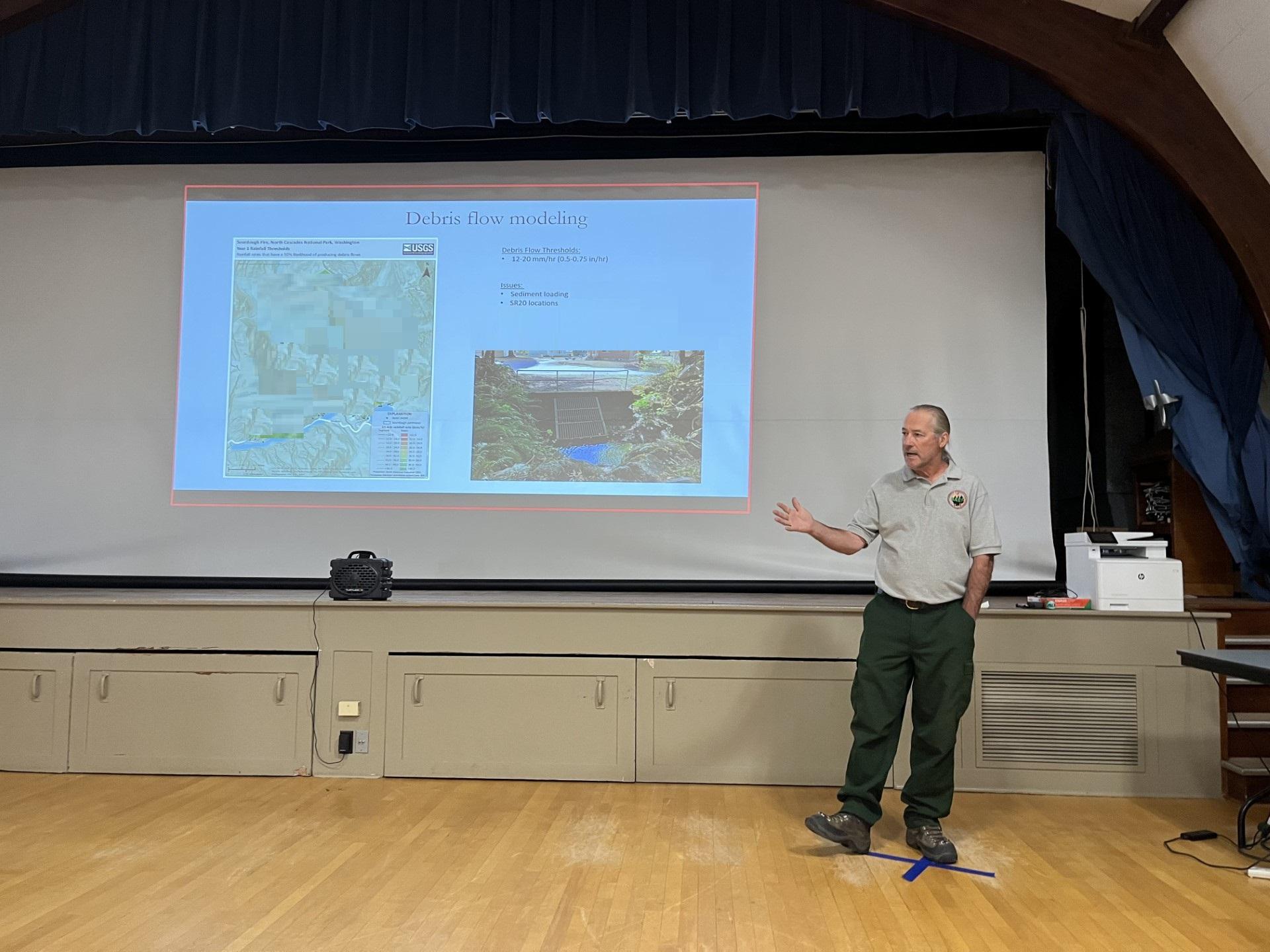
Related Incident: 2023 Sourdough Fire Burned Area Emergency Response (BAER)
Publication Type: News
A whitebark pine (Pinus albicaulis) stand is a magical place. Perched on high ridges and rocky talus slopes, these trees act as lookouts for the rest of the ecosystem, their trunks stretching toward the sky. The smell of sun-warmed pine needles, the call of Clark's nutcrackers claiming their territories, and the subtle glow of blooming mountain flowers invoke a sense of wildness on a summer day.
Conifers, or cone-bearing evergreen trees, dominate the forests of the North Cascades, including in the Sourdough Mountain area. These forests are complex with many species of conifers, deciduous broad-leaved trees, woody shrubs, and ferns. This landscape provides shelter and food for diverse wildlife, from the small birds that nest in shrubs to the young trout that eat insects. In this ecologically diverse area, the whitebark pine is one species of particular concern during wildfires.
Whitebark pine is a keystone species of sub-alpine ecosystems in western North America. It grows in nearly homogeneous stands on harsh, dry terrain and can also be found growing with other subalpine conifers in moister, protected sites. It is often the first tree species to establish in places unfriendly to other plants. Once present, whitebark pine creates habitat that is favorable to other species, which enables forest succession and increases subalpine diversity. Whitebark pine occupies a special niche in the ecosystem and its unique habitat preferences put it at greater risk of mortality after a wildfire. Due to declining populations and persistent ecological threats, the species received Endangered Species Act protection as a Threatened species in December 2022.
Whitebark pine is an important species in North Cascades National Park Service Complex (the Complex) ecosystems. The tree’s nuts are a dominant food source for Clark’s nutcracker (Nucifraga columbiana) and an important protein source for bears. In eating the nuts, the nutcracker acts as a primary seed distributor across the landscape, caching dozens of pine nuts in burnt areas, where it prefers to hide its meals. Sometimes these caches aren’t eaten, like in instances when the bird dies or the bird has an overabundance of seasonal food. When caches are left, bears will often come to reap the rewards of the bird’s planning, benefiting from the high protein content. When the caches go untouched by birds, bears, or other animals; the seeds will hopefully germinate to create new stands of whitebark pine.
Populations of this species have been drastically affected by white pine blister rust (Cronartium ribicola), an invasive fungus that was introduced to North America in the 1900s. This fungus causes infections in trees that create injuries, called cankers, on branches and stems. Cankers damage the tree’s tissue and stop the transport of photosynthetic products and nutrients throughout the tree. The appearance of cankers will eventually lead to death of the branch, part of the tree, or the whole tree. Blister rust may also impact reproduction by weakening or killing cone-bearing branches.
Another existing threat to whitebark pine is the mountain pine beetle (Dendroctonus ponderosae). These beetles usually attack mature whitebark pine and can quickly decimate stands. Bark beetles lay eggs under the bark and, when the eggs hatch, the larvae mine the area beneath the bark and eventually cut off the tree's nutrient supply. The warming climate has enabled mountain pine beetles to reproduce in one-year, rather than multi-year, cycles and they are particularly attracted to fire-impacted habitat due to the presence of stressed trees. The beetles also carry a fungus that causes dehydration and inhibits a tree's natural defenses against beetle attacks.
More frequent and higher-intensity fires that have occurred in the North Cascades Range over the last decade pose a compounded threat to the area’s whitebark pine populations. Whitebark pine is moderately fire-adapted, so individuals can usually endure low to moderate intensity wildfire. However, individual trees have been weakened by stressors like the blister rust fungus, making them less likely to survive a fire. Decades of fire suppression have also put the tree at risk. Spaces between individual trees have filled with smaller, shade-resistant species that act as fuel to carry a wildfire, like the Sourdough, and cause it to burn hotter.
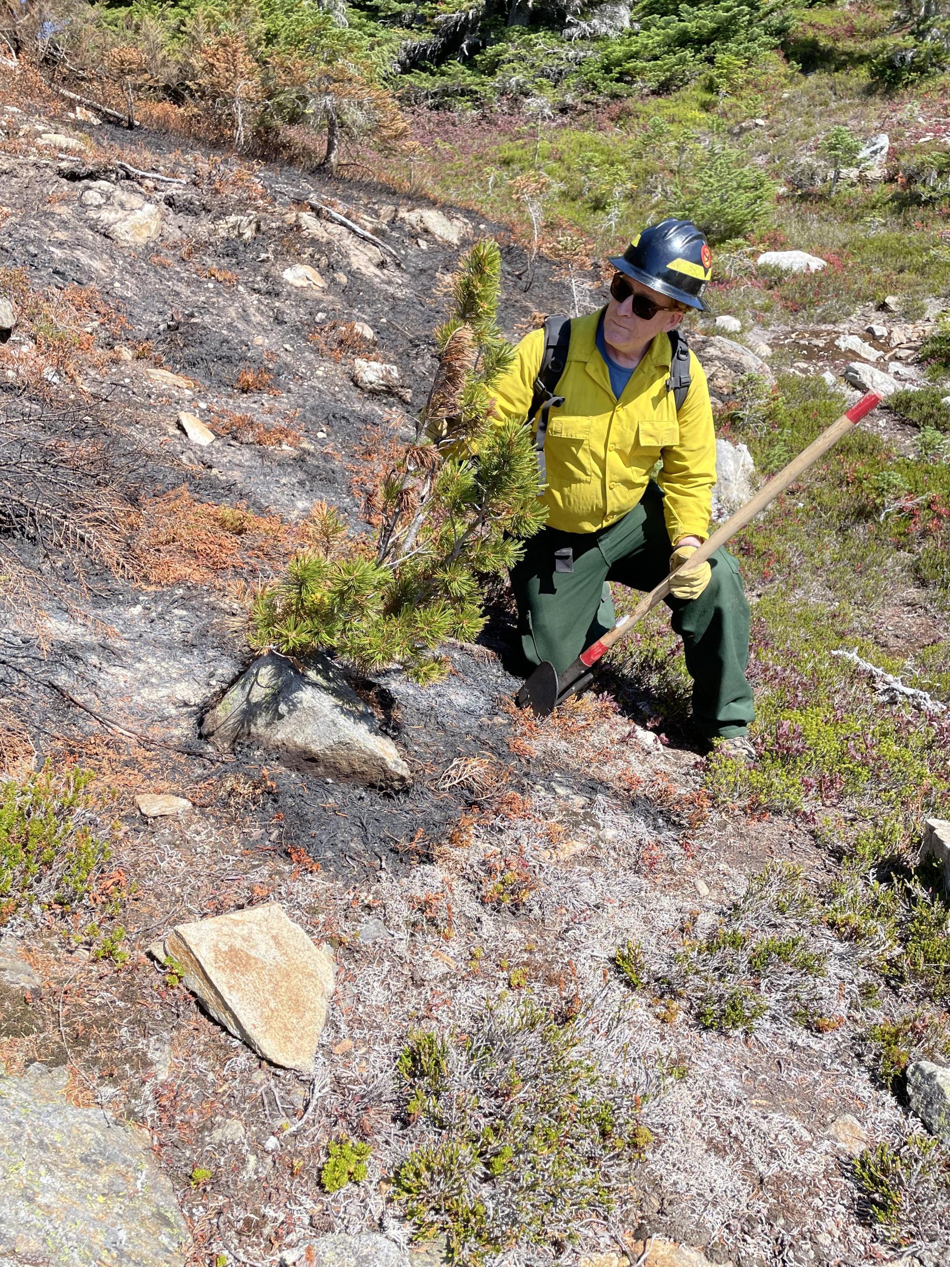
The Sourdough Burned Area Emergency Response (BAER) team includes a forester, fire ecologist, vegetation ecologist, and botanist with relevant knowledge and experience, many of whom live and work in the North Cascades. These subject-matter experts have been researching and collecting data to provide appropriate whitebark pine management recommendations to park management.
Though Sourdough Creek and Stetattle Creek drainages don’t have large or concentrated populations of whitebark pine, that makes the small number of individuals in the area even more important. The team identified where whitebark pine exists within the Sourdough Fire footprint and surveyed individual trees for damage by collecting data on where and how severely a tree was burnt. Some of the trees in the area were burnt, but others were spared in unburnt “islands” within the fire footprint. Scientists observed at least one tree mortality from scorch and several other burnt trees that may survive. Whitebark pine prefers direct light, so the surviving trees will benefit from increased sunshine, but these trees will see more challenges than benefits. Threats like mountain pine beetle and white pine blister rust now pose greater threats to these physiologically stressed trees.
The BAER team will consider how to protect and support these small populations so that the ecosystem can fully rebound. They will make recommendations to park managers at the Complex, who may spend years engaged in the restoration activities recommended by the team. Ecologic effects last long after a fire is out and the BAER team is dedicated to providing a path to mitigate them.
BAER Tales A Dynamic Duo Blazes a Path for the Team
Related Incident: 2023 Sourdough Fire Burned Area Emergency Response (BAER)
Publication Type: News
Like all successful teams, the Burned Area Emergency Response (BAER) team on the Sourdough Fire benefitted from strong leadership. Jack and Cedar formed a dynamic duo to support each other during this short but intense assignment. Jack stepped in to lead the team and Cedar served as the team’s deputy lead and document specialist. BAER leadership combines their shared passions for protecting natural and cultural resources with post-fire mitigation actions to protect those resources after the fire event has passed.
Jack retired after a long career with the National Park Service (NPS), most recently as the Chief of Natural and Cultural Resources at the North Cascades National Park Service Complex (the Complex). He nerds out about wilderness character and the effort to restore grizzly bear populations in the Pacific Northwest. Jack discovered BAER as he served multiple roles on fire assignments but yearned for deeper involvement. He wanted to contribute to a comprehensive wildfire management strategy that minimally impacted resource values on the land. He stumbled upon a BAER poster in an NPS office and his involvement grew from there.
Cedar has a lot of passion for what he does and is particularly concerned with the fire-related impacts of climate change, especially those on vegetation. His master’s degree in Fire Ecology and Restoration Ecology supports his work as an Ecologist with the National Park Service’s Pacific West Region Office of Fire and Aviation Management. He has 20 years of experience working in wildland fire, with 13 of those spent leading the North Cascades National Park Fire Effects Monitoring Crew. Cedar was introduced to BAER during his time as a Lead Resource Advisor (READ). In this role, he regularly collaborated with the BAER team on NPS wildland fire incidents. He delights in the opportunity to research the effects of fire on natural and cultural resources across scale and time, especially as it applies to wilderness and large, old trees.
Cedar and Jack enjoy the challenge of coordinating a diverse team of experts. The Sourdough BAER team gathered from across the country on short notice. Jack and Cedar coordinated the spatial logistics of where team members would work, eat, and sleep. The establishment of a BAER team happens quickly. These experts understood the assignment, were available within two days’ notice, and quickly formed collaborative working relationships to get the job done. The team prepared a blueprint for the Complex to quickly address the potential threats to human life and property and the impacts of the fire on natural, cultural, and infrastructure resources after the Sourdough Fire.
Jack was able to flex his strongest BAER muscle on this assignment as the Sourdough BAER Team Lead: building a robust BAER team. Each BAER incident is highly unique and requires specialists with specific skills. The Sourdough BAER team included scientists with specialties relevant to the incident at North Cascades National Park Service Complex including archeology, hydrology, botany, forestry, wildlife, fire ecology, and geo-spatial systems. Once the team was assembled and assigned, Jack led the team on a daily basis. He patiently oversaw field work, information analysis, summary assessment writing, and funding requests. In addition to leading the team, Jack completed recreation assessments. He evaluated the damage to trails and recreational facilities that had been caused by the fire itself, then determined policy-compliant costs to repair or replace those facilities. Due to the wilderness character at the Complex, he enjoyed hiking many miles of trails to understand how the infrastructure fared during the Sourdough Fire.
Cedar supported logistics, planning, administration, coordination, and communication for the team. As the document specialist, he built and managed the BAER Plan and synthesized other information. He typed away in the team’s makeshift office; documenting work, organizing data, solving problems, managing logistics, and writing technical reports. Though most of his work was in the office, he was able to provide subject-matter expertise in the field by collecting data on some of the affected tree species. He surveyed the Sourdough Ridge for fire impacts to whitebark pine, conducted a helicopter survey on Stetattle Creek, and surveyed old-growth forests for burn impacts.
Jack and Cedar feel grateful to have witnessed the powerful force of fire on a landscape and to rise to the challenge of mitigating negative fire effects. The Complex has a tremendous diversity of plants, ecotones, and wildlife. They encourage visitors to learn the science of how an ecosystem will respond to fire and how and why land managers must find ways to mitigate some fire effects or mitigate the negative consequences that follow a fire.