
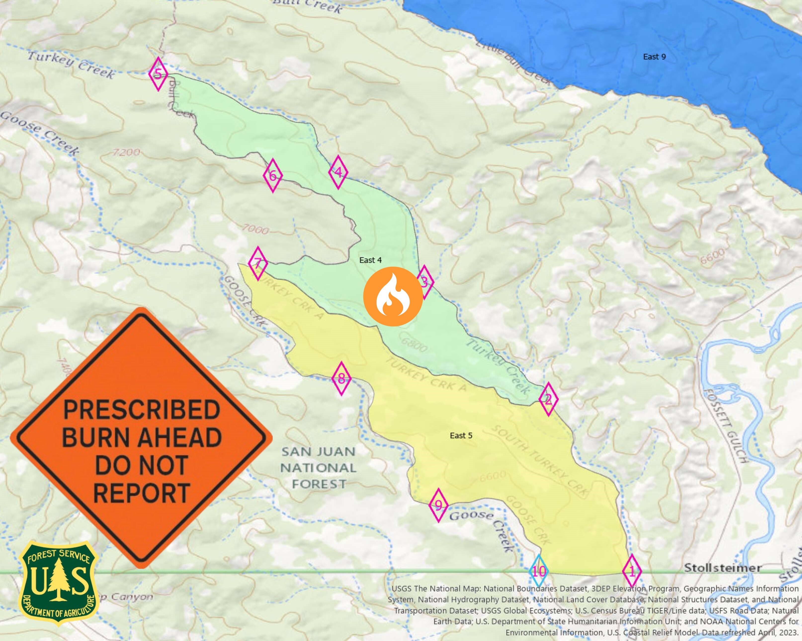
Columbine District Southern HD Unit Prescribed Fire East 4 Block 09212023
Related Incident: 2025 San Juan National Forest Prescribed Fire Program
Publication Type: News
Ignitions for the prescribed burning operation continue today, September 21, 2023, on the East 4 Block within the Southern HD Unit of the #SanJuanNF. Resources are looking to complete the remaining 300-acres from yesterday's burn goal of 500-acres. Today's operation is located west of Turkey Creek and east of Goose Creek on the southwestern end of the #SanJuanNF. Crews are looking at a 12-1pm ignition, weather and fuel conditions permitting. If you are in the area, please exercise caution when around firefighters and fire apparatuses. Some smoke may be visible in the area.
60 firefighters will work to execute this prescribed fire, aimed at reducing hazardous ground fuels, reducing the risk of unplanned catastrophic wildfire, restoring ponderosa pine ecosystems, and improving wildlife habitat.
Prescribed fires planned on Carpenter Ridge and West Dolores Rim September 2023
Related Incident:
Publication Type: Announcement
Prescribed fires planned on Carpenter Ridge and West Dolores Rim
The Bureau of Land Management (BLM) plans to conduct prescribed fire treatments this fall in the Tres Rios and Uncompahgre field offices. Firefighters will reintroduce fire to a fire-adapted ecosystem in a controlled manner to protect Ponderosa pine stands, enhance wildlife habitat, restore healthy forests and species diversity, and maintain a fire-resilient landscape.
The Carpenter Ridge project area is located two miles outside of Paradox Valley, CO, between Q13 and R3 roads (Rimrocker Trail route). Firefighters plan to burn 200 acres of oak brush and pine tree litter. This project is planned to start the week of September 25th. The Rimrocker trail, Q13 and R5 roads will remain open but may experience some smoke impacts throughout the burning period.
The West Dolores Rim project area, locally known as the “East and North Pines,” is located seven miles east of Dove Creek. Firefighters will use hand ignitions and Unmanned Aircraft System (UAS) on 1,200 acres of pine needle cast and mountain brush leaf litter. This project may start as early as September 22nd and will take multiple days to complete treatment.
Prescribed fire mimics natural processes under appropriate weather and vegetative conditions, which improves forage for wildlife, increases plant diversity by creating breaks in the understory where native grasses and forbs can thrive, and effectively reduces hazardous vegetation while enhancing woodland health.
The projects are part of the BLM’s ongoing commitment to protect human health and safety while maintaining or enhancing forest and woodland health and functionality. The BLM obtained smoke permits from the Colorado State Air Pollution Control Division, which identify atmospheric conditions under which the burns can be implemented. Prescribed fire smoke may affect your health. For more information, visit CO Dept of Public Health & Environment - Wood smoke and health.
More information on Southwest District prescribed fuel treatments at InciWeb_Southwest District BLM Prescribed Fire and follow our Facebook-BLM Southwest District or Twitter-@SWD_Fire pages.
Olympic National Park Fire Update September 20
Related Incident: 2023 Olympic National Park Lightning Fires
Publication Type: News
Port Angeles, Wash. – Thanks to modest overnight precipitation and cloud cover, minimal fire activity was observed today. This allowed crews to insert personnel and prepare for the upcoming dry period.
Fire crews moved into areas north of the Delabarre fire to bolster numbers and prepare for structure protection operations tomorrow. Minimal activity, such as smoldering and creeping, was observed. Helicopters ran a cycle of buckets in anticipation of the coming warm, dry period.
Fire Name
Initial Report
Estimated Size as of 9/5
Location
Hurricane
8/28/23
4 acres
2,000 ft below Hurricane Ridge parking area
Eagle Point
8/28/23
123 acres
~5 miles out Obstruction Point Road
Diamond Mountain
9/1/23
30 acres
3.3 miles NE of
Anderson Pass
Low Divide
9/1/23
312 acres
N. Fork Quinault drainage
Delabarre
9/1/23
3,554 acres
3 miles SE of Mount Christie
Martins Lake
9/2/23
108 acres
2 miles NE of Mount Christie
Mount Queets
9/14/23
4 acre
Summit of Mount Queets
Fire is an integral part of the forested ecosystems on the Olympic Peninsula; plants and animals here have evolved with fire for thousands of years. Many factors such as weather, topography, and vegetation influence fire behavior and the effects that fires have on natural resources.
Background Information
All seven active fires in Olympic National Park ignited when a series of lightning strikes occurred on the Olympic Peninsula in the afternoon on August 28.
Closures
Due to wildfire activity the following closures are in effect until further notice:
- Elwha River Trail from Elkhorn to Low Divide
- Hayden Pass Trail
- Dosewallips River Trail from Dose Meadows to Hayden Pass
- Dodger Point Way Trail
- North Fork Quinault Trail from Elip Creek trail junction to Low Divide
- Skyline Trail from Elip Creek Trail junction to Low Divide
- Martin Park Trail
- Obstruction Point Road and Trailhead
Olympic National Park Wilderness Information Center (WIC) will be notifying backcountry permit holders who may be impacted by these closures. Any permit holders who plan to backpack in the above impacted areas should contact the WIC at 360-565-2992 or by emailing OLYM_WIC@nps.gov.
Weather and Fire Behavior
Fire activity may increase tomorrow and Friday due to predicted warm temperatures, instability, and low relative humidity values. Rain is expected to return Friday evening and continue through the weekend.
Information for the 2023 Olympic National Park Lightning Fires can be found at: https://inciweb.wildfire.gov/incident-information/waolp-2023-olympic-national-park-lightning-fires
Olympic National Park information: www.nps.gov/olym
Olympic National Forest information: www.fs.usda.gov/olympic
State and county area burn bans: https://ecology.wa.gov/Air-Climate/Air-quality/Smoke-fire/Burn-bans
South Fork Complex Update September 21 2023
Related Incident: South Fork Complex
Publication Type: News
South Fork Complex Update
Thursday, September 21, 2023
Fire Information: 208-510-7856, 8 a.m. to 8 p.m.
Email: 2023.southforkcomplex@firenet.gov
Linktree: https://linktr.ee/2023southforkcomplex
3-9 Fire: 2,840 acres with 85% containment
Pellitreau Fire: 3 acres with 100% containment
Pilot Fire: 1,055 acres with 100% containment
Sulphur Fire: 31 acres with 100% containment
3,929 acres and 90% overall containment for the South Fork Complex
A total of 184 personnel, crews, air support, engines, dozers, and water tenders support the incident.
3-9 Fire – With the expected wind gusts, engines are patrolling the fire perimeter while monitoring the interior heat. Heavy equipment and crews continue preparing for chipping operations along Route 1. The public can expect to see large dump trucks transporting the chips along Route 1 and Highway 36.
The Pilot Fire is 100% contained. Crews will continue to patrol the fire perimeter while actively engaged in suppression repair.
The Pellitreau Fire and the Sulfur Fire are 100% contained. Firefighters continue to patrol the fires periodically to ensure fire remains within containment lines.
Weather: Dry and sunny weather is expected Thursday, with humidity levels 20-30%. The cooling trend continues with afternoon highs in the upper 60 to low 70s. Winds will be northeasterly 5 to 10 miles per hour (mph) in the morning with gusts to 15 mph, becoming west northwest 5 to 10 mph gusting to 17 mph in the afternoon. Fire weather conditions are expected to remain below critical levels.
Forest Closure: Forest Closure orders for the South Fork Complex Fire continue to be in effect and are posted on the Shasta-Trinity National Forest and the Six Rivers National Forest websites. Please avoid closed areas.
Smith River Complex North Daily Update Thursday September 21 2023
Related Incident: Smith River Complex
Publication Type: News
Smith River Complex North Daily Update, Thursday, September 21, 2023
Size: 93,559 acres (12,460 ac. in Oregon); Location: Grants Pass, OR; Cause: Lightning
Containment: 76%; Start date: August 15, 2023; Total personnel: 1,475
Resources: 34 crews 6 helicopters 47 engines 7 dozers 28 water tenders 9 masticators 1 Skid Steer
Yesterday: Strong northeast winds were experienced over the fire area and the perimeter containment lines held the fire in place. The interior island of unburned ground, located in the Utility division, experienced two small spot fires that crews quickly extinguished and will continue to monitor. The high winds prevented the use of helicopters to assist with remote-area backhaul operations. However, ground-based backhaul operations and suppression repairs continued. Fire crews worked diligently to gain more containment along the north perimeter.
Today’s Activities: Crews will continue to patrol and secure the north and northwest edges of the fire perimeter. Heavy equipment crews will continue working the secondary containment line to the west along Forest Road 1106. Suppression repair will be ongoing near Monkey Ridge and Sanger Peak and backhaul operations continue. Strong northeast winds are expected again today that are forecast to bring 30 to 40 mph gusts on the ridge tops. Fire managers and firefighters are prepared to hold the fire line wherever these impacts will be experienced.
Evacuations: The Josephine County Sheriff has set the evacuation status to Level 1-BE READY. This level will remain until significant rainfall is received. This includes the area west of US-199 in Josephine County, including the community of O’Brien and to the Oregon-California border. If you have internet access, you can monitor the Rogue Valley Emergency Management site. You can also sign up for evacuation alerts, updates and see an interactive Fire First Response Map with evacuation areas here: https://rvem.org/.
Smoke: NE winds will continue to transport smoke from the Smith River fire toward Crescent City. Gold Beach and Brookings will experience smoke impacts from Anvil fire to the north. Smoke at Gold Beach will result in UNHEALTHY conditions. Brookings will experience moderate smoke impacts along the coast with cleaner air inland. This pattern will continue through Friday afternoon when the arrival of SW winds may bring smoke back into the area, especially at O'Brien and Cave Junction. Smoke levels can change rapidly depending on weather; check current conditions at: https://bit.ly/SWORsmoke
Area Closures: A closure is in place on the Rogue River-Siskiyou National Forest for Forest Road 1106 (South Elk Mountain Road), Forest Road 1205 (Lower Wheeler Road), and Forest Road 1983 (Mt. Emily Road) until October 31, 2023 or until rescinded. The closure allows for safe operations related to the Smith River Complex North. Closures on BLM land are in place as well. Visit bit.ly/RRSNFAlerts or https://www.blm.gov/orwafire for additional information.
Road Closures and Delays: Caltrans in Del Norte County issued a schedule of road closures and lane restrictions on US-199. Weekdays will have a combination of road closure and lane restrictions. Over the weekend, the road will remain open, but with lane restrictions and pilot cars. Expect delays. For specific information on road access, please see the Caltrans QuickMap site https://quickmap.dot.ca.gov/ and Oregon Department of Transportation’s https://www.tripcheck.com/. Local law enforcement cautions against any non-essential traffic along this route. Navigation apps and mapping programs have been routing travelers into active fire areas. Do not use forest roads as alternate routes.
Restrictions: Please respect the temporary flight restriction (TFR) established for the Smith River Complex. Keep drones away from firefighting operations and the TFR. If you fly, we can’t. Don’t be the reason a firefighting air mission has to divert! For more information on the TFR, visit https://tfr.faa.gov/.
Actualizacin del Incendio del Complejo Cowlitz 21 de septiembre de 2023
Related Incident: Cowlitz Complex
Publication Type: News
Facebook:https://www.facebook.com/cowlitzcomplex/ Twitter: https://twitter.com/GPNF
Bosque Nacional Gifford Pinchot: https://www.fs.usda.gov/giffordpinchot
Actualización del Incendio del Complejo Cowlitz
21 de septiembre de 2023
Situación actual: El Complejo Cowlitz está contenido en un 40% con un total de 715 acres y 296 efectivos. Aunque las cuadrillas siguen trabajando en la construcción de líneas de contención, la gestión del incendio está pasando a la "reparación de la extinción". Una vez que los bomberos completan las tareas de extinción, devuelven el terreno a un estado más natural. La reparación de los daños causados por la extinción de incendios consiste en una serie de medidas adoptadas tras el incendio para reparar los daños causados al terreno y reducir al mínimo la posibilidad de erosión del suelo y otros problemas que pudieran derivarse de estas actividades. Incluye los impactos causados por las líneas de mano, las líneas de dozer y los helisuperficies que se utilizaron para apoyar a las cuadrillas. Las carreteras y líneas mejoradas que crean una barrera de seguridad entre el incendio de Grassy Mountain y las comunidades permanecerán hasta que el incendio se extinga.
Mensaje sobre seguridad: Con la llegada del fin de semana, recuerde que es temporada de cacería. Si tiene previsto pasear por el bosque este fin de semana, tenga cuidado si se desplaza fuera de los senderos o por zonas remotas. Cuando vaya de excursión, lleve colores brillantes para que los cazadores puedan verle. Sea cortés con los demás recreacionistas, ya que todos están allí para divertirse.
Antecedentes:Había 30 incendios en el complejo. Los incendios se iniciaron el 25 de agosto a raíz de un rayo que cayó sobre el bosque nacional de Gifford Pinchot. Todos los incendios se gestionan con una estrategia de supresión total. La mayoría han sido contenidos. El incendio de Grassy Mountain sigue siendo la principal prioridad del equipo de gestión.
Restricciones contra incendios: Siguen vigentes las restricciones sobre incendios. Las hogueras están prohibidas en todo el Bosque Nacional de Gifford Pinchot; sólo se permiten las hogueras de propano, las estufas y las linternas. Encontrará más información en el sitio web del bosque en Gifford Pinchot National Forest - Fire Management (usda.gov). La decisión de levantar o mantener las restricciones contra incendios depende de factores como las condiciones meteorológicas actuales y previstas, la humedad del combustible, el nivel de actividad del incendio y la disponibilidad de recursos de extinción para responder a nuevas igniciones.
Cierres: Con la actividad del fuego en curso en las proximidades del Snagtooth Fire las siguientes carreteras y senderos están cerrados al público para reducir la exposición y ayudar a garantizar la seguridad pública y de los bomberos: Carreteras forestales 9300 y 9341, Boundary Trail #1 (desde Elk Pass hasta la intersección con Summit Prairie), Summit Prairie #2, Craggy Peak #3, Snagtooth #4, Quartz #5, Stabler Camp #17, Wright Meadows #80, Basin Camp #3A, Quartz #5B, Quartz #5C (French Creek), Snyder Pasture #80A. La carretera forestal 8410 está cerrada para los bomberos y la seguridad pública en las inmediaciones del incendio de Pothole, y la carretera forestal 78 está cerrada temporalmente entre el cruce de la 78 y la 22 debido a los escombros peligrosos que ruedan hacia la calzada.
Restricciones Temporales de Vuelo: Permanece en vigor un TFR durante las horas diurnas situado al norte de la US-12 hacia el Parque Nacional del Monte Rainier. La respuesta de la aviación contra incendios se detiene o retrasa si una aeronave no autorizada entra en el TFR. Las restricciones temporales de vuelo también se aplican a los sistemas de aeronaves no tripuladas o drones.
Lookout Bedrock Petes Lake Horse Creek and Pothole Fires September 21 2023
Related Incident: Lookout FireBedrock FirePetes Lake Fire2023 Horse Creek Fire
Publication Type: Announcement
Lookout, Bedrock, Petes Lake, Horse Creek, and Pothole Fires
Thursday, September 21, 2023 - Morning Update
Current Status:
Lookout Fire: Size: 25,659 acres l Start Date: August 5 l Cause: Lightning l Containment: 50%
Bedrock Fire: Size: 31,590 acres l Start Date: July 22 l Cause: under investigation l Containment: 98%
Petes Lake Fire: Size: 3,144 acres l Start Date: August 25 l Cause: Lightening l Containment: 0%
Horse Creek Fire: Size: 763 acres l Start Date: August 24 l Cause: Lightning l Containment: 100%
Pothole Fire: Size: 109 acres l Start Date: August 25 l Cause: Lightning l Containment: 100%
Total Personnel: 897
Total Assigned Resources: 37 engines l 23 crews l 7 dozers l 31 water tenders l 16 masticators l 7 helicopters
Suppression: During a large fire suppression effort, it is common to have firefighters working both day and night to take suppression actions in order to protect lives and property. With the increased relative humidity, precipitation, and lower temperatures – along with the direct and indirect suppression activities that have occurred over the life of these fires – Wednesday night was the last operational shift for our night shift resources. Many of those resources will continue to work on suppression repair efforts across all of the fires during the day shift.
The only remaining areas where firefighters are engaged in suppression activities are along the north side of the Lookout Fire, southeast of Carpenter Mountain and the eastern edge of the Petes Lake Fire, on the west side of the Cascade Lakes Highway. The Horse Creek Fire and the Pothole Fire are in patrol status where firefighters monitor the containment lines to ensure they continue to hold the fire within its final footprint.
Suppression Repair: All of the firefighting resources not engaged in suppression actions are actively working on suppression repair efforts on the Lookout Fire, Bedrock Fire, Horse Creek Fire, and Petes Lake Fire. In addition to being 100 percent contained, all of the suppression repair efforts have been completed on the Pothole Fire. Due to the large size of the Lookout Fire and the Bedrock Fire in particular, suppression repair efforts are expected to continue for the weeks ahead. These activities are initiated as soon as it is safe to do so – often even when firefighters are still suppressing the fire. Firefighters continue to work closely with the Resource Advisors to mitigate the damage to natural and cultural resources caused by the emergency suppression efforts. Some of the continued activities being completed include stabilizing soils along dozer and handlines constructed as control features to limit fire growth, ensuring culverts and ditches are cleared for the coming rains, and removing woody debris accumulated on the forest floor as it was removed to starve the fire of available fuel.
Burned Area Emergency Rehabilitation (BAER): A completed assessment of the Bedrock Fire is expected to be released today. One of the products developed by the BAER team is a soil burn severity map which takes into account not only the effects of the Bedrock Fire on the soil conditions, but the cumulative effects of multiple fire scars within the Bedrock Fire footprint. The BAER assessment report will help guide long-term recovery efforts, in addition to the emergency rehabilitation efforts that will begin in the short-term. The BAER team will begin their assessment of the Lookout Fire, Horse Creek Fire, and Pothole Fire next week.
Weather: Overnight lows ranged from the middle 30s to low 40s. There is a 30 percent chance of rain again on Thursday; most likely occurring near the Petes Lake Fire. Temperatures are expected to be about 5 degrees warmer than Wednesday before dropping later in the week. There is a stronger chance of wetting rain towards the end of the week and beyond. The cooler weather and precipitation have decreased fire behavior, with little to no growth expected on any of the fires.
Linn County Evacuations: Visit the Linn County Wildfire map for current evacuation information.
Lane County Evacuations: Visit the Lane County Lookout Fire Evacuation Areas map for current evacuation information.
Deschutes County Evacuations: Visit the Deschutes County Emergency Information map for current evacuations information.
Forest Closures: Emergency closure orders remain in place for the Willamette National Forest and the Deschutes National Forest. For information on Oregon hunting regulations and these forest closures, contact Oregon Department of Fish and Wildlife at (503) 947-6000.
Restrictions: Fire Restrictions are in place on the Willamette National Forest and Deschutes National Forest. Temporary Flight Restrictions remain in place over the Bedrock and Lookout Fire areas.
Smoke Outlook: A smoke outlook for West-Central Oregon includes the Lookout, Bedrock, Petes Lake, Horse Creek, and Pothole Fires. Another source for air quality information is the Fire and Smoke map from airnow.gov.
Fire Information:
Email: 2023.lookout@firenet.gov
Phone: 541-215-6735 (8 a.m. - 8 p.m.)
Facebook:
InciWeb:
Cowlitz Complex Daily Update for September 21 2023
Related Incident: Cowlitz Complex
Publication Type: News
Facebook: https://www.facebook.com/cowlitzcomplex Twitter: https://twitter.com/GPNF
Gifford Pinchot National Forest: https://www.fs.usda.gov/giffordpinchot
Cowlitz Complex Fire Update
September 21, 2023
Current Situation: The Cowlitz Complex is 40% contained with a total of 715 acres and 296 personnel. Although crews continue to work on constructing containment lines, managing the fire is shifting to “fire suppression repair.” After firefighters complete the suppression efforts, they restore the land to a more natural condition. Fire suppression repair is a series of post-fire actions taken to repair impacts to the land and minimize the potential for soil erosion and other issues that might arise from these activities. It includes impacts caused by hand lines, dozer lines, and helispots that were used to support the crews. Improved roads and lines that create a safety barrier between the Grassy Mountain Fire and communities will remain until the fire is out.
Safety Message: With the weekend coming, please remember that it is hunting season. If you are planning to recreate on the forest this weekend, be mindful if you are travelling off trail or in remote areas. While hiking, wear bright colors so hunters can see you. Be courteous to fellow recreationists as everyone is there to enjoy themselves.
Background: There were 30 fires in the complex. The fires started August 25 after a lightning event across the Gifford Pinchot National Forest. All fires are managed under full suppression strategy. Most have been contained. The Grassy Mountain Fire continues to be the management team’s main priority.
Fire Restrictions: Fire Restrictions remain in effect. Campfires are prohibited across the Gifford Pinchot National Forest – only propane-fueled fire pits, stoves and lanterns are allowed. Additional information is available on the forest’s website at Gifford Pinchot National Forest - Fire Management (usda.gov). The decision to lift or maintain fire restrictions depends on factors such as current and expected weather conditions, fuel moisture, the level of fire activity, and the availability of firefighting resources to respond to additional ignitions.
Closures: With the ongoing fire activity in the vicinity of the Snagtooth Fire the following roads and trails are closed to the public to reduce exposure and help ensure public and firefighter safety: Forest Roads 9300 and 9341, Boundary Trail #1 (from Elk Pass to intersection with Summit Prairie), Summit Prairie #2, Craggy Peak #3, Snagtooth #4, Quartz #5, Stabler Camp #17, Wright Meadows #80, Basin Camp #3A, Quartz #5B, Quartz #5C (French Creek), Snyder Pasture #80A. Forest Road 8410 is closed for firefighter and public safety in the vicinity of the Pothole Fire, and Forest Road 78 is temporarily closed between the 78 and the 22 junction due to hazardous debris rolling out onto the roadway.
Temporary Flight Restrictions: One TFR remains in effect during daylight hours located north of US-12 to Mount Rainier National Park. Fire aviation response is halted or delayed if an unauthorized aircraft enters the TFR. Temporary flight restrictions also apply to unmanned aircraft systems or drones.
Lowline Fire Update Sept 21 2023
Related Incident: Lowline Fire
Publication Type: News
Lowline Fire Update
Gunnison, Colorado, Sept, 21, 2023
Name: Lowline Fire
Location: 14 miles north-northeast of Gunnison, Colorado, 11 miles southwest of Crested Butte, Colorado. Located on a ridge at 9400 ft elevation between Squirrel and Mill Creeks, 3.5 miles west of County Road 730, Ohio Pass Road.
Size: 1999 Acres
Cause: Lightning
Jurisdiction: USFS
Containment: 55%
The Lowline Fire continues to hold on the ridgeline between Squirrel Creek and Mill Creek drainages and along Middle Creek. Recent aerial mapping of the Lowline Fire indicates that the fire is now at 1999 acres, with some growth occurring along the western edge of the fire toward the wilderness area. Smoke continues to be visible from County Road 730 and Ohio Creek and will likely persist until the area receives a season-ending weather event.
Firefighters continue to monitor fire activity and remain prepared to take action should fire activity change. Residents can expect structure protection infrastructure such as sprinkler systems, pumps and water storage tanks to remain in the area until a season-ending weather event occurs.
The Lowline Fire is a long-duration wildfire event that is currently being administered under a “confine and contain” management strategy. Using this strategy, firefighters concentrate their fire suppression and containment efforts around the values at risk to the north, east and south of the Lowline Fire. On the western edge of this fire, the goal is to confine fire growth toward the wilderness boundary, where fire can be helpfully utilized toward forest health and future fire suppression needs. This management strategy is also a safer and more effective use of firefighting personnel, as the western area of the Lowline Fire presents a significant safety risk to firefighters due to heavy amounts of dead and downed trees. Firefighter and public safety remain our priorities.
In the interest of public safety, area closures remain in effect and are expected to remain in place until a season-ending weather event occurs in the fire area. More information is located here.
All evacuation notices have been lifted for the Lowline Fire. However, the area along Mill Creek and County Road 727 remains in pre-evacuation status. Area residents should remain informed of evacuation and pre-evacuation status as determined by Gunnison County. Evacuation information is located here.
For Lowline Fire update information, contact the Gunnison Ranger District: (970) 641-0471.
For additional information:
GMUG National Forests Fire Information Hotline: (970) 874-6602
GMUG National Forests website: www.fs.usda.gov/gmug
West Slope Fire Information website: www.WestSlopeFireInfo.com
GMUG Fire Info Facebook: https://www.facebook.com/GMUGFireInfo
Twitter: https://twitter.com/GMUG_NF
Elizabeth Fire Daily Update 92123
Related Incident: Elizabeth Fire
Publication Type: News
Information: Hours: 8:00 AM – 8:00 PM Phone: 318-239-9263 Email: 2023.TigerIsland@firenet.gov
Louisiana Statewide Burn Ban: The State Fire Marshal’s Office’s order prohibiting ALL private burning and the Louisiana Department of Agriculture and Forestry ban on all agricultural burning, remain in effect. These are reevaluated weekly. Open burning with exposed flames is prohibited with no exceptions. The use of prescribed fires is also banned. More information is available at http://sfm.dps.louisiana.gov/doc/press/pr_2023-36.pdf
Highlights: All four fires continue to have reburning in interior locations where needle cast continues to fall and hot spots remain due to heavier fuels. Multiple helicopters are providing water drops to cool areas of reburn, and ground crews continue to clear needle cast from containment lines and work inward from fire area perimeters to suppress hot spots and reburn. Hot spots continue to persist in hardwood drainages and are being monitored closely since there is a potential for more active fire behavior and spread along these drainages. Snag trees with weakened root systems are a major safety concern for crews as they work in the interior of the burn areas. The Southern Area Gold Team will transition with the Southern Area Blue Team and assume command on Saturday morning.
Tiger Island Fire: 31,290 acres, no change | 84% containment| 117 personnel assigned
Inciweb: https://inciweb.nwcg.gov/incident-information/lalas-tiger-island-fire
Facebook: https://www.facebook.com/TigerIslandFire
Hwy 113 Fire: 7,124 acres, no change | 95% containment | 37 personnel assigned
InciWeb: https://inciweb.nwcg.gov/incident-information/lalas-hwy-113-fire
Facebook: https://www.facebook.com/TigerIslandFire
Lions Camp Road Fire: 785 acres, no change | 91% containment | 7 personnel assigned
InciWeb: https://inciweb.nwcg.gov/incident-information/lalas-lions-camp-road-fire
Facebook: https://www.facebook.com/TigerIslandFire
Elizabeth Fire: 940 acres, no change | 100% containment | 5 personnel assigned
InciWeb: https://inciweb.nwcg.gov/incident-information/lalas-elizabeth-fire
Facebook: https://www.facebook.com/TigerIslandFire
Equipment resources assigned to the fires include Type 6 Engines; Dozers; Tractor Plow Units; and Water Tenders. Aerial resources include helicopters and fixed wing aircraft. Additional support is being provided by Parish authorities and departments; Sheriff’s Offices; and the Governor’s Office of Homeland Security and Emergency Preparedness.
Weather & Fire Behavior: High temperatures in the low to mid 90s and slightly higher relative humidity near 35% are forecast for this afternoon. Southeast winds of 5 to 10 mph with gusts into the teens are expected. Fuel moistures remains critically low for all fuel types with smaller fuels in the 6 to 9% range. Heavier fuels are very low with 10 to 15% fuel moisture due to the long-term EXCEPTIONAL /EXTREME drought conditions. The combination of weather and fuel moisture provides the potential for moderate to high fire behavior to continue.
Air Quality: Smoke may occur in areas of reburn. Air quality information is available at the EPA’s Fire and Smoke Map at: https://fire.airnow.gov/ .
Temporary Flight Restriction: A Temporary Flight Restriction (TFR) is in place over the Tiger Island Fire and Hwy 113 and Elizabeth Fire areas. If you fly, we can’t. Aircraft or drone intrusions into the restricted airspace endangers aircrews conducting fire operations and aerial resources are grounded for safety. This unnecessarily places aircrews and ground fire crews at risk in a dynamic and dangerous fire environment.