
Tiger Island Fire Daily Update 92223
Related Incident: Tiger Island Fire
Publication Type: News
Information: Hours: 8:00 AM – 8:00 PM Phone: 318-239-9263 Email: 2023.TigerIsland@firenet.gov
Louisiana Statewide Burn Ban: The State Fire Marshal’s Office’s order prohibiting ALL private burning and the Louisiana Department of Agriculture and Forestry ban on all agricultural burning, remain in effect. These are reevaluated weekly. Open burning with exposed flames is prohibited with no exceptions. The use of prescribed fires is also banned. More information is available at http://sfm.dps.louisiana.gov/doc/press/pr_2023-36.pdf
Highlights: All four fires continue to have reburning in interior locations where needle cast continues to fall and hot spots remain due to heavier fuels. Hot spots persist in hardwood drainages and there is a potential for more active fire behavior and spread along these drainages. New hotspots are located daily as some are buried under sandy soil and infrared sensors may not detect them from one day to the next. Multiple helicopters are providing water drops to cool areas of reburn, and ground crews continue to clear needle cast from containment lines and work inward from fire area perimeters to suppress hot spots and reburn. Snag trees with weakened root systems are a major safety concern for crews as they work in the interior of the burn areas. The Southern Area Gold Team will shadow the Southern Area Blue Team today and assume command on Saturday morning.
Tiger Island Fire: 31,290 acres, no change | 84% containment| 115 personnel assigned
Inciweb: https://inciweb.nwcg.gov/incident-information/lalas-tiger-island-fire
Facebook: https://www.facebook.com/TigerIslandFire
Hwy 113 Fire: 7,124 acres, no change | 95% containment | 38 personnel assigned
InciWeb: https://inciweb.nwcg.gov/incident-information/lalas-hwy-113-fire
Facebook: https://www.facebook.com/TigerIslandFire
Lions Camp Road Fire: 785 acres, no change | 100% containment | 7 personnel assigned
InciWeb: https://inciweb.nwcg.gov/incident-information/lalas-lions-camp-road-fire
Facebook: https://www.facebook.com/TigerIslandFire
Elizabeth Fire: 940 acres, no change | 100% containment | 5 personnel assigned
InciWeb: https://inciweb.nwcg.gov/incident-information/lalas-elizabeth-fire
Facebook: https://www.facebook.com/TigerIslandFire
Equipment resources assigned to the fires include Type 6 Engines; Dozers; Tractor Plow Units; and Water Tenders. Aerial resources include helicopters and fixed wing aircraft. Additional support is being provided by Parish authorities and departments; Sheriff’s Offices; and the Governor’s Office of Homeland Security and Emergency Preparedness.
Weather & Fire Behavior: High temperatures in the low to mid 90s and higher relative humidity of 40 to 45% are forecast for this afternoon. Light southeast winds of 5 to 10 mph with gusts into the teens are expected. Fuel moistures remains critically low for all fuel types with smaller fuels in the 6 to 9% range. Heavier fuels are very low with 10 to 15% fuel moisture due to the long-term EXCEPTIONAL /EXTREME drought conditions. The combination of weather and fuel moisture provides the potential for moderate to high fire behavior to continue.
Air Quality: Smoke may occur in areas of reburn. Air quality information is available at the EPA’s Fire and Smoke Map at: https://fire.airnow.gov/ .
Temporary Flight Restriction: A Temporary Flight Restriction (TFR) is in place over the Tiger Island Fire and Hwy 113 and Elizabeth Fire areas. If you fly, we can’t. Aircraft or drone intrusions into the restricted airspace endangers aircrews conducting fire operations and aerial resources are grounded for safety. This unnecessarily places aircrews and ground fire crews at risk in a dynamic and dangerous fire environment.
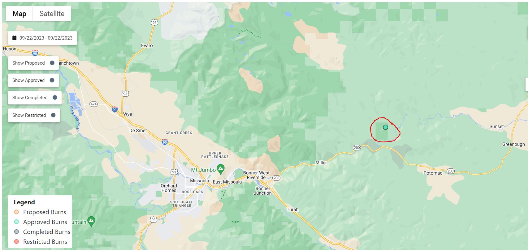
September 22 2023 Prescribed Fire Update
Related Incident: Lolo National Forest Prescribed Fire Operations
Publication Type: Announcement
Missoula Ranger District:
Pending conditions, firefighters will conduct up to 7 acres of hand pile burning in the Lower Blackfoot Corridor, east of Missoula to reduce hazardous fuels from previous vegetation management operations.
Smoke will likely be visible at times in the in the Lower Blackfoot Corridor along Highway 200.
Special Report Soil Burn Severity vs Vegetation Mortality
Related Incident: Bedrock Fire
Publication Type: Announcement
BAER Team Special Report - Soil Burn Severity vs. Vegetation Mortality
The Burned Area Emergency Response (BAER) team measures two different elements, soil burn severity and vegetation mortality, to help guide their assessment of emergency risks and imminent threats to critical values, including life and safety, Forest Service property and critical natural resources following a wildfire.
Soil Burn Severity: We tend to think of wildfire burn severity in terms of the visual impacts to above-ground vegetation, but the post-fire landscape response (erosion, flooding, and mass movement) is generally more strongly correlated to soil burn severity. Soil burn severity is a critical indicator of recovery.
Even when the soil looks lifeless, fine, hair-like roots can still persist beneath the surface. These roots not only store energy for fire-adapted plants to recover more quickly after a fire, but they also act as a net that can help stabilize the soil against erosion. When assessing soil burn severity, soil scientists examine the condition of these fine roots to help determine post-fire recovery and likelihood of erosion.
Pre-fire ground cover, forest type, fire behavior, slope, aspect, and other factors all influence soil burn severity. The BAER team’s watershed specialists (soil scientists, hydrologists, and geologists) use these factors to help ground-truth different burn intensities to tease out patterns of how fire affected and changed the properties of the soil. From the soil burn severity map, geologists can predict debris flow hazards, hydrologists can predict changes to stream flows, and soil scientists can predict erosion potential.
Vegetation Mortality: Above ground vegetation can aid in the recovery of a burned forest. For example, in areas where the trees were scorched and killed, those conifer trees will drop their needles, which provides very helpful natural ground cover. Since post-fire soil erosion is a major concern of soil scientists, this natural ground cover plays a crucial role in slowing the interaction between rain drops and soil particles that would otherwise get washed down the hillslope.
The BAER team creates a vegetation mortality map that focuses on the wildfire effects to the forest and is reported in percent of basal area loss. Basal area is the average amount of an area (such as an acre) occupied by tree stems. This product helps other scientists, such as wildlife biologists, botanists, and silviculturists understand what to expect from this changed landscape for wildlife habitat, invasive weeds, and timber production.
While lots of trees and other vegetation died, nature is resilient, and we’ve already seen evidence of many plant species sprouting up amongst the newly blackened and open canopy forest.
Olympic National Park Fire Update September 21
Related Incident: 2023 Olympic National Park Lightning Fires
Publication Type: News
Port Angeles, Wash. – Warmer temperatures and lower relative humidity contributed to a modest increase in fire behavior on Thursday. The same trend is expected for the fire area on Friday.
Fire crews moved into areas north of the Delabarre fire to monitor and protect historic cabins, trail improvements and park infrastructure. Fire activity may increase on Friday as the warm dry air mass continues over the fire area. Fire managers are shifting resources around the fires as needed to meet management goals.
Fire Name
Initial Report
Estimated Size
Location
Hurricane
8/28/23
4 acres
2,000 ft below Hurricane Ridge parking area
Eagle Point
8/28/23
123 acres
~5 miles out Obstruction Point Road
Diamond Mountain
9/1/23
30 acres
3.3 miles NE of
Anderson Pass
Low Divide
9/1/23
315 acres
N. Fork Quinault drainage
Delabarre
9/1/23
3,800 acres
3 miles SE of Mount Christie
Martins Lake
9/2/23
108 acres
2 miles NE of Mount Christie
Mount Queets
9/14/23
4 acre
Summit of Mount Queets
Fire is an integral part of the forested ecosystems on the Olympic Peninsula; plants and animals here have evolved with fire for thousands of years. Many factors such as weather, topography, and vegetation influence fire behavior and the effects that fires have on natural resources.
Background Information
All seven active fires in Olympic National Park ignited when a series of lightning strikes occurred on the Olympic Peninsula in the afternoon on August 28.
Closures
Due to wildfire activity the following closures are in effect until further notice:
- Elwha River Trail from Elkhorn to Low Divide
- Hayden Pass Trail
- Dosewallips River Trail from Dose Meadows to Hayden Pass
- Dodger Point Way Trail
- North Fork Quinault Trail from Elip Creek trail junction to Low Divide
- Skyline Trail from Elip Creek Trail junction to Low Divide
- Martin Park Trail
- Obstruction Point Road and Trailhead
Olympic National Park Wilderness Information Center (WIC) will be notifying backcountry permit holders who may be impacted by these closures. Any permit holders who plan to backpack in the above impacted areas should contact the WIC at 360-565-2992 or by emailing OLYM_WIC@nps.gov.
Weather and Fire Behavior
Fire activity may increase tomorrow due to warm temperatures, atmospheric instability, and low relative humidity values. Rain is expected to return Saturday morning and continue through the weekend.
Information for the 2023 Olympic National Park Lightning Fires can be found at: https://inciweb.wildfire.gov/incident-information/waolp-2023-olympic-national-park-lightning-fires
Olympic National Park information: www.nps.gov/olym
Olympic National Forest information: www.fs.usda.gov/olympic
State and county area burn bans: https://ecology.wa.gov/Air-Climate/Air-quality/Smoke-fire/Burn-bans
Emergency Response Team Shares SoilBurn Severity Map and Research
Related Incident: Bedrock Fire
Publication Type: Announcement
Emergency response team shares soil-burn severity map and research from Bedrock Fire
Satellite images, field surveys provide a picture
of burned areas and soil stability
Springfield, Ore. – Sept. 21, 2023 — An Emergency Response Team of resource specialists who began field surveys and an assessment of the Bedrock Fire burned areas earlier this month released its findings on Sept. 21. The Bedrock Fire, which started July 22, 2023, has covered 31,590 acres on the Willamette National Forest and adjacent private lands, and continues to smolder within established containment lines.
The Burned Area Emergency Response (BAER) Team is an Emergency Response program aimed at managing imminent, unacceptable risks to human life, safety and property, as well as threats to critical natural and cultural resources, from post-wildfire conditions. BAER Team members closely assess watersheds for post-fire, rain-related impact, such as flooding, debris-flow potential, and increased soil erosion. The team then recommends time-critical treatments to complete before the first damaging storm event.
The BAER Team soil-burn severity map for the Bedrock Fire identifies 10.8 percent of the fire area as having high burn severity and 28.5 percent with moderate burn severity. The remaining 60.7 percent has low or very low burn severity.
"Where the Bedrock Fire moved through the burn scars of the 2017 Jones and 2021 Gales fires, those reburned areas show more high and moderate soil-burn severity. Other areas that burned outside of those fire scars have only small pockets of high and moderate severity," said BAER Team Leader John Chatel.
Using the burn severity map, BAER scientists calculate expected increases in stream flows and run models to identify areas prone to erosion or landslides. "Those are the areas we focus on for protecting values at risk," Chatel said. Values at risk include public safety, roads, buildings, recreation sites, trails, historic and cultural sites, and more.
A review of the high soil-burn severity areas showed no ground cover, powdery grey or white ash present and no roots under the surface, which reduces the integrity of the soil. The higher the burn severity, the less likely soil is able to absorb rainfall, increasing surface runoff and risk of erosion, debris flows and flooding. In areas of moderate burn severity, specialists observed the majority of pre-fire ground cover (litter and ground fuels) was lost, but some charred material remained with gray ash. In those areas, soil structure remained intact, and in general fine roots and their structures remained, which assists in regrowth of hardwoods, plants and fungi.
A soil-burn severity map was initially generated using satellite imagery, then validated and adjusted by field surveys. The BAER Team observed that roots below the soil surface were generally unburned and providing soil stability, water was able to infiltrate into the soil at deeper depths, and soil structure was not degraded.
“There is still the risk of erosion on steeper, burned hillslopes that lack ground cover,” said Chatel. “These risks will remain for several years or longer in reburned areas until vegetation recovers.”
The BAER team is now prioritizing values at risk and developing a suite of emergency actions to mitigate potential hazards. BAER proposals focus on federal lands, but the team will be sharing information about identified hazards with other agencies later this week to help them plan for potential problems. The soil-burn severity map is available for viewing and downloading at: https://inciweb.wildfire.gov/incident-information/orwif-bedrock-fire.
For more information regarding this BAER assessment, please contact Kassidy Kern at (541) 588-2000 or Kassidy.kern@usda.gov.
Follow us on Facebook and Twitter @WillametteNF for more updates.
Forest Service News Release
Contact: Kassidy Kern
(541) 588-2000
Kassidy.kern@usda.gov
https://www.fs.usda.gov/willamette/
###
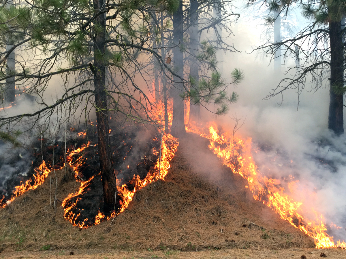
Columbine District Southern HD Unit Prescribed Fire East 4 Block 09212023
Related Incident: 2025 San Juan National Forest Prescribed Fire Program
Publication Type: News
Ignition operations have concluded for today, September 21st, on the Southern HD Unit, East 4 Block. Crews successfully completed the prescribed fire goal of 300-acres. Tomorrow, resources will transition to mop-up procedures.
Columbine District Southern HD Unit Prescribed Fire East 4 Block 09212023Mid day update
Related Incident: 2025 San Juan National Forest Prescribed Fire Program
Publication Type: News
The Southern HD Unit Prescribed Fire Project is currently underway on the East 4 Block within the USDA Forest Service - San Juan National Forest. As of 4:45pm today, September 21st, crews have completed 75% of the prescribed burn goal of 300-acres. If you are in the area, please exercise caution as firefighters and firefighting apparatuses are actively working and patrolling the fire line. Some smoke may be visible through the weekend.
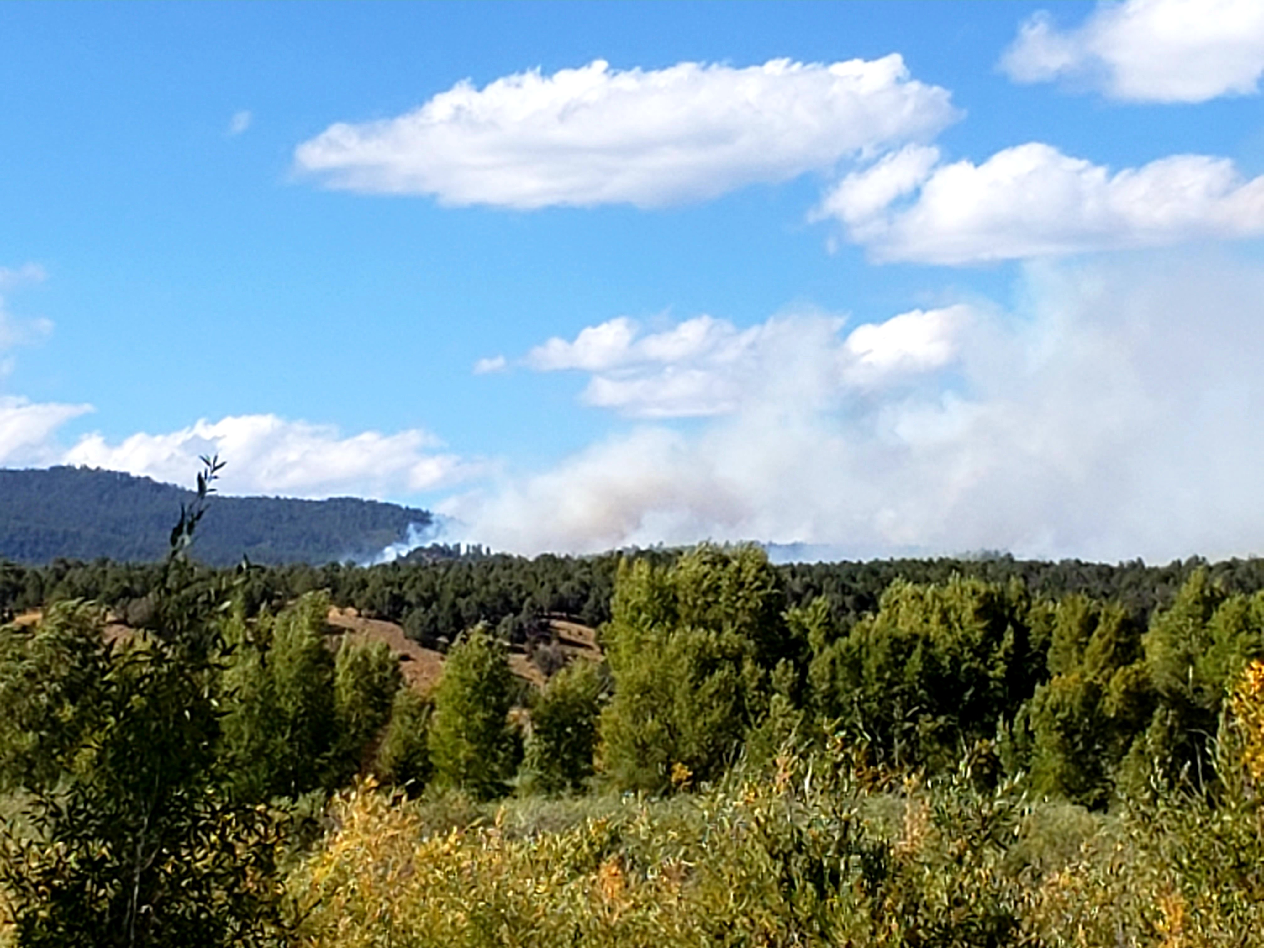
SW Oregon Smoke Outlook September 2122
Related Incident: Anvil FireFlat Fire
Publication Type: News
An air quality alert is in effect for Curry County into Thursday night.
Morgan Fire Daily Update September 22 2023
Related Incident: Morgan Fire
Publication Type: News
Morgan Fire Update: Friday, September 22, 2023
Fire Information line: 541-460-7602 8am-8pm
The Morgan Fire is burning in steep, forested terrain, approximately 21 miles northwest of Lakeview, Oregon and 8 miles north of Quartz Mountain, on both private and National Forest System lands. The fire was reported at 2:44 pm on September 18. Cause is under investigation.
Temporary Road Closure: On Thursday, the Fremont-Winema National Forest issued a temporary closure for public safety on a segment of Forest Service Road 2800, between its junction with Forest Road 3428 on the north and Forest Road 2800-016 on the south. A copy of the order and map is on the Forest website: https://www.fs.usda.gov/fremont-winema
Yesterday: Substantial rainfall and temperatures in the mid-30s aided firefighters as they worked to establish and strengthen control lines around the fire. Crews on the northwest perimeter engaged in mop up operations, and felled burned trees that pose a hazard to firefighters and the fire line. Crews around much of the eastern flank patrolled and monitored established line. On the southern flank, firefighters continued working to find control features where the fire entered steeper and more challenging terrain. An overnight shift of engines and firefighters continued suppression efforts.
Today’s Activities: Firefighters will take advantage of yesterday’s cool wet weather to build fire line directly at the fire’s edge. Operations are underway to strengthen containment lines ahead of windy weather predicted for early next week. Crews will look for opportunities to contain the southwest perimeter in the most steep and inaccessible part of the fire.
Weather: Today will be sunny with light wind and temperatures in the low 60s.
Evacuations: There is currently a Level 1 Evacuation. Evacuation maps are posted on the Morgan Fire Inciweb page and the Lake County, OR website: https://www.lakecountyor.org/
Be wildfire aware! Avoid activities that can cause an accidental spark.
https://www.readyforwildfire.org/prevent-wildfire.
Fire Information and Links
Inciweb: https://inciweb.nwcg.gov/incident-information/orfwf-morgan-fire
Facebook: https://www.facebook.com/nwteam7
https://www.facebook.com/SCOFMPFIREINFO
https://www.facebook.com/R6FWNF
2023 SRF Lightning Complex Update September 21 2023
Related Incident: 2023 SRF Lightning Complex and Redwood Lightning Complex
Publication Type: News
Fire Update
2023 SRF Lightning Complex
Thursday, September 21, 2023 – 9:00 a.m.
Eastern Area Gold Team
Brian Jenkins, Incident Commander
Information Phone: 530-536-0767
Email: 2023.lightningcomplex@firenet.gov
Information Staffing Hours: 8 am to 8 pm
This update covers 7 of the 14 fires being managed as part of the SRF Lightning Complex. The Copper Fire (2184 acres) has been absorbed by the Blue Creek #2 Fire. The remaining 6 fires (Big Foot, Blue Creek, Creek, Flat, Iron, and Merrill) totaling 34 acres, are contained and in patrol status. They are checked daily, and their size and containment are unlikely to change.
Current Situation: The 14 fires in this incident total 32,930 acres and overall containment is 7%. The seven uncontained fires described below total 30,712 acres. In total, 1,059 personnel are assigned to the incident. The strategic firing operations conducted yesterday as part of the 2023 SRF Lightning Complex were successful in reducing the dense understory, contributing to the incident management objectives of suppressing and containing the fires and protecting communities. The Blue Creek #2 Fire was more active yesterday when wind speeds increased in the evening. Fire managers continue to monitor the fire conditions and activity on all the fires. On the Pearch Fire the fire spread continued to be slow yesterday, backing down slopes with occasional single tree torching and the highest activity in areas where surface wind aligned with canyons and steep draws. Fire managers are patrolling areas for heat and may continue the firing operations if the weather stays favorable with the intent of reducing the potential for high intensity wildfires in the future.
A community meeting was held last night at the Karuk Tribe DNR Building in Orleans, CA. Representatives from the Eastern Area Incident Management Team and US Forest Service shared information on the status of the fires, the operational strategy, and the plan going forward. The speakers also spent time answering questions from the those in attendance and watching online. The meeting was available for both in-person and virtual attendees on Facebook live. The meeting was recorded and can be viewed at https://www.facebook.com/2023SRFRedwoodLightning.
Pearch Fire (8741 acres, 7% contained) – The Structure Protection Group continued to assess structures near the confluence of the Klamath and Salmon Rivers and tested the sprinklers, hose, and pump systems already in place. An Evacuation Warning is in place for those residents in the Butler Creek area (SIS-1704) which means persons in the area need to be prepared to evacuate if conditions warrant. Higher humidity levels in the morning kept fire activity subdued. The fire is hung up in Butler creek with isolated areas of heat. Fire spread to the east continued to be observed as backing and slow moving with occasional increases in fire activity with slope alignment. Crews are monitoring the fire and expect similar conditions today as yesterday with the fire backing and flanking on the north end including backing down towards Highway 96. Crews and equipment remain in place to engage the fire when it reaches these areas. Firefighters continued to assess potential ridges and locations for control lines should the fire spread to the southeast. Crews will remain on the fire during both day and night shifts.
Bluff #1 (4240 acres, 26% contained) and Mosquito (5998 acres, 9% contained) Fires – Masticator and chipping operations continued south along the Bluff Creek Road. On the south end of Bluff #1 there was minimal fire growth. Crews continued to mop up and secure the lines following strategic firing operations along the northeast end of Bluff #1. On the Mosquito Fire, firefighters continued to patrol the fire edge, seeking and extinguishing areas of heat along containment lines. Crews completed the mastication work to the south and will continue to patrol and mop up. A contingency of engines remains on both fires throughout the nighttime hours.
Blue Creek #2 (9676 acres, 0% contained) and Marlow (1961 acres, 0% contained) Fires – These fires are bounded by indirect control lines to the east and south and prior fire footprints where fuels are lighter. Fire growth was increased on Blue Creek #2 yesterday due to north winds in the evening. The Blue Creek #2 Fire has moved south and is within 900’ or so from Go Road. Blue Creek 2 and Marlow continue to be active, driven by winds interacting with terrain. No values are currently threatened. A Wildland Fire Module continues to monitor and assess conditions on the ground and air resources will monitor from above. Fire managers from the 2023 SRF Lightning Complex are coordinating daily with fire managers on the Happy Camp Complex due to the proximity of the Elliot Fire.
Monument (2 acres, 0% contained) and Let er-Buck (95 acres, 0% contained) Fires – A confinement strategy is being used to address these two fires due to limited values at risk and the remote, steep terrain with associated safety concerns for the firefighters. Terrain, natural fire barriers such as rock outcroppings, and old fire footprints where fuels are limited will be used to confine fire growth until season ending precipitation extinguishes the fires. These fires are checked regularly by aerial patrols to ensure they remain within acceptable bounds.
Weather: The drying trend is forecasted to continue through Sunday and north and northwesterly winds, when lined up with steep topography may increase variability in fire behavior. Temperatures will likewise be variable throughout the Complex area, with highs ranging from 60-80 degrees based on elevation with 60s on the ridge tops and 80s in the valleys. Wind gusts in higher terrain may gust up to 20-25 mph with gusts on exposed ridges up to 35 mph. Smoke will persist in the valleys throughout the day.
Evacuation Information
Siskiyou County Office of Emergency Services: https://www.co.siskiyou.ca.us/emergencyservices
Closures
Six Rivers National Forest: Area and campground closures are in effect on portions of Six Rivers National Forest. They can be found at: https://www.fs.usda.gov/detail/srnf/notices/?cid=FSEPRD1096395.
Additional Fire Information
Facebook: https://www.facebook.com/2023SRFRedwoodLightning
More Fire Information Links: www.linktr.ee/srffirepio
For Air Quality Information: www.airnow.gov
NOTE: For information about the Elliot or Hancock Fires which are part of the
Happy Camp Complex, please visit https://linktr.ee/happycampcomplex2023 .