
Informacin al da para los Incendios Anvil y Flat 22 de septiembre
Related Incident: Anvil FireFlat Fire
Publication Type: News
Incendio Anvil
Área: 18,691 acres | Inicio: 25 de agosto, 2023 | Localizado: 8 millas Este de Port Orford, OR | Contención: 9% | Personal: 1,256 | Recursos: 36 escuadrillas de bomberos, 8 helicópteros, 39 camiones de bomberos
El día de ayer, el incendio Anvil alcanzo un 9% de contención debido al trabajo acertado de las escuadrillas de bomberos a lo largo de Elk River Road al lado Oeste de este. Acerca de 188,000 galones de agua fueron derramados por helicópteros para apoyar a los bomberos trabajando en tierra. Los bomberos continúan fortificando líneas de contención en el lado Norte, desde Grassy Knob hasta China Peak. Retardadores de incendio fueron utilizados al lado Norte con el objetivo de reforzar las líneas que los trabajadores han construido. El lado Norte del Incendio ha estado activo debido al desplazamiento del viento. El viernes, se esperan vientos provenientes del Sur con ráfagas de hasta 40 mph sobre las cumbres.
El día de ayer, fue detectado otro incendio de menor tamaño al sur de Elk River después de que algunas brasas transportaron el calor desde el centro del incendio hacia algunas áreas cercanas.
Los bomberos se movilizaron rápidamente hacia el lugar en donde este brote de incendio fue localizado, sobre terrenos accidentadamente empinados y de una manera simultánea los helicópteros apoyaron este trabajo, derramando aproximadamente 40,000 galones de agua, logrando limitar el crecimiento del incendio. Los bomberos continuaran trabajando en la contención de este nuevo incendio y utilizaran dispositivos infrarrojos para buscar otros espacios encendidos en esta área. Las escuadrillas de bomberos permanecerán altamente vigilantes a través de toda el área afectada dependiendo de las condiciones climáticas en los próximos cambios de turnos de trabajo. Otro grupo de bomberos están trabajando en las líneas de contención de contingencia alrededor del perímetro del incendio que serán utilizadas mientras el fuego continue creciendo con dirección Oeste y Norte. El lado Este del incendio que cruza el drenaje de la carretera Forestal 5201, se encuentra ardiendo en terrenos escarpados e inaccesibles. Esta en marcha el planeamiento para la identificación exitosa de lugares en donde se puedan construir líneas de contención en las tierras vírgenes de Copper Salmon.
Evacuaciones: La Oficina del Alguacil para el Condado de curry, ha identificado cuatro zonas de evacuación alrededor del incendio Anvil. Puede encontrar información en un mapa interactivo: https://bit.ly/45UIh2E. Zonas 1 y 4 se encuentran en un Nivel de Evacuación 3 “SALGA”. Zonas 2 y 3 en un Nivel de Evacuacion 2 “PREPARESE” “Get Set“. Puede registrarse en el sistema de Alertas de emergencias para el condado: https://bit.ly/CurryCoEM
Ordenes de Cierres para ciertas áreas y carreteras: Para la seguridad de los bomberos y para el público en general, el Bosque Nacional de Rogue River-Siskiyou y la Agencia para el Manejo de Tierras en el distrito de Coos Bay, han dictado una orden de cierre para el Incendio Anvil. Puede encontrar mapas e información más detallada en: https://inciweb.wildfire.gov/incident-closures/orrsf-anvil-fire.
Incendio Flat
Extensión: 34,242 acres | Fecha de Inicio: 15 de julio, 2023 | Localizado: 2 millas Sureste de Agness, OR | Contención: 75% | Personal: 12 | Recursos: 3 camiones de bomberos
Permanece en efecto la Orden de Cierre para el Bosque nacional de Rogue River-Siskiyou. Informacion: https://inciweb.wildfire.gov/incident-closures/xx1002-flat-fire.
Informacion General
Condiciones Climáticas: El viernes por la tarde, los vientos se cambiarán hacia el Oeste, posiblemente con ráfagas en las cumbres cerca de 15 mph. Se espera una tendencia fresca para este fin de semana y se incrementa la posibilidad de lluvias. Los vientos cambiaran su dirección hacia el Sur con ráfagas de hasta 40 mph.
Teniendo en cuenta que se necesitarían cantidades de lluvia significativas o nieve para poder contener completamente ambos incendios, aun cierta cantidad de lluvia sería un alivio y ayudaría a los bomberos en el esfuerzo de contención. Un experto en meteorología se encuentra trabajando cercanamente con los manejadores del incendio para monitorear las condiciones climáticas y así compartir la información para apoyar en el planeamiento y ajustes necesarios en los planes con el objetivo de asegurar la vida de los bomberos en cualquier tipo de clima, tanto aquel que causa un incremento en la actividad del fuego como aquellos que pueden producir escorrentías o inundaciones.
Condiciones del humo: Para información al día en la presencia del humo y la calidad del aire, visite: https://bit.ly/SWORsmoke. La presencia del humo y la capa de nubes marina están mezclándose y estableciéndose en las elevaciones bajas durante la noche, causando una baja visibilidad en las carreteras. Por favor conduzca despacio y con las luces encendidas al conducir su vehículo en cualquier área de incendio. Tenga en cuenta que los bomberos y maquinaria pesada también están haciendo uso de las autopistas y caminos en el área.
Caltrans ha publicado un horario del cierre de carreteras y restricciones en las líneas de tráfico, para el Hwy. US 199. Las autoridades locales recomiendan no utilizar esta ruta si no es realmente necesario. Para encontrar información específica en el acceso de carreteras, por favor lea el sitio de Caltrans QuickMap en: https://quickmap.dot.ca.gov/ y también el sitio de Oregon Department of Transportation site en: https://www.tripcheck.com/. No utilize las carreteras forestales como una ruta alternativa.
SW Oregon Smoke Outlook September 2223
Related Incident: Anvil FireFlat Fire
Publication Type: News
Variable winds will keep smoke impacts around Curry county and along the coast into afternoon, then
winds will become onshore later today and continuing into next week. The most impacted communities will be along the Highway 101 corridor from Port Orford to Gold Beach, and along the Elk and Sixes river drainages. Some smoke will affect Brookings and areas to the south, as well.
Settings - change map background and toggle additional layers
Filter - control incident types displayed on map.
Zoom to your location
Reset map zoom and position
Could not determine your location.
Show Legend
 Wildfire
 Prescribed Fire
 Burned Area
Response
Burned Area
Response Other
Other
Hope Fire
Unit Information
Incident Contacts
Smith River Complex South Daily Update September 22 2023
Related Incident: Smith River Complex
Publication Type: News
CURRENT SITUATION: Thursday was another active day on the fire due to continued northeast winds with smoke visible in the surrounding area. Like yesterday, the wind allowed for a more aggressive attack from the air, but also limited the amount of work done on the ground in some areas due to safety concerns.
While the winds were not as strong as yesterday, the winds still pushed the fire on the southeast in the direction of the Bear Basin Lookout. Previous burns in the area as well as water dropping helicopters helped to slow the movement of the fire. Hand crews will take advantage of opportunities to continue building containment lines on the southwest side of the fire.
The Hurdy Gurdy fire remains active, with some movement on the northwest towards the main fire. Air support slowed progression of the fire, while crews on the ground worked to reinforce fuel breaks and construct containment lines on the northeast side of the fire.
Crews continue to patrol the main fire and look for any increased activity around containment lines. Pockets of fuel within the fire continue to produce visible smoke that pose no risk to containment lines. Elsewhere, along the contained perimeter of the main fire, minimal fire activity is being seen. Crews and local first responders from the Del Norte County area are responding to reports of smoldering fire and smoke along US-199 and are extinguishing any flames.
WEATHER: Northeast winds will abate and switch westerly by the afternoon. Valley temperatures 69-76°, Ridgetops 62-69°, Valley relative humidity 34-44%, Ridgetops 37-47%. Westerly winds will begin to draw more moist marine air into the region. Ridgetop winds will be out of the east 4-8 mph before shifting out of the southwest with gusts up to 12 mph.
EVACUATIONS: Some Del Norte County evacuation zones remain under either a Level 2 (Get Set) or Level 1 (Get Ready) evacuation order. View the interactive evacuation map online: tinyurl.com/29vv2wpm.
AIR QUALITY: Smoke outlooks with air quality and forecast information are available here: tinyurl.com/258mfms3.
CLOSURES: US 199 in Del Norte County will be fully closed twice daily, Monday through Friday, from 8 AM to 11 AM and from 1 PM. to 4 PM. During all open hours, traffic will be one-way and piloted between Madrona and Oregon Mountain Road. Motorists should anticipate delays during all open hours. Caltrans provides information on current highway conditions online (roads.dot.ca.gov), by phone (800-427-7623), and on Facebook (facebook.com/CaltransD1).
Six Rivers National Forest reduced its forest closure order for the Gasquet, Lower Trinity, and Mad River Ranger Districts. The Forks’ Boat Launch, Myrtle Beach River Access and Margie’s River Access are open for public access. Visit updated closure order at https://www.fs.usda.gov/Internet/FSE_DOCUMENTS/fseprd1139169.pdf.
Update Brice Creek and Grizzly Fires September 22 2023
Related Incident: Brice Creek FireGrizzly Fire
Publication Type: News
Cooler temperatures and higher humidity over the fires have resulted in minimal fire behavior. In response to a significant low-pressure system that is expected to bring up to 3 inches of rain to the fire areas, crews will focus on stabilization and repair of containment lines to mitigate possible erosion.
Brice Creek Fire: Size: 571 acres | Start Date: August 24, 2023 | Cause: Lightning | Containment: 70%
Firefighters made good progress over the last couple of days securing patrol lines and extinguishing hotspots. A falling module was brought in to mitigate snags (standing dead trees) that pose a danger allowing firefighters to continue their work. Firefighters are gridding and mopping up perimeters of a 98-acre pocket in the southeast corner and a 12-acre pocket in the northeast corner of the fire. Today, crews will start chipping operations, pulling hose, and associated equipment off secondary lines. They will also work on suppression repair needs with excavators and hand crews.
Grizzly Fire: Size: 301 acres | Start Date: August 24, 2023 | Cause: Lightning | Containment: 0%
On Thursday, dozers and hand crews improved containment line from the Rough Patch Fire burn scar westward towards Champion Creek, building from segments off the 788 and 904 roads. Near the confluence of Champion and Grizzly Creeks, bucket drops were used to slow the fires spread to the north. Today, crews will again work to keep the fire east of Champion Creek, south of the confluence of Grizzly and Champion Creeks and will begin back-hauling excess equipment.
Weather: Friday is forecast to be warmer and drier, max temperature 69-79, humidity 21-31% and winds from the east shifting to northwest 3-8 mph gusting to 14 mph. A strong Pacific weather system is forecast to move over the fire area Saturday and drop as much as 3 inches of rain before moving out of the area Tuesday.
Evacuations: Lane County issued a Level 2 Evacuation (Be Set) for all private lands and mining claims in the Bohemia areas within the Cottage Grove Ranger District of the Umpqua National Forest.
Safety and Closures: Please remember to stay out of the fire area; this includes flying any unmanned aircraft (drones), if you fly we can’t. There is a forest closure for portions of the Umpqua National Forest in response to fire activity in the area to protect public and firefighter safety. There is a Temporary Flight Restriction over the fire area.
Facebook: https://www.facebook.com/bricecreekdinnergrizzlyfires2023/
Fire Information: (541) 900-5862, 8:00 AM – 7:00 PM Email: 2023.dinner@firenet.gov
Update Chilcoot Fire September 22 2023
Related Incident: 2023 Chilcoot Fire UNF
Publication Type: News
With the decrease in fire activity, new updates for the Chilcoot Fire will be posted on Mondays, Wednesdays, Fridays, and Sundays unless a significant event or situation change warrant more frequent updates. Northwest Team 6 is also managing the Ridge, Brice Creek, Dinner, and Grizzly Fires on the Umpqua National Forest.
Current Situation: Yesterday, fire personnel were able to conduct small-scale firing operations on the southern flank to connect the remaining sections of indirect containment lines with the main fire. Crews will work to mop-up and secure that line during today’s shift. The Chilcoot Fire has largely remained within the same footprint for the last few operational periods, with the increase in acreage attributed to pockets of unburned fuel consuming within established control lines. Resource Advisors (READs) will work to identify and inventory repair and stabilization needs across all divisions, while fire crews begin backhauling excess gear and equipment from contingency lines.
Last night, a crew of firefighters driving back to camp from the fire line became first on scene of a motor vehicle accident east of Glide, OR. The crew requested additional support from a Rapid Extraction Module (REMs Team) that is also assigned to the Chilcoot Fire. Fire personnel were able to notify emergency medical services, provided initial patient care, and prepared the patient for transport until additional help arrived.
Weather: Overnight recoveries were fair as cooler temperatures and higher humidities have moved into the fire area. Today will be mostly sunny with temperatures in the mid-70s. Conditions will remain dry today and into tomorrow, with a highest probability of wetting rain arriving on Sunday. The incoming cold front will bring breezy conditions in the morning becoming 3-8 mph out of the north/northwest with gusts to 14 mph in the afternoon.
Smoke: Smoke outlooks are available at https://outlooks.wildlandfiresmoke.net/outlook/467b8c16
Safety and Closures: There is a forest closure for portions of the Umpqua National Forest in response to fire activity in the area to protect public and wildland firefighter safety.
A Closure Order for the Canton Creek area has been issued by Bureau of Land Management (BLM): Chilcoot Ridge Fire Emergency Closure Order BLM Roseburg District.
There is a Temporary Flight Restriction over these fires.
Facebook: https://www.facebook.com/chilcootridgefires2023
Fire Information: (541) 900-5862, 8:00 AM – 7:00 PM Email: 2023.chilcoot@firenet.gov
Anvil and Flat Fires Update September 22
Related Incident: Flat Fire
Publication Type: News
Anvil Fire
Size:18,691 acres | Start Date: August 25, 2023 | Location: 8 miles east of Port Orford, OR | Containment: 9% | Total personnel: 1,256 Resources: 36 crews, 8 helicopters, 39 engines
Yesterday the Anvil Fire reached 9% containment due to the successful work of crews along the Elk River Road on the west side of the fire. Over 188,000 gallons of water were dropped by helicopters supporting crews on the ground.
Crews continue fortifying containment lines on the north side of the fire from Grassy Knob to China Peak. Retardant was used on the north side to reinforce fireline crews are constructing. The north side of the fire has been active due to the shifting winds. Winds from the south are expected to gust up to 40 mph on ridgetops on Friday.
Another small fire was detected yesterday south of the Elk River after burning embers carried heat from the main fire a short distance away. Firefighters took swift action on the spot fire after it was located in steep rugged terrain while helicopters dropped 40,000 gallons of water to limit growth. Crews will continue to work to contain the spot and utilize infrared devices to look for additional spots in this area. Crews throughout the fire area will remain hyper vigilant as weather conditions change over the next several shifts.
Additional firefighters are working on contingency containment lines around the perimeter of the fire that would be used as the fire continues to grow to the west and north. The east side of the fire that crossed Forest Road 5201 in the drainage is burning in steep, inaccessible terrain. Planning is underway to identify successful places where containment lines could be constructed in the Copper Salmon Wilderness.
Evacuations: Curry County Sheriff’s Office has identified four evacuation zones around the Anvil Fire. Zones 1 and 4 are in Level 3 “Go“ evacuation status. Zones 2 and 3 are in Level 2 “Get Set“ status. View the interactive evacuation map at https://bit.ly/45UIh2E. Sign up for Curry Co. emergency alerts at https://bit.ly/CurryCoEM.
Area and Road Closures: For the safety of firefighters and the public, the Rogue River-Siskiyou National Forest (RRSNF) and Coos Bay District Bureau of Land Management have issued closure orders for the Anvil Fire area. Find maps and closure information at https://inciweb.wildfire.gov/incident-closures/orrsf-anvil-fire.
Flat Fire
Size: 34,242 acres | Start Date: July 15, 2023 | Location: 2 miles southeast of Agness, OR | Containment: 75% Total personnel: 12 | Resources: 3 engines
The Rogue River Siskiyou National Forest closure remains in effect, https://inciweb.wildfire.gov/incident-closures/xx1002-flat-fire.
General Information
Weather: Friday, winds will turn westerly in the afternoon, with ridge gusts near 15 mph possible. As the weekend approaches, a cooler trend is expected and there is an increasing chance of rain. Winds will shift to the south with gusts up to 40 mph. While it will take significant rain or snow to fully contain both fires, the rain would be a welcome relief and assist firefighters in their efforts. A meteorologist is working closely with fire managers to monitor the weather and share information to support planning and adjustment of plans as necessary to ensure the safety of firefighters in all weather conditions, both those that cause increases in fire activity and those that may trigger runoff or flooding. Smoke: Visit https://bit.ly/SWORsmoke for current smoke and air quality updates. Smoke and the marine cloud layer are mingling and settling in the lower elevations overnight causing limited visibility along highways. Please drive slowly and with headlights on through any fire area. Heavy equipment and firefighter transportation vehicles are also using the area highways and roads.
Caltrans issued a schedule of road closures and lane restrictions on US-199 northeast from Crescent City. Local law enforcement cautions against any non-essential traffic along this route. For specific information on road access, please see the Caltrans QuickMap site at: https://quickmap.dot.ca.gov/ and Oregon Department of Transportation site at: https://www.tripcheck.com/. Do not use forest roads for alternate routes.
2023 SRF Lightning Complex Update September 22 2023
Related Incident: 2023 SRF Lightning Complex and Redwood Lightning Complex
Publication Type: News
Fire Update
2023 SRF Lightning Complex
Friday, September 22, 2023 – 9:00 a.m.
Eastern Area Gold Team
Brian Jenkins, Incident Commander
Information Phone: 530-536-0767
Email: 2023.lightningcomplex@firenet.gov
Information Staffing Hours: 8 am to 8 pm
This update covers 7 of the 14 fires being managed as part of the SRF Lightning Complex. The Copper Fire (2184 acres) has been absorbed by the Blue Creek #2 Fire. The remaining 6 fires (Big Foot, Blue Creek, Creek, Flat, Iron, and Merrill) totaling 34 acres, are contained and in patrol status. They are checked daily, and their size and containment are unlikely to change.
Current Situation: The 14 fires in this incident total 36,103 acres and overall containment is 7%. The seven uncontained fires described below total 33,876 acres. In total, 1,079 personnel are assigned to the incident.
Yesterday the Pearch Fire moved into the Butler Flats area, slowly backing with low flame heights. The fire also moved slowly near the north side of Butler Creek. The Structure Protection Group activated the pumps and hose systems as well as sprinklers where needed to protect structures. Crews will continue to take every action available to suppress and contain the fire, protect the communities, and ensure public safety. The fire was active above the Highway 96 corridor and drivers are urged to drive slow on the highway because rocks and debris may fall.
Research shows that fire is critical for healthy forests and maintains important forest functions like water quality, clean air, and wildlife habitat. In addition, Indigenous traditional ecological knowledge supports the practice of cultural burning that was historically conducted by local Tribal Nations. The fire, weather, and fuel conditions on the 2023 SRF Lightning Complex continue to be favorable for using strategic firing operations to accomplish fire suppression, reduce the risk of future extreme wildfires, and uphold our responsibilities to Tribal Nations.
Pearch Fire (9,358 acres, 7% contained) – Crews are actively engaged on the southeast flank and continue to monitor fire activity as it moves slowly downslope. An Evacuation Warning is in place for those residents in the Butler Creek area (SIS-1704) which means persons in the area need to be prepared to evacuate if conditions warrant. The Structure Protection Group is using pumps to protect structures, monitoring the fire’s progress. The fire is currently above the Salmon River Road and crews are coordinating with CalTrans on plans to remove any debris that might fall into the road as the fire slowly backs down the slope. In addition, CalTrans was contacted to coordinate work to promptly remove debris from Highway 96 and provide signage for safe public travel on the north flank where the fire has sent some rocks rolling downhill towards the road. Helicopters took advantage of the clearer air yesterday, delivering buckets of water to reduce fire spread and minimize the debris rolling downslope. Crews will remain on the fire during both day and night shifts. On the southeast corner Firefighters continued to assess potential ridges and locations for control lines should the fire spread that direction. Similarly, the Structure Group continues to assess and conduct point protection for structures.
Bluff #1 (4,529 acres, 19% contained) and Mosquito (6,650 acres, 19% contained) Fires – Mastication work continued, moving south along the Bluff Creek Road. Heavy equipment crews are coordinating closely with Resource Advisors with Six Rivers National Forest and the Tribe to ensure the work is done in the right place at the right time, and in alignment with the delegation of authority. North of the Bluff #1 Fire, managers will assess if additional firing operations are needed along the Bluff Creek Road to meet established objectives. Crews continued to add depth to containment line north of the Mosquito fire, patrolling for heat and extinguishing more active areas close to the line. The south side of the Mosquito Fire is holding steady, and crews continue to monitor the conditions. Fire crews are working with mastication equipment along the Slate Creek Road to connect the fuel break to the work on Bluff Creek Road. A contingency of engines remains on both fires throughout the nighttime hours.
North of the Bluff #1 Fire crews are holding and improving containment lines and will continue to conduct strategic firing operations when winds are favorable, working north to where the Blue Creek #2 Fire has reached the Bluff Creek Road which creates a check line to help slow the south movement of the Blue Creek #2 Fire. North of the Mosquito Fire, managers are evaluating opportunities to conduct firing operations today, with potential to secure the road as a control line from the north working south towards along the Go Road. Conditions are looking favorable to use Unmanned Aerial Systems (UAS) for strategic firing operations on the top of several ridges in the interior area between the Mosquito and Bluff #1 Fires. This strategic firing would reintroduce lighter intensity ground fire into the ecosystem as well as reduce the amounts of available fuels which otherwise have the potential to create higher intensity fires in the future. These ridges are within the established control lines that have been improved and secured with recent firing operations.
Blue Creek #2 (11,289 acres, 0% contained) and Marlow (1,969 acres, 0% contained) Fires – These fires are bounded by indirect control lines to the east and south and prior fire footprints where fuels are lighter. Fire growth increased to the southeast on Blue Creek #2 yesterday due to north winds in the evening. The Blue Creek #2 Fire has moved south and to the Go Road. Some spots of fire also started south of the Go Road but within the area with contracted control lines. Blue Creek 2 and Marlow continue to be active, driven by winds interacting with terrain. No values are currently threatened. A Wildland Fire Module continues to monitor and assess conditions on the ground and air resources will monitor from above. Fire managers from the 2023 SRF Lightning Complex continue to coordinate with fire managers on the Happy Camp Complex due to the proximity of the Elliot Fire.
Monument (2 acres, 0% contained) and Let er-Buck (96 acres, 0% contained) Fires – A confinement strategy is being used to address these two fires due to limited values at risk and the remote, steep terrain with associated safety concerns for the firefighters. Terrain, natural fire barriers such as rock outcroppings, and old fire footprints where fuels are limited will be used to confine fire growth until season ending precipitation extinguishes the fires. These fires are checked regularly by aerial patrols to ensure they remain within acceptable bounds.
Weather: Temperatures will be warmer today with low humidity levels. Fire behavior will continue to be active in areas with low humidity with more activity on the eastern slopes. Temperatures are forecasted to range from 60-80 degrees based on elevation with light winds under 10 mph. Smoke will persist in the valleys throughout the day.
Evacuation Information
Siskiyou County Office of Emergency Services: https://www.co.siskiyou.ca.us/emergencyservices
Closures
Six Rivers National Forest: Area and campground closures are in effect on portions of Six Rivers National Forest. They can be found at: https://www.fs.usda.gov/detail/srnf/notices/?cid=FSEPRD1096395.
Additional Fire Information
Facebook: https://www.facebook.com/2023SRFRedwoodLightning
More Fire Information Links: www.linktr.ee/srffirepio
For Air Quality Information: www.airnow.gov
NOTE: For information about the Elliot or Hancock Fires which are part of the
Happy Camp Complex, please visit https://linktr.ee/happycampcomplex2023 .
Lookout Bedrock Petes Lake Horse Creek and Pothole Fire Update Friday September 22 2023
Related Incident: Bedrock FireLookout FirePetes Lake Fire2023 Horse Creek Fire
Publication Type: News
Lookout, Bedrock, Petes Lake, Horse Creek, and Pothole Fires
Friday, September 22, 2023 - Morning Update
Current Status:
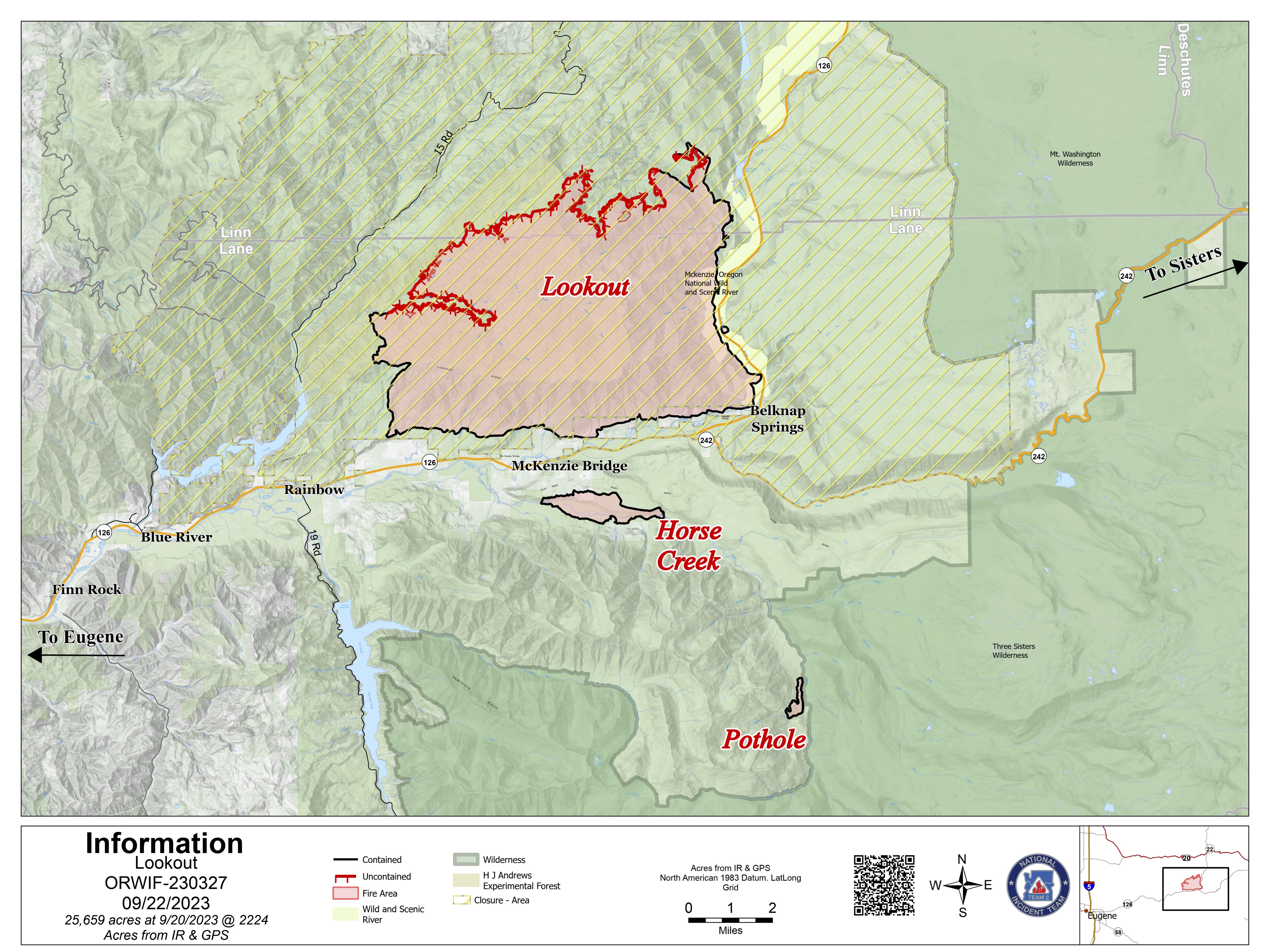
Lookout Fire: Size: 25,659 acres l Start Date: August 5 l Cause: Lightning l Containment: 50%
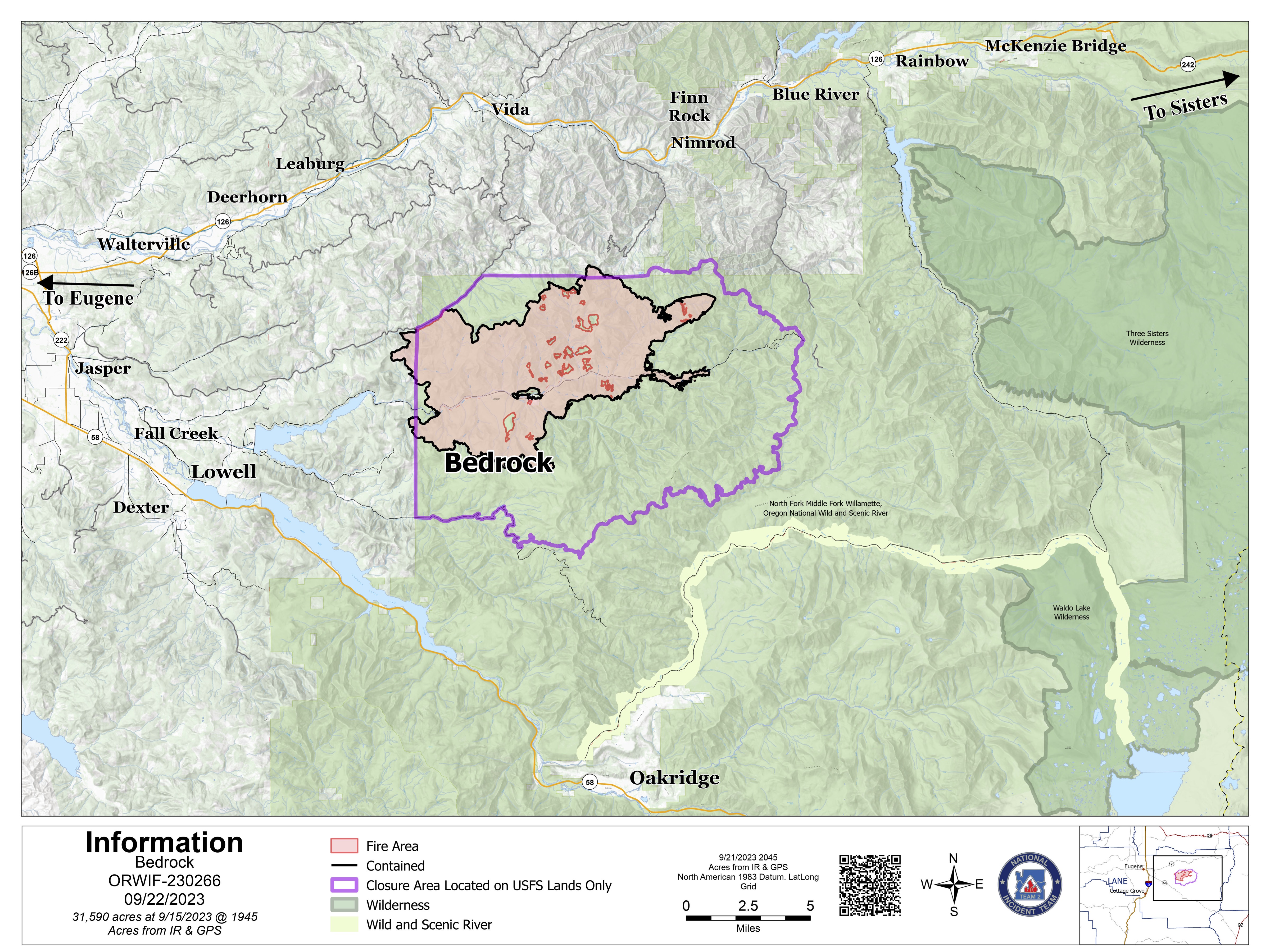
Bedrock Fire: Size: 31,590 acres l Start Date: July 22 l Cause: under investigation l Containment: 98%
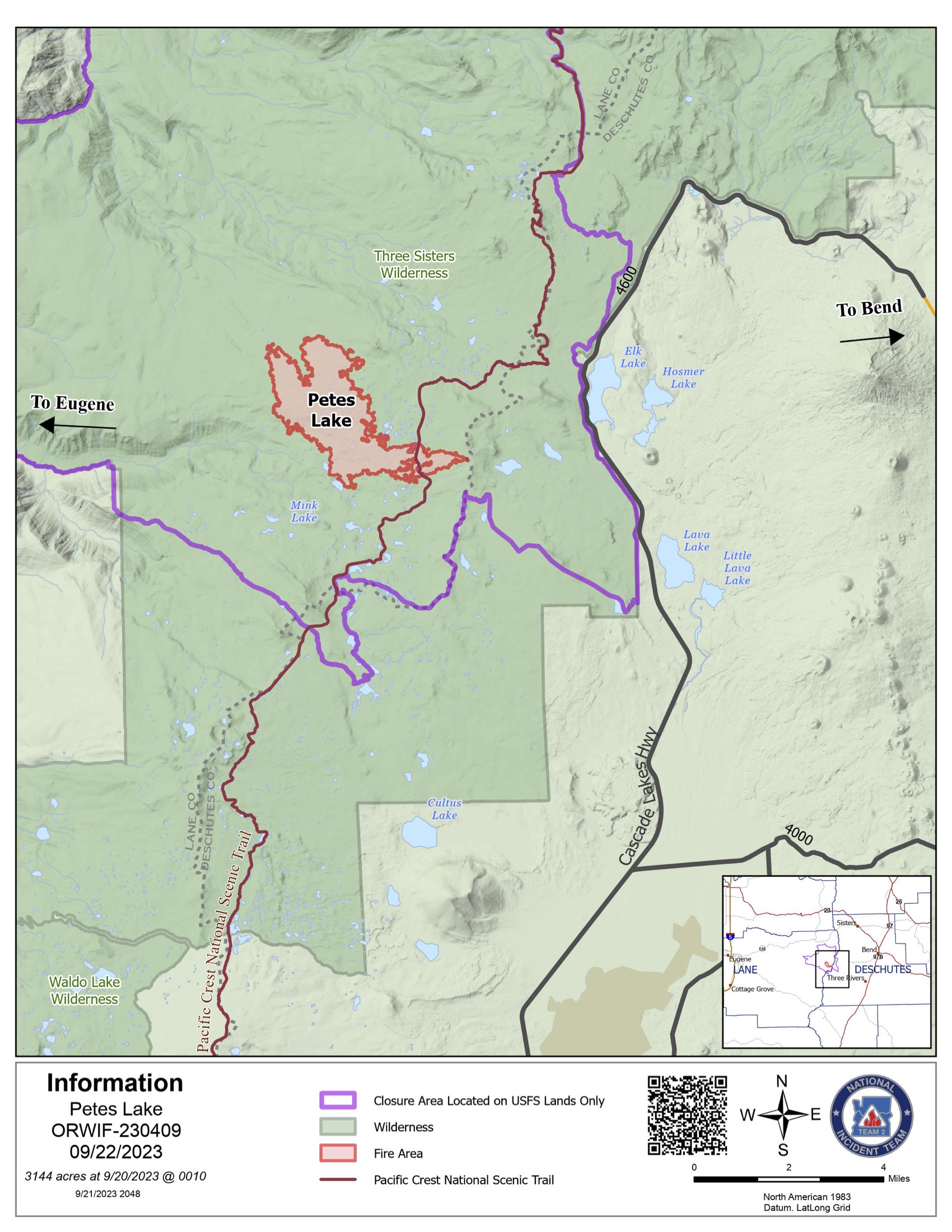
Petes Lake Fire: Size: 3,144 acres l Start Date: August 25 l Cause: Lightning l Completed: 50%
Horse Creek Fire: Size: 763 acres l Start Date: August 24 l Cause: Lightning l Containment: 100%
Pothole Fire: Size: 109 acres l Start Date: August 25 l Cause: Lightning l Containment: 100%
Total Personnel: 857
Total Assigned Resources: 29 engines l 19 crews l 7 dozers l 28 water tenders l 5 masticators l 8 helicopters
Suppression: Due to the moderate weather and minimal fire movement, indirect suppression activities have been reduced on the Lookout Fire and Petes Lake Fire. In the northern area of the Lookout Fire, a tub grinder has been deployed. This specialized equipment processes woody debris, turning it into mulch to reduce the orientation of fuel and, therefore fire behavior potential. Meanwhile, hotshot crews will hike into the Petes Lake Fire to monitor the fire’s behavior from the ground. To mitigate future fire risks, crews will continue fuels reduction activities, involving thinning and chipping around day use areas at Elk Lake and Quinn Meadow Horse Camp. Additionally, efforts continue along the Crescent Lakes Highway and Forest Road 4628, near the Deschutes Bridge and Cascade Lakes Highway junction. This work is focused on mastication and chipping to reduce fuels and enhance safety. Containment lines on Horse Creek Fire and Pothole Fire are being monitored to ensure the fire remains within its established footprint.
Suppression Repair: With the low fire activity across all fires, suppression repair efforts remain the main component of our operations, addressing the environmental impact caused during initial suppression activities. The Bedrock Fire included 21.2 miles of National Forest System trails, campgrounds, and day use areas along Fall Creek. Crews are working through repair suggestions provided by Resource Advisors on the northern end of the Bedrock Fire and southern areas of the Lookout Fire. Some key aspects include identifying and removing fire weakened trees along roadways, clearing woody debris from the forest floor to assist in ecological recovery, backhauling hose lay and equipment, stabilize soils on dozer and hand lines to prevent soil erosion, and ensuring the ditches and culverts are clear for the upcoming rain. Repair work is essential for the safety of forest users, prevents roads from washing out, reduces fuel loading for the future, and protects stream health and will continue long into the future.
Burned Area Emergency Rehabilitation (BAER): The BAER team released an assessment of the Bedrock Fire yesterday afternoon, which outlined both short-term and long-term recovery concerns. The soil-burn severity map for the Bedrock Fire identifies 10.8 percent of the fire area as having high burn severity and 28.5 percent with moderate burn severity. The remaining 60.7 percent has low or very low burn severity. By using the burn severity map, BAER scientists calculate expected increases in stream flows and run models to identify areas prone to erosion or landslides, these findings provide information needed to prepare and protect against post-fire threats identifying areas for immediate repair within 1 year of fire containment.
Weather: Clear skies and light winds throughout the night brought the temperatures down to the middle 30s and low 40s. There will be a brief transition to warm and dry weather for today, with the max temperature in the middle 70s. However, there is a strong storm system with wetting rain expected towards the end of the weekend and into the beginning of next week.
Linn County Evacuations: Visit the Linn County Wildfire map for current evacuation information.
Lane County Evacuations: Visit the Lane County Lookout Fire Evacuation Areas map for current evacuation information.
Deschutes County Evacuations: Visit the Deschutes County Emergency Information map for current evacuations information.
Forest Closures: Emergency closure orders remain in place for the Willamette National Forest and the Deschutes National Forest. For information on Oregon hunting regulations and these forest closures, contact Oregon Department of Fish and Wildlife at (503) 947-6000.
Restrictions: Fire Restrictions are in place on the Willamette National Forest and Deschutes National Forest. Temporary Flight Restrictions remain in place over the Bedrock and Lookout Fire areas.
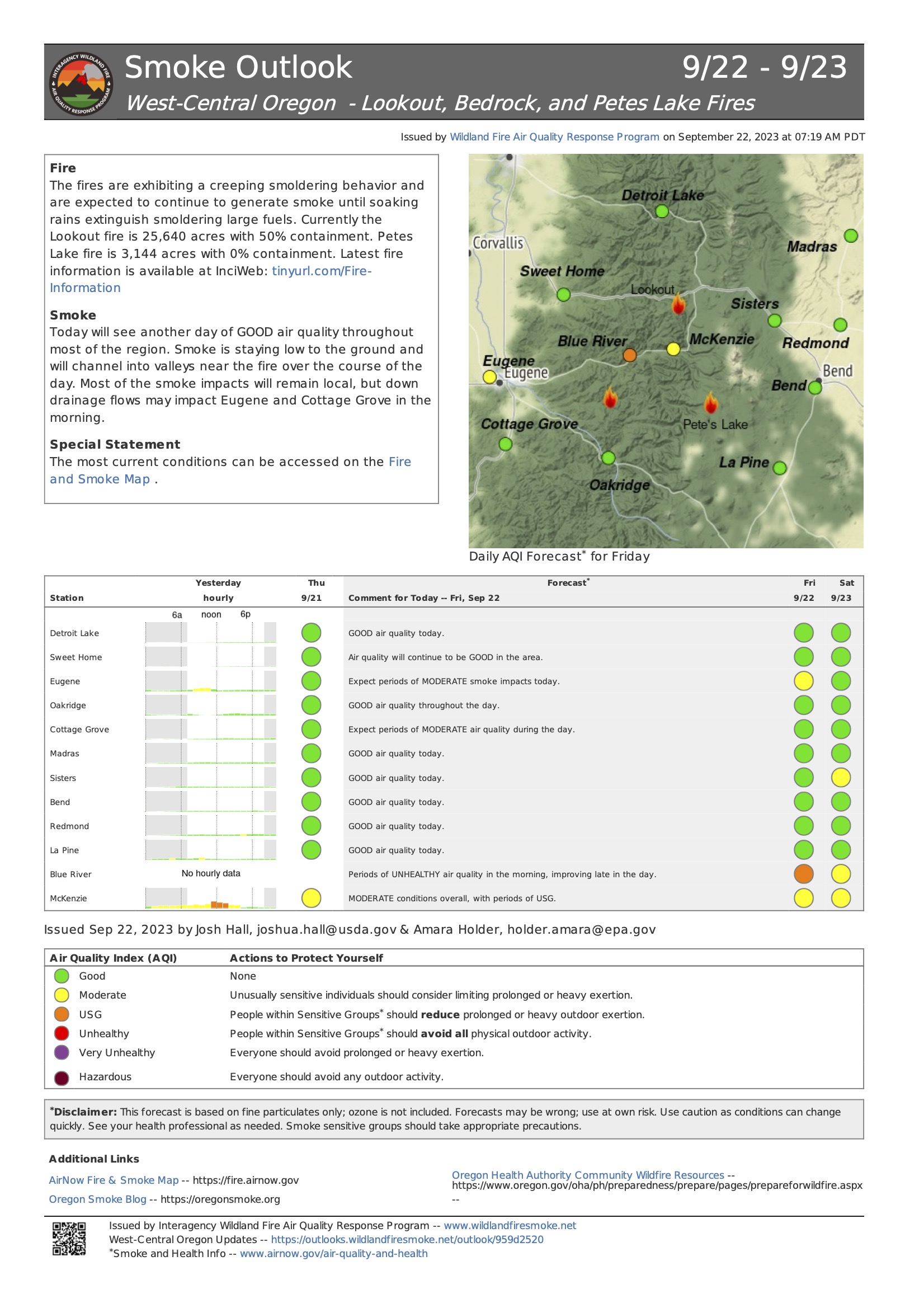
Smoke Outlook: A smoke outlook for West-Central Oregon includes the Lookout, Bedrock, Petes Lake, Horse Creek, and Pothole Fires. Another source for air quality information is the Fire and Smoke map from airnow.gov.
Fire Information:
Email: 2023.lookout@firenet.gov
Phone: 541-215-6735 (8 a.m. - 8 p.m.)
Facebook:
InciWeb:
South Fork Complex Update September 22 2023
Related Incident: South Fork Complex
Publication Type: News
South Fork Complex Update
Friday, September 22, 2023
Fire Information: 208-510-7856, 8 a.m. to 8 p.m.
Email: 2023.southforkcomplex@firenet.gov
Linktree: https://linktr.ee/2023southforkcomplex
3-9 Fire: 2,840 acres with 85% containment
Pellitreau Fire: 3 acres with 100% containment
Pilot Fire: 1,055 acres with 100% containment
Sulphur Fire: 31 acres with 100% containment
3,929 acres and 90% overall containment for the South Fork Complex
A total of 192 personnel, crews, air support, engines, dozers, and water tenders support the incident.
3-9 Fire – Crews are actively engaged in repair activities falling snags and trees to reduce fuel loads by removing hazardous trees. Engines are monitoring the interior smoke and heat. Heavy equipment operators continue repairing roads and installing water bars while the United States Forest Service Resource Advisors (READs) follow behind addressing any potential concerns with tribal, cultural, and natural resources in the area. Excavators continue preparation work for the chipping operation.
The Pilot Fire is 100% contained. Crews continue to patrol the fire perimeter while actively engaged in suppression repair and are scouting out potential roads in need of rehab.
The Pellitreau Fire and the Sulfur Fire are 100% contained. Firefighters continue to patrol the fires periodically to ensure fire remains within containment lines.
Weather: Dry and sunny weather is expected Friday. Afternoon highs remain in the lower 60s to lower 70s, with humidity levels trending a little higher, 25-35%. Winds will be light downslope in the morning, becoming west northwest 5 to 10 miles per hour (mph) gusting to 17 mph in the afternoon.
Forest Closure: Forest Closure orders for the South Fork Complex Fire continue to be in effect and are posted on the Shasta-Trinity National Forest and the Six Rivers National Forest websites. Please avoid closed areas.