
Cowlitz Complex Daily Update for September 20 2023
Related Incident: Cowlitz Complex
Publication Type: News
Facebook: https://www.facebook.com/cowlitzcomplex/ Twitter: https://twitter.com/GPNF
Gifford Pinchot National Forest: https://www.fs.usda.gov/giffordpinchot
Incident Photos and Videos for download for public and media use: https://www.dropbox.com/scl/fo/kczcrxz6g5rfbtv7znub7/h?rlkey=794wim8o7dwdzpyauajqilcvn&dl=0
Cowlitz Complex Fire Update
September 20, 2023
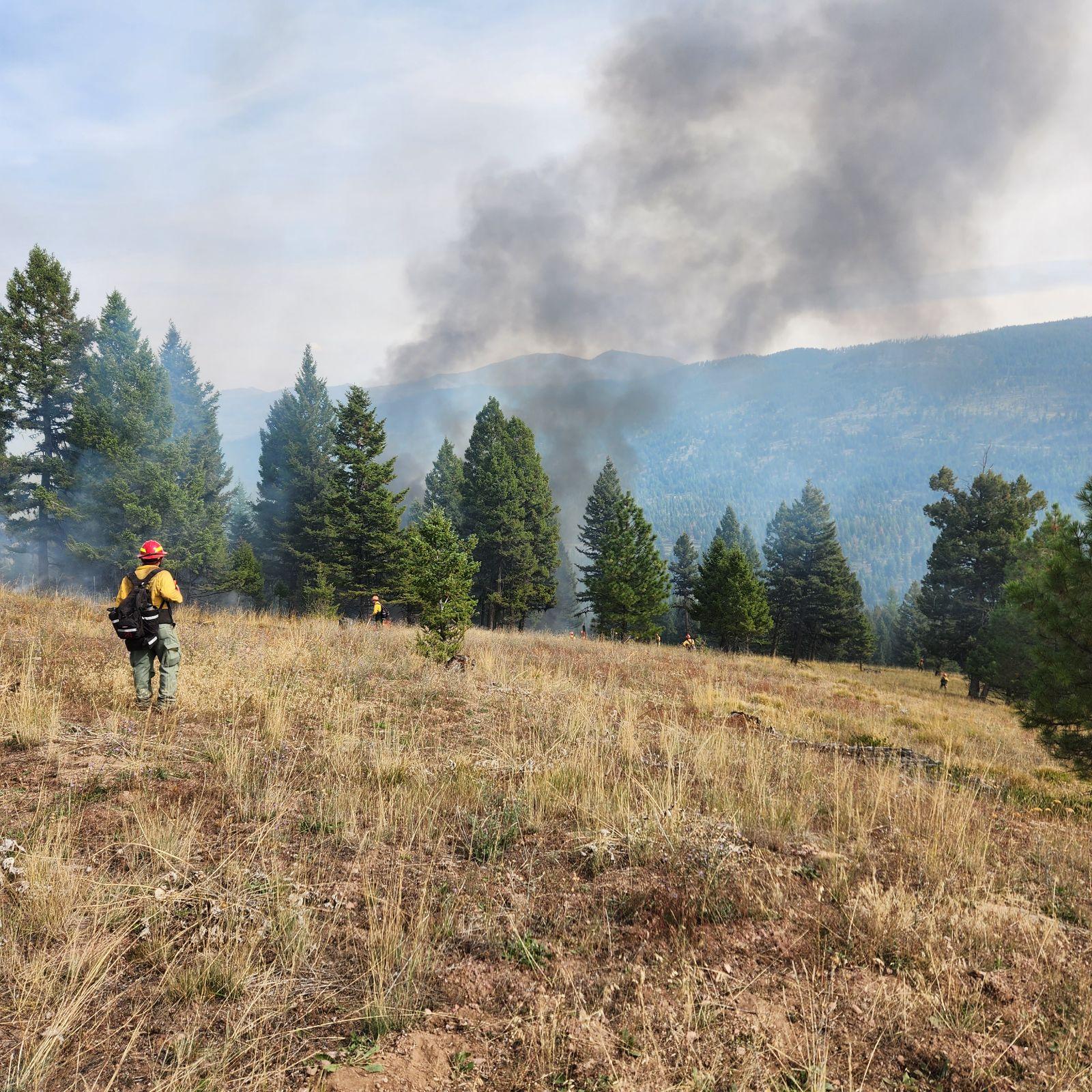
Current Situation: The Cowlitz Complex is 34% contained with a total of 715 acres and 303 personnel. The fire has slowed enough that fire managers have been able to release two helicopters to other fires with more immediate needs, leaving five available for the Cowlitz Complex. The fire continues to smolder and creep within the forest duff layer (needles, twigs, shedded bark) and the root systems of trees. Crews continue to work on constructing additional “contingency” lines which act as an additional line of defense in the unlikely event the fire grow beyond existing perimeters. Fire managers do not anticipate much movement on the fires as temperatures cool.
Safety Message: Wet weather and rain bring more hazards on the roadways. Slower travel speeds are required to remain safe, especially on dirt or gravel roads. Leave extra distance between vehicles when visibility decreases. Be sure your tires are roadworthy and your windshield wipers are working.
Background: There are 30 fires in the complex. The fires started August 25 after a lightning event across the Gifford Pinchot National Forest. All fires are being managed under full suppression strategy.
Fire Restrictions: Fire Restrictions remain in effect. Campfires are prohibited across the Gifford Pinchot National Forest – only propane-fueled fire pits, stoves and lanterns are allowed. Additional information is available on the forest’s website at Gifford Pinchot National Forest - Fire Management (usda.gov). The decision to lift or maintain fire restrictions depends on factors such as current and expected weather conditions, fuel moisture, the level of fire activity, and the availability of firefighting resources to respond to additional ignitions.
Closures: In anticipation of ongoing fire activity in the vicinity of the Snagtooth Fire the following roads and trails are closed to the public to reduce exposure and help ensure public and firefighter safety: Forest Roads 9300 and 9341, Boundary Trail #1 (from Elk Pass to intersection with Summit Prairie), Summit Prairie #2, Craggy Peak #3, Snagtooth #4, Quartz #5, Stabler Camp #17, Wright Meadows #80, Basin Camp #3A, Quartz #5B, Quartz #5C (French Creek), Snyder Pasture #80A. Forest Road 8410 is closed for firefighter and public safety in the vicinity of the Pothole Fire, and Forest Road 78 is temporarily closed between the 78 and the 22 junction due to hazardous debris rolling out onto the roadway.
Temporary Flight Restrictions: Two TFRs are in effect during daylight hours, one located north of US-12 to Mount Rainier National Park, and a new TFR south of US-12 to include Snagtooth and Spencer Quartz fires. Fire aviation response is halted or delayed if an unauthorized aircraft enters the TFR. Temporary flight restrictions also apply to unmanned aircraft systems or drones. Learn more: Know Before You Fly.
September 20 2023 Prescribed Fire Update
Related Incident: Lolo National Forest Prescribed Fire Operations
Publication Type: Announcement
Superior Ranger District:
Pending conditions, prescribed fire operations will take place today on the Superior Ranger District to reduce hazardous fuels from previous vegetation management operations.
Firefighters will conduct up to 25 acres of prescribed burning on two units today. The two units are located 5 miles northeast of Superior near Johnson Creek and 6 miles northeast of Henderson near Breen Creek.
Some residual smoke may be visible from St. Regis, Henderson, and Superior. Fire personnel will implement the prescribed burn, patrol, and monitor the burning over the next few days.
Wednesday September 20 2023 Valentine Fire Update and Maps
Related Incident:
Publication Type: News
Size: 5,300 acres
Start Date: August 16, 2023
Cause: Lightning
Completion: 66%
Total personnel: 173
Location: 11 miles northeast of Young, Arizona and 27 miles
east of Payson, Arizona
Fuels:Ponderosa Pine, Hardwood litterand timber
Highlights: The warmer weather allowed fuels to dry out and allow crews to continue making progress along the southern and western borders.
Operations: Yesterday, conditions allowed crews to continue hand and aerial ignitions on the south perimeter along FSRD 411 moving towards FSRD 200. Tactical firing operations continued down Chamberlain Trail (FSRD 200) on the west perimeter towards the FSRD 848, making good progress. Today, crews will continue with hand and aerial ignitions on the west side along the Chamberlin Trail Road (FSRD 200). Crews will continue monitoring the fire within the interior along the ridgelines and drainages.
Fire Ecology: A unique species growing in the vicinity of the Valentine fire is Chihuahuan pine. Chihuahuan pine has many fire adaptations and fire-associated regeneration strategies. After a fire, it regenerates by producing abundant seeds that are dropped from serotinous cones to the newly burned forest floor. It’s protected from fire by thick bark and, even when the crowns burn, it has the ability to send out new shoots to regrow. Fire may even allow Chihuahuan pine to become more dominant by eliminating less fire tolerant species.
Weather: On Tuesday, temperatures were in the mid 70’s with winds out of the southwest. Wednesday’s forecast calls for temperatures hovering around 75 degrees with variable winds out of the southwest.
Closures: An emergency closure order for the Valentine Fire has gone into effect as of 6 a.m. Sept. 5, 2023. The public is asked to avoid the fire area. The purpose of the closure order is to protect public health and safety during the Valentine Fire and to protect assigned firefighting personnel engaging in wildland firefighting operations. Signs and gates will be in place to remind the public not to enter the fire area. Please visit the Alerts and Notices page for more information. https://www.fs.usda.gov/alerts/tonto/alerts-notices.
Safety: The health and safety of firefighters and the public are always the highest priority. Members of the public are asked to avoid the fire area.
Smoke: The fire may produce additional smoke due to tactical firing operations. Smoke from the Valentine Fire may be visible in the surrounding areas for multiple days. Smoke-sensitive individuals and people with respiratory problems or heart disease are encouraged to take precautionary measures. An interactive smoke map at https://www.airnow.gov/wildfires/ lets you zoom into your area to see the latest smoke conditions.
Information Links and Contacts
Tonto National Forest: https://www.fs.usda.gov/main/tonto/fire
InciWeb: https://inciweb.nwcg.gov/incident-information/aztnf-valentine-fire
Fire Email: 2023.valentine@firenet.gov
Fire Information Line: (928)-421-4579 • Office Hours: 8:00 AM – 8:00 PM
PostFire Hydrology
Related Incident: 2023 Sourdough Fire Burned Area Emergency Response (BAER)
Publication Type: News
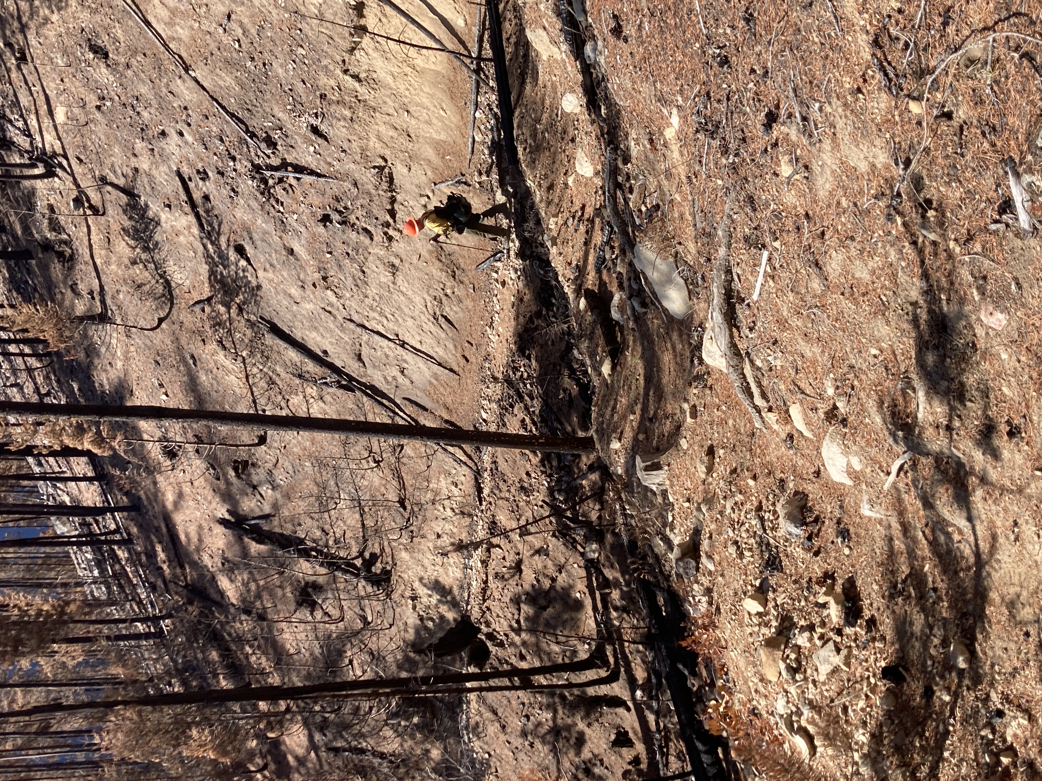
The Sourdough Fire is burning on the western slope of the North Cascades mountains, which is known for high levels of annual rainfall, dense evergreen forests, high biodiversity, and rugged backcountry. Visitors will see old-growth trees like western hemlock and red cedar, which create a multi-layered canopy that intercepts water during heavy rain events. The tiny, needle-like leaves of these lush trees create thick layers of organic material, or duff, that cover the soil below them as they drop from their branches. Other trees, like bigleaf maple, grow deep and expansive root systems that stabilize the soil by physically holding it in place.
When a wildfire burns through areas of dense vegetation like these, it removes stabilizing elements in the landscape and the effects of a storm become much different than what was present before. More water hits the ground at once, too fast for the soil to absorb it, which can cause flooding. This is exacerbated by a reduction of the duff layer, which act as a sponge to hold some of the rainwater. With higher water flow and fewer root systems to stabilize the soil, mudslides and debris flow become more likely as rain dislodges soil. Flooding, mudslides, and debris flows pose a threat to visitors, residents, and employees in the Sourdough Fire area. Flooding can damage structures and carry away vehicles, but soil and debris exacerbate the risk. As soil and debris become mobilized, they carry more weight and strength than water alone. Debris like large logs, boulders, and fencing can be carried by water along a drainage. The Stetattle Creek drainage, where the Sourdough Fire is burning, has a high concentration of large boulders that are over two feet wide. These heavy elements can strike people during a flood event, trap vehicles, and destroy structures in their path.
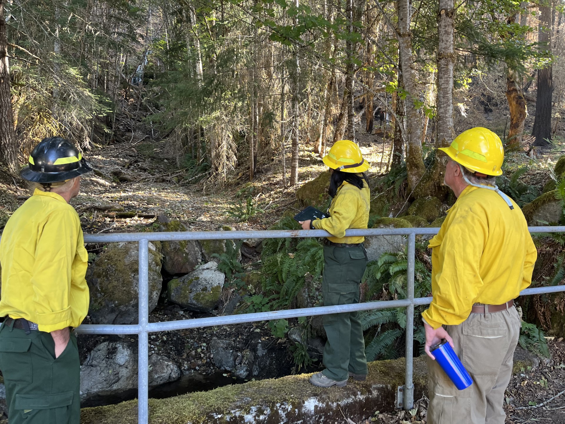
The Sourdough Burned Area Emergency Response (BAER) team was deployed to evaluate and address threats to human life and safety, many of which stem from flooding risks. Hydrologists started the assignment by collecting data from satellite images, called Burned Area Reflectance Classification (BARC). BARC provides data about how severe the soil burns in a wildfire and separates them into four classes: high, moderate, low, and unburned. Hydrologists used BARC imagery to create a first draft of a soil burn severity map, which they then improved using field data.
Hydrologists hiked into the burn area to ground truth the estimates provided by satellite imagery. They took measurements to understand how deeply the soil was charred, the condition of the plant root systems, the impact to the duff layer above the soil, and the pre- and post-fire behavior of the soil. Hydrologists conducted water repellency tests, which measure the rate at which water penetrates and is absorbed into the soil, in unburnt and burnt areas. Soils were water-repellant in both types of areas, causing hydrologists to speculate that the water repellency was likely due to recent dry weather and not the Sourdough Fire.
Back at the office, hydrologists plugged the field data into models. They modeled future runoff and debris flows by simulating different levels of storms and predicting changes in peak flows, runoff volume, erosion, and sediment movement. This data enables land managers in the Sourdough Fire area to predict and assess potential hazards so that they can plan mitigations in at-risk areas.
The BAER team is here to support safe and effective post-fire management so that residents, employees, and visitors remain safe in a post-fire-changed landscape. These risks will likely last for years after the fire is contained. As vegetation grows back in the area and as infrastructure like trails are rehabilitated, the public should expect that recreation in the area may be limited for some time.
BAER Tales Botanist Provide Roots on the Sourdough BAER Team
Related Incident: 2023 Sourdough Fire Burned Area Emergency Response (BAER)
Publication Type: News
Janet is a Supervisory Botanist, but she identifies as a vegetation ecologist. While true botanists focus their work on individual species; her interest lies in how species interact with the landscape and how communities of plants respond to environmental stressors.
Janet manages and coordinates the vegetation programs at Olympic National Park including rare plant inventory and management, invasive plant management, native vegetation restoration, vegetation research, and the hazard tree program. Most of her day job is administrative, so she relishes the opportunity to work in the field with a Burned Area Emergency Response (BAER) team.
Janet has a strong interest in the ecological role of fire and has been serving on wildfire assignments since 2009. During her first permanent job in the National Park Service (NPS), she worked at a park that had experienced major fire events. She observed both benefits to the ecosystem, like clearing out thickets of young white fir, and harms, like non-native plant invasions. Her experience and interest made her an excellent fit for her first BAER assignment as the lead botanist for the Reading Fire at Lassen Volcanic NP.
On the Sourdough BAER, Janet has been putting together a puzzle of plant behavior and biology against a background of wildfire disturbance. In the field, Janet surveyed invasive plant populations in unburned areas that were immediately adjacent to burned ones in the Complex. These weeds, like Scotch broom and bull thistle, are the potential seed sources for future invaders of burned ground. Back in the office, she researched Complex policies related to invasive plant management, spoke with local experts, and analyzed existing invasive plant data to learn what non-native species are most likely to show up in the Sourdough Fire footprint.
Non-native invasive plants are a major concern after the Sourdough Fire. Invasives establish themselves in recently disturbed, open spaces, which can slow the recovery of native species including the forest canopy. The first year after a fire is critical to ensure that the desired recovery occurs over the 3-4 years a BAER project is funded. Managers at the North Cascades National Park Service Complex will collaborate with other agencies and organizations to implement the treatments as designed in the BAER process.
Wildfire has a big impact on vegetation since plants compose most fire fuels. The issues Janet focuses on are those in which fire suppression activities impact rare plants, intersect with invasive plants, or when trees damaged by fire create hazards for humans or infrastructure. BAER, and its extension Burned Area Rehabilitation (BAR), provide an opportunity to ensure that native plants have a strong start and successfully revegetate burned areas, without letting invasive non-native plants take over.
In the case of the Sourdough Fire, most plants will enter winter dormancy very soon. As spring plants start to emerge in the burn scar, restoration crews funded through BAER and BAR will survey the area and implement recommended treatments for mitigating invasive nonnative plant populations.
Janet compares visiting a recently burned area to visiting a loved one who is in the hospital with a severe illness. The burned area is in a very delicate state and its recovery can be set back by an unknowing visitor. She hopes that visitors to recently burned areas are careful not to bring weed seeds into a burned area on their boots, clothes, or packs.
Olympic National Park Fire Update September 19
Related Incident: 2023 Olympic National Park Lightning Fires
Publication Type: News
Port Angeles, Wash. – There was minimal fire activity across the park due to clouds, low temperatures, and rain. Fire acreages did not change. Firefighters are protecting infrastructure of value by setting up sprinklers and creating a defensible space in certain areas. Fire crews continue to leverage natural barriers - including mountain ranges, high alpine zones, and rivers - to confine the fires. Crews are using Promise Creek and the North Fork of the Quinault River to limit the Low Divide fire’s spread to the south.
A localized smoke forecast was created for communities surrounding Olympic National Park: Current Smoke Outlook for Olympic NP (airfire.org)
Fire Name
Initial Report
Estimated Size as of 9/5
Location
Hurricane
8/28/23
4 acres
2,000 ft below Hurricane Ridge parking area
Eagle Point
8/28/23
123 acres
~5 miles out Obstruction Point Road
Diamond Mountain
9/1/23
30 acres
3.3 miles NE of
Anderson Pass
Low Divide
9/1/23
312 acres
N. Fork Quinault drainage
Delabarre
9/1/23
3,554 acres
3 miles SE of Mount Christie
Martins Lake
9/2/23
108 acres
2 miles NE of Mount Christie
Mount Queets
9/14/23
4 acre
Summit of Mount Queets
Fire is an integral part of the forested ecosystems on the Olympic Peninsula; plants and animals here have evolved with fire for thousands of years. By allowing fires to burn when appropriate, it allows the natural process to continue to occur and it lowers the fire danger in the future. Naturally occurring fires allow forests to be thinned, opening the canopy and allowing sunlight through. Fire also allows for the recycling of nutrients to the soil while reducing the amount of dead, woody debris. This allows for the sprouting and regrowth of plants, shrubs and trees.
Background Information
All seven active fires in Olympic National Park ignited when a series of lightning strikes occurred on the Olympic Peninsula in the afternoon on August 28.
Closures
Due to wildfire activity the following closures are in effect until further notice:
- Elwha River Trail from Whiskey Bend Trailhead to Low Divide
- Bailey Range Traverse beyond Cat Basin
- Long Ridge Trail to Dodger Point
- Hayden Pass Trail
- Dosewallips River Trail from Dose Meadows to Hayden Pass
- Dodger Point Way Trail
- North Fork Quinault Trail from Elip Creek trail junction to Low Divide
- Skyline Trail from Elip Creek Trail junction to Low Divide
- Martin Park Trail
- Obstruction Point Road and Trailhead
Olympic National Park Wilderness Information Center (WIC) will be notifying backcountry permit holders who may be impacted by these closures. Any permit holders who plan to backpack in the above impacted areas should contact the WIC at 360-565-2992 or by emailing OLYM_WIC@nps.gov.
Weather and Fire Behavior
Clouds will increase Tuesday afternoon with light rain increasing late afternoon into the evening (4PM-9PM), and a few rain showers overnight. Chance of rain remains lower during this period, around 30% Tuesday evening. Showers may linger into Wednesday before conditions dry out through Friday as upper-level ridging rebuilds. Then, the pattern looks to amplify towards the weekend and beginning of next week as a robust disturbance enters.
Information for the Olympic National Park Lightning Fires can be found at: 2023 Olympic National Park Lightning Fires Information | InciWeb (wildfire.gov)
Olympic Peninsula Smoke Forecast: Current Smoke Outlook for Olympic NP (airfire.org)
Olympic National Park information: www.nps.gov/olym
Olympic National Forest information: www.fs.usda.gov/olympic
State and county area burn bans: https://ecology.wa.gov/Air-Climate/Air-quality/Smoke-fire/Burn-bans
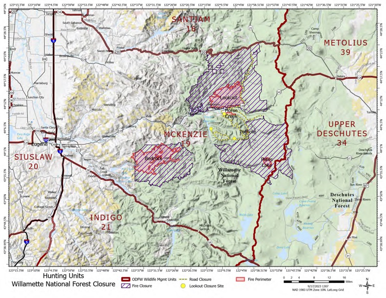
Hunting Units Closure Willamette National Forest
Related Incident: Petes Lake Fire
Publication Type: Announcement
It’s hunting season in Oregon, and it’s also still fire season as well. There are closures in place on the Willamette National Forest that primarily impact the McKenzie Unit (19) and a small area on the Upper Deschutes Unit (34). These closures are in place for both the public and firefighter safety. There’s plenty of emergency vehicles and logging equipment on forest roads.
Before you go hunting this season, be sure to check out the Willamette NF webpage for current closure information. Keep in mind, closures can change depending on fire activity. Also contact Oregon Department of Fish and Wildlife for hunting regulations (503) 947-6000 and toll free at (800) 720-6339, or visit their webpage at https://myodfw.com/
Temporary Public Use Restrictions DESCHUTES NATIONAL FOREST
Related Incident: Petes Lake Fire
Publication Type: Announcement
ORDER NO. 06-01-23-02
TEMPORARY PUBLIC USE RESTRICTIONS DESCHUTES NATIONAL FOREST
Pursuant to 16 U.S.C. § 551 and 36 CFR 261.50 (a) and (b), the following prohibitions apply to al lands within the Deschutes National Forest. This Order becomes effective on August 12th, 2023, and will remain in effect until November 30th, 2023, unless rescinded sooner.
This order supersedes and rescinds order #06-01-23-01 signed by Forest Supervisor HollyJewkes on July 13, 2023.
CLOSURE AREA DESCRIPTION:
These prohibitions apply to all lands within the Deschutes National Forest including the Three Sisters, Mt. Jefferson, M.t Thielson, Mt. Washington, and Diamond Peak Wilderness areas.
PROHIBITIONS:
Building, maintaining, attending, or using a fire, campfire, stove fire, including a charcoal fire, 36 CFR §261.52(a).
Smoking, except within an enclosed vehicle or building, a designated campground, or while stopped in an area at least three feet in diameter that is barren or cleared of all flammable material. 36 CFR § 261.52(d).
Possessing, discharging, using any kind of firework, or other pyrotechnic device. 36 CFR § 261.52(f).
Using an explosive. 36 CFR § 261.52(b).
Operating a chainsaw or other equipment powered by an internal combustion engine in violation of Industrial Fire Precaution directives (IFPL). 36 CFR § 261.52(h).
Operating or using anyinternal or external combustion engine without a spark arresting device properly installed, maintained and in effective working order meeting either:
. U.S. Department of Agriculture, Forest Service Standard 5100-1a; or
. Appropriate Society of Automotive Engineers (SAE recommended practice 1335(b) and
. J350(a). 36 CFR § 261.52(j)
Welding, or operating an acetylene or other torch with open flame. 36 CFR § 261.52(i).
Violating any state law concerning burning, fires, or which is for the purpose of preventing or restricting the spread of fire. 36 CFR § 261.52(k).
EXEMPTIONS:
Pursuant to 36CFR § 261.50(e), the following are exempt from this order:
.1 Persons with Forest Service Permit No. FS-7700-48 (Permit for Use ofRoads, Trails, or Areas
Restricted by Regulation Order), specifically exempting them from this Order.
2. Any Federal, State or Local Officer or member of an organized firefighting force in the
pertormance of an otticial duty.
3. Petroleum-fueled stoves, lanterns or heating devices, provided such devices meet the tire
underwriters specitications for safety.
4. Campfires contained inside established fire rings within campgrounds listed on Exhibit A.
These prohibitionsa r e inaddition to the general prohibitions in 36 CFR. Part 261, Subpart A.
Violations of this prohibition are punishable by a fine of not more than $5,000 for an individual or
$10,000 for an organization, or imprisonment for not more than 6 months, or both (16 U.S.C. 3 551; 18
U.S.C. 553551, 3559, 3571, and 3581.
Done taBend, Oregon, on August10,, at8:00AND/ PM.
Loll
HOLLY JEWKES
Forest Supervisor
Deschutes National Forest
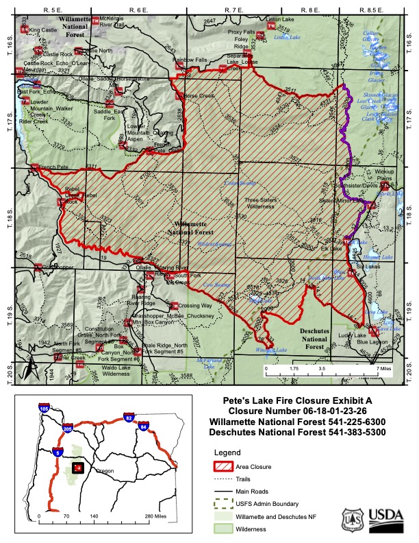
PETES LAKE FIRE EMERGENCY AREA CLOSURE
Related Incident: Petes Lake Fire
Publication Type: Announcement
DESCHUTES NATIONAL FOREST BEND, OREGON
ORDER # 06-18-01-23-26
FOREST ORDER
PETES LAKE FIRE EMERGENCY AREA CLOSURE
Pursuant to 16 U.S.C. § 551 and 36 CFR § 261.50 (a) and (b), and to provide for public safety, the following acts are prohibited on the National Forest System (“NFS”) areas, roads, and trails described below within the administrative boundaries of the Willamette and Deschutes National Forests. This Order is effective on August 27, 2023, through September 27, 2023, unless otherwise rescinded sooner.
PROHIBITIONS:
1. Being on the road. 36 CFR § 261.54(e)
2. Being on a trail 36 CFR § 261.55(a)
3. Entering into or being upon National Forest System Lands closed for the protection of public health and safety. 36 CFR § 261.53(e)
CLOSURE AREA:
The closure area is located within the State of Oregon, Lane and Deschutes Counties, and within the administrative boundaries of the Willamette National Forest and Deschutes National Forest. The closure applies to the NFS areas, roads, and trails and trailheads described below. The closure area is depicted on the attached map, which is incorporated into this order as “Exhibit A”. All areas, roads, trails, campgrounds, and rec sites in this closure area are closed. Recreation sites, trails and campgrounds closed by this order are depicted in “Exhibit B”.
Area Closure Description
The closure boundary starts at the junction of the Elk Creek Trail (#3510) and the Three Sisters Wilderness boundary in Township 19 S, Range 6 E, Section 3. The closure boundary follows the Three Sisters Wilderness boundary north and then west to the French Pete Trailhead. The closure boundary follows the French Pete Trail (#3511) east to the Pat Saddle Trailhead, where it then continues along the Three Sisters Wilderness boundary east and north to the Foley Ridge Trailhead. The closure boundary follows and includes the Foley Ridge Trail #3511 east, until the junction with the Pacific Crest Trail (#2000). The boundary follows, but does not include, the PCT south to the junction with Mirror Lakes Trail (#20), and at which point it follows, but does not include, Trail #20 southeast to the junction with Trail 12. The closure continues south following but not including Trail 12, until the junction with Trail 2, and follows but does not include Trail 2 to the Three Sisters Wilderness Boundary. The closure boundary follows the Three Sisters Wilderness boundary south to the intersection with Metolius-Windigo Trail (#99), where it follows, but does not include, Trail 99 to the junction with Trail 14.1. The closure boundary follows and includes Trail 14.1 to Trail 14, and continues west to the Willamette- Deschutes National Forest Boundary. The closure follows the forest boundary south and west, until it crosses the Pacific Crest Trail in Township 19 South, Range 7 E, Section 20. The closure boundary continues south, following and including the PCT until the Snowshoe Lake Trail (#33). The closure follows and includes Trail 33 to the junction with Trail 16, goes west and north, following and including Trail 16, which becomes Trail 3510, to the starting point.
EXEMPTIONS:
Pursuant to 36 CFR § 261.50(e)(1) and (4), the following persons are exempt from this Order:
(1) Persons with Forest Service Permit No. FS-7700-48 (Permit for Use of Roads, Trails, or Areas Restricted by Regulation or Order) specifically exempting them for this Order.
(2) Any Federal, State, or Local Officer, or member of organized rescue or fire fighting force in the performance of an official duty.
These prohibitions are in addition to the general prohibitions in 36 CFR Part 261, Subpart A.
Violations of these prohibitions are punishable by a fine of not more than $5,000.00 for an individual or $10,000.00 for a corporation or imprisonment for not more than six months or both. 16 U.S.C. § 551 and 18 U.S.C. § 3551, 3571, and 3581.
Executed in Springfield, Oregon on this 27 day of August 2023.
David Warnack
Forest Supervisor Willamette National Forest
Holly Jewkes
Forest Supervisor Deschutes National Forest
ORDER #06-18-01-23-26
BLM Fire Closure Area Expanded September 19
Related Incident: Anvil Fire
Publication Type: Announcement
Bureau of Land Management (BLM) Coos Bay District has expanded its closure of BLM-managed lands near the Anvil Fire to: ensure firefighter and public safety; promote resource integrity; and allow for unimpeded fire suppression and burned area site recovery efforts. See the attached closure order and map for complete details.