
South Fork Complex Update September 19 2023
Related Incident: South Fork Complex
Publication Type: News
South Fork Complex Update
Tuesday, September 19, 2023
Fire Information: 208-510-7856, 8 a.m. to 8 p.m.
Email: 2023.southforkcomplex@firenet.gov
Linktree: https://linktr.ee/2023southforkcomplex
3-9 Fire: 2,840 acres with 85% containment Pellitreau Fire: 3 acres with 100% containment
Pilot Fire: 1,055 acres with 100% containment Sulphur Fire: 31 acres with 100% containment
3,929 acres and 90% overall containment for the South Fork Complex
A total of 201 personnel, crews, air support, engines, dozers, and water tenders support the incident.
3-9 Fire – Engines are monitoring the interior heat and patrolling containment lines. Crews are installing water bars along roadways determined by the United States Forest Service Resource Advisors (READs). Crews are also working closely with the READS to address concerns with tribal, cultural, and natural resources in the area.
The Pilot Fire is 100% contained. Crews will continue to patrol the fire perimeter while actively engaged in suppression repair.
The Pellitreau Fire and the Sulfur Fire are 100% contained. Firefighters continue to patrol the fires periodically to ensure fire remains within containment lines.
Weather: Dry weather is expected on Tuesday. Winds will be light southeasterly in the morning, becoming west northwest in the afternoon. Wind gusts are expected to be 10 to 15 miles per hour (mph) during the afternoon. A cooling trend continues, with afternoon highs in the upper 70s to around 80 with afternoon humidity dropping to around 35%.
Forest Closure: Forest Closure orders for the South Fork Complex Fire continue to be in effect and are posted on the Shasta-Trinity National Forest and the Six Rivers National Forest websites. Please avoid closed areas.
Actualizacin del Incendio del Complejo Cowlitz 19 de septiembre de 2023
Related Incident: Cowlitz Complex
Publication Type: News
Facebook: Facebook/CowlitzComplex Twitter: https://twitter.com/GPNF
Bosque Nacional Gifford Pinchot: https://www.fs.usda.gov/giffordpinchot
Actualización del Incendio del Complejo Cowlitz
19 de septiembre de 2023
Situación actual: El complejo Cowlitz está contenido en un 34%, con un total de 695 acres y 352 efectivos. El clima fresco y las precipitaciones ligeras provocaron un crecimiento escaso o nulo en el complejo. Las cuadrillas siguen reforzando las líneas de contención (líneas que no se espera que el fuego cruce) en la parte sur del Grassy Mountain Fire, donde se cruzará con un límite de carretera fortificada. El Snagtooth está manteniendo focos de calor dispersos, en parte debido a la profunda capa de mantillo forestal. El incendio de Spencer Quartz sigue ardiendo. Los trabajos en la línea de mano construida conectarán con una carretera reforzada para completar una barrera en el extremo sur del incendio.
Mensaje sobre seguridad: Hay muchos camiones y equipos de bomberos en las carreteras del Servicio Forestal en las proximidades de varios de los incendios dentro del Complejo Cowlitz. También es temporada de cacería. Hay 86 bomberos en el "campamento de spike o spike camp" fuera del sitio que viajan a los incendios del sur todos los días. Por favor, tenga cuidado en las carreteras a medida que viajan a través del bosque, sobre todo porque las carreteras se ponen resbaladizas con el tiempo húmedo.
Antecedentes: Hay 30 incendios en el complejo. Los incendios se iniciaron el 25 de agosto tras un rayo en el Bosque Nacional Gifford Pinchot. Todos los incendios se están gestionando con una estrategia de supresión total.
Restricciones contra incendios: Siguen vigentes las restricciones sobre incendios. Las hogueras están prohibidas en todo el Bosque Nacional de Gifford Pinchot; sólo se permiten las hogueras de propano, las estufas y las linternas. Encontrará más información en el sitio web del bosque en Gifford Pinchot National Forest - Fire Management (usda.gov). La decisión de levantar o mantener las restricciones contra incendios depende de factores como las condiciones meteorológicas actuales y previstas, la humedad del combustible, el nivel de actividad del incendio y la disponibilidad de recursos de extinción para responder a nuevas igniciones.
Cierres: En previsión de la actividad del fuego en curso en las proximidades del Snagtooth Fire las siguientes carreteras y senderos están cerrados al público para reducir la exposición y ayudar a garantizar la seguridad pública y de los bomberos: Carreteras forestales 9300 y 9341, Boundary Trail #1 (desde Elk Pass hasta la intersección con Summit Prairie), Summit Prairie #2, Craggy Peak #3, Snagtooth #4, Quartz #5, Stabler Camp #17, Wright Meadows #80, Basin Camp #3A, Quartz #5B, Quartz #5C (French Creek), Snyder Pasture #80A. La carretera forestal 8410 está cerrada para los bomberos y la seguridad pública en las inmediaciones del incendio de Pothole, y la carretera forestal 78 está cerrada temporalmente entre el cruce de la 78 y la 22 debido a los escombros peligrosos que ruedan por la calzada.
Restricciones Temporales de Vuelo: Hay dos TFR en vigor durante las horas diurnas, uno situado al norte de la US-12 hacia el Parque Nacional del Monte Rainier, y un nuevo TFR al sur de la US-12 para incluir los incendios de Snagtooth y Spencer Quartz. La respuesta de la aviación contra incendios se detiene o retrasa si una aeronave no autorizada entra en el TFR. Las restricciones temporales de vuelo también se aplican a los sistemas de aeronaves no tripuladas o drones. Más información: Know Before You Fly.
Anvil and Flat Fires Smoke Outlook September 1920
Related Incident: Anvil FireFlat Fire
Publication Type: News
Active burning on the Anvil fire continues, with the fire size over 9000 acres and zero containment. Much of the fire remains in a drier elevation above the moist marine layer. A weather change, with cooler conditions should reduce smoke for most of the areas north and east of the Anvil Fire this week.
Cowlitz Complex Daily Update for September 19 2023
Related Incident: Cowlitz Complex
Publication Type: News
Facebook: https://www.facebook.com/cowlitzcomplex/ Twitter: https://twitter.com/GPNF
Gifford Pinchot National Forest: https://www.fs.usda.gov/giffordpinchot
Incident Photos and Videos for download for public and media use: https://www.dropbox.com/scl/fo/kczcrxz6g5rfbtv7znub7/h?rlkey=794wim8o7dwdzpyauajqilcvn&dl=0
Cowlitz Complex Fire Update
September 19, 2023
Current Situation: The Cowlitz Complex is 34% contained with a total of 695 acres and 352 personnel. The cooling weather and light precipitation led to little or no growth on the complex. Crews are continuing to strengthen containment lines (lines that the fire is not expected to cross) in the southern part of the Grassy Mountain Fire where it will intersect a fortified road boundary. The Snagtooth is holding pockets of scattered heat, partly due to the deep forest duff layer. The Spencer Quartz Fire continues to smolder. Work on constructed hand line will connect to a reinforced road to complete a barrier at the southern end of the fire.
Safety Message: There are many trucks and fire equipment on the Forest Service roads in the vicinity of several of the fires within the Cowlitz Complex. It is also hunting season. There are 86 firefighters at the off-site “spike camp” who travel to the southern fires daily. Please use caution on the roads as you travel through the forest, especially as roads get slippery with wet weather.
Background: There are 30 fires in the complex. The fires started August 25 after a lightning event across the Gifford Pinchot National Forest. All fires are being managed under full suppression strategy.
Fire Restrictions: Fire Restrictions remain in effect. Campfires are prohibited across the Gifford Pinchot National Forest – only propane-fueled fire pits, stoves and lanterns are allowed. Additional information is available on the forest’s website at Gifford Pinchot National Forest - Fire Management (usda.gov). The decision to lift or maintain fire restrictions depends on factors such as current and expected weather conditions, fuel moisture, the level of fire activity, and the availability of firefighting resources to respond to additional ignitions.
Closures: In anticipation of ongoing fire activity in the vicinity of the Snagtooth Fire the following roads and trails are closed to the public to reduce exposure and help ensure public and firefighter safety: Forest Roads 9300 and 9341, Boundary Trail #1 (from Elk Pass to intersection with Summit Prairie), Summit Prairie #2, Craggy Peak #3, Snagtooth #4, Quartz #5, Stabler Camp #17, Wright Meadows #80, Basin Camp #3A, Quartz #5B, Quartz #5C (French Creek), Snyder Pasture #80A. Forest Road 8410 is closed for firefighter and public safety in the vicinity of the Pothole Fire, and Forest Road 78 is temporarily closed between the 78 and the 22 junction due to hazardous debris rolling out onto the roadway.
Temporary Flight Restrictions: Two TFRs are in effect during daylight hours, one located north of US-12 to Mount Rainier National Park, and a new TFR south of US-12 to include Snagtooth and Spencer Quartz fires. Fire aviation response is halted or delayed if an unauthorized aircraft enters the TFR. Temporary flight restrictions also apply to unmanned aircraft systems or drones. Learn more: Know Before You Fly.
Hwy 113 Fire Update 91923
Related Incident:
Publication Type: News
Louisiana Statewide Burn Ban: The State Fire Marshal’s Office’s order prohibiting ALL private burning and the Louisiana Department of Agriculture and Forestry ban on all agricultural burning, remain in effect. These are reevaluated weekly. Open burning with exposed flames is prohibited with no exceptions. The use of prescribed fires is also banned. More information is available at http://sfm.dps.louisiana.gov/doc/press/pr_2023-36.pdf
Highlights: Much of yesterday’s efforts focused on strengthening lines around the spot fire on the south side of the Tiger Island fire. The Elizabeth Fire has been 100% contained and will continue to be in patrol status. The drying trend continues and reburn of needle cast was occurring on all of the fires, but they are staying within their original footprints as currently mapped. Crews continue to monitor, suppress reburn, patrol, and remove any needle cast along all control lines on all of the fires. Archery deer season started last Saturday, so hunter and firefighter safety will be paramount. Extra caution is required if you are hunting in or near the footprint of the fires.
Tiger Island Fire: 31,290 acres, up 203 | 84% containment | 204 personnel assigned (down 24)
Inciweb: https://inciweb.nwcg.gov/incident-information/lalas-tiger-island-fire
Facebook: https://www.facebook.com/TigerIslandFire
Hwy 113 Fire: 7,124 acres, no change | 95% containment | 47 personnel assigned (down 24)
InciWeb: https://inciweb.nwcg.gov/incident-information/lalas-hwy-113-fire
Facebook: https://www.facebook.com/TigerIslandFire
Lions Camp Road Fire: 785 acres, no change | 91% containment | 17 personnel assigned (down 5)
InciWeb: https://inciweb.nwcg.gov/incident-information/lalas-lions-camp-road-fire
Facebook: https://www.facebook.com/TigerIslandFire
Elizabeth Fire: 940 acres, no change | 100% containment (up 5%) | 6 personnel assigned (down 7)
InciWeb: https://inciweb.nwcg.gov/incident-information/lalas-elizabeth-fire
Facebook: https://www.facebook.com/TigerIslandFire
Equipment resources assigned to the fires include Type 6 Engines, Dozers, Tractor Plow Units, and Water Tenders. Aerial resources include helicopters and fixed wing aircraft. Additional support is being provided by Parish authorities and departments, Sheriff’s Offices, and the Governor’s Office of Homeland Security and Emergency Preparedness.
Weather & Fire Behavior: Relative humidity is expected to increase slightly compared to yesterday, with temperatures in the 90s and winds shifting to east and then southeast. The change in direction will test firelines on the western side of all fires. New fire starts still have the potential to move quickly and spread. Heat is being detected by overnight infrared flights primarily in hardwood drainages, where duff layers are thick. With adjacent needle cast, there is potential for reburn to kindle and pick up speed as observed two nights ago with the large spot on the Tiger Island Fire. Over a third of the State of Louisiana is experiencing EXTREME drought conditions and that is not expected to change over the coming weeks.
Air Quality: Smoke may occur in areas of reburn. Air quality information is available at the EPA’s Fire and Smoke Map at: https://fire.airnow.gov/ .
Temporary Flight Restriction: A Temporary Flight Restriction (TFR) is in place over the Tiger Island Fire, Hwy 113 and Elizabeth Fire areas. If you fly, we can’t. Aircraft or drone intrusions into the restricted airspace endangers aircrews conducting fire operations and aerial resources are grounded for safety. This unnecessarily places aircrews and ground fire crews at risk in a dynamic and dangerous fire environment.
Lions Camp Rd Daily Update 91923
Related Incident: Lions Camp Road Fire
Publication Type: News
Louisiana Statewide Burn Ban: The State Fire Marshal’s Office’s order prohibiting ALL private burning and the Louisiana Department of Agriculture and Forestry ban on all agricultural burning, remain in effect. These are reevaluated weekly. Open burning with exposed flames is prohibited with no exceptions. The use of prescribed fires is also banned. More information is available at http://sfm.dps.louisiana.gov/doc/press/pr_2023-36.pdf
Highlights: Much of yesterday’s efforts focused on strengthening lines around the spot fire on the south side of the Tiger Island fire. The Elizabeth Fire has been 100% contained and will continue to be in patrol status. The drying trend continues and reburn of needle cast was occurring on all of the fires, but they are staying within their original footprints as currently mapped. Crews continue to monitor, suppress reburn, patrol, and remove any needle cast along all control lines on all of the fires. Archery deer season started last Saturday, so hunter and firefighter safety will be paramount. Extra caution is required if you are hunting in or near the footprint of the fires.
Tiger Island Fire: 31,290 acres, up 203 | 84% containment | 204 personnel assigned (down 24)
Inciweb: https://inciweb.nwcg.gov/incident-information/lalas-tiger-island-fire
Facebook: https://www.facebook.com/TigerIslandFire
Hwy 113 Fire: 7,124 acres, no change | 95% containment | 47 personnel assigned (down 24)
InciWeb: https://inciweb.nwcg.gov/incident-information/lalas-hwy-113-fire
Facebook: https://www.facebook.com/TigerIslandFire
Lions Camp Road Fire: 785 acres, no change | 91% containment | 17 personnel assigned (down 5)
InciWeb: https://inciweb.nwcg.gov/incident-information/lalas-lions-camp-road-fire
Facebook: https://www.facebook.com/TigerIslandFire
Elizabeth Fire: 940 acres, no change | 100% containment (up 5%) | 6 personnel assigned (down 7)
InciWeb: https://inciweb.nwcg.gov/incident-information/lalas-elizabeth-fire
Facebook: https://www.facebook.com/TigerIslandFire
Equipment resources assigned to the fires include Type 6 Engines, Dozers, Tractor Plow Units, and Water Tenders. Aerial resources include helicopters and fixed wing aircraft. Additional support is being provided by Parish authorities and departments, Sheriff’s Offices, and the Governor’s Office of Homeland Security and Emergency Preparedness.
Weather & Fire Behavior: Relative humidity is expected to increase slightly compared to yesterday, with temperatures in the 90s and winds shifting to east and then southeast. The change in direction will test firelines on the western side of all fires. New fire starts still have the potential to move quickly and spread. Heat is being detected by overnight infrared flights primarily in hardwood drainages, where duff layers are thick. With adjacent needle cast, there is potential for reburn to kindle and pick up speed as observed two nights ago with the large spot on the Tiger Island Fire. Over a third of the State of Louisiana is experiencing EXTREME drought conditions and that is not expected to change over the coming weeks.
Air Quality: Smoke may occur in areas of reburn. Air quality information is available at the EPA’s Fire and Smoke Map at: https://fire.airnow.gov/ .
Temporary Flight Restriction: A Temporary Flight Restriction (TFR) is in place over the Tiger Island Fire, Hwy 113 and Elizabeth Fire areas. If you fly, we can’t. Aircraft or drone intrusions into the restricted airspace endangers aircrews conducting fire operations and aerial resources are grounded for safety. This unnecessarily places aircrews and ground fire crews at risk in a dynamic and dangerous fire environment.
Tiger Island Fire Update 91923
Related Incident: Tiger Island Fire
Publication Type: News
Louisiana Statewide Burn Ban: The State Fire Marshal’s Office’s order prohibiting ALL private burning and the Louisiana Department of Agriculture and Forestry ban on all agricultural burning, remain in effect. These are reevaluated weekly. Open burning with exposed flames is prohibited with no exceptions. The use of prescribed fires is also banned. More information is available at http://sfm.dps.louisiana.gov/doc/press/pr_2023-36.pdf
Highlights: Much of yesterday’s efforts focused on strengthening lines around the spot fire on the south side of the Tiger Island fire. The Elizabeth Fire has been 100% contained and will continue to be in patrol status. The drying trend continues and reburn of needle cast was occurring on all of the fires, but they are staying within their original footprints as currently mapped. Crews continue to monitor, suppress reburn, patrol, and remove any needle cast along all control lines on all of the fires. Archery deer season started last Saturday, so hunter and firefighter safety will be paramount. Extra caution is required if you are hunting in or near the footprint of the fires.
Tiger Island Fire: 31,290 acres, up 203 | 84% containment | 204 personnel assigned (down 24)
Inciweb: https://inciweb.nwcg.gov/incident-information/lalas-tiger-island-fire
Facebook: https://www.facebook.com/TigerIslandFire
Hwy 113 Fire: 7,124 acres, no change | 95% containment | 47 personnel assigned (down 24)
InciWeb: https://inciweb.nwcg.gov/incident-information/lalas-hwy-113-fire
Facebook: https://www.facebook.com/TigerIslandFire
Lions Camp Road Fire: 785 acres, no change | 91% containment | 17 personnel assigned (down 5)
InciWeb: https://inciweb.nwcg.gov/incident-information/lalas-lions-camp-road-fire
Facebook: https://www.facebook.com/TigerIslandFire
Elizabeth Fire: 940 acres, no change | 100% containment (up 5%) | 6 personnel assigned (down 7)
InciWeb: https://inciweb.nwcg.gov/incident-information/lalas-elizabeth-fire
Facebook: https://www.facebook.com/TigerIslandFire
Equipment resources assigned to the fires include Type 6 Engines, Dozers, Tractor Plow Units, and Water Tenders. Aerial resources include helicopters and fixed wing aircraft. Additional support is being provided by Parish authorities and departments, Sheriff’s Offices, and the Governor’s Office of Homeland Security and Emergency Preparedness.
Weather & Fire Behavior: Relative humidity is expected to increase slightly compared to yesterday, with temperatures in the 90s and winds shifting to east and then southeast. The change in direction will test firelines on the western side of all fires. New fire starts still have the potential to move quickly and spread. Heat is being detected by overnight infrared flights primarily in hardwood drainages, where duff layers are thick. With adjacent needle cast, there is potential for reburn to kindle and pick up speed as observed two nights ago with the large spot on the Tiger Island Fire. Over a third of the State of Louisiana is experiencing EXTREME drought conditions and that is not expected to change over the coming weeks.
Air Quality: Smoke may occur in areas of reburn. Air quality information is available at the EPA’s Fire and Smoke Map at: https://fire.airnow.gov/ .
Temporary Flight Restriction: A Temporary Flight Restriction (TFR) is in place over the Tiger Island Fire, Hwy 113 and Elizabeth Fire areas. If you fly, we can’t. Aircraft or drone intrusions into the restricted airspace endangers aircrews conducting fire operations and aerial resources are grounded for safety. This unnecessarily places aircrews and ground fire crews at risk in a dynamic and dangerous fire environment.
Tuesday September 19 2023 Valentine fire update and map
Related Incident:
Publication Type: News
Size: 4,614 acres Start Date: August 16, 2023 Cause: Lightning Completion: 61% Total personnel: 178 Location: 11 miles northeast of Young, Arizona and 27 miles east of Payson, Arizona Fuels: Ponderosa Pine, Hardwood litter and timber Highlights: Yesterday, crews were able to complete firing operations along constructed holding features on the north portion of the fire. Impacts from smoke are expected through the week and visible from multiple locations. As temperatures cool overnight smoke may linger in drainages and valleys until daytime winds surface. Operations: Monday, firefighters on the northwest perimeter conducted hand ignition operations, tying in the north and west fire edges along Chamberlain Trail Road (FSRD 200). Today, firefighters will continue to work down the drainages from north to south towards Clay Springs Road (FSRD 411) building depth and keeping an even line of completion. Crews will also continue firing operations to connect the fire’s edge down the Chamberlain Trail (FSRD 200) to the FSRD 848. Fire Ecology: Serotinous cones have adapted to fire and use it to spread their seeds. These cones are closed tight around their seeds and are glued shut with a resin. When the cone is heated, it opens up and the seeds drop to the forest floor. Most of the ground cover will have been consumed, so the seed has good contact with the soil, as well as extra nutrients from the burned material so – perfect! Click Here to Watch the Serotinous Cone open when heat is applied. Weather: Yesterday dry and breezy conditions were observed over the fire area. Due to drier and windier conditions a slight drop in relative humidity was recorded. Today’s forecast calls for dry conditions to continue with lighter winds. Closures: An emergency closure order for the Valentine Fire has gone into effect as of 6 a.m. Sept. 5, 2023. The public is asked to avoid the fire area. The purpose of the closure order is to protect public health and safety during the Valentine Fire and to protect assigned firefighting personnel engaging in wildland firefighting operations. Signs and gates will be in place to remind the public not to enter the fire area. Please visit the Alerts and Notices page for more information. https://www.fs.usda.gov/alerts/tonto/alerts-notices. Safety: The health and safety of firefighters and the public are always the highest priority. Members of the public are asked to avoid the fire area. Smoke: The fire may produce additional smoke due to tactical firing operations. Smoke from the Valentine Fire may be visible in the surrounding areas for multiple days. Smoke-sensitive individuals and people with respiratory problems or heart disease are encouraged to take precautionary measures. An interactive smoke map at https://www.airnow.gov/wildfires/ lets you zoom into your area to see the latest smoke conditions. Information Links and Contacts Tonto National Forest: https://www.fs.usda.gov/main/tonto/fire InciWeb: https://inciweb.nwcg.gov/incident-information/aztnf-valentine-fire Fire Email: 2023.valentine@firenet.gov Fire Information Line: (928)-421-4579 • Office Hours: 8:00 AM – 8:00 PM
September 19 2023 Prescribed Fire Update
Related Incident: Lolo National Forest Prescribed Fire Operations
Publication Type: Announcement
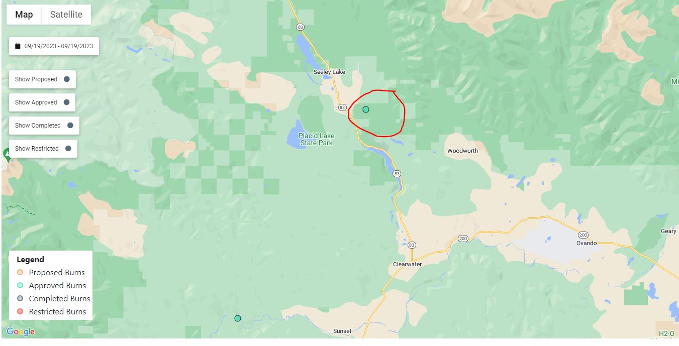
Seeley Ranger District:
Over the last two days fire personnel accomplished 135 acres of prescribed fire operations on the units southeast of Seeley. Today firefighters plan to finish 60 acres of prescribed burning on these units. Some residual smoke may be visible throughout the week from interior fuel pockets.
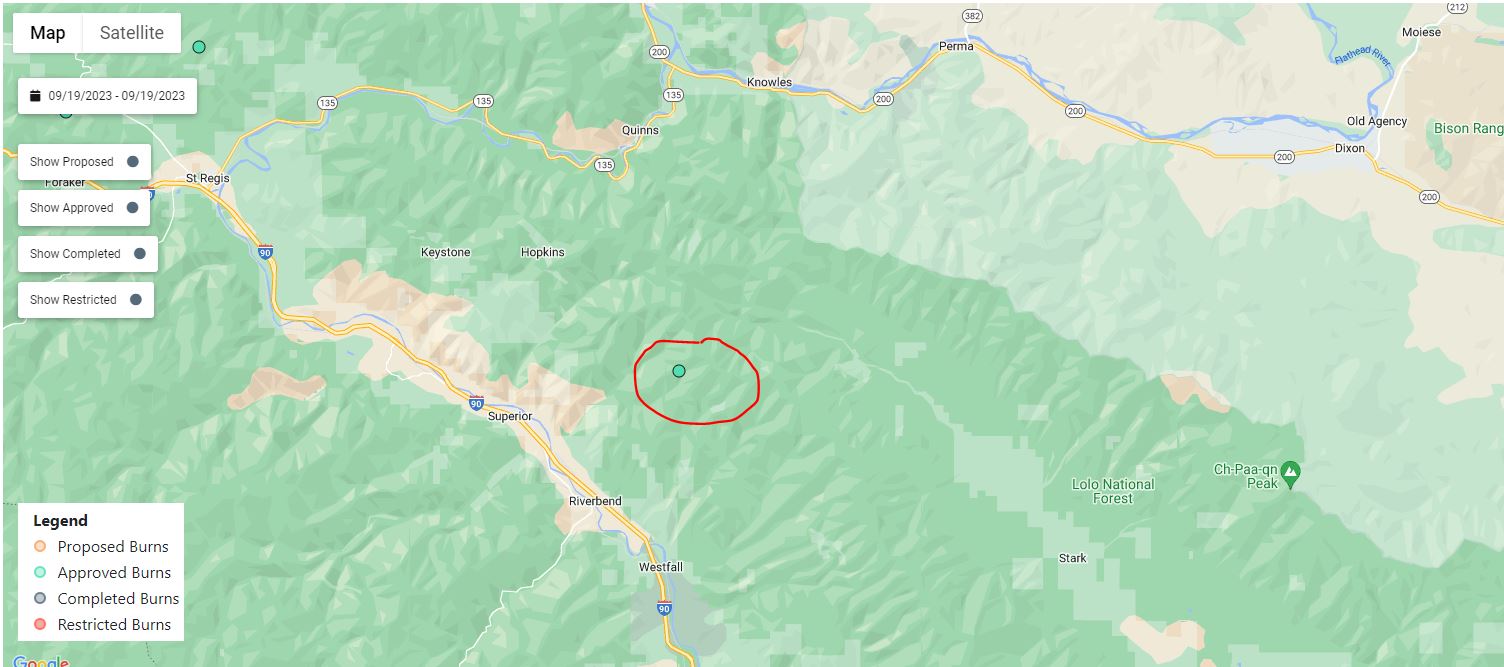
Superior Ranger District:
Firefighters will conduct up to 13 acres of prescribed burning 5 miles northeast of Superior near Johnson Creek. Smoke may be visible from Superior.
Prescribed fire is one of the most effective management tools used by the Forest Service. Prescribed fire allows fire managers to mimic the natural role of fire on the landscape helping to remove hazardous fuels, create a fire-adapted ecosystem, and restore wildlife habitat.
Continue to follow Facebook and InciWeb for the latest updates on prescribed fire.
Olympic National Park Fire Update September 18
Related Incident: 2023 Olympic National Park Lightning Fires
Publication Type: News
Port Angeles, Wash. – Fire activity was moderated by increased cloud cover and higher overnight relative humidity values, which are expected to persist for the coming days. The fires are being managed by a Type 3 incident management organization.
Thanks to mapping techniques not impacted by smoke, fire crews have determined the Delabarre fire covers approximately 3,500 acres. Delabarre is characterized by multiple spot fires within the rugged terrain of the park’s interior wilderness. The fire spread during last week’s critically dry period.
Fire crews continue to leverage natural barriers - including mountain ranges, high alpine zones, and rivers - to confine the fires. Helicopter bucket drops were used to limit the spread of the Delabarre fire to the northeast. Crews are using Promise Creek and the North Fork of the Quinault River to limit the Low Divide fire’s spread to the south.
Daily assessments and fire behavior analyses will continue. A Type 2 helicopter was used for bucket operations today and a Type 1 helicopter was ordered.
Fire Name
Initial Report
Estimated Size as of 9/5
Location
Hurricane
8/28/23
4 acres
2,000 ft below Hurricane Ridge parking area
Eagle Point
8/28/23
122 acres
~5 miles out Obstruction Point Road
Diamond Mountain
9/1/23
30 acres
3.3 miles NE of
Anderson Pass
Low Divide
9/1/23
312 acres
N. Fork Quinault drainage
Delabarre
9/1/23
3,554 acres
3 miles SE of Mount Christie
Martins Lake
9/2/23
108 acres
2 miles NE of Mount Christie
Mount Queets
9/14/23
4 acre
Summit of Mount Queets
Fire is an integral part of the forested ecosystems on the Olympic Peninsula; plants and animals here have evolved with fire for thousands of years. Many factors such as weather, topography, and vegetation influence fire behavior and the effects that fires have on natural resources.
Background Information
All seven active fires in Olympic National Park ignited when a series of lightning strikes occurred on the Olympic Peninsula in the afternoon on August 28.
Closures
Due to wildfire activity the following closures are in effect until further notice:
- Elwha River Trail from Elkhorn to Low Divide
- Hayden Pass Trail
- Dosewallips River Trail from Dose Meadows to Hayden Pass
- Dodger Point Way Trail
- North Fork Quinault Trail from Elip Creek trail junction to Low Divide
- Skyline Trail from Elip Creek Trail junction to Low Divide
- Martin Park Trail
- Obstruction Point Road and Trailhead
Olympic National Park Wilderness Information Center (WIC) will be notifying backcountry permit holders who may be impacted by these closures. Any permit holders who plan to backpack in the above impacted areas should contact the WIC at 360-565-2992 or by emailing OLYM_WIC@nps.gov.
Weather and Fire Behavior
Fire behavior is expected to moderate with a chance of precipitation Tuesday evening.
Information for the 2023 Olympic National Park Lightning Fires can be found at: https://inciweb.wildfire.gov/incident-information/waolp-2023-olympic-national-park-lightning-fires
Olympic National Park information: www.nps.gov/olym
Olympic National Forest information: www.fs.usda.gov/olympic
State and county area burn bans: https://ecology.wa.gov/Air-Climate/Air-quality/Smoke-fire/Burn-bans