
El Valle Fire 100 Contained
Related Incident: El Valle Fire
Publication Type: News
Fire crews fully contained the 525-acre El Valle Fire by the end of their shift Sunday evening. They will continue to maintain a presence in the area to patrol and mop-up interior heat before calling it controlled and out. Suppression repair activities will also continue.
“I want to thank all the firefighters that responded to this incident, especially those who responded immediately after smoke was first reported” said Incident Commander Fabian Montaño. “Working across boundaries is imperative for the success in all aspects of wildland fire.”
The following cooperators responded to the El Valle Fire to assist Carson National Forest fire crews, listed in alphabetical order:
- Albuquerque Fire Rescue
- Angel Fire Fire Department
- Black Hills National Forest (Tatanka Hotshots)
- Bureau of Land Management
- Chimayo Volunteer Fire Department
- Cochiti Volunteer Fire Department
- Coconino National Forest
- Durango (CO) Tanker Base
- Slide Mountain Hand Crew, North Lake Tahoe Fire Protection
- Dixon Volunteer Fire Department
- La Mesilla Volunteer Fire Department
- New Mexico State Forestry
- Ojo Sarco Volunteer Fire Department
- Penasco Volunteer Fire Department
- Picuris Pueblo
- Rio Grande Volunteer Fire Department
- Santa Fe County (Chimayo Fire District)
- Santa Fe City Fire Department
- Santa Fe National Forest
- Taos County Fire
- Taos Pueblo
Law enforcement, dispatch and ambulance services were provided by
- Bureau of Land Management
- Costilla (CO) County Sheriff's Department
- Durango (CO) Interagency Dispatch Center
- Mora County Sheriff’s Department
- New Mexico State Police
- Rio Arriba County Sheriff’s Department and Dispatch
- Taos County Sheriff’s Department and Dispatch
- US Forest Service
- Village of Questa*
Partnerships will continue to be critical to responses and forest management of the Carson National Forest, especially in the Enchanted Circle Landscape, which includes the El Valle Fire burn area. The landscape is a 1.5-million-acre area in and around the forest that is one of the most vulnerable areas in the country to wildfire and a priority for treatment under the national Wildfire Crisis Strategy.
For example, the Carson National Forest has entered into a Good Neighbor Agreement with Taos County to, in part, facilitate preparation and implementation of prescribed fire, including a portion of the El Valle Fire burn area, which was slated for pile burning this upcoming winter. An analysis and public discussions about that project area are forthcoming.
The El Valle Fire was first reported at 12:49 p.m. on Sep. 8, just south of El Valle, N.M. Ground and air resources responded, with over 160 fire personnel assigned at the height of the incident, including investigators who continue to look into the fire’s cause.
Weather greatly aided crews with the arrival of high relative humidities at first and then over an inch and a half of rain, as measured by a nearby remote automated weather station in Truchas, N.M.
The fire’s total size is 525 acres, with approximately 340 acres of National Forest land and 180 acres of non-Forest Service lands within the fire perimeter.
Settings - change map background and toggle additional layers
Filter - control incident types displayed on map.
Zoom to your location
Reset map zoom and position
Could not determine your location.
Show Legend
 Wildfire
 Prescribed Fire
 Burned Area
Response
Burned Area
Response Other
Other
Southwest Idaho Wildfire Crisis Strategy Prescribed Fire
Unit Information
Incident Contacts
Anvil and Flat Fire Smoke Outlook Sep 1819
Related Incident: Anvil FireFlat Fire
Publication Type: News
2023 SRF Lightning Complex Update September 18 2023
Related Incident: 2023 SRF Lightning Complex and Redwood Lightning Complex
Publication Type: News
Fire Update
2023 SRF Lightning Complex
Monday, September 18, 2023 – 9:00 a.m.
Eastern Area Gold Team
Brian Jenkins, Incident Commander
Information Phone: 530-536-0767
Email: 2023.lightningcomplex@firenet.gov
Information Staffing Hours: 8 am to 8 pm
Special Note: COMMUNITY MEETING: Wednesday, September 20th, 2023, at 6:00 p.m. Karuk Tribe DNR (39051 CA-96, Orleans, CA 95556)
This update covers 8 of the 14 fires being managed as part of the SRF Lightning Complex. The remaining 6 fires (Big Foot, Blue Creek, Creek, Flat, Iron, and Merrill) totaling 34 acres, are contained and in patrol status. They are checked daily, and their size and containment are unlikely to change.
Current Situation: The 14 fires in this incident total 26,408 acres and overall containment is 7%. The 8 uncontained fires described below total 26,374 acres. In total, 1,122 personnel are assigned to the incident. These fires are all on the Six Rivers National Forest and as of today, have been burning on the landscape for 34 days. Throughout this time, fire managers have continued to implement a full suppression strategy utilizing a variety of tactics. Containment of a fire is achieved by using a combination of man-made and natural barriers. During suppression, firefighter safety is our number one priority. The landscape where these fires are burning is very steep and often inaccessible. This compelled fire managers to look at alternative roads and ridge lines farther from the immediate fire perimeter that would allow for increased firefighter safety while still protecting the communities, cultural resources, and other values. Man-made containment of a fire is often constructed using a combination of handline, tree fallers, dozers, and masticators. Another highly effective tool to increase containment is to strategically introduce low-intensity fire to remove fuels from an advancing fire.
Decades of research shows that fire is critical for healthy forests and maintains important forest functions like water quality, clean air, and wildlife habitat. In addition, Indigenous traditional ecological knowledge supports the practice of cultural burning that was historically conducted by local Tribal Nations. The fire, weather, and fuel conditions on the 2023 SRF Lightning Complex have been favorable for using strategic firing operations to accomplish fire suppression, reduce the risk of future extreme wildfires, and uphold our responsibilities to Tribal Nations.
In support of historical fire regimes and cultural burning, but also recognizing our commitment to protect the community of Orleans, firing modules will continue strategically firing north of the Mosquito Fire along Cedar Camp Road, and eventually continuing north along the Go Road, and northeast along the 13N13 Road. In addition, Tribal members part of the Hoopa, Yurok, and Karuk, who are also assigned to this incident, will begin strategically firing north of the Go Road along Lightning Ridge and other adjacent ridgelines in the coming days. This practice will progress at a slow methodical pace over the next several days. Engines are being deployed at night in locations where firing has occurred to guard against any unexpected fire behavior.
Pearch Fire (7299 acres, 8% contained) – In response to the thunderstorms and wind gusts yesterday, fire fighters re-assessed the fire perimeter. Fire behavior continued to be moderate with fire slowly backing downhill into the Butler Creek and a portion of Somes Creek drainages on the northeastern side of the fire. On the west side, along Whitemore Creek, a hotshot crew used minimal strategic firing to bring low intensity fire down to Highway 96. They will continue using this parallel tactic throughout the week. The Structure Protection Group continued reinforcement and placed additional hoses. They will remain on the fire during both day and night shifts. Today, crews will continue to patrol completed fire lines, mop up and secure the fire perimeter on the south and west sides of the fire.
Bluff #1 (3750 acres, 29% contained) and Mosquito (4740 acres, 11% contained) Fires – Yesterday on Bluff #1, crews continued to patrol and contain the fire north of Onion Road. As a result, there was minimal fire growth on the south end of the fire. On the northeast end of Bluff #1, crews continued to tactically ignite along Bluff Creek Road and will continue to do so today. On the south end of the Mosquito Fire, fire behavior was similar to previous days and crews continued to maintain the south and west containment lines. On the north end, parallel to Cedar Camp Road and Road 12N13, strategic firing was introduced to removed unburned fuel and strengthen containment lines. A contingency of engines remains on both fires throughout the nighttime hours. Following discussions among the team, agencies, and tribal leaders a plan and alignment has been agreed upon to use crews and masticator equipment to begin widening the Bluff Creek Road to the south of Bluff #1 Fire. The long-term objective is to build a stronger fuel break line to protect and preserve the tribal lands to the west.
Blue Creek #2 (8575 acres, 0% contained) and Marlow (1917 acres, 0% contained) Fires – These fires are bounded by indirect control lines to the east and south and prior fire footprints where fuels are lighter. Fire growth was moderate yesterday. Dead material from a 2008 fire continue to burn in the interior as the 3 fires merge together. The Copper and Blue Creek #2 Fires have merged and going forward will only be referred to as the Blue Cree #2 Fire. No values are currently threatened. A Wildland Fire Module continues to monitor and assess conditions on the ground and air resources will monitor from above. Fire managers from the 2023 SRF Lightning Complex are coordinating daily with fire managers on the Happy Camp Complex due to the proximity of the Elliot Fire.
Monument (2 acres, 0% contained) and Let er-Buck (89 acres, 0% contained) Fires – Due to limited values at risk, the remote, steep terrain and associated safety concerns for our firefighters, these fires are being addressed with a confinement strategy. Terrain, natural fire barriers such as rock outcroppings, and old fire footprints where fuels are limited will be used to confine fire growth until season ending precipitation extinguishes the fires. These fires are checked regularly by aerial patrols to ensure they remain within acceptable bounds.
Weather: Temperatures will cool today by 5 degrees and increase the relative humidity 5-10%. The increased onshore flow will support breezier westerly conditions. Up-canyon winds 10-15 mph will develop this afternoon. Highs will be in the upper 80s in the valleys and upper 70s to lower 80s on ridges. Smoke will persist in the valleys through the day.
Closures
Six Rivers National Forest: Area and campground closures are in effect on portions of Six Rivers National Forest. They can be found at: https://www.fs.usda.gov/detail/srnf/notices/?cid=FSEPRD1096395.
Additional Fire Information
www.linktr.ee/srffitrpio
www.linktr.ee/srffitrpio
Facebook: https://www.facebook.com/2023SRFRedwoodLightning
More Fire Information Links: www.linktr.ee/srffirepio
For Air Quality Information: www.airnow.gov
NOTE: For information about the Elliot or Hancock Fires which are part of the
Happy Camp Complex, please visit https://linktr.ee/happycampcomplex2023 .
Informacin actual para el Incendio Smith River Complex North 18 de septiembre de 2023
Related Incident: Smith River Complex
Publication Type: News
Area: 92,180 total/12,460 en Oregon
Inicio: August 15, 2023
Localizado: Grants Pass, OR
Contención: 65%
Personal: 1,473/ Complejo
Causa: Relámpago
Recursos: 37 escuadrillas de bomberos 11 helicópteros 66 camiones de bomberos 8 buldóceres 26 cisternas 14 máquinas masticadoras 1 cargador compacto
Reporte de las actividades acaecidas el día de ayer: Se incremento la línea de contención sobre el borde Noreste del incendio, logrando contener el fuego a un 65%. Los manejadores del incendio confían que el fuego no cruzara dicha línea, aunque las condiciones climáticas signifiquen un reto para los bomberos.
Se puede observar una mínima actividad del incendio en el interior del área. Sobre el área Noroeste las escuadrillas de bomberos han limpiado áreas con vegetación que aún no se había quemado. La actividad del fuego se incrementó ligeramente en la zona de las líneas eléctricas y en donde se han mantenido las líneas de contención.
Actividades para el día de hoy: Las escuadrillas de bomberos continuaran monitoreando, limpiando y asegurando el control de las porciones Norte y Noroeste de los bordes del incendio y continuaran protegiendo el corredor de las líneas eléctricas a lo largo de la carretera 316.
Sobre el lado Oeste, debido a que la propagación del fuego actualmente no representa un peligro, los bomberos se encuentran retirando las mangueras, tanques temporales de agua y otra infraestructura de supresión establecidas alrededor de las propiedades privadas.
Condiciones del humo: Sobre el área del incendio, el día de hoy, se espera una disminución en la presencia del humo acompañado con una reducción en la actividad del incendio. La calidad del aire en Grants Pass, Medford y Ashland, caerá en el rango de nivel BUENO; para el área de O’Brien y Cave Junction, experimentaran el impacto del humo en horas de la tarde. Los niveles de humo pueden cambiar rápidamente dependiendo de las condiciones climáticas; chequee las condiciones actuales en: https://bit.ly/SWORsmoke
Ordenes de cierres: A partir del día de ayer, 14 de septiembre de 2023, el Bosque Nacional de Rogue River Siskiyou ha dictado un cierre de área y carreteras para un corredor de 400 yardas de ancho centralizado en las Carreteras Forestales 1106 (South Elk Mountain Road), 1205 (Lower Wheeler Road) y 1983 (Mt. Emily Road). Esta acción tiene como objetivo el permitir realizar operaciones relacionadas con el Incendio Smith River Complex Norte, sin riesgo alguno para los bomberos. Asimismo, se encuentran en pie las ordenes de cierre para las tierras de BLM. Para información adicional, visite: bit.ly/RRSNFAlerts o https://www.blm.gov/orwafire .
Cierre de carreteras y retrasos: Caltrans en el condado de Del Norte, ha publicado un horario del cierre de carreteras y restricciones en las líneas de tráfico, para el Hwy. US 199. Durante los días de semana, se dará una combinación de horarios y una variación en las restricciones sobre líneas de tráfico. Durante los fines de semana, la carretera permanecerá abierta, pero con restricciones de línea de trafico y guiados por un carro piloto. Este preparado para retrasos. Para una información más específica acerca del acceso de carreteras, por favor lea los reportes en el sitio de Caltrans Quickmap: https://quickmap.dot.ca.gov/ y Oregon Department of Transportation’s https://www.tripcheck.com/. Las autoridades locales, no están recomendando el uso de esta ruta para realizar viajes considerados no esenciales.
Por favor no se guie a través de sistemas de Navegación y mapas. Estos programas han estado dirigiendo a las personas dentro de áreas con actividad de incendio. Por favor no utilice las carreteras forestales como una ruta alternativa.
Evacuaciones: Por favor monitoree el sitio para el Manejo de Emergencia de Rogue Valley y regístrese para el Sistema de Alertas y actualizaciones en https://rvem.org. También puede encontrar un Mapa Interactivo de Respuesta Inicial de Incendio, en donde se muestran las áreas de evacuación para las zonas afectadas.
Orden de Restricción: Por favor respete la Orden Temporal de restricción de vuelos (TFR) establecida para el Incendio Smith River Complex; mantenga drones fuera de las operaciones de incendios. Si Usted vuela, nosotros no podemos. ¡No sea la razón por la cual las misiones aéreas tengan que ser desviadas! Informe detallado: https://tfr.faa.gov.
Actualizacin sobre los incendios de Anvil y Flat 17 de Septiembre
Related Incident: Anvil FireFlat Fire
Publication Type: News
Se realizará una reunión comunitaria el martes 19 de septiembre a las 7 PM en el salón de Sixes Grange, y será transmitida en vivo a través de Facebook (enlace abajo). Los gestores del incendio y los representantes de las agencias locales compartirán información y responderán preguntas sobre los incendios de Anvil y Flat.
Incendio de Anvil
Tamaño: 7,681 acres | Fecha de inicio: 25 de agosto de 2023 | Ubicación: 8 millas al este de Port Orford, OR | Contención: 0% | Personal total: 684 recursos | Recursos: 9 equipos, 4 helicópteros, 10 camiones de bomberos
Ayer, los equipos, así como los recursos de maquinaria pesada y aéreos aprovecharon las condiciones favorables del clima. Muchas de las misiones operativas se completaron con éxito con la ayuda de personal adicional. Los camiones de bomberos, incluyendo los recursos nocturnos, activaron las bombas de agua y los rociadores cerca de viviendas para aumentar los niveles de humedad y reducir la probabilidad de que comience un incendio cerca de los combustibles. Los equipos manuales comenzaron una operación de quema en Grassy Knob, hacia el criadero de peces y Elk River Road, para reducir la vegetación y crear una línea de contención fácil de defender como medida de prevención ante el pronóstico de advertencia de bandera roja por vientos fuertes.
Ayer en la tarde, cuando el humo se despejó, los helicópteros vertieron más de 45,000 galones de agua para ayudar a los bomberos. Los buldóceres terminaron las líneas de contención primarias y de contingencia en zonas estratégicas donde el terreno es ideal para usarlas y donde tienen mayor probabilidad de disminuir la propagación del incendio en caso de que el fuego alcance las líneas. Los equipos seguirán trabajando hasta altas horas de la noche para limitar de forma segura y efectiva la propagación del incendio, sobre todo al oeste y al norte. Los bomberos están identificando caminos y las características naturales, incluyendo Elk River y el sendero adyacente, como posibles líneas de contención mientras evalúan de manera estratégica las mejores formas para extinguir el fuego por completo. Aumentó la cantidad de recursos asignados al incendio, incluido el personal médico presencial en caso de cualquier lesión o accidente que puedan sufrir los bomberos que trabajan en un terreno extremadamente difícil.
Evacuaciones: La oficina del sheriff del condado de Curry identificó cuatro zonas de evacuación alrededor del incendio de Anvil. Tiene a disposición un mapa interactivo de evacuación en https://bit.ly/45UIh2E. Las zonas 1 y 4 se encuentran en nivel 3 de evacuación ("Salir"). Las zonas 2 y 3 tienen un nivel 2 de evacuación ("Preparados para salir"). Suscríbase para recibir alertas de emergencia del condado de Curry en https://bit.ly/CurryCoEM.
Incendio de Flat
Tamaño: 34,242 acres | Fecha de inicio: 15 de julio de 2023 | Ubicación: 2 millas al sureste de Agness, OR | Contención: 75% | Personal total: 102 | Recursos: 2 equipos, 3 helicópteros, 5 camiones de bomberos
Se espera que el miércoles se terminen todos los trabajos de reparación de terreno en las líneas de contención de contención. Cinco camiones de bomberos seguirán supervisando el incendio y responderán tan pronto como sea necesario ante cualquier aumento de la actividad del fuego.
Información general
Clima: Está vigente una advertencia de bandera roja en la zona del incendio desde la medianoche del domingo hasta el lunes a las 9 AM. Esta advertencia significa que las condiciones climáticas podrían contribuir al crecimiento del incendio. Se espera que los vientos altos alcancen de 20 a 25 mph, con ráfagas de 27 mph. La humedad relativa también será baja. A final de la semana se pronostican más vientos del norte/noreste. Los gestores del incendio se preparan con las agencias locales para hacer frente a estos eventos climáticos y al impacto que tendrán en los incendios.
Humo: Visite https://bit.ly/SWORsmoke para actualizarse sobre la calidad del humo y del aire.
Cierres de áreas y caminos: Para la seguridad de los bomberos y del público, el Bosque Nacional Rogue River-Siskiyou emitió órdenes de cierre para las zonas afectadas por los incendios de Anvil y Flat. Visite https://bit.ly/RRSNFAlerts para tener información y un mapa de los caminos cerrados. Los campamentos Edson y Sixes de la Oficina de gestión territorial están cerrados hasta nuevo aviso.
Anvil and Flat Fire Community Meeting September 19 at 7pm
Related Incident: Anvil FireFlat Fire
Publication Type: Announcement
A community meeting will be held for the Anvil Fire on Tuesday, September 19 at 7:00 p.m. at The Grange (44556 Highway 101) in Sixes. If internet connection allows, the meeting will be broadcast on Facebook Live. Otherwise, it will be recorded and posted to Facebook afterwards.
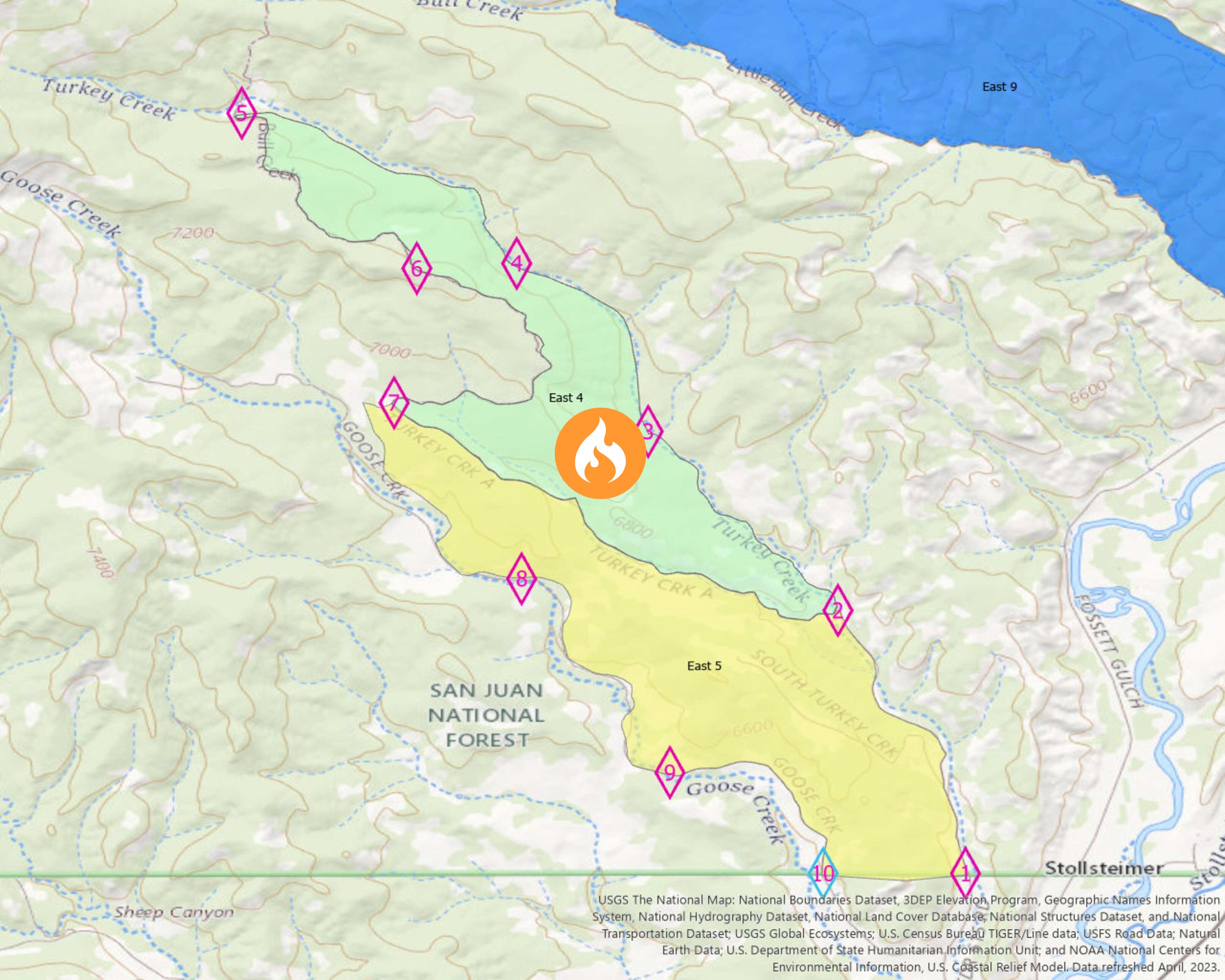
Columbine District Southern HD Unit Prescribed Fire East 4 Block 09182023
Related Incident: 2025 San Juan National Forest Prescribed Fire Program
Publication Type: News
**POSTPONED**
Due to unfavorable weather conditions, the USDA-San Juan National Forest will postpone todays planned prescription burn on the Southern HD Unit, East 4 Block. Today's planned 500-acre prescription burn was set to start at 10am. Winds are expected to pick up mid-day, producing gusts up to 30+mph. Wind is a driving factor for prescription burns and must fall within the prescription guidelines in order to start ignition. USDA-San Juan National Forest will re-schedule the burn on the East 4 Block of the Southern HD Unit at a later date when weather conditions are more favorable.
Camp Creek Fire Daily Update for Sunday September 18
Related Incident: Camp Creek Fire
Publication Type: News
September 18, 2023
Camp Creek Fire Update
Size: 2,055 acres
Start Date: August 25, 2023
Cause: naturally caused, lightning
Location: 1.5 miles south of Bull Run Reservoir #1 near the junction of Forest Roads 1210 and 12
Containment: 51%
Total personnel: 395
Resources: 13 engines l 5 crews l 6 water tenders l 4 heavy equipment l 3 helicopters l 2 scooper aircrafts
Current Situation: There has been little to no growth of the Camp Creek fire in the last week where firefighters have been engaged in suppression activities to hold the fire within the existing footprint. The fire is burning in heavy fuels that include deep duff, decayed logs, and timber litter under a dense canopy. These heavy fuels dried out during the summer and will continue to smolder and burn in place with some creeping and minimal fire activity until there is significant precipitation.
Today’s Activities: Today firefighters will continue mopping up the fireline to remove heat and minimize the likelihood of the fire burning into unburned areas. They will also continue hauling away vegetation debris created from fireline preparation. Along contained portions of the fire, firefighters will patrol the fireline to check for and extinguish any hotspots. They will also continue removing excess hose and other equipment that is no longer needed and they will be repairing any damage caused during fire suppression activities, returning affected areas to pre-fire conditions as nearly as possible.
Weather: Conditions have transitioned to more seasonal cool and moist weather. With the change in weather, only minimal fire activity is expected. Cool and moist conditions will continue through mid- week and winds will remain light out of the west. There is a chance of widespread light rain with the next front coming across the region Tuesday night into Wednesday.
Smoke: Current smoke outlook: https://outlooks.wildlandfiresmoke.net/outlook/2c7a8f9b
Closures: Barlow Wayside Park and the Sandy Ridge Recreation Site are temporarily closed due to fire activity. Clackamas County residents can sign up at https://www.clackamas.us/dm/publicalerts to receive emergency alerts via email, phone, or text.
Restrictions: A Temporary Flight Restriction (TFR) is issued over the fire area. It is illegal for the public to fly drones over or near wildfires because of the potential for accidents and disruption of suppression operations. Regardless of the fire, aircraft is not permitted to fly over the Bull Run watershed.
Operational Briefing Video: View the September 17, Operation Video on or Facebook
Happy Camp Complex Daily Update September 18 2023
Related Incident: 2023 Happy Camp Complex Klamath NF
Publication Type: News
Monday, September 18, 2023
WEATHER: Slightly cooler conditions with breezy northeast winds are forecast through the week. In the Happy Camp and Scott Bar areas, air quality has been poor and limits visibility for driving and aircraft.
FIRE BEHAVIOR: Minimal fire activity expected, but prepare for increasing winds. Fuels continue to dry out and are ready to burn. The Forest received numerous lightning strikes and so far there are 12 reported fires. The largest fire is approximately 28 acres near Wild Lake. Resources assigned to the fire are assisting with initial attack.
WEST SIDE OVERVIEW (acres/containment): Elliot (10,017 acres, 52%),
UFish (6,545 acres, 38%), Hancock (1,729 acres, 100%).
On the UFish Fire, burnout operations may be necessary to keep fire within established firelines. Crews will continue to improve roads as contingency lines. Crews will continue to patrol and mop-up between Pony Peak, Browns Creek and the Klamath River. Resource Advisors continue to work with crews to determine and implement appropriate suppression repairs.
EAST SIDE OVERVIEW (acres/containment): Head (6,954 acres, 100%), Townsend (81 acres, 100%), Den (294 acres, 100%), Scott (918 acres, 100%),
Lake (200, acres, 100%), Kings (2 acres, 100%).
All fires on the east side of the Complex continue to be patrolled by infrared flights, as needed, to detect residual heat in the fire areas.
Due to fires on the Happy Camp Complex, the Six Rivers Lightning Complex, Smith River Complex, and fire activity occurring as far away as the Canadian region, increased smoke can be expected in Happy Camp, Seiad Valley, and surrounding communities. For more information on the Six Rivers Lightning Complex, go to http://www.linktr.ee/srffirepio.
EVACUATIONS: View current Siskiyou County evacuation orders and warnings by visiting https://community.zonehaven.com. Siskiyou County residents are encouraged to sign up for rapid emergency notifications using the CodeRED emergency alert system at: https://bit.ly/SiskiyouCodeRedEmergencyAlert.
CLOSURES: A closure order has been implemented in the Klamath National Forest. Find more information at https://bit.ly/KlamathNFAlertsNotices.
As hunting season begins, please be aware of area closures within national forests. Contact local Forest Service offices for specific information.
DELAYS: One-way traffic control is on Highway 96 at various locations, from 5 miles east of Seiad to the Klamath River. Scott River Road is closed between Highway 96 and Mill Creek Road. Elk Creek Road is closed south of Forest Route 15N10 due to a washout. The Pacific Crest Trail is closed from the junction of Shelly Fork Trail at mile 1611.8 north to Seiad Valley at mile 1657.5. An area closure is in effect between Seiad Valley and Oak Knoll, expanding north to FS12 road and south to Scott River Road. Motorists can expect delays in this area. For more information: https://roads.dot.ca.gov/.