
Pagosa Ranger DistrictEcho Canyon UnitPrescribed Fire 9252023
Related Incident: 2025 San Juan National Forest Prescribed Fire Program
Publication Type: News
Ignitions for the prescribed burning operation began today, September 25th, 2023, at 11am on the Echo Canyon Unit block within the Pagosa Ranger District, USDA Forest Service - San Juan National Forest. Today's operation is located west of Rito Blanco Ranch on the southern end of the #SanJuanNF. Resources have scheduled to burn blocks 1 and 2, on the north end of the Echo Canyon Unit, for a total of 550-acre goal.
70 firefighters will work to execute this prescribed fire, aimed at reducing hazardous ground fuels, reducing the risk of unplanned catastrophic wildfire, restoring ponderosa pine ecosystems, and improving wildlife habitat.
If you are in the area, please exercise extreme caution when around firefighters and fire apparatuses. Some smoke may be visible in the area.
Hope Fire burning on the Dolores Ranger District
Related Incident: Hope Fire
Publication Type: News
Lightning-caused fire in Montezuma County
DOLORES, Colo., September 25th, 2023—The Hope Fire on the Dolores Ranger District of the San Juan National Forest was reported on September 21st at 3:46pm. It is currently burning at Hoppe Point located northwest of the McPhee Dam and Reservoir, east of Bradfield Campground. It is approximately 30 acres in size at this time. Fire managers are working to implement a suppression strategy that involves containing the fire within previously defined and prepared control lines to allow this naturally caused wildfire to reduce forest fuels and improve forest health within those boundaries. Fire behavior so far has been minimal and there are no structures threatened.
The Hope Fire is burning in a prescribed fire burn unit. Local San Juan resources have been working to prepare lines around the estimated 3,000-acre section and will continue this work. An InciWeb page has been established for this incident for up-to-date information.
This type of fire suppression tactic lowers the risk of future catastrophic wildfire by reducing the amount of fuel on the ground and thinning, with fire, surface fuels, the understory and oak brush. Low-to-moderate intensity fire also improves forage for wildlife by creating growing room for grasses and other plants. These efforts align with the Forest Service's 10-year Wildfire Crisis Strategy, which aims to increase the use of fire on the landscape as well as other treatments to improve forest resiliency for generations to come.
In today’s plan, fire personnel will continue securing the fire and planned control lines. When weather conditions are favorable and it is safe to do so, firefighters will then add fire, utilizing drip torches to contain the fire indirectly.
Smoke from the Hope Fire may be visible to Dolores, Cortez, and surrounding communities, as well as McPhee Reservoir and travelers on Highway 160 and 491. Hope Fire smoke may affect your health. For more information, please go to: https://www.colorado.gov/pacific/cdphe/wood-smoke-and-health
For more information on the Hope Fire, please contact the Public Information Line at or (541) 802 3112 or by email at 2023.hopefire@firenet.gov.
For current updates, visit InciWeb: https://inciweb.nwcg.gov/incident-information/cosjf-hope-fire
For information about the San Juan National Forest, call (970) 247-4874, visit the forest website, or follow us on social media (Twitter and Facebook).
-USDA-
USDA is an equal opportunity provider, employer, and lender.
Curry County Sheriff Reduces Anvil Fire Evacuation Levels Sept 25
Related Incident: Anvil Fire
Publication Type: Announcement
Due to the current rain event and in conjunction with the Fire Incident Management Team assigned to the Anvil Fire, the Curry County Sheriff is reducing the evacuation levels currently in place.
Today at 2:00pm, notifications of the decrease in evacuation zones of Level III (Go Now) will be reduced to Level II (Get Set) in the area of Elk River Road from Milepost 4 to the Butler Bar Campground. Even though the Level III is being reduced, the Forest Service Road from Elk River Fish Hatchery to Butler Bar Campground will still be closed to the public for now.
The Curry County Sheriff’s Office along with the Fire Incident Command and the Coos Forest Protection Association (CFPA) want you to know that even though the Level III is being reduced, there still will be fire fighters and fire equipment in those areas and to be aware of your surroundings. If we get another warming event and the fire behavior increases, we may need to re-instate Level III. The fire is not out, it has been put in its place for now by the help of the weather.
The current Level II from U.S. Highway to milepost 4 on the Elk River Road will also be reduced back to Level I. The Level II from the Edson Creek Campground to the Sixes River Campground on Sixes River Road will remain in effect for now.
I am pleased to let you all know who were in the closure areas that you can return to your homes. Just remember to be prepared and stay informed. It is due to the USFS District Supervisors, dedicated fire crews, Incident Commands, local fire agencies, local timber companies and CFPA for all the work they did in fighting these fires and not losing any homes.
Sheriff John Ward
Actualizacin del Incendio del Complejo Cowlitz 25 de septiembre de 2023
Related Incident: Cowlitz Complex
Publication Type: News
25 de septiembre de 2023
Continúa la reparación de la extinción en el Complejo Cowlitz
(RANDLE, Wash.) – El Complejo Cowlitz está contenido en un 39% con un total de 731 acres quemados.
El Equipo de Gestión de Incidentes Tipo 3 del Oeste de Washington, dirigido por el Comandante de Incidentes Kent Stanford, ha asumido la gestión de los incendios del Complejo Cowlitz. Actualmente hay 247 recursos asignados al Complejo Cowlitz. Las tripulaciones seguirán trabajando con asesores de recursos (READs) para ayudar con las recomendaciones para las estrategias de reparación de extinción de incendios. Los bomberos siguen caminando en el fuego como parte de la evaluación y patrullaje. Ayer los bomberos no identificaron humo, ni movimiento activo. A medida que el incendio se vuelva más seguro, el equipo seguirá enviando recursos adicionales a casa.
El tiempo: La lluvia continuará durante la semana disminuyendo la actividad de los incendios complejos restantes.
Mensaje de seguridad: Con las fuertes lluvias, el suelo está mojado con agua estancada en algunos lugares. Todo está resbaladizo, así que tenga cuidado al viajar. A medida que los incendios continúan bajo control, más recursos se dirigirán a casa. Por favor, sea consciente de tráfico de fuego en y alrededor de las áreas de fuego. También es temporada de cacería, así que tenga cuidado y use colores brillantes cuando se recrea en la zona.
Antecedentes: Hubo 30 incendios en el complejo. Los incendios se iniciaron el 25 de agosto tras un rayo que cayó sobre el bosque nacional de Gifford Pinchot. La mayoría se han contenido y se encuentran en estado de patrulla o vigilancia mientras continúan las reparaciones de extinción.
Restricciones de quema de bosques: Los bosques nacionales de Mount Hood y Gifford Pinchot han rescindido las restricciones de quema de uso público. Para obtener información actualizada, visite su sitio web https://www.fs.usda.gov/main/mthood/fire y https://www.fs.usda.gov/main/giffordpinchot/fire.
Restricciones de quema en el condado de Lewis: La prohibición de quemar en la zona no incorporada del condado de Lewis sigue en vigor. Sólo se permiten fuegos recreativos y barbacoas de carbón o madera. Para obtener información sobre las restricciones de quema en el uso de la tierra regulada por el Departamento de Recursos Naturales del Estado de Washington (DNR) por favor visite su sitio web en https://burnportal.dnr.wa.gov
Cierres: Debido a las actividades de los incendios en curso, los siguientes caminos y senderos están cerrados al público para ayudar a garantizar la seguridad pública y de los bomberos: Carreteras forestales 25, 9300 y 9341, Boundary Trail #1 (desde Elk Pass hasta la intersección con Summit Prairie), Summit Prairie #2, Craggy Peak #3, Snagtooth #4, Quartz #5, Stabler Camp 17, Wright Meadows #80, Basin Camp #3A, Quartz #5B (French Creek), Snyder Pasture #80A.
Restricciones Temporales de Vuelo: El TFR se reduce a una sola área que abarca un radio de 5 millas al este de Randle. El TFR está en vigor durante las horas diurnas para incluir el apoyo al incendio Grassy Mountain. La respuesta de la aviación contra incendios se detiene o retrasa si una aeronave no autorizada entra en el TFR. Las restricciones temporales de vuelo también se aplican a las aeronaves no tripuladas o drones. Para más información: https://tfr.faa.gov/save_pages/detail_3_3758.html
###
Cowlitz Complex Daily Update September 25 2023
Related Incident: Cowlitz Complex
Publication Type: News
September 25, 2023
Suppression Repair Continues at the Cowlitz Complex
(RANDLE, Wash.) – The Cowlitz Complex is 39% contained with a total of 731 acres burned.
The Western Washington Type 3 Incident Management Team led by Incident Commander Kent Stanford has management of the Cowlitz Complex fires. There are currently 247 resources assigned to the Cowlitz Complex. Crews will continue working with Resource Advisor (READs) to help with recommendations for fire suppression repair strategies. Firefighters continue to hike into the fire as part of assessing and patrolling. Yesterday firefighters identified no smoke, nor active movement. As the fire becomes more secure, the team will continue sending extra resources home.
Weather: Rain will continue through the week decreasing fire activity among the remaining complex fires. We received an estimated one-half inch of rain across the fire area yesterday.
Safety Message: With heavy rains, the ground is wet with standing water in places. Everything is slick so use caution when traveling. As the fires continue to come under control, more resources will be heading home. Please be mindful of fire traffic in and around the fire areas. It is also hunting season so please use caution and wear bright colors when recreating in the area.
Background: There were 30 fires in the complex. The fires started August 25th after a lightning event across the Gifford Pinchot National Forest. Most have been contained and are in patrol or monitor status as suppression repair continues.
Forest Burn Restrictions: The Mount Hood and Gifford Pinchot National Forest have rescinded public use fire restrictions. For current information, please visit their website at https://www.fs.usda.gov/main/mthood/fire and https://www.fs.usda.gov/main/giffordpinchot/fire.
Lewis County Burn Restrictions: A burn ban in unincorporated Lewis County remains in effect. Only recreational fires and charcoal or wood BBQs are permitted. For information on burn restrictions on land use regulated by the Washington State Department of Natural Resources (DNR) please visit their website at https://burnportal.dnr.wa.gov
Closures: Due to ongoing fire activities, the following roads and trails are closed to the public to help ensure public and firefighter safety: Forest Roads 25, 9300 and 9341, Boundary Trail #1 (from Elk Pass to intersection with Summit Prairie), Summit Prairie #2, Craggy Peak #3, Snagtooth #4, Quartz #5, Stabler Camp 17, Wright Meadows #80, Basin Camp #3A, Quartz #5B (French Creek), Snyder Pasture #80A.
Temporary Flight Restrictions: The TFR is reduced to one single area encompassing a 5-mile radius east of Randle. The TFR is in effect during daylight hours to include support for the Grassy Mountain Fire. Fire aviation response is halted or delayed if an unauthorized aircraft enters the TFR. Temporary flight restrictions also apply to unmanned aircraft or drones. For more information: https://tfr.faa.gov/save_pages/detail_3_3758.html
###
Happy Camp Complex Daily Update September 25 2023
Related Incident: 2023 Happy Camp Complex Klamath NF
Publication Type: News
Monday, September 25, 2023
WEATHER: Much needed rain will dominate the fire area today into Tuesday morning accompanied by a cooler, windier trend. Monday afternoon the wind will be 10-15 mph with gusts up to 25mph and up to 30mph on ridgetops. Significant rainfall is expected within this system with 0.50-0.75-inch likely, and up to 1.25 inches in isolated areas and in higher terrain. The heaviest rainfall is expected Monday morning and will continue throughout the day.
Fire Restrictions: Fire restrictions remain in place to help minimize the chances of human-caused wildland fires. These restrictions prohibit campfires outside of established recreation and wilderness areas. https://bit.ly/KlamathNFAlertsNotices
FIRE BEHAVIOR: Wind from this weather system is expected to have little impact over most of the fire area. Available fuels will continue to be consumed within the perimeter before and during the rainfall.
UFISH FIRE: 7,603 acres at 75% containment.
ELLIOT FIRE: 13,649 acres at 70% containment.
Firefighters will get a much-needed break today as forecasted rain will provide them a chance to evaluate the ability to access the fire line safely in the Titus Creek drainage. Resources will evaluate the at-risk cultural and natural resources, the community of Happy Camp, critical infrastructure that serves Happy Camp, Highway 96, the Klamath National Wild and Scenic River, and the Siskiyou Wilderness. The Titus Creek drainage remains a priority for the Ufish Fire. Open lines are being monitored by firefighters on the ground. Swillup Creek to Pony Peak and into Dillon Creek is a priority for the Elliot Fire.
No significant movement or fire growth is anticipated in this area.
Hazard tree removal remains a priority. Crews are working in the Bear Creek area.Weather permitting, suppression repair will continue along multiple areas of the incident as crews continue to backhaul equipment and pull hose off the line on the Ufish Fire.
Patrolling and mop-up will also continue as weather permits today.
SMOKE EFFECTS: Yesterday, air quality greatly improved near the I-5 corridor and in Scott Valley due to favorable winds from the south and very little smoke production across the area. Smoke lingered in Happy Camp and along Highway 96 but improved as the day progressed. For today, we should see those same favorable winds in the morning as we await the rain. Precipitation will begin about midday and will continue through tomorrow morning. This rain event will bring ‘Good’ air quality across the region and will last for the next several days. For more details on smoke movement, go to Wildfire Smoke Outlook.
EVACUATIONS: View current Siskiyou County evacuation orders and warnings by visiting https://community.zonehaven.com. Siskiyou County residents, make sure you are signed up for the CodeRED emergency alert system at: https://bit.ly/SiskiyouCodeRedEmergencyAlert.
CLOSURES: A closure order has been implemented in the Klamath National Forest. Find more information at https://bit.ly/KlamathNFAlertsNotices.
As hunting season continues, please be aware of area closures within our national forests. Contact local Forest Service offices for specific information.
DELAYS: One-way traffic control is on Highway 96 at various locations, from 5 miles east of Seiad to Klamath River. https://roads.dot.ca.gov/
Morgan Fire Daily Update for September 25 2023
Related Incident: Morgan Fire
Publication Type: News
Morgan Fire Update: Monday, September 25, 2023
Fire Information line: 541-460-7602 8am-8pm
The Morgan Fire is burning in steep, forested terrain, approximately 21 miles northwest of Lakeview, Oregon and 8 miles north of Quartz Mountain, on both private and National Forest System lands.
Temporary Road Closure: The Fremont-Winema National Forest issued a temporary closure for public safety on a segment of Forest Service Road 2800, between its junction with Forest Road 3428 on the north and Forest Road 2800-016 on the south. A copy of the order and map is on the Forest website: https://www.fs.usda.gov/fremont-winema
Yesterday: Firefighters focused on mopping up into a 100-foot perimeter on the north end of the fire. Around the rest of the fire crews continue to mop up and strengthen fire lines. Hazard tree felling continues as a high priority to ensure that firefighters will have safe access and egress if high winds cause fire-weakened trees to fall across roads. Crews used a helicopter to drop water on and extinguish hot spots on the west side of the fire.
Today’s Activities: Firefighters will deepen their mop up operations along the perimeter and continue felling hazard trees. Firefighters will focus on the north end of the fire in anticipation of strong southerly winds that could challenge containment lines. An infrared detection unmanned aerial system (drone) will be in use to find any hidden heat sources that could threaten fire lines in windy conditions.
Weather: A Red Flag Warning is in effect for the Morgan Fire this afternoon into the evening. Strong southwesterly winds coupled with low relative humidity (15-25%) will result in critical fire weather conditions. Gusts up to 45-50 mph are possible Monday, especially on higher slopes and exposed/wind aligned areas.
Evacuations: There is currently a Level 1 (“Get Ready”) Evacuation. Evacuation maps are posted on the Morgan Fire Inciweb page and the Lake County, OR website: https://www.lakecountyor.org/
Be wildfire aware! Avoid activities that can cause an accidental spark.
https://www.readyforwildfire.org/prevent-wildfire.
Fire Information and Links
Inciweb: https://inciweb.nwcg.gov/incident-information/orfwf-morgan-fire
Facebook: https://www.facebook.com/nwteam7
Smith River Complex South Daily Update September 25 2023
Related Incident: Smith River Complex
Publication Type: News
***Flood Watch in Effect From 5 AM To 11 PM Monday***Wind Advisory in Effect Through 1 PM Monday***
CURRENT SITUATION: The expected storm arrived off the coast early this morning bringing strong winds and rain throughout the Smith River Complex. The system today is potentially going to bring rainfall between 2 to 3 inches over the next 12 hours and the runoff has the potential for mud slides and debris flows that could impact highways and the roads in and around the fire footprint.
The safety of the public and our firefighters is the top priority for the fire management team and that’s a crucial and responsible approach when dealing with incidents. During each incident the management team creates a set of management objectives, managing risk to responders and the public by ensuring hazards are identified, assessed, and mitigated with Team 4 is always number one. Team 4’s end goal is to always minimize the impact to natural, cultural, wildlife and heritage resources. With these objectives in mind, crews and equipment have been relocated to safe and strategic locations in each of the divisions along the fire’s edge. From these locations crews are monitoring and patrolling ready to report and safely mitigate any situation that may develop.
Yesterday in preparation for today’s storm, crews continued to patrol, mop up, backhaul and perform suppression repair. All this was done to ready themselves and the area for today’s weather front. In the Coon Creek area and continuing out to the east had moderate fire behavior with no significant fire activity. The Northwest portion of the Hurdy Gurdy had limited fire behavior and no significant movement. In the Bear wilderness limited fire behavior with small pockets around the Bear Scar burn up to the existing dozer line.
WEATHER: A heavy rain is expected today with a moderate to strong atmospheric river event along the frontal band. Rain will increase through the morning, becoming heavy into the afternoon hours. There is a 20% chance of thunderstorms behind the front. Total rainfall through Monday night is expected bring 1.5 to 3.0 inches over the region. Temperatures today in the valley are 57-61°, and ridgetops 53-57°. Relative humidity in the valley 83-90% and ridgetops 88-95%. Today valley winds are south 9-15 mph with gusts up to 25mph and ridgetop winds are south18-28 mph with gusts up to 45mph.
EVACUATIONS: Big Flat/Rock Creek is under a Level 2 (Get Set) evacuation order. For continuous updates view the interactive evacuation map online: tinyurl.com/29vv2wpm.
CLOSURES: US 199 in Del Norte County is fully closed twice daily, Monday through Friday, from 8 AM to 11 AM and from 1 PM to 4 PM. During all open hours, traffic will be one-way and piloted between Grassy Flat Campground east of Gasquet and Oregon Mountain Road. Motorists should anticipate delays during all open hours. Caltrans provides information on current highway conditions online (roads.dot.ca.gov), by phone (800-427-7623), and on Facebook (facebook.com/CaltransD1).
Six Rivers National Forest lands, roads, and trails around the Smith River Complex fires are closed (Forest Order No. 10-23-08). View the Order, closure map, and day use exceptions on the Forest’s website: tinyurl.com/4atens8c.
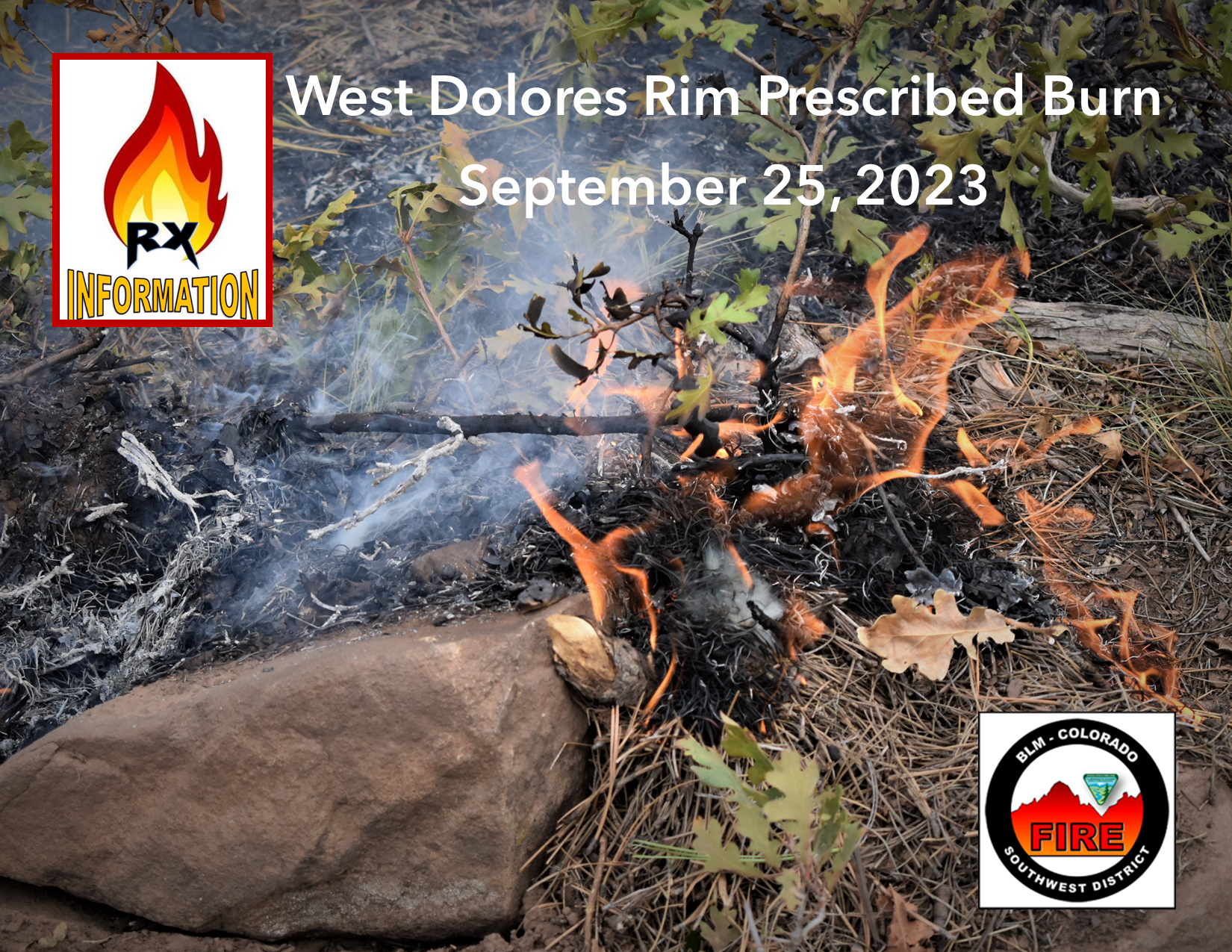
West Dolores Rim prescribed burn resumes Monday September 25 2023
Related Incident:
Publication Type: Announcement
Firefighters on the West Dolores Rim Prescribed Burn have good conditions to resume ignition operations today, Monday, September 25, 2023. They will use drip torches to ignite the perimeter and an unmanned aircraft system (UAS) drone with PSD (plastic sphere dispenser) for aerial ignition in the interior area of the burn unit. Smoke may be visible east of Egnar, CO.
The BLM obtained smoke permits from the Colorado State Air Pollution Control Division, which identify atmospheric conditions under which the burns can be implemented. Prescribed fire smoke may affect your health. For more information, visit https://www.colorado.gov/pacific/cdphe/wood-smoke-and-health.
For more information on BLM Southwest District prescribed burn treatments visit, InciWeb-Southwest District BLM Prescribed Fire https://inciweb.wildfire.gov/ and follow BLM Southwest District Facebook and Twitter @SWD_Fire
Smith River Complex North Daily Update Monday September 25 2023
Related Incident: Smith River Complex
Publication Type: News
Size: 94,508 acres (12,460 ac. in Oregon); Location: Grants Pass, OR; Cause: Lightning
Containment: 85%; Start date: August 15, 2023; Total personnel: 1,199
Resources: 26 crews 6 helicopters 29 engines 8 dozers 17 water tenders 4 masticators 1 Skid Steer
Yesterday: Fire suppression repair and backhauling operations continued on the north end of the fire. Construction progressed on the secondary control line that is situated northwest of the fire along the FS 1106 road. To the southwest of the fire, the other secondary line is now in the final stages of clean-up.
Today’s Activities: Fire managers are monitoring the progress of the weather system that is predicted to be in full force today and lasting into Tuesday. Heavy rains are predicted; flood warnings and a wind advisory will also be in effect. This impending event has implications for the safety of firefighters, contractors, and support staff. Operational contingencies are in place that include directing fire personnel to stand down for safety for up to 24 hours until weather conditions improve. Firefighters remain prepared to respond to natural resource related hazards, such as downed trees, rock falls and mudslides.
Evacuations: The Josephine County Sheriff has set the evacuation status to Level 1-BE READY. Levels will be reevaluated on a recurring basis. This includes the area west of US-199 in Josephine County, including the community of O’Brien and to the Oregon-California border. Monitor the Rogue Valley Emergency Management site and also sign up for evacuation alerts, updates and an interactive Fire First Response Map with evacuation areas here: https://rvem.org/.
Smoke: Southerly to southwest winds will usher smoke northward and inland into Sunday. Smoke from active fires in northern California will contribute to reduced air quality before arrival of rains. The most impacted communities will be along and east of the US-101 corridor of Curry County, inland to Grants Pass and the US-42 corridor. Early smoke in drainages should begin to dissipate by early afternoon. Check current conditions at: https://bit.ly/SWORsmoke
Area Closures: A closure is in place on the Rogue River-Siskiyou National Forest for Forest Road 1106 (South Elk Mountain Road), Forest Road 1205 (Lower Wheeler Road), and Forest Road 1983 (Mt. Emily Road) until October 31, 2023 or until rescinded. The closure allows for safe operations related to the Smith River Complex North. Closures on BLM land are in place as well. Visit bit.ly/RRSNFAlerts or https://www.blm.gov/orwafire for additional information.
Road Closures and Delays: Caltrans in Del Norte County issued a schedule of road closures and lane restrictions on US-199. Weekdays will have a combination of road closure and lane restrictions. Over the weekend, the road will remain open, but with lane restrictions and pilot cars. Expect delays. For specific information on road access, please see the Caltrans QuickMap site https://quickmap.dot.ca.gov/ and Oregon Department of Transportation’s https://www.tripcheck.com/. Local law enforcement cautions against any non-essential traffic along this route. Navigation apps and mapping programs have been routing travelers into active fire areas. Do not use forest roads as alternate routes.
Restrictions: Please respect the temporary flight restriction (TFR) established for the Smith River Complex. Keep drones away from firefighting operations and the TFR. If you fly, we can’t. Don’t be the reason a firefighting air mission has to divert! For more information on the TFR, visit https://tfr.faa.gov/.