
Type 3 Incident Management Team Ordered for Simmons Fire Near Kearny 05 29 2024
Related Incident: Simmons Fire
Publication Type: News
Kearny, AZ (5/29/2024) – More than 100 personnel remain engaged with full suppression efforts on the Simmons Fire burning northwest of Kearny in Pinal County. Cooler overnight temperatures coupled with increased relative humidity levels kept fire activity quiet into the early morning hours. A night shift staffed with a hand crew and engines focused on the east and southeast flanks of the fire, ahead of the community of Kearny. Engine crews also conducted structure protection to properties ahead of the fire.
Today’s weather of wind gusts and shifts, along with hot and dry conditions are a concern for firefighters. The fire is most active throughout the day. Today’s priority for crews is to continue working the east and southeast sides to keep the fire from advancing into Kearny. Structure protection groups will resume efforts to protect nearby homes. For safety reasons, power was shut off to the north Kearny area Tuesday night. Last night two structures were destroyed in the fire. Due to unsafe conditions, fire personnel were unable to conduct a damage assessment.
Fire overhead mapped the fire this morning at 475 acres with no containment. Department of Forestry and Fire Management overhead will fly over the fire today to gather information to better assess fire activity and behavior and view potential fire growth. The Great Basin Incident Management Team will be reassigned from the Rocky Fire on the San Carlos to the Simmons Fire.
Per the Pinal County Sheriff’s Office, residents of the Riverside neighborhood remain on GO – Evacuate status. Residents to the south of the Riverside neighborhood and down to Kearny city limits remain in SET- Be Alert status. Approximately 50 homes are within the SET and GO status. Residents are encouraged to monitor PCSO’s Twitter/X page for updates: https://x.com/PinalCSO. Evacuation status updates will also be sent out through the Pinal Emergency Notification System. To sign up for the alerts visit: https://www.pinal.gov/1335/PENS---Pinal-Emergency-Notification-Syst.
The Arizona Department of Transportation has reopened State Route 177 in both directions. For all road information call 511 or visit: https://x.com/ArizonaDOT.
The Simmons Fire started Tuesday, May 28, around 5:20 p.m., approximately 4.5 miles northwest of Kearny. Tuesday’s winds along with hot and dry conditions played a factor in fast fire growth and extreme fire behavior making it difficult and unsafe for crews to engage in some areas of the fire. The fire is currently burning within the Gila River bottom.
Simmons Fire information can be found at: https://inciweb.wildfire.gov/incident-information/aza4s-simmons-fire.
Indios Fire Daily Update: 05 29 2024
Related Incident: Indios Wildfire
Publication Type: News
Acres: 5,487 Start Date: May 19, 2024
Location: 7 miles north of the village of Coyote,
NM Personnel: 553
Completion: 5%
Fuels: Timber
Highlights: Fire managers have updated their assessment of accomplishments and increased to 5% completion of operational objectives for the Indios Fire. The incident management team will provide an opportunity for the public to meet with fire managers and ask questions about the Indios Fire at an open house on Thursday, May 30, from 6:00 PM to 8:00 PM in the lecture hall at the Coronado High School, 1903 NM-96, Gallina, NM.
Operations: Yesterday, firefighters observed increased fire activity on the western side due to light winds, warmer temperatures, and drier conditions. Aircraft with infrared sensors flew at 16,000 feet above ground level to detect and monitor fire growth to inform firefighting actions. The fire moved south down the interior edge of the fire area while crews worked to strategically apply a low intensity burn ahead of the main fire to prevent southern movement past Forest Road 77. Fire behavior specialists predict the fire will continue to slowly advance through the planned confinement area as the fire naturally aligns with winds and deep canyons. Firefighters are using several helicopters to drop water to cool the fire’s intensity, slow its progress, and reduce smoke impacts. As crews continue working, Resource Advisors are assisting firefighters in identifying and avoiding impacts to sensitive cultural and wildlife resources. To minimize dust impacts to communities, fire engines are applying water to highly traveled dirt roads, including Forest Road 8.
Weather: Humidity increased significantly overnight, however, as temperatures increase later today, conditions are expected to dry out. Along with potential thunderstorm activity over northeastern New Mexico, these conditions are expected to bring increased winds and a 10% chance of precipitation in the fire area today.
Smoke: Smoke from the Indios Fire is visible from surrounding communities. Smoke-sensitive individuals and people with respiratory problems or heart disease are encouraged to take precautionary measures. Learn more about smoke impacts on the New Mexico Environment Department website at https://www.env.nm.gov/air-quality/fire-smoke-links/. An interactive smoke map at https://fire.airnow.gov/ allows you to zoom into your area to see the latest smoke conditions. Daily smoke reports are posted on Inciweb and the social media pages below.
Closures: The Santa Fe National Forest has issued an emergency area closure for the Indios Fire. The purpose of the closure order is to protect public health and safety and the safety of all personnel working on the fire. The full closure order (No. 03-12-05-23-22) and map are available on Inciweb. Camping and water will be available at the Coyote Ranger Station for Continental Divide Trail hikers impacted by this closure.
Safety: The health and safety of firefighters and the public are always the first priority. Members of the public should stay away from Indios Fire operations. A temporary flight restriction (TFR) is in place over the area, which includes uncrewed aircraft systems or drones. More information on the dangers drones pose to wildland firefighting aircraft and personnel on the ground can be found at: https://uas.nifc.gov/.
More Information: inciweb.wildfire.gov/incident-information/nmsnf-indios-wildfire /
575-323-2290 / x.com/SantafeNF / facebook.com/santafeNF / 2024.indios@firenet.gov
Esquibel Prescribed Fire Update 05 29 2024
Related Incident:
Publication Type: News
After a successful shift on Tuesday, fire crews this morning began a third day of ignitions on the Esquibel Prescribed Fire. The most current National Weather Service spot forecast for the area estimates winds of 5 to 10 mph. Fire managers are using a portable remote automatic weather station, as well as two permanent stations nearby, to closely monitor conditions on site.
Yesterday, crew members, including the Forest Stewards Guild All Hands All Lands Burn Team, blacklined most of the southern side of the prescribed fire unit. Blacklining is pre-burning fuels along the control line before interior areas are treated. To date, 776 acres have been treated.
Today, crew members will conduct ignitions off the unit’s east side, which was blacklined on Monday. A helicopter may be used to treat areas further into the interior, likely resulting in larger areas of treatment. Ignitions on the 2,962-acre prescribed fire unit are expected to last throughout the week.
Residents and visitors in the area will likely observe smoke coming from the unit, as well as the Indios Fire on the Santa Fe National Forest. Check the Fire and Smoke Map for local air quality and use the Environmental Protection Agency’s smoke-ready toolbox for protective actions. A limited number of portable air filter units, courtesy of the Forest Stewards Guild, are available on loan for nearby smoke-sensitive residents. Call the Tres Piedras Ranger Station at 575-758-8678 for availability.
Fire crews are targeting fuels on the forest floor, such as leaf litter, downed branches and brush. The fire may fully burn single trees or stands, which will help create an open canopy. They will use recently greened-up grassland areas within the unit as holding features, along with Forest Road 83 and two prescribed fires from 2015 and 2021.
As part of the Rio Chama Collaborative Forest Landscape Restoration Project, prescribed fire in this area contributes to goals of improving and maintaining the health and resiliency of the Rio Chama and Rio Grande watersheds.
Public information officers will continue to post updates on InciWeb, Carson National Forest social media channels (Facebook, X) and New Mexico Fire Information as operations continue.
Smoke Outlook for NorthCentral New Mexico Indios Fire 529 530 05 29 2024
Related Incident: Indios Wildfire
Publication Type: Announcement
Smoke Outlook for Blue 2 Fire Now Available 05 29 2024
Related Incident: Blue 2 Fire
Publication Type: Announcement
The smoke outlook for the Blue 2 Fire is now available at Airfire.gov. https://outlooks.airfire.org/outlook/430b2c05?
A brief change in wind direction overnight, pushed some smoke west, back onto the fire itself. Bonito and Capitan cleared overnight, but will come back to periods of heavy smoke this afternoon as dry conditions and southwest winds return. Carrizozo will maintain overall GOOD air quality, but there is a potential for brief periods of light smoke this evening. Predominate southwest winds should keep smoke north of Ruidoso and hazy conditions this morning should clear by the afternoon. No smoke is expected as far east as Roswell, but the area could see some light haze in the skies in the coming days.
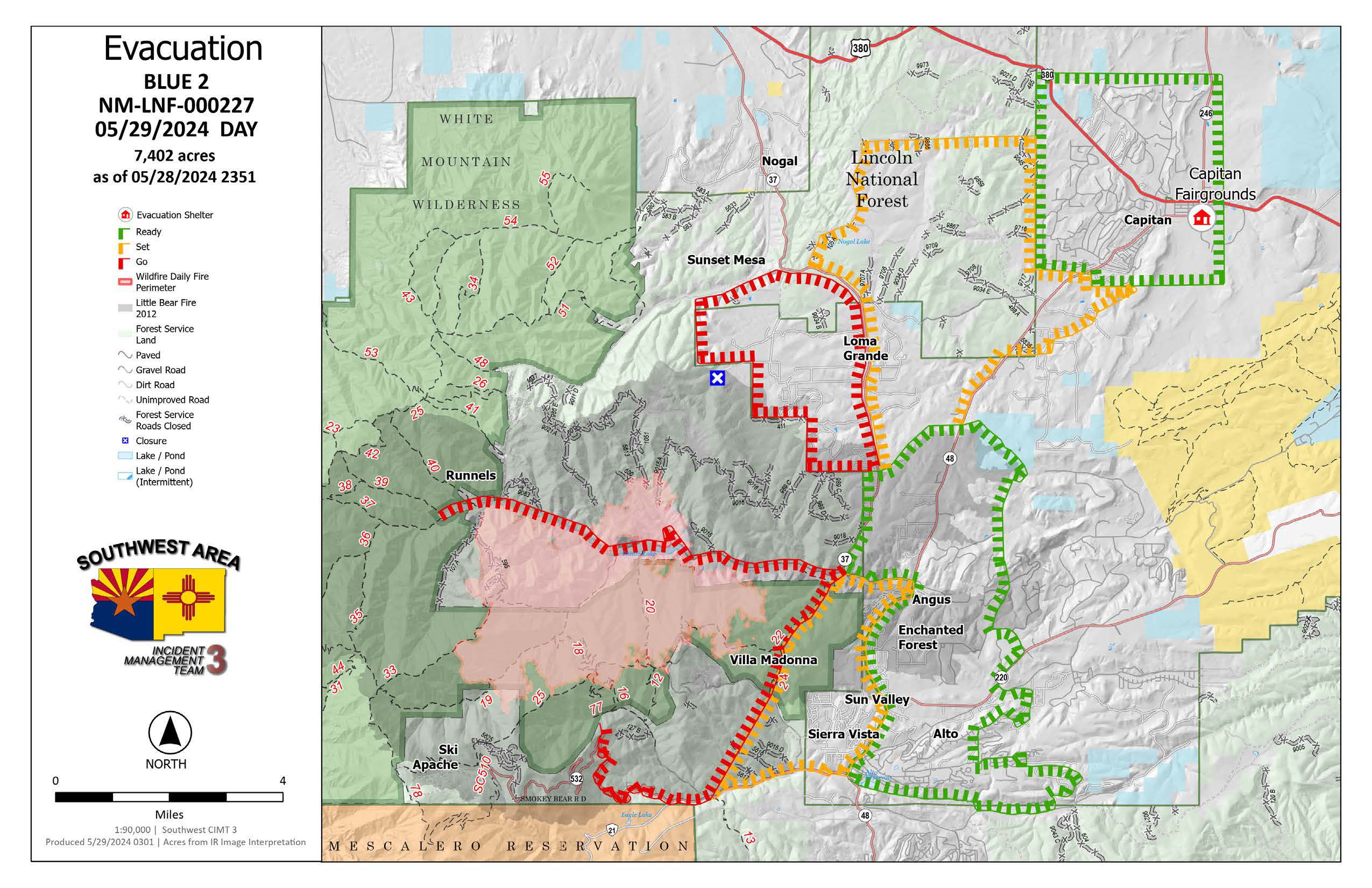
Daily Update: Firefighters Continue to Build Fireline for 100 Percent Suppression Efforts 05 29 2024
Related Incident: Blue 2 Fire
Publication Type: News
Firefighters Continue to Build Fireline for 100 Percent Suppression Efforts
Daily Update: May 29, 2024
Fire Information Phone Number: (575) 386-5077; open from 7 a.m. to 7 p.m.
Media Phone Number: 575-386-5108; open from 7 a.m. to 7 p.m.
Email: 2024.blue2@firenet.gov
Acres:7,402
Start Date: May 16, 2024
Location: White Mountain Wilderness approximately 8 miles North of Ruidoso
Personnel: 643
Cause: Lightning
Containment: 0%
Fuels: Timber (litter and understory)
Resources: 11 crews | 23 engines | 4 helicopters | 2 bulldozers
Highlights: Firefighters continue to use multiple tactics to fully suppress the fire. Hotshots have been igniting fuels by hand near Bonito Creek Campground on the northwest side of the fire to bring the fire safely down to the road. They are also setting up sprinklers near the intersection of Tanbark Canyon road and the 107 road. On Soldier Mountain, hotshots connected handline all the way around the spot that is north of the 107 road and will continue reinforcing this line. Crews are also removing fuels in preparation to build more fireline using bulldozers along the Forest Service boundary. Sprinklers and hoses set up in Villa Madonna are tested daily and supplied with water. Retardant was dropped on the southern side of the fire to allow crews to continuing working along the fire’s edge. On the southwest side of the fire, crews are improving the Crest Trail to use as a holding feature if needed. The public should expect to see smoke across the fire area.
Fire Activity: Smoke will be visible during the day because of active fire burning within the fire area.
Weather: Breezy winds continue with very dry and hot temperatures.
Closures: Lincoln National Forest Alerts and Notices
Evacuations: For the latest information visit the Lincoln County Office of Emergency Services Blue Fire 2 Update page
For Ready, Set, Go Status definitions, please visit Ready, Set, Go! New Mexico

Actualización del día: Los bomberos siguen el esfuerzo de construyendo una línea de fuego para la extinción del 100 del incendio 05 29 2024
Related Incident: Blue 2 Fire
Publication Type: News
Los bomberos siguen el esfuerzo de construyendo una línea de fuego para la extinción del 100% del incendio
Actualización del día: 29 de mayo de 2024
Número de teléfono de información sobre el incendio Blue 2: (575) 386-5077; horas: 7 a.m.-7 p.m.
Número de teléfono del medio: 575-386-5108; horas: 7 a.m.-7 p.m.
Correo electrónico: 2024.blue2@firenet.gov
Acres: 7,402
Fecha de inicio: 16 de Mayo de 2024
Ubicación: White Mountain Wilderness approximately 8 miles North of Ruidoso
Personal total: 643
Causa: Rayo
Combustibles: Arboles, (hojarasca y sotobosque)
Contención: 0%
Recursos: 12 cuadrillas | 38 vehículos de bomberos | 7 helicópteros | 9 buldóceres | 10 licitaciones de agua
Puntos destacados: Los bomberos siguen utilizando múltiples tácticas para suprimir completamente el fuego. Hotshots (bomberos) han estado encendiendo combustibles a mano cerca de Bonito Creek Campground en el lado noroeste del fuego para llevar el fuego con seguridad hasta la carretera. También están instalando aspersores cerca de la intersección de la carretera Tanbark Canyon y la carretera 107. En Soldier Mountain, los equipos de extinción conectaron una línea de mano alrededor del punto que se encuentra al norte de la carretera 107 y continuarán reforzando esta línea. Las cuadrillas también están eliminando combustibles en preparación para construir más línea de fuego utilizando bulldozers a lo largo del límite del Servicio Forestal. Los aspersores y mangueras instalados en Villa Madonna se comprueban diariamente y se les suministra agua. Se lanzó retardante en el lado sur del incendio para permitir a los equipos seguir trabajando a lo largo del borde del incendio. En el lado suroeste del incendio, las cuadrillas están mejorando el Crest Trail para utilizarlo como elemento de contención en caso necesario. El público debe esperar ver humo en toda la zona del incendio.
Actividad del fuego: El humo será visible durante el día debido a la quema activa dentro de la zona del incendio.
El tiempo: Continúan los vientos ventosos con temperaturas muy secas y calurosas
Cierres: https://www.fs.usda.gov/alerts/lincoln/alerts-notices
Evacuaciones: Para más información: https://www.lincolncountynm.gov/news_detail_T2_R25.php
Para las definiciones de estado Ready, Set, Go, please visit: https://www.emnrd.nm.gov/sfd/fire-prevention-programs/ready-set-go-new-mexico/
Settings - change map background and toggle additional layers
Filter - control incident types displayed on map.
Zoom to your location
Reset map zoom and position
Could not determine your location.
Show Legend
 Wildfire
 Prescribed Fire
 Burned Area
Response
Burned Area
Response Other
Other
Simmons Fire
Unit Information
Incident Contacts
Daily Update 05 28 2024
Related Incident: Refuge
Publication Type: News
Incident Management Team Transitioning to Fish and Wildlife Service
Update: Fire crews will continue to monitor and patrol hot spots within the interior of the burned area for days or weeks to come. Crews will also be conducting suppression repair efforts to return the burned area to pre-fire condition as much as possible to maintain critical habitat. The Central West Zone Incident Management Team (CWZT3) will transition all fire resources back to the Fish and Wildlife Service (FWS) on Friday. The fuels involved in the burned area will continue to smolder for weeks due to weather conditions, higher temperatures, wind gusts and lower relative humidities. These conditions will play a part in how long unburned vegetation will need to be monitored. Fire resources will remain on the fire for as long as a threat persists while being under the management of the FWS.
Community Response: Roadways on the Imperial National Wildlife Refuge will remain closed for an undetermined time while firefighters continue monitoring and patrolling hot spots. We are requesting that the public continue to exercise patience during the closure for the safety of themselves and fire crews. There are currently no immediate threats to surrounding communities, infrastructure, or natural resources.
Smoke: Smoke production is very limited, but some smoldering of fuels will produce smoke for weeks to come.
Closures: Red Cloud Mine Road and service roads on the Refuge.
Fire Restrictions: No fires are allowed in Fish and Wildlife Service areas. More information about fire management can be found at: www.fws.gov/program/fire-management.
Location: Imperial National Wildlife Refuge, north of Martinez Lake, Yuma AZ
Start Date: May 25, 2024
Size: Approximately 1,041 Acres
Percent Contained: 61%
Cause: Human Caused, Under Investigation
Vegetation: Salt Cedar and Riparian vegetation
Resources: 2 Crews, 8 Engines, 1 Helicopters, 1 Dozers, 1Water Tender and Additional Support Personnel
Number of Personnel Assigned: 116
For fire information please call (928) 783-3371
InciWeb: InciWeb.gov Refuge Fire
Facebook: Imperial National Wildlife Refuge
Spruce Creek Fire Area and Road Closures Rescinded 05 28 2024
Related Incident:
Publication Type: Closures
The Temporary Closure Order covering the Spruce Creek Fire area has been rescinded. The area is open to the public, but please be careful, and aware that firefighters are still working in the area. Crews continue to secure fireline and mitigate hazards near roads and trails. Pockets of ground fuels within the fire’s interior continue to burn.
Hazards may include stump holes with hot ashes, unstable ground where roots have burned and fire-weakened trees. These hazards are not always obvious to the casual observer so, when in the area, enter at your own risk, and please keep your dogs leashed.