
Rio Arriba County Fire & Emergency Services Community Notification System 05 27 2024
Related Incident: Indios Wildfire
Publication Type: Announcement
Daily Update: 05 27 2024
Related Incident: Indios Wildfire
Publication Type: News
Indios Fire
Acres: 4,210
Start Date: 5/19/2024
Location: 7 miles north of the village of Coyote, NM
Personnel: 292
Containment: 0%
Fuels: Timber
Highlights: The Southwest Area Complex Incident Management Team 4 assumed command of the lightning caused Indios Fire at 7:00 AM this morning, Monday, May 27, 2024. A complex team brings additional resources and management capabilities to manage the Indios Fire. Incident objectives include protecting values at risk and meeting Santa Fe National Forest Plan objectives by reintroducing fire into a fire dependent ecosystem. Expected benefits include reduction of hazardous fuels, encouraging native growth, and improving range and watershed conditions, species diversity, and wildlife habitat.
Operations: Despite windy conditions, the fire has been predominantly driven by topography in steep, rugged terrain in the Chama River Canyon Wilderness. Firefighters continue to construct firelines by removing vegetation along existing roads and tying into natural features, such as rocky cliffs, around the fire area. Crews are strategically applying low intensity fire along Forest Road 77 to remove vegetation between a previous wildfire burned area and the main fire to prevent fire spread to the east. Firefighters have conducted aerial reconnaissance missions and observed beneficial fire effects across the landscape. Fire crews are working to minimize adverse fire impacts to federal and private lands including watersheds, natural and cultural resources, range, and agricultural infrastructure, and preserving landscape characteristics in the Chama River Canyon Wilderness. Additionally, firefighters are working strategically to minimize smoke impacts to communities and critical travel corridors to the extent possible.
Weather: A high pressure system will build over the area over the next few days resulting in increased temperatures and lower humidity. Mid-level clouds will develop over the mountains in the region bringing a slight potential for precipitation in the region by Tuesday or Wednesday.
Smoke: Smoke from the Indios Fire became more visible in the surrounding communities yesterday, including Espanola and Abiquiu. Winds are expected to assist with smoke dispersal this afternoon. Smoke-sensitive individuals and people with respiratory problems or heart disease are encouraged to take precautionary measures. Learn more about smoke impacts on the New Mexico Environment Department website at https://www.env.nm.gov/air-quality/fire-smoke-links/. An interactive smoke map at https://fire.airnow.gov/ allows you to zoom into your area to see the latest smoke conditions.
Closures: The Santa Fe National Forest has issued an emergency area closure for the Indios Fire. The purpose of the closure order is to protect public health and safety and the safety of all personnel working the fire. The full closure order (No. 03-12-05-23-22) and map are available on Inciweb. Camping and water will be available at the Coyote Ranger Station for Continental Divide Trail hikers impacted by this closure.
Safety: The health and safety of firefighters and the public are always the first priority. Members of the public should stay away from Indios Fire operations. A temporary flight restriction (TFR) is in place over the area, which includes uncrewed aircraft or drones. More information on the dangers drones pose to wildland firefighting aircraft and personnel on the ground can be found at: https://uas.nifc.gov/.
More Information: inciweb.wildfire.gov/incident-information/nmsnf-indios-wildfire /
575-323-2290 / x.com/SantafeNF / facebook.com/santafeNF / 2024.indios@firenet.gov
Actualización del día: Los bomberos trabajan en turnos diurnos y nocturnos para sofocar el incendio del Blue 2 05 27 2024
Related Incident: Blue 2 Fire
Publication Type: News
Los bomberos trabajan en turnos diurnos y nocturnos para sofocar el incendio
Actualización del día 27 de mayo de 2024
Número de teléfono de información sobre el incendio Blue 2: (575) 386-5077; horas: 7 a.m.-7 p.m.
Número de teléfono del medio: 575-386-5108; horas: 7 a.m.-7 p.m.
Correo electrónico: 2024.blue2@firenet.gov
Acres: 6,863
Fecha de inicio: 16 de Mayo de 2024
Ubicación: White Mountain Wilderness approximately 8 miles North of Ruidoso
Personal total: 532
Causa: Rayo
Combustibles: Arboles, (hojarasca y sotobosque)
Contención: 0%
Recursos: 11 cuadrillas | 23 vehículos de bomberos | 4 helicópteros | 2 buldóceres
Puntos destacados: Los bomberos trabajan en turnos diurnos y nocturnos para sofocar el incendio. Los bomberos siguen construyendo líneas de fuego con herramientas manuales y buldóceres. Los medios aéreos están lanzando agua y retardante para frenar el avance del incendio y reforzar las líneas de fuego. Durante las operaciones nocturnas, los bomberos están llevando a cabo operaciones de quema para consumir el combustible entre la línea de fuego y el borde del incendio. Esta táctica ayuda a reforzar la línea de fuego y a reducir el movimiento del incendio. Los bomberos han colocado aspersores y mangueras alrededor de las casas para proteger las estructuras.
Actividad del fuego: Aunque el fuego sigue ardiendo durante el día y la noche debido a las altas temperaturas y las condiciones de sequedad, ha tenido poco movimiento.
El tiempo: Vientos persistentes con tendencia cálida y seca durante los próximos días.
Cierres: https://www.fs.usda.gov/alerts/lincoln/alerts-notices
Evacuaciones: Para más información: https://www.lincolncountynm.gov/news_detail_T2_R25.php
Para las definiciones de estado Ready, Set, Go, please visit: https://www.emnrd.nm.gov/sfd/fire-prevention-programs/ready-set-go-new-mexico/
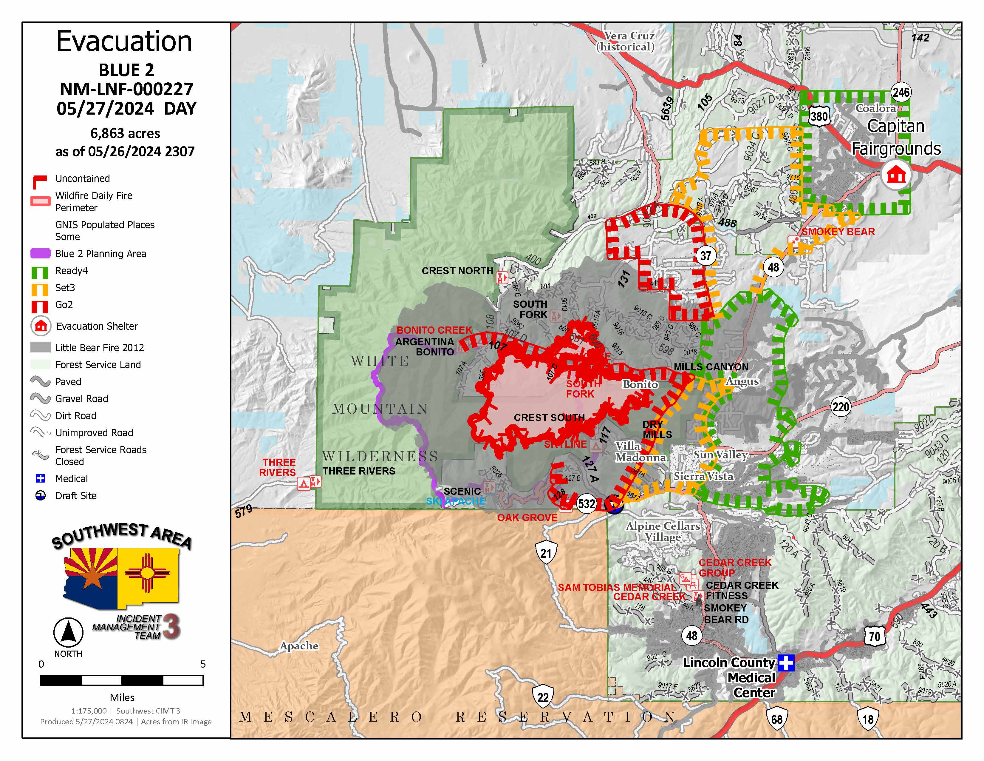
Blue 2 Fire Evacuation Map 05-27
Mon, 05/27/2024 - 14:19
Evacuation map for the Blue 2 Fire for May 27th, 2024. All evacuation status are maintained and updated by the Lincoln County Office of Emergency Services.
Daily Update:Firefighters are Working Day and Night Shifts to Suppress the Blue 2 Fire 05 27 2024
Related Incident: Blue 2 Fire
Publication Type: News
Firefighters are Working Day and Night Shifts to Suppress the Blue 2 Fire
Daily Update: May 27,2024
Fire Information Phone Number: (575) 386-5077; open from 7 a.m. to 7 p.m.
Media Phone Number: 575-386-5108; open from 7 a.m. to 7 p.m.
Email: 2024.blue2@firenet.gov
Acres: 6,863
Start Date: May 16, 2024
Location: White Mountain Wilderness approximately 8 miles North of Ruidoso
Personnel: 532
Cause: Lightning
Containment: 0%
Fuels: Timber (litter and understory)
Resources: 11 crews | 23 engines | 4 helicopters | 2 bulldozers
Highlights: Firefighters are working during day and night shifts to suppress the fire. Firefighters are continuing to build fireline using hand tools and bulldozers. Air resources are dropping water and fire retardant to slow the progress of the fire and re-enforce firelines. During nighttime operations, firefighters are conducting burnout operations to consume the fuel between the fireline and the edge of the fire. This tactic helps to strengthen the fireline and reduce movement of the fire. Firefighters have been placing sprinklers and hoses around houses for structure protection.
Fire Activity: Although the fire continues to burn during the day and night due to high temperatures and dry conditions, it has had little movement.
Weather: Persistent winds with a warming and dry trend over the next few days.
Closures: Lincoln National Forest Alerts and Notices
Evacuations: For the latest information visit the Lincoln County Office of Emergency Services Blue Fire 2 Update page
For Ready, Set, Go Status definitions, please visit Ready, Set, Go! New Mexico
Blue 2 Fire Evacuation Map 05-27
Mon, 05/27/2024 - 14:19
Evacuation map for the Blue 2 Fire for May 27th, 2024. All evacuation status are maintained and updated by the Lincoln County Office of Emergency Services.
Spruce Creek Fire Update 05 27 2024
Related Incident:
Publication Type: News
Fire start date: May 14, 2024
Fire size today: 5,699 acres
Location: 11 miles Northeast of Dolores, CO on Haycamp Mesa
Personnel: 167
Cause: Lightning
Containment: 73%
Evacuation Information:
There are no current evacuations.
Fire Area and Roads Closure:
https://inciweb.wildfire.gov/incident-information/cosjf-2024-spruce-creek-co
Latest Smoke Outlook:
https://fire.airnow.gov/?aqi_v=2&m_ids=&pa_ids=%23
INCIDENT OBJECTIVES:
- Provide for firefighter and public safety throughout all phases of the incident
- Manage hazards to responders and the public using a risk-based approach to decision-making on a continual basis
- Protect critical values at risk
- Reduce the long-term risk to communities from future wildfire events
YESTERDAY’S OPERATIONS:
- Smoke output was minimal, and confined to interior pockets of fuel.
- Firefighters patrolled the outside perimeter of the fire area, clearing brush and other wood debris to further-strengthen firelines.
- Crews completed repairs to roads impacted by firefighting operations.
TODAY’S PLAN:
- Crews will continue patrolling the fire perimeter.
- Smoke may be visible in the area and it may settle into valleys and other low-lying areas, especially at night and in the early morning hours. Wildfire smoke may affect your health. For more information, please go to: https://www.colorado.gov/pacific/cdphe/wood-smoke-and-health
WEATHER:
- High temperatures over the fire area may reach 70 on Monday, as the warming trend continues. Humidity levels will drop down into the teens. Winds will be light and terrain-driven.
Daily Update 05 27 2024
Related Incident: Refuge
Publication Type: News
Central West Zone Type 3 Team (CWZT3) Managing Fire as of 6 p.m. Today
Update: The CWZT3 Team is assuming command of the Refuge Fire as of 6 p.m. today. Local fire resources have been fighting the fire since yesterday and have stopped the forward progression to the north and south. The fire continues to burn to the east. Fire crews are concentrating on minimal threats to properties and communities that are in the fires path. As of today little to no serious risks are being assessed to the following areas: Welton-Mohawk-Electric Power Transmission lines, Bureau of Reclamation (BOR)/Multi Species Conservation Program (MSCP) monitoring and pumping infrastructure, BOR Martinez Lake water gaging station, water and control infrastructure such as culverts and piping, Marine Corps Recreation Center, Private property Red Cloud Mine and Fisher’s Landing Marina and Community. Fire crews will continue to focus on these areas. Additional fire resources will be added as needed to suppress the fire to protect these values at risk.
Community Response: Firefighter and public safety are the first priority while fighting this fire. The public is encouraged to stay out of the areas where firefighters are conducting fire suppression activities.
Smoke: Limited smoke will be visible around the fire and surrounding communities.
Closures: Red Cloud Mine Road and Meers Point Recreation Area.
Fire Restrictions: No fires are allowed on Fish and Wildlife Service areas. More information about fire management can be found at: https://www.fws.gov/program/fire-management.
Location: Imperial National Wildlife Refuge, north of Martinez Lake, Yuma AZ
Start Date: May 25, 2024
Size: Approximately 1,226 Acres
Percent Contained: 20%
Cause: Human Caused, Under Investigation
Vegetation: Salt Cedar and riparian vegetation
Resources: 3 Crews, 7 Engines, 1 Dozer, 2 Helicopters and additional support personnel
Number of Personnel Assigned: 130
For fire information please call (480) 608-2181
InciWeb: Azimr Refuge Information | InciWeb (wildfire.gov)
Facebook: Imperial National Wildlife Refuge
Email Address: 2024.refuge@firenet.gov
Settings - change map background and toggle additional layers
Filter - control incident types displayed on map.
Zoom to your location
Reset map zoom and position
Could not determine your location.
Show Legend
 Wildfire
 Prescribed Fire
 Burned Area
Response
Burned Area
Response Other
Other
Refuge
Unit Information
Incident Contacts
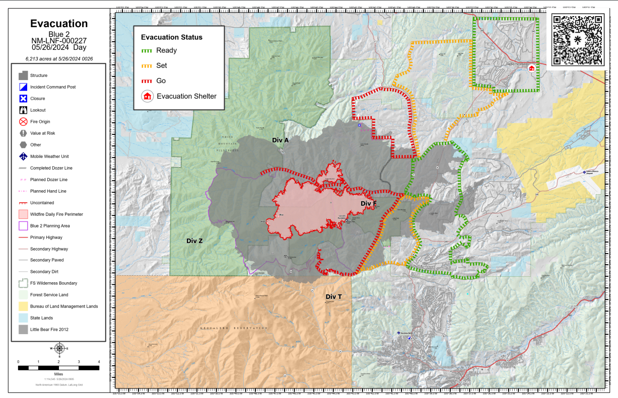
Transition at 6 a.m. to the Complex Incident Management Team 3, Matt Rau, Incident Commander 05 26 2024
Related Incident: Blue 2 Fire
Publication Type: News
Transition at 6 a.m. to the Complex Incident Management Team 3, Matt Rau, Incident Commander
Daily Update: May 26, 2024
Fire Information Phone Number: (575) 386-5077; open from 7 a.m. to 7 p.m.
Media Phone Number: 575-386-9105; open from 7 a.m. to 7 p.m.
Email: 2024.blue2@firenet.gov
Acres: 6,213 Start Date: May 16, 2024
Location: White Mountain Wilderness approximately 8 miles North of Ruidoso
Personnel: 475 Cause: Lightning
Containment: 0% Fuels: Timber (litter and understory)
Resources: 170 personnel | 8 crews | 42 engines | 5 helicopters | 2 bulldozers
Highlights: Additional firefighters have arrived, and more resources are enroute. Firefighters are working along the most active parts of the fire where they can safely engage and are working both during the day and night. Air resources will be used for water and retardant drops on the fire as weather conditions allow.
Fire Activity: The fire has been most active on the northeast and southern perimeters. An acre spot fire was detected in the Dry Mills Canyon and a 100-acre spot fire was detected on Solider mountain.
Weather: Historic wind events are occurring with dry conditions and high temperatures.
Evacuations: For the latest information: https://www.lincolncountynm.gov/news_detail_T2_R25.php
For Ready, Set, Go Status definitions, please visit: https://www.emnrd.nm.gov/sfd/fire-prevention-programs/ready-set-go-new-mexico/

Daily Update: 05 26 2024
Related Incident: Indios Wildfire
Publication Type: News
Facebook Briefing Video
Acres: 2619
Start Date: 5/19/2024
Cause: Lightning
Location: 7 miles north of the village of Coyote, N.M.
Personnel: 204
Containment: 0%
Resources: 6 crews | 1 helicopter | 7 engines| 1 road grader | 2 masticators | 4 water tenders
Highlights: Fire information staff will be posted across the street from Bode’s near the Post Office in Abiquiu on Sunday and Monday (May 26-27) from 12-1 p.m. to meet with members of the public and answer questions.
The Southwest Area Complex Incident Management Team 4, Incident Commander Aaron Hulburd, will assume command of the fire on the morning of Monday, May 27. A CIMT comes with additional resources necessary to plan and manage this fire's long-term duration to meet the intent of letting fire play its natural role on the landscape.
Fire Activity: Despite a Red Flag Warning yesterday and strong winds, the fire showed moderate activity and firelines held. Due to the varied terrain, the fire doesn’t see constant sustained winds, allowing it to play its natural role in the landscape by cleaning up dead and down timber, brush, and needle cast. Because of the steep, rugged terrain, crews continue to build firelines utilizing roads and natural features where it makes sense. The fire continues to have good effects on the landscape as it works towards those lines.
The Carson Interagency Hotshot Crew (IHC) worked at the head of a sub-drainage south of the fire, where they improved the line and held the strategic firing operations they had conducted over the past few days. The Santa Fe and Mount Taylor IHCs made progress working further south towards a chunk of private land within the National Forest boundary. This line is expected to be done in a few more days. The masticators continue working west of the fire, improving along FR 8. The Sandia Helitack is still working at the end of Mesa Gurule toward the private land. The Sacramento and Black Mesa IHCs continue to hold the line on the east side. They will assess additional strategic firing operations with the more favorable weather ahead.
Weather and Smoke: The high temperature will be around 70 degrees, with minimum humidity around 13-17 percent. Winds will be west at 12-17 mph with gusts to 25 mph. Smoke is visible and local communities may experience smoke impacts along Highways 96, 112, and 84. For smoke impacts, visit www.fire.airnow.gov.
Closures: Closure Order 03-10-01-24-02 is in place and includes all National Forest System lands within the boundary of the Coyote Ranger District starting from the Continental Divide trail #298 at Highway 96 going north across Forest Road (FR) 77, through the Chama River Canyon Wilderness to Skull Bridge (Ojitos Trail head) on FR 151. FR 11 northwest to the Chama River Canyon Wilderness boundary and Junction with FR 8; FR 169 (from junction with FR 11) south to FR 473; FR 473 south to FR 64; FR 64 South to the junction of FR 77; and FR 77 east to the Chama River Canyon Wilderness boundary. FR 77 from the Forest boundary and County Road 418 to the junction of FR 64 and FR 77. The Chama River Canyon Wilderness south of Rio Gallina and south of Rio Chama. Visit Inciweb for the full order and map.
For CDT hikers impacted by this closure, camping and water will be available at the Coyote Ranger Station.
Temporary Flight Restrictions: There is a TFR in place around the fire area.
More Information: 575-323-2290 | 2024.indios@firenet.gov | x.com/SantafeNF
facebook.com/santafeNF | inciweb.wildfire.gov/incident-information/nmsnf-indios-wildfire
Spruce Creek Fire Update 05 26 2024
Related Incident:
Publication Type: News
Fire start date: May 14, 2024
Fire size today: 5,699 acres
Location: 11 miles Northeast of Dolores, CO on Haycamp Mesa
Personnel: 173
Cause: Lightning
Containment: 61%
Evacuation Information:
There are no current evacuations.
Fire Area and Roads Closure:
https://inciweb.wildfire.gov/incident-information/cosjf-2024-spruce-creek-co
Latest Smoke Outlook:
https://fire.airnow.gov/?aqi_v=2&m_ids=&pa_ids=%23
INCIDENT OBJECTIVES:
- Provide for firefighter and public safety throughout all phases of the incident
- Manage hazards to responders and the public using a risk-based approach to decision-making on a continual basis
- Protect critical values at risk
- Reduce the long-term risk to communities from future wildfire events
YESTERDAY’S OPERATIONS:
- Fire activity continued to diminish, as interior pockets of ground fuels were consumed, including pine needles, downed logs, stumps and Gambel oak.
- Firefighters patrolled the outside perimeter of the fire area, clearing brush and other wood debris to further-strengthen firelines.
- A dozer and grader made repairs to Forest Service roads in the Haycamp Mesa area that were impacted by firefighting operations.
TODAY’S PLAN:
- Crews will continue patrolling the fire perimeter.
- Repairs continue on roads in the fire area.
- Smoke may be visible in the area and it may settle into valleys and other low-lying areas, especially at night and in the early morning hours. Wildfire smoke may affect your health. For more information, please go to: https://www.colorado.gov/pacific/cdphe/wood-smoke-and-health
WEATHER:
- Sunday starts a warming trend, with high temperatures in the mid-60’s over the fire area. Winds will be moderate and from the northwest, and relative humidity dops to around 20%.