Daily Update: 06 01 2024
Related Incident: Indios Wildfire
Publication Type: News
Firefighters reach 41% completion on the Indios Fire
Daily Update – Saturday, June 1, 2024
Acres: 11,129
Start Date: May 19, 2024
Location: 7 miles north of the village of Coyote, NM
Personnel: 697
Completion: 41%
Fuels: Timber
Highlights: Firefighters successfully applied low intensity fire along Forest Road 77 to prevent fire progression to the south and protect important values, including private property. Fire managers completed a reconnaissance flight over the fire area and observed a mosaic pattern of burned and unburned areas. Large pockets of unburned fuel, referred to as “green islands,” remain within the fire area. Smoke continues to settle in the surrounding communities to the northeast of the fire area.
Operations: Increased cloud cover and higher humidity moderated fire activity yesterday morning. As temperatures increased in the afternoon, crews worked along the northwest edge of the fire to improve and hold the firelines by laying hose and removing snags, while also watching for any spot fires. Crews worked alongside heavy equipment to strengthen and reinforce dozer lines put in place the previous night. In the southwest corner of the fire, crews ignited fuels around the north end of the private property to remove vegetation and create a protective barrier, while others worked to further widen these protection lines. The interior of the fire area burned naturally throughout the day at varying intensities depending on terrain. Multiple aircraft, seven ground crews, and six engines worked together to plan and implement a well-organized burning operation down the Gurule Mesa. Today, crews will continue to reinforce primary and secondary firelines and patrol the perimeter for spot fires. Strategic firing operations conducted by crews on the ground and aircraft will continue across Gurule Mesa to reduce fire intensity and minimize impacts to the watershed.
Weather: Similar temperatures are expected for today, while humidity levels may drop in the afternoon. The chance of precipitation remains at 10%. Winds out of the southwest will move up canyon and likely pick up tomorrow. Warming and drying trends will likely continue over the next week, leading to active fire conditions.
Smoke: Smoke continues to impact surrounding communities. Additional smoke monitors have been installed in Coyote, Gallina, Cañones, and at the Monastery of Christ in the Desert. Smoke-sensitive individuals and people with respiratory problems or heart disease are encouraged to take precautions. A smoke outlook report for the Indios Fire is available online at the links below. View an interactive smoke map at https://fire.airnow.gov/. Learn more about smoke impacts at https://www.env.nm.gov/air-quality/fire-smoke-links/.
Closures: The Santa Fe National Forest has issued a new emergency area closure for the Indios Fire. The full closure order (No. 03-12-05-23-22) and map are available on Inciweb. Camping, water, and shuttle service will be available at the Coyote Ranger Station for Continental Divide Trail hikers impacted by this closure.
Safety: A temporary flight restriction (TFR) is in place over the area, which includes uncrewed aircraft systems or drones. More information on the dangers drones pose to wildland firefighting aircraft and personnel on the ground can be found at: https://uas.nifc.gov/.
inciweb.wildfire.gov/incident-information/nmsnf-indios-wildfire / nmfireinfo.com /
575-323-2290 / x.com/SantafeNF / facebook.com/santafeNF / 2024.indios@firenet.gov
Actualización del día: Los bomberos siguen avanzando en la contención para prepararse ante las meteorológicas pronosticado en el incendio Blue 2 06 01 2024
Related Incident: Blue 2 Fire
Publication Type: News
Los bomberos siguen avanzando en la contención para prepararse ante las meteorológicas pronosticado en el incendio Blue 2
Actualización del día: 1 de junio de 2024
Acres: 7,457 Fecha de inicio: 16 de Mayo de 2024
Ubicación: White Mountain Wilderness aproximadamente a 8 millas al norte de Ruidoso
Personal total:802 Causa: Rayo
Combustibles: Arboles/ Hierba/Arbustos Contención: 14%
Recursos: 17 cuadrillas | 32 vehículos de bomberos | 8 helicópteros | 3 buldóceres | 12 licitaciones de agua
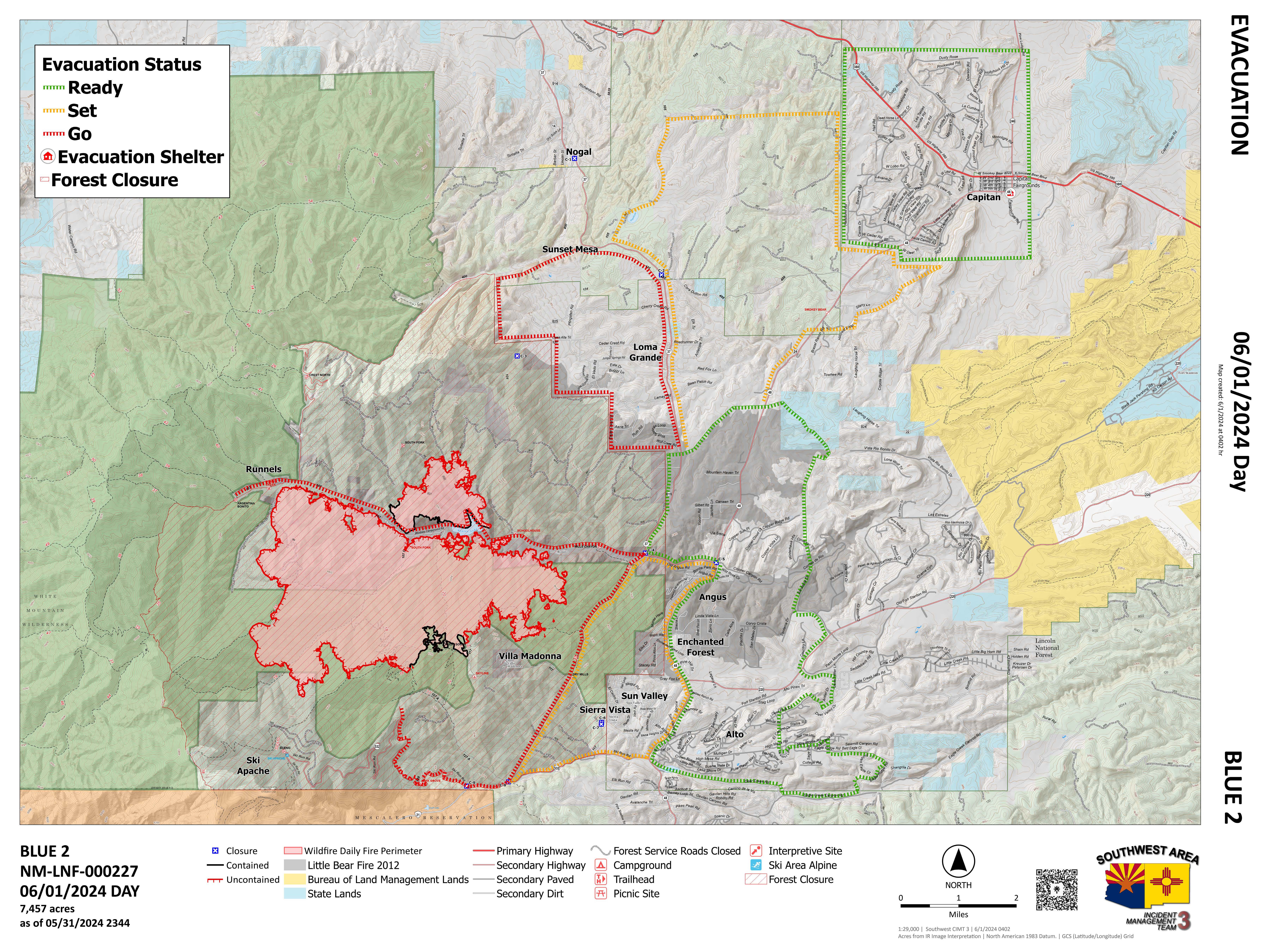
Puntos destacados: Ayer el tiempo fue moderado, lo que ayudó a los bomberos a completar la contención adicional. El extremo sur de Soldier Mountain ganó más línea de contención como el trabajo de limpieza continuó en la zona por los equipos de bomberos sobre el terreno. Se logró una línea de contención adicional en el perímetro del incendio al oeste de Granite Knob. Los bomberos están trabajando duro para poder limpiar a lo largo del borde del fuego para prepararse para el pronóstico de clima cálido y seco a principios de la próxima semana.
Operaciones: Ayer, los equipos de bomberos continuaron limpiando y asegurando las líneas a lo largo de la carretera 107 A y Soldier Mountain. El equipo pesado ha tenido éxito en el progreso de las líneas de contingencia que rodean el fuego. La protección de la estructura tendrá continuamente una presencia a través de las comunidades circundantes en ambos turnos de día y de noche para asegurarse de que las comunidades están siendo monitoreados por cualquier cambio en el fuego. Las labores de limpieza y patrulla continúan en todo el perímetro del incendio. Se están utilizando bombas, aspersores y fuentes de agua para apoyar la protección de las estructuras y los esfuerzos de limpieza. Se sigue avanzando en el límite oriental del bosque, cerca de Enchanted Forest y Sun Valley.
El tiempo: Ayer, la humedad fue alta durante el día hasta última hora de la tarde, lo que ayudó a los bomberos a seguir trabajando con seguridad alrededor del perímetro. Se vieron nubes de tormenta en el borde oriental de la zona del incendio, pero el fuego no recibió humedad. Durante la tarde se produjo un descenso de la humedad debido a los vientos del suroeste que secaron los combustibles finos. Hoy se espera mayor humedad y viento. Nubes de tormenta se verán durante el día alrededor del lado este del incendio. Aunque se espera viento y nubes de tormenta, no se espera un aumento importante del comportamiento del fuego.
Humo: La producción de humo ha disminuido debido a la mínima actividad del incendio. Las tormentas pronosticadas fuera del perímetro del incendio producirán vientos descendentes que podrían desplazar algo de humo ligero a las zonas circundantes. Ver un mapa interactivo de humo en fire.airnow.gov/
Cierres: El Bosque Nacional de Lincoln ha emitido un cierre de emergencia de la zona para el Blue 2 Fire. La orden de cierre (nº 03-08-24-0001) y el mapa están disponibles en Inciweb y en el sitio web del Bosque Nacional de Lincoln.
Evacuaciones: Los niveles de evacuación se mantienen sin cambios. Se espera que los refugios de evacuación permanezcan abiertos durante el fin de semana. Los equipos de bomberos se esfuerzan continuamente por garantizar la seguridad del perímetro del incendio antes de repoblar las comunidades circundantes. Para ver un mapa de evacuación interactivo, visite tinyurl.com/Blue2Evacs
Seguridad: Existe una restricción temporal de vuelo (TFR) sobre la zona, que incluye los sistemas de aeronaves sin tripulación o drones. Encuentre el TFR en tfr.faa.gov/tfr_map_ims/html/
Smoke Outlook for Blue 2 Fire Now Available 06 01 2024
Related Incident: Blue 2 Fire
Publication Type: Announcement
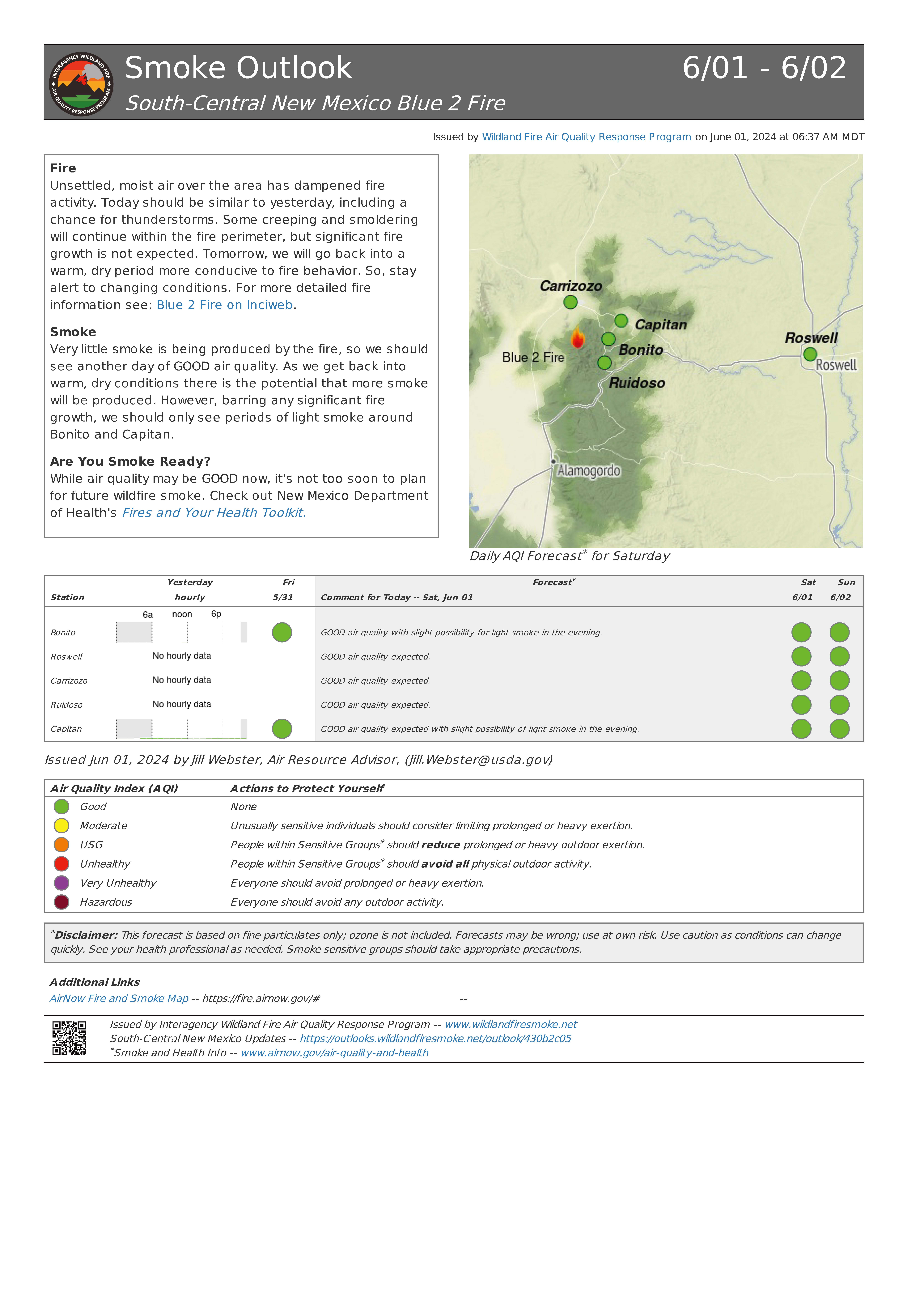
The smoke outlook for the Blue 2 Fire is now available at Airfire.gov. https://outlooks.airfire.org/outlook/430b2c05
Fire
Unsettled, moist air over the area has dampened fire activity. Today should be similar to yesterday, including a chance for thunderstorms. Some creeping and smoldering will continue within the fire perimeter, but significant fire growth is not expected. Tomorrow, we will go back into a warm, dry period more conducive to fire behavior. So, stay alert to changing conditions. For more detailed fire information see: Blue 2 Fire on Inciweb.
Smoke
Very little smoke is being produced by the fire, so we should see another day of GOOD air quality. As we get back into warm, dry conditions there is the potential that more smoke will be produced. However, barring any significant fire growth, we should only see periods of light smoke around Bonito and Capitan.
Daily Update: Firefighters continue containment progress to prepare for forecasted weather on the Blue 2 Fire 06 01 2024
Related Incident: Blue 2 Fire
Publication Type: News
Firefighters continue containment progress to prepare for forecasted weather on the Blue 2 Fire
Daily Update: June 1, 2024
Acres:7,457 Start Date: May 16, 2024
Location: 8 miles North of Ruidoso, White Mountain Wilderness Area Cause: Lightning
Personnel: 802 Fuels: Timber/Grass/Brush
Containment: 14%
Resources: 17 crews | 32 engines | 8 helicopters | 3 bulldozers | 12 Water Tenders
Highlights: Yesterday experienced moderate weather which assisted firefighters in completing additional containment. The southern end of Soldier Mountain gained more containment line as mop up work continued in the area by fire crews on the ground. Additional containment line was achieved on the fire perimeter west of Granite Knob. Firefighters are working hard to be able to mop up along the fire’s edge to prepare for the forecasted hot and dry weather early next week.
Operations: Yesterday, fire crews continued mopping up and securing lines along the 107 A road and Soldier Mountain. Heavy equipment has been successful in progressing the contingency lines that surround the fire. Structure protection will continually have a presence throughout the surrounding communities on both day and night shifts to ensure that communities are being monitored for any changes to the fire. Mop up and patrol continues across the entire fire perimeter. Pumps, sprinklers, and water sources are being used to support structure protection and mop up efforts. Handline on the eastern forest boundary near Enchanted Forest and Sun Valley continue to progress.
Weather: Yesterday, humidity was high during the day until late afternoon which assisted firefighters to continue working safely around the perimeter. Storm clouds were seen at the eastern edge of the fire area, however the fire did not receive any moisture. During the evening there was a drop in humidity due to southwesterly winds that dried out fine fuels. Today, higher humidity and wind is expected. Storm clouds will be seen during the day around the eastern side of the fire. Even though wind and storm clouds are expected, a major increase in fire behavior is not expected.
Smoke: Smoke production has decreased due to minimal fire activity. Thunderstorms predicted outside of the fire perimeter will produce downflow winds that could move some light smoke into surrounding areas. View an interactive smoke map at fire.airnow.gov/
Closures: The Lincoln National Forest has issued an emergency area closure for the Blue 2 Fire. The closure order (No.03-08-24-0001) and map are available on Inciweb and the Lincoln National Forest website.
Evacuations: Evacuation levels remain unchanged. Evacuation shelters are expected to stay open over the weekend. Effort is continually being made by fire crews to ensure that the fire perimeter is safe before repopulation of the surrounding communities. For an interactive evacuation map go to tinyurl.com/Blue2Evacs
Safety: A Temporary Flight Restriction (TFR) is in place over the area, which includes uncrewed aircraft systems or drones. Find the TFR at tfr.faa.gov/tfr_map_ims/html/
Esquibel Prescribed Fire Update 05 31 2024
Related Incident:
Publication Type: News
Fire crews are back on the Esquibel Prescribed Fire for their last day of ignitions. They will focus on using fire to clean-up fuels on the unit’s boundary while interior areas continue to burn for previous days of ignitions. This will be the last daily operational update for the project, but crews will continue to patrol and monitor the unit until the fire is called out.
Winds are expected to be 5 mph in the morning, transitioning to 10-15 mph in the afternoon, according to the latest National Weather Service spot forecast. Fire managers are also using a portable remote automatic weather station, as well as two permanent stations nearby, to closely monitor conditions on site.
Yesterday, crew members, including the Forest Stewards Guild All Hands All Lands Burn Team, focused on interior areas and cleanup of previous work within the Esquibel Unit. To date, 2,476 acres have been treated.
Residents and visitors in the area may observe smoke coming from the unit, as well as the Indios Fire on the Santa Fe National Forest. Check the Fire and Smoke Map for local air quality and use the Environmental Protection Agency’s smoke-ready toolbox for protective actions. A limited number of indoor air filter units, courtesy of the Forest Stewards Guild, are available on loan for nearby smoke-sensitive residents. Call the Tres Piedras Ranger Station at 575-758-8678 for availability.
Fire crews are targeting fuels on the forest floor, such as leaf litter, downed branches and brush. The fire may fully burn single trees or stands, which will help create an open canopy. They are using recently greened-up grassland areas within the unit as holding features, along with Forest Road 83 and two prescribed fires from 2015 and 2021.
Spring burning ecologically mimics historical fire behavior. Most fires would naturally have started during pre-monsoon seasons and burned through the summer until rains put them out. Spring burning helps give plant and tree species the best opportunity to bounce back after a disturbance. For grasses and shrubs, the fire kills the tops, but the roots are still intact because of wetter soil. The fire introduces ash, which has elements and natural chemicals that act like fertilizers. The first rainstorm of the monsoon season will mix with that fertilizer and prompt new growth.
Public information officers will continue to post updates on InciWeb, Carson National Forest social media channels (Facebook, X) and New Mexico Fire Information as operations continue.
Daily Update: 05 31 2024
Related Incident: Indios Wildfire
Publication Type: News
Fire activity increases within planned fire perimeter
Daily Update – Friday, May 31, 2024
Acres: 8,733
Start Date: May 19, 2024
Location: 7 miles north of the village of Coyote, NM
Personnel: 659
Completion: 25%
Fuels: Timber
Highlights: Active fire behavior within the planned fire perimeter led to a visible plume of smoke over the fire area. Large air tankers supported the work of ground crews to slow fire spread on the west side. Last night, an open house was held at the Coronado High School, providing fire information to over 50 community members.
Operations: The fire grew by about 2,500 acres yesterday, starting on the western-most edge of the fire perimeter. Thermal winds influenced fire growth near Forest Road (FR) 64, pushing it to connect into the eastern portion of the fire overnight. Large air tankers dropped retardant in support of the crews as they worked into the evening with bulldozers to help protect private land and stop fire spread across FR 64. Throughout the day, crews masticated along contingency lines to the west of the fire and cleared cut vegetation along FR 8. Fire activity remained within the eastern boundary of the fire, and crews worked to identify and prepare secondary firelines outside of that area. Along the southern tip of the fire, aerial ignition efforts moved the fire north away from FR 77. As fire activity increased, crews in the south focused on community preparedness. Helicopters delivered 64 loads of water over the fire and will likely maintain the same pace today. Firefighters will continue to prepare secondary, contingency firelines outside the planned primary firelines. Aviation activity will remain high to support firefighters on the ground.
Weather: Humidity levels and temperatures should rise slightly today. The chance of precipitation remains at 10%. Warming and drying trends will likely continue over the next week, leading to active fire conditions.
Smoke: A highly visible smoke column could be seen from Santa Fe and across the Rio Grande Valley. Heaviest smoke impacts were overnight into mid-morning hours along low-lying areas from Rio Chamas down to Hernandez. Areas along Highway 96 will have higher smoke levels where elevation is lower. Additional smoke monitors were installed yesterday in Coyote and more are planned for installation in Gallina, Española, Cañones, Chamas, and at the Monastery of Christ in the Desert. Smoke-sensitive individuals and people with respiratory problems or heart disease are encouraged to take precautionary measures. A smoke outlook report for the Indios Fire is available online at the links below. View an interactive smoke map at https://fire.airnow.gov/. Learn more about smoke impacts at https://www.env.nm.gov/air-quality/fire-smoke-links/.
Closures: The Santa Fe National Forest has issued a new emergency area closure for the Indios Fire. The full closure order (No. 03-12-05-23-22) and map are available on Inciweb. Camping, water, and shuttle service will be available at the Coyote Ranger Station for Continental Divide Trail hikers impacted by this closure.
Safety: A temporary flight restriction (TFR) is in place over the area, which includes uncrewed aircraft systems or drones. More information on the dangers drones pose to wildland firefighting aircraft and personnel on the ground can be found at: https://uas.nifc.gov/.
inciweb.wildfire.gov/incident-information/nmsnf-indios-wildfire / nmfireinfo.com /
575-323-2290 / x.com/SantafeNF / facebook.com/santafeNF / 2024.indios@firenet.gov
Smoke Outlook for Blue 2 Fire Now Available 05 31 2024
Related Incident: Blue 2 Fire
Publication Type: Announcement
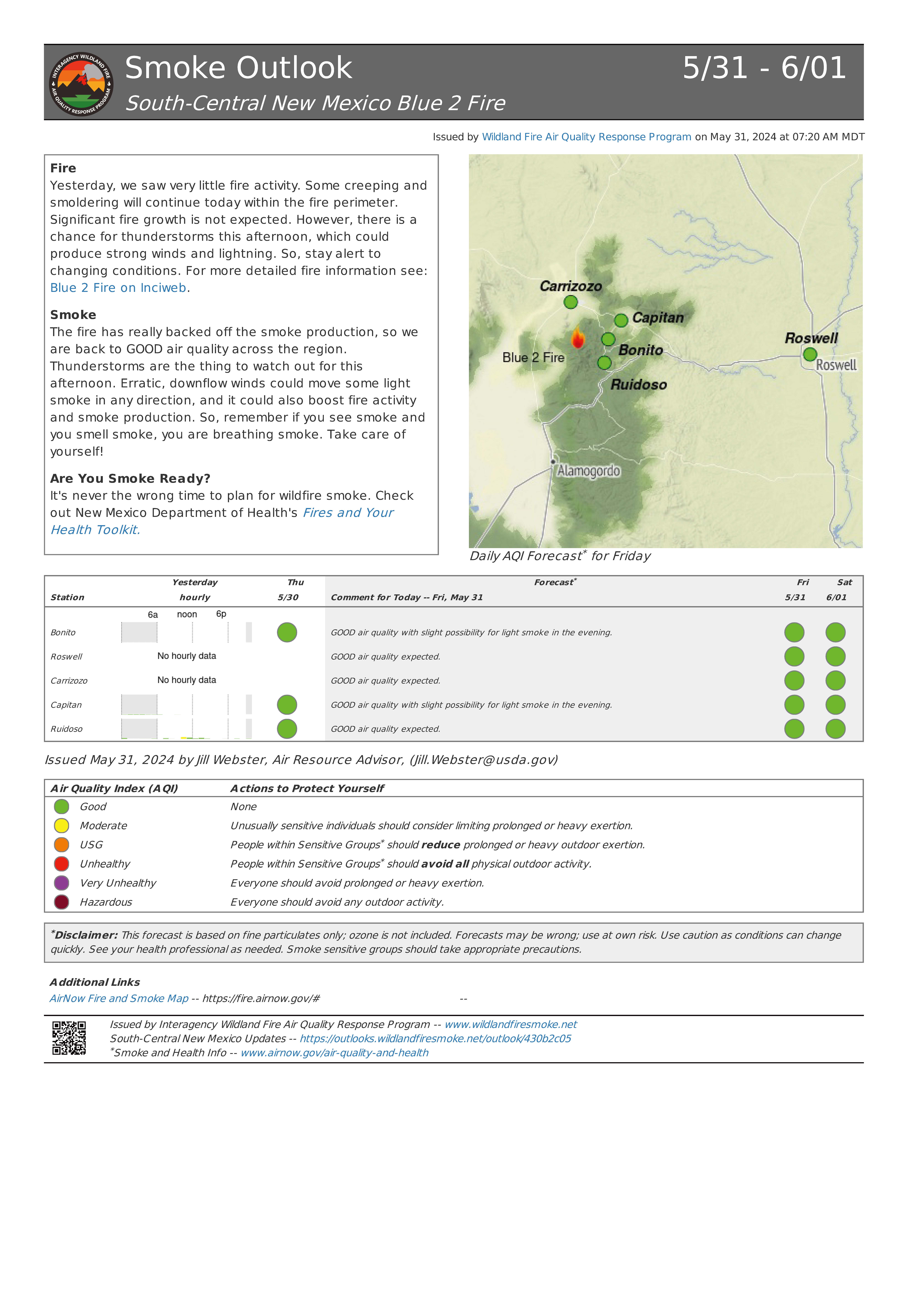
The smoke outlook for the Blue 2 Fire is now available at Airfire.gov. https://outlooks.airfire.org/outlook/430b2c05?
Fire Yesterday, we saw very little fire activity. Some creeping and smoldering will continue today within the fire perimeter. Significant fire growth is not expected. However, there is a chance for thunderstorms this afternoon, which could produce strong winds and lightning. So, stay alert to changing conditions. For more detailed fire information see: Blue 2 Fire on Inciweb.
The fire has really backed off the smoke production, so we are back to GOOD air quality across the region. Thunderstorms are the thing to watch out for this afternoon. Erratic, downflow winds could move some light smoke in any direction, and it could also boost fire activity and smoke production. So, remember if you see smoke and you smell smoke, you are breathing smoke. Take care of yourself!
SET AND GO STATUSES LIFTED FOR RESIDENTS IMPACTED BY WILDFIRE NEAR KEARNY 05 31 2024
Related Incident: Simmons Fire
Publication Type: News
Kearny, AZ (5/31/2024) – As of Friday, May 31, the Pinal County Sheriff’s Office returns all residents impacted by the Simmons Fire back to Ready status. Due to the hard work of firefighters and significant containment within the last 24 hours, incident management and PCSO determined it was safe to lift the GO and SET statuses to residents within the Riverside and Kearny-areas. All residents may return home at this time. Power to the north end of Kearny was restored Thursday night.
Crews continue to work on the fire boundary today moving toward full suppression by securing the 351-acre perimeter. Last night crews were able to get black line around the fire along the east and southeast sides, one of the priority areas for fire overhead. Crews also have containment line along the west flank. Containment currently sits at 51%. More than 157 personnel are engaged working on interior hot spots at the north end of the fire. Remaining resources include, Type 2 hand crews, engines, water tenders and a dozer. A temporary flight restriction remains in place. The Type 3 Incident Management Team will be transitioning the fire over back to the Arizona Department of Forestry and Fire Management tomorrow.
The Simmons Fire started Tuesday, May 28, approximately 4.5 miles northwest of Kearny in Pinal County.
Simmons Fire informational updates can be found at: https://inciweb.wildfire.gov/incident-information/aza4ssimmonsfire. For more information contact: Julie Clark 707-616-8291 or email Julie.clark3@usda.gov or Tiffany Davila at 602-5401036 or email at tdavila@dffm.az.gov.
Smoke Outlook for North Central New Mexico Indios Fire 5312024 and 612024 05 31 2024
Related Incident: Indios Wildfire
Publication Type: Announcement
Actualización del día: Se ha añadido contención al Incendio Blue 2 05 31 2024
Related Incident: Blue 2 Fire
Publication Type: News
Se ha añadido contención al Incendio Blue 2
Actualización del día: 31 de mayo de 2024
Acres: 7,457 Fecha de inicio: 16 de Mayo de 2024
Ubicación: White Mountain Wilderness aproximadamente a 8 millas al norte de Ruidoso
Personal total:785 Causa: Rayo
Combustibles: Arboles/ Hierba/Arbustos Contención: 5%
Recursos: 17 cuadrillas | 31 vehículos de bomberos | 8 helicópteros | 9 buldóceres | 12 licitaciones de agua
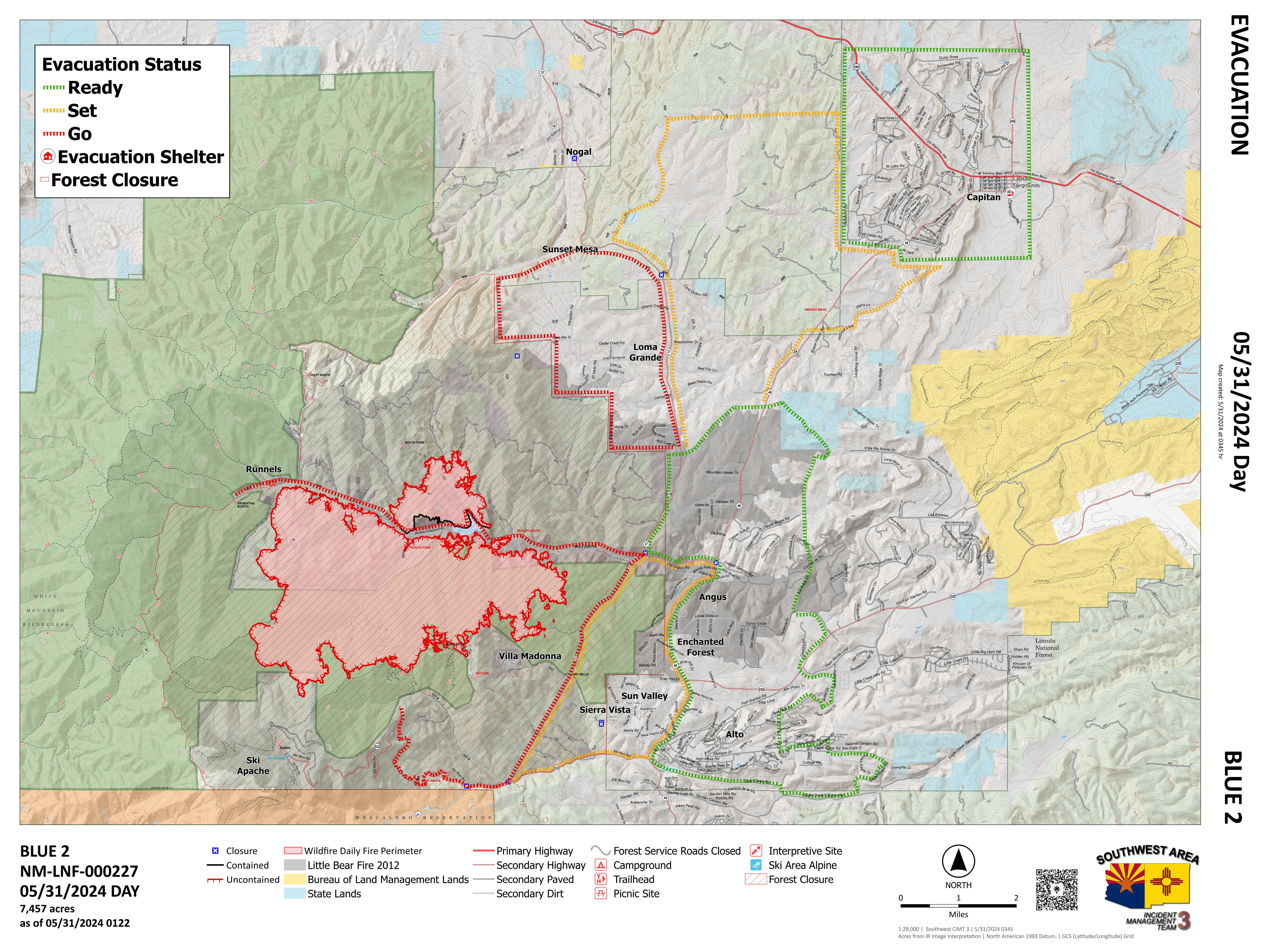
Puntos destacados: Los bomberos lograron una contención del 5% en el lado sur de la Montaña del Soldado. Los equipos de tierra están siendo apoyados por los recursos aéreos para hacer frente a las zonas de calor cerca del borde del incendio. El cierre de la carretera estatal 37 desde la carretera estatal 48 hasta la ruta 380 de EE.UU. fue levantado por la policía de Nuevo México alrededor de las 12:30 pm de ayer. El nivel de peligro de incendio también se ha incrementado a "Muy Alto" y la Etapa 2 de Restricciones de Incendios se han aplicado por funcionarios del Servicio Forestal.
Operaciones: El personal de protección de estructuras continúa trabajando en la instalación de bombas y aspersores para las comunidades al este del límite del Servicio Forestal. La protección de las estructuras del lago Bonito se ha completado, pero se seguirá patrullando. Los equipos de bomberos trabajaron ayer con helicópteros alrededor de Monjeau Peak para extinguir con éxito los puntos calientes. Se están utilizando equipos pesados a lo largo del límite forestal, así como en la sección norte del incendio para asegurarse de que las comunidades tienen una línea secundaria segura en su lugar.
Humo: Se espera que los vientos se mantengan moderados lo que ayudará a un crecimiento mínimo del fuego o la producción de humo. Gran parte del humo que había sido persistente alrededor de las zonas más cercanas al fuego se aclaró. Las áreas que habían estado experimentando períodos de humo pesado, como Bonito y Capitán, pueden esperar BUENA calidad del aire. Existe la posibilidad de períodos de humo ligero esta tarde y noche, pero las condiciones generales deben ser mucho mejor. Ver un mapa interactivo de humo en fire.airnow.gov/
Cierres: El Bosque Nacional de Lincoln ha emitido un cierre de emergencia de la zona para el Blue 2 Fire. La orden de cierre completo (No.03-08-24-0001) y el mapa están disponibles en Inciweb y el sitio web de Lincoln NF.
Evacuaciones: No ha habido cambios recientes en los niveles de evacuación. Los Servicios de Emergencia del Condado de Lincoln han estado trabajando diariamente con el equipo de gestión de incidentes para evaluar el estado de todos los niveles de evacuación. Los equipos de bomberos se están esforzando para garantizar que el perímetro del incendio sea seguro antes de repoblar las comunidades circundantes. Para un mapa interactivo de evacuación ir a tinyurl.com/Blue2Evacs
Seguridad: Existe una restricción temporal de vuelo (TFR) sobre la zona, que incluye los sistemas de aeronaves sin tripulación o drones. Encuentre el TFR en tfr.faa.gov/tfr_map_ims/html/
Teléfono: 575-386-5077(7 a.m. -7 p.m.) Teléfono para medios de comunicación: 575-386-5108(7 a.m.- 7 p.m.)
Inciweb: tinyurl.com/Blue2Fire Correo electrónico: 2024.blue2@firenet.gov
Para más información, consulte el código QR o https://linktr.ee/bluefire.2024

 InciWeb


