Smoke Outlook for NorthCentral New Mexico Indios Fire 06 02 2024
Related Incident: Indios Wildfire
Publication Type: Announcement
Actualización del día:Los bomberos se preparan para que los vientos prueben la línea de fuego en el incendio Blue 2 06 02 2024
Related Incident: Blue 2 Fire
Publication Type: News
Los bomberos se preparan para que los vientos prueben la línea de fuego en el incendio Blue 2
Actualización del día: 2 de junio de 2024
Acres: 7,457 Fecha de inicio: 16 de Mayo de 2024
Ubicación: White Mountain Wilderness aproximadamente a 8 millas al norte de Ruidoso
Personal total: 786 Causa: Rayo
Combustibles: Arboles/ Hierba/Arbustos Contención: 54%
Recursos: 17 cuadrillas | 33 vehículos de bomberos | 8 helicópteros | 6 buldóceres | 10 licitaciones de agua
Puntos destacados: Las tormentas continuarán en las áreas circundantes, causando vientos de salida de hasta 35 mph en las cimas de las crestas que afectarán a la zona del incendio durante todo el día. Los bomberos están preparados para que las condiciones meteorológicas pongan a prueba la contención y la línea abierta restante del perímetro del incendio. El éxito de los trabajos sobre el terreno ha permitido la progresión de una mayor contención.
Operaciones: Ayer, Solider Mountain ha sido totalmente contenida y los bomberos permanecerán en la zona para garantizar que la línea de fuego se mantiene. Los equipos de tierra se centraron en los esfuerzos de limpieza, utilizando agua y herramientas de mano para poder trabajar en la línea no contenida. La protección de las estructuras está en curso y las bombas se prueban continuamente para garantizar que estén plenamente operativas en caso de que se necesiten. El equipo pesado está trabajando en la finalización de la línea de contingencia hacia Buck Mountain. El turno de noche seguirá patrullando alrededor de las comunidades y vigilando cualquier nueva fuente de calor. Hoy, los equipos de tierra se mantendrán vigilantes en previsión de los vientos pronosticados, donde los puntos calientes o las manchas podrían poner a prueba el perímetro del incendio. Los motores estarán cerca del lago Bonito limpiando y proporcionando protección de estructuras a los valores en riesgo. Las cuadrillas están eliminando la tala de las líneas de fuego y el equipo pesado se está utilizando al oeste de Angus y las comunidades del Bosque Encantado para asegurar que las líneas se mantienen seguros.
El tiempo: Debido a la formación de tormentas con truenos y relámpagos en los alrededores, la zona del incendio experimentará vientos que pondrán a prueba el perímetro del incendio con vientos más fuertes procedentes de direcciones diferentes a las que se han experimentado durante los días anteriores. A medida que las tormentas se alejen hacia el este, darán paso a un tiempo seco y caluroso durante los próximos días.
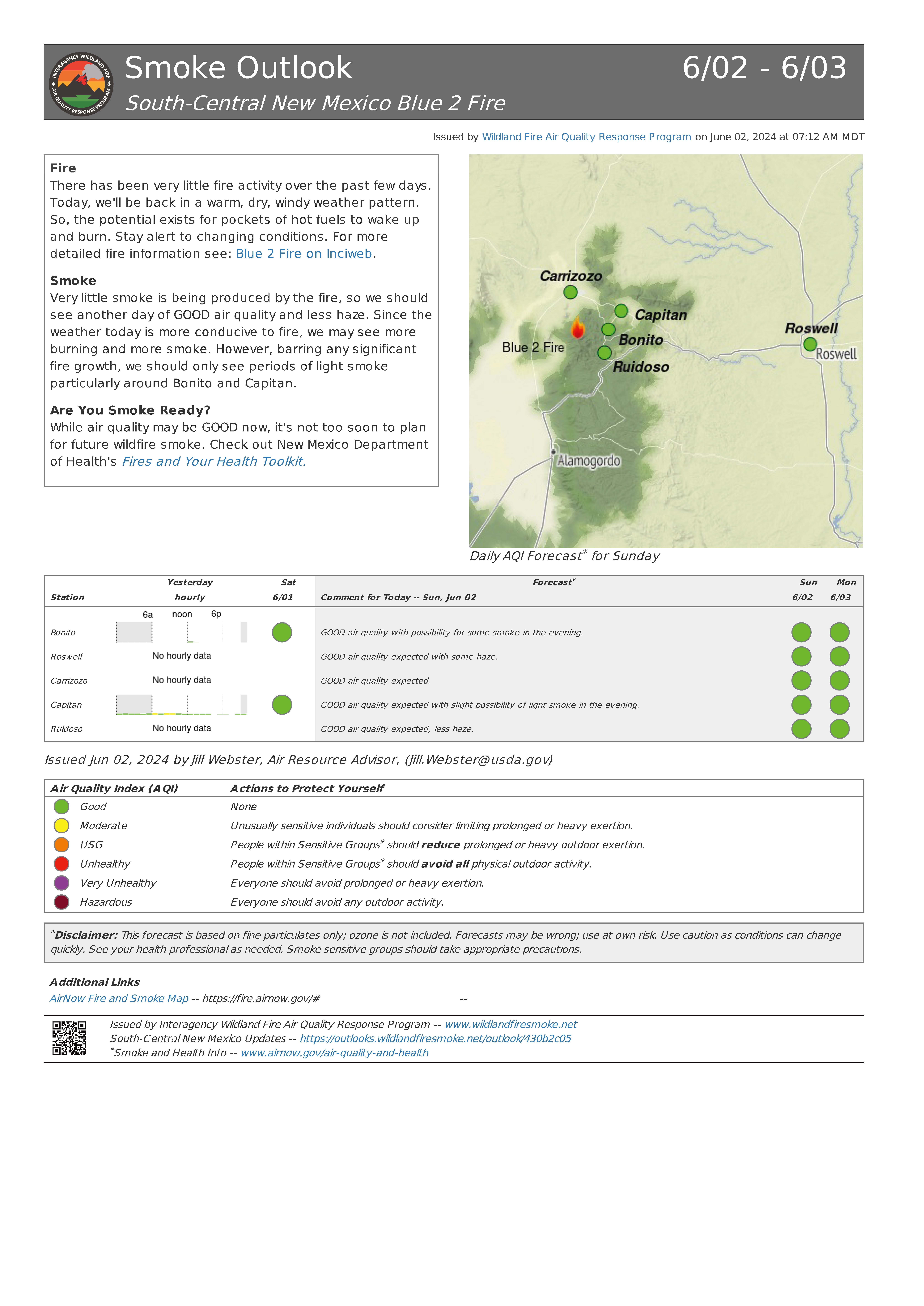
Humo: A medida que se experimenten condiciones cálidas y secas, existe la posibilidad de que se produzca más humo. Sin embargo, salvo que se produzca un crecimiento significativo del fuego, sólo deberían verse periodos de humo ligero alrededor de Bonito y Capitán. Ver un mapa interactivo de humo fire.airnow.gov/
Cierres: El Bosque Nacional de Lincoln ha emitido un cierre de emergencia de la zona para el Blue 2 Fire. La orden de cierre (nº 03-08-24-0001) y el mapa están disponibles en Inciweb y en el sitio web del Bosque Nacional de Lincoln.
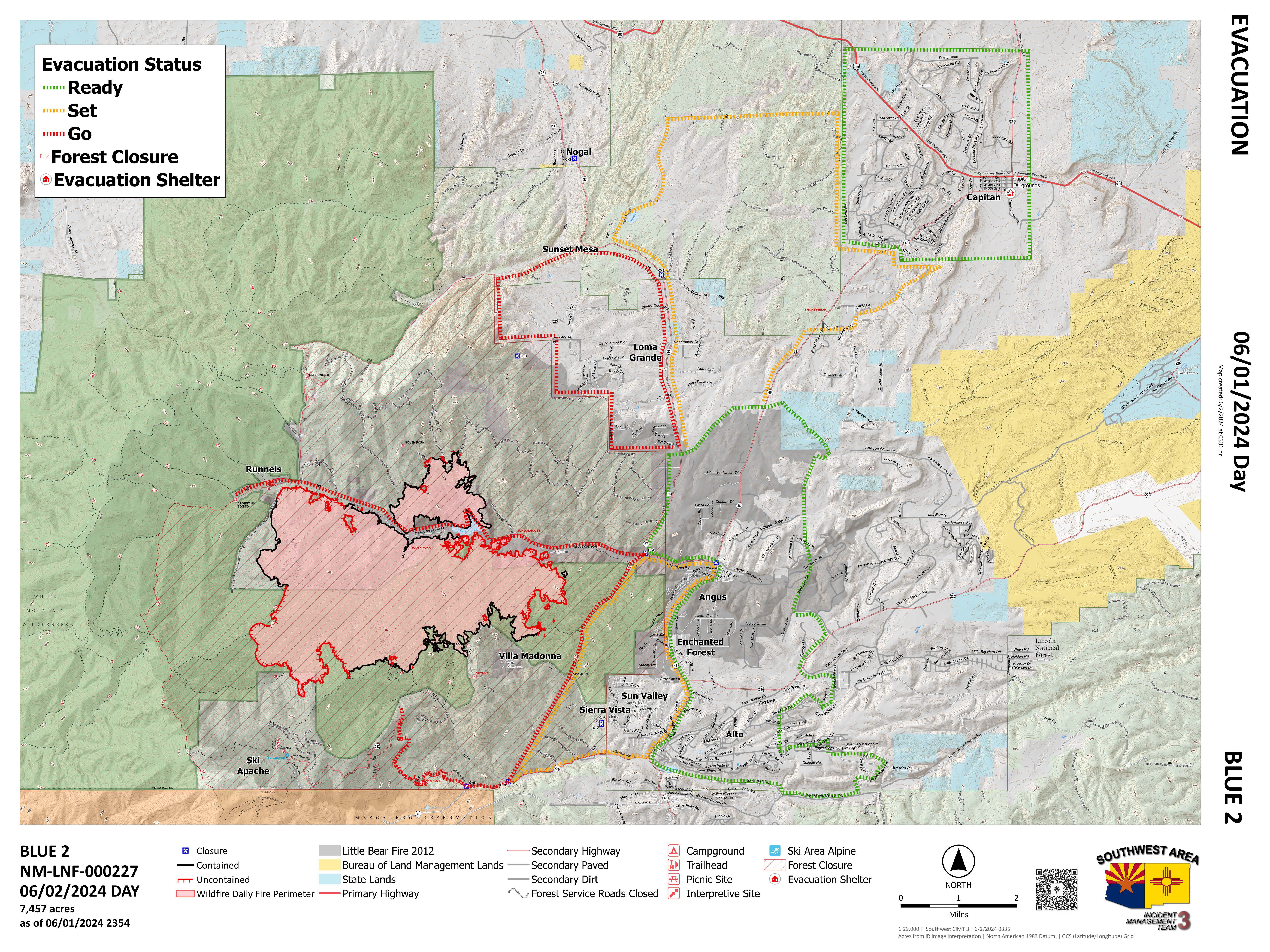
Evacuaciones: Los niveles de evacuación se mantienen sin cambios y el tiempo determinará el estado de las evacuaciones a medida que los gestores evalúen las condiciones actuales. Para ver un mapa de evacuación interactivo, visite tinyurl.com/Blue2Evacs
Seguridad: Sobre la zona hay una Restricción Temporal de Vuelo (TFR), que incluye los sistemas de aeronaves sin tripulación o drones. Encuentre el TFR en tfr.faa.gov/tfr_map_ims/html/
Daily Update: Firefighters prepare for winds to test the fire line on the Blue 2 Fire 06 02 2024
Related Incident: Blue 2 Fire
Publication Type: News
Firefighters prepare for winds to test the fire line on the Blue 2 Fire
Daily Update: June 2, 2024
Acres: 7,457 Start Date: May 16, 2024
Location: 8 miles North of Ruidoso, White Mountain Wilderness Area Cause: Lightning
Personnel: 786 Fuels: Timber/Grass/Brush
Containment: 54%
Resources: 17 crews | 33 engines | 8 helicopters | 6 bulldozers | 10 Water Tenders
Highlights: Storms will continue in the surrounding areas, causing outflow winds up to 35 mph on the ridge tops to affect the fire area throughout the day. Firefighters are prepared for the weather to test the containment and remaining open line of the fire perimeter. Successful work on the ground has allowed the progression of increased containment.
Operations: Yesterday, Solider Mountain has been fully contained and firefighters will remain in the area to ensure that the fireline holds. Ground crews focused on mop up efforts, using water and hand tools to be able to work on the uncontained line. Structure protection is ongoing, and pumps are continually tested to ensure that they are fully operational in the event they are needed. Heavy equipment is working on completion of the contingency line towards Buck Mountain. Night shift will continue to patrol around communities and monitor for any new sources of heat. Today, ground crews will stay vigilant in anticipation of forecasted winds where hotspots or spotting could test the fire perimeter. Engines will be near Bonito Lake mopping up and providing structure protection to values at risk. Crews are removing slash from fire lines and heavy equipment is being used to the west of Angus and the Enchanted Forest communities to ensure that the lines hold.
Weather: Due to the thunderstorm formation in the surrounding areas, the fire area will experience winds that will test the fire perimeter with stronger winds coming from different directions than have been experienced during previous days. As the storms exit to the east, they will give way to dry and hot weather for the next several days.
Smoke: As warm and dry conditions are experienced there is potential for more smoke. However, barring any significant fire growth, only periods of light smoke should be seen around Bonito and Capitan. View an interactive smoke map at fire.airnow.gov/
Closures: The Lincoln National Forest has issued an emergency area closure for the Blue 2 Fire. The closure order (No.03-08-24-0001) and map are available on Inciweb and the Lincoln National Forest website.
Evacuations: Evacuation levels remain unchanged and weather will determine the status of evacuations as managers assess current conditions. For an interactive evacuation map go to tinyurl.com/Blue2Evacs
Safety: A Temporary Flight Restriction (TFR) is in place over the area, which includes uncrewed aircraft systems or drones. Find the TFR at tfr.faa.gov/tfr_map_ims/html/
Smoke Outlook for Blue 2 Fire Now Available 06 02 2024
Related Incident: Blue 2 Fire
Publication Type: Announcement
The smoke outlook for the Blue 2 Fire is now available at Airfire.gov. https://outlooks.airfire.org/outlook/430b2c05
Fire
There has been very little fire activity over the past few days. Today, we'll be back in a warm, dry, windy weather pattern. So, the potential exists for pockets of hot fuels to wake up and burn. Stay alert to changing conditions. For more detailed fire information see: Blue 2 Fire on Inciweb.
Smoke
Very little smoke is being produced by the fire, so we should see another day of GOOD air quality and less haze. Since the weather today is more conducive to fire, we may see more burning and more smoke. However, barring any significant fire growth, we should only see periods of light smoke particularly around Bonito and Capitan.
Are You Smoke Ready?
While air quality may be GOOD now, it's not too soon to plan for future wildfire smoke. Check out New Mexico Department of Health's Fires and Your Health Toolkit.
Could not determine your location.
Spring Fire
Unit Information
Incident Contacts
Simmons Fire Winding Down as Containment Reaches 85% 06 01 2024
Related Incident: Simmons Fire
Publication Type: News
Kearny, AZ (6/1/2024) – For the second night in a row the Simmons Fire stayed with its footprint with no new growth being reported. The fire is 351 acres and 85% contained.
Today, remaining resources, including a hand crew and engines continue to cold trail the fire’s edge checking for any remaining heat along the fire line. Heavy and downed fuels continue to smolder within the fire’s interior and engines remain engaged patrolling and monitoring the perimeter for the possibility of lingering heat or smokes. Over the last few days, wildland fire resources have been aggressively working to protect the community of Kearny, critical infrastructure, including gas and utility lines, along with structures within the vicinity of the fire.
On Friday, and in coordination with the Type 3 Incident Management Team, the Pinal County Sheriff’s Office lifted the SET and GO statuses to residents impacted by the fire. All residents remain in Ready. As activity continues to increase, Arizonans are urged to sign up for emergency alerts with their county emergency management office. Be ready with a ‘go bag’ to include, personal items, important papers, prescriptions, water and snacks. In the event of a GO – evacuation, always remember to take your pets.
This morning, the Nevada Type 3 Incident Management Team transitioned management of the fire back to the Arizona Department of Forestry and Fire Management as a Type 4 incident. A Type 4 incident is one of a lower complexity.
The fire started Tuesday, May 28, around 5:20 pm, 4.5 miles northwest of Kearny. High winds coupled with dry conditions created extreme fire behavior, pushing the fire through grass and brush to the southeast toward the community of Kearny. Along the northwest side, the fire burned near the Riverside neighborhood and on both sides of the Gila Riverbed. The fire burned onto Bureau of Land Management lands along the east and southeast sides. The fire destroyed four primary structures and damaged five.
Simmons Fire information: https://inciweb.wildfire.gov/incident-information/aza4s-simmons-fire.
Ready, Set, Go information: https://ein.az.gov/ready-set-go
Follow us on Twitter – https://x.com/azstateforestry and Facebook – https://www.facebook.com/arizonaforestry
Download the agency’s mobile phone application – https://www.apexmobile.net/app/azdffm/
For more information contact Tiffany Davila at 602-540-1036 or by email at tdavila@dffm.az.gov
###

 InciWeb
