
Spruce Creek Fire Area and Road Closures Rescinded 05 28 2024
Related Incident:
Publication Type: Closures
The Temporary Closure Order covering the Spruce Creek Fire area rescinded. The area is open to the public, but please be careful, and aware that firefighters are still working in the area. Crews continue to secure fireline and mitigate hazards near roads and trails. Pockets of ground fuels within the fire’s interior continue to burn.
Hazards may include stump holes with hot ashes, unstable ground where roots have burned and fire-weakened trees. These hazards are not always obvious to the casual observer so, when in the area, enter at your own risk, and please keep your dogs leashed.
Spruce Creek Fire Update 05 28 2024
Related Incident:
Publication Type: News
Fire start date: May 14, 2024
Fire size today: 5,699 acres
Location: 11 miles Northeast of Dolores, CO on Haycamp Mesa
Personnel: 146
Cause: Lightning
Containment: 83%
Evacuation Information: There are no current evacuations.
Latest Smoke Outlook:
https://fire.airnow.gov/?aqi_v=2&m_ids=&pa_ids=%23
INCIDENT OBJECTIVES:
Provide for firefighter and public safety throughout all phases of the incident
Manage hazards to responders and the public using a risk-based approach to decision-making on a continual basis
Protect critical values at risk
Reduce the long-term risk to communities from future wildfire events
YESTERDAY’S OPERATIONS:
Smoke output was minimal, and confined to interior pockets of fuel.
Firefighters patrolled the perimeter, clearing brush and other wood debris to further-strengthen firelines.
Crews removed hazard trees from areas near Forest Service roads.
TODAY’S PLAN:
Today, the fire transitioned back to the San Juan National Forest and a local Type 4 incident commander.
The Closure Order covering roads in the fire area has been rescinded. The area is open to the public, but please be careful, and aware that firefighters are still working in the area. Crews continue to secure fireline and mitigate hazards near roads and trails. Pockets of ground fuels within the fire’s interior continue to burn.
Hazards may include stump holes with hot ashes, unstable ground where roots have burned and fire-weakened trees. These hazards are not always obvious to the casual observer so, when in the area, enter at your own risk, and please keep your dogs leashed.
Smoke may be visible in the area and it may settle into valleys and other low-lying areas, especially at night and in the early morning hours. Wildfire smoke may affect your health. For more information, please go to: https://www.colorado.gov/pacific/cdphe/wood-smoke-and-health
WEATHER:
• High temperatures over the fire area may reach 70 on Monday, as the warming trend continues. Humidity levels will drop down into the teens. Winds will be light and terrain-driven.
Esquibel Prescribed Fire Update 05 28 2024
Related Incident:
Publication Type: News
Fire crews this morning began a second day of ignitions on the Esquibel Prescribed Fire to the north of Tres Piedras, N.M. The latest National Weather Service spot forecast calls for 4 to 8 mph winds throughout the day, with isolated precipitation in the area. Fire managers are using a portable remote automatic weather station to closely monitor conditions on site.
Crews, including the Forest Stewards Guild’s All Hands All Lands Burn Crew, made good progress on Monday, treating 200 acres. Crew members blacklined the eastern edge of the unit’s boundary. Blacklining is pre-burning fuels along the control line before interior areas are treated. On-site winds were light.
Today, crews will continue blacklining, starting with the unit’s southern boundary. A helicopter may be used later to help treat interior areas. Ignitions on the 2,962-acre prescribed fire unit are expected to last throughout the week.
Residents and visitors in the area may observe smoke coming from the unit. Check the Fire and Smoke Map for local air quality and protective actions. A limited number of portable air filter units, courtesy of the Forest Stewards Guild, are available on loan for nearby smoke-sensitive residents. Call the Tres Piedras Ranger Station at 575-758-8678 for availability.
Fire crews are targeting fuels on the forest floor, such as leaf litter, downed branches and brush. The fire may fully burn single trees or stands, which will help create an open canopy. They will use recently greened-up grassland areas within the unit as holding features, along with Forest Road 83 and two prescribed fires from 2015 and 2021.
As part of the Rio Chama Collaborative Forest Landscape Restoration Project, prescribed fire in this area also contributes to goals of improving and maintaining the health and resiliency of the Rio Chama and Rio Grande watersheds.
Public information officers will continue to post updates on InciWeb, Carson National Forest social media channels (Facebook, X) and New Mexico Fire Information as operations continue.
Daily Update 05 28 2024
Related Incident: Refuge
Publication Type: News
Firefighters Facing Challenges with Vegetation Extinguishment
Update: Fire crews made significant progress on the Refuge Fire along the exterior of the perimeter. The fire is burning in salt cedar which holds heat. This means the fire will continue to smolder for many weeks to come. There are many hazards in the interior areas of the fire related to smoldering fuels and holes where the fire has burned into the layers of combustible materials that have built up over many years. The weather is another factor, increasing temperatures, lower relative humidity of 5 to 10 percent and gusting winds will keep the already burned fuels smoldering. Fire suppression repair of the endangered species areas needs to be completed by fire personnel to allow the ongoing protection of fish and wildlife. Over 100 fire personnel are working to fully contain the fire so that a date can be set to reopen the refuge.
Community Response: Firefighters are continuing to work on the roads around the fire. We are requesting that the public continue to exercise patience during the closure for the safety of themselves and fire crews. There are currently no threats to surrounding communities, infrastructure, or natural resources.
Smoke: Smoke production is very limited, but some smoldering of fuels will continue into the near future.
Closures: Red Cloud Mine Road and Meers Point Recreation Area.
Fire Restrictions: No fires are allowed in Fish and Wildlife Service areas. More information about fire management can be found at: www.fws.gov/program/fire-management.
Location: Imperial National Wildlife Refuge, north of Martinez Lake, Yuma AZ
Start Date: May 25, 2024
Size: Approximately 1037 Acres
Percent Contained: 20%
Cause: Human Caused, Under Investigation
Vegetation: Salt Cedar and Riparian vegetation
Resources: 2 Crews, 10 Engines, 2 Helicopters, 2 Dozers, 1 Water Tender and Additional Support Personnel
Number of Personnel Assigned: 121
For fire information please call (480) 608-2181
InciWeb: InciWeb.gov Refuge Fire
Facebook: Imperial National Wildlife Refuge
Email Address: 2024.refuge@firenet.gov
Smoke Outlook for NorthCentral New Mexico Indios Fire 528529 and Reducing Wildfire Smoke Exposure for Children infographic 05 28 2024
Related Incident: Indios Wildfire
Publication Type: Announcement
Smoke Outlook for North-Central New Mexico Indios Fire 5/28-5/29 and Reducing Wildfire Smoke Exposure for Children infographic
Daily Update: 05 28 2024
Related Incident: Indios Wildfire
Publication Type: News
Firefighters identify objectives for lightning-caused Indios Fire
Acres: 4,844
Start Date: 5/19/2024
Location: 7 miles north of the village of Coyote, NM
Personnel: 440
Completion: 0%
Fuels: Timber
Highlights: Fire managers are measuring progress on the lightning-caused Indios Fire in terms of percent completion of management objectives, rather than traditional percent containment. Percent completion of objectives more accurately reports the specific amount of work accomplished on the ground to manage fire spread and reduce the negative impacts to communities, infrastructure, and other identified values. Using percent completion illustrates the accomplishment of objectives each day. On the Indios Fire, the intended operational objectives are to reintroduce fire into a fire-dependent ecosystem to reduce future wildfire severity. Benefits will include reduction of hazardous fuels, encouraging native growth, and improving range and watershed conditions, species diversity, and wildlife habitat.
Operations: Firefighters continue efforts to confine the Indios Fire within the planning area. Confinement is a wildfire response strategy that restricts a wildfire to a defined area, primarily using natural barriers. Additional response actions are sometimes needed to augment or connect natural barriers. Firefighters are focusing on prepping the perimeter of the confinement area by removing and chipping vegetation along existing roads and constructing handlines to connect and build a continuous boundary to restrict fire spread. Yesterday, crews placed a 10,000-gallon portable water tank near the western portion of the fire to provide a water source for fire management activities. Uncrewed aircraft systems (i.e., drones) were used to aerially ignite an unburned area to close the gap between two actively burning areas on the eastern portion of the fire. Firefighters will continue handline construction and fuels reduction activities in the coming days.
Weather: Over the next few days, potential thunderstorm activity will move over eastern New Mexico. This weather activity brings a 30% chance of precipitation today with mid-level moisture leading to wind gusts on the surface. Weather conditions should be conducive to beneficial fire effects into the afternoon and early evening.
Smoke: Smoke from the Indios Fire may continue to be visible in the surrounding communities. Smoke-sensitive individuals and people with respiratory problems or heart disease are encouraged to take precautionary measures. Learn more about smoke impacts on the New Mexico Environment Department website at https://www.env.nm.gov/air-quality/fire-smoke-links/. An interactive smoke map at https://fire.airnow.gov/ allows you to zoom into your area to see the latest smoke conditions.
Closures: The Santa Fe National Forest has issued an emergency area closure for the Indios Fire. The purpose of the closure order is to protect public health and safety and the safety of all personnel working on the fire. The full closure order (No. 03-12-05-23-22) and map are available on Inciweb. Camping and water will be available at the Coyote Ranger Station for Continental Divide Trail hikers impacted by this closure.
Safety: The health and safety of firefighters and the public are always the first priority. Members of the public should stay away from Indios Fire operations. A temporary flight restriction (TFR) is in place over the area, which includes uncrewed aircraft systems or drones. More information on the dangers drones pose to wildland firefighting aircraft and personnel on the ground can be found at: https://uas.nifc.gov/.
More Information: inciweb.wildfire.gov/incident-information/nmsnf-indios-wildfire /
575-323-2290 / x.com/SantafeNF / facebook.com/santafeNF / 2024.indios@firenet.gov
Smoke Outlook Is Now Available for the Blue 2 Fire for May 28th, 2024 05 28 2024
Related Incident: Blue 2 Fire
Publication Type: Announcement
A new smoke outlook is now available for areas impacted by the Blue 2 Fire. Full details and maps are available at Current Smoke Outlook for South-Central New Mexico (wildlandfiresmoke.net).
Smoke will continue to drain into and settle along the Highway 48 corridor. As fire activity picks up in the afternoon, smoke will move to points northeast of the activity. Capitan and communities northeast of the fire could see periods of heavy smoke and USG/UNHEALTHY air quality this evening. Predominant winds should keep smoke pushed away from Ruidoso and points south and west of the fire. GOOD air quality is expected for Ruidoso, however skies may seem a bit hazy.
Actualización del día: Recursos Aéreos está utilizando agua y retardante para sofocar el incendio Blue 2 05 28 2024
Related Incident: Blue 2 Fire
Publication Type: News
Recursos Aéreos está utilizando agua y retardante para sofocar el incendio Blue 2
Actualización del día: 28 de mayo de 2024
Número de teléfono de información sobre el incendio Blue 2: (575) 386-5077; horas: 7 a.m.-7 p.m.
Número de teléfono del medio: 575-386-5108; horas: 7 a.m.-7 p.m.
Correo electrónico: 2024.blue2@firenet.gov
Acres: 7,178
Fecha de inicio: 16 de Mayo de 2024
Ubicación: White Mountain Wilderness approximately 8 miles North of Ruidoso
Personal total: 533
Causa: Rayo
Combustibles: Arboles, (hojarasca y sotobosque)
Contención: 0%
Recursos: 10 cuadrillas | 32 vehículos de bomberos | 6 helicópteros | 6 buldóceres | 5 licitaciones de agua
Puntos destacados: Los bomberos forestales siguen utilizando tácticas directas para construir líneas de fuego a lo largo del borde del incendio utilizando herramientas manuales y buldóceres, garantizando al mismo tiempo la seguridad de todas las cuadrillas. Los medios aéreos están lanzando agua y retardante a lo largo de las líneas de fuego con fines de refuerzo y para enfriar las partes más activas del incendio. Un talador apilador se está utilizando en la zona de Ski Run Road para eliminar los escombros y permitir que los equipos tengan acceso a los esfuerzos de supresión. Los bomberos siguen colocando aspersores y mangueras alrededor de las casas para proteger las estructuras.
Actividad del fuego: El fuego está produciendo más humo y continúa activo, incluso durante la noche, debido a las temperaturas cálidas y las condiciones secas.
El tiempo: Aunque hay menos viento, es muy seco, con pocas probabilidades de lluvia y temperaturas cálidas.
Cierres: https://www.fs.usda.gov/alerts/lincoln/alerts-notices
Evacuaciones: Para más información: https://www.lincolncountynm.gov/news_detail_T2_R25.php
Para las definiciones de estado Ready, Set, Go, please visit: https://www.emnrd.nm.gov/sfd/fire-prevention-programs/ready-set-go-new-mexico/
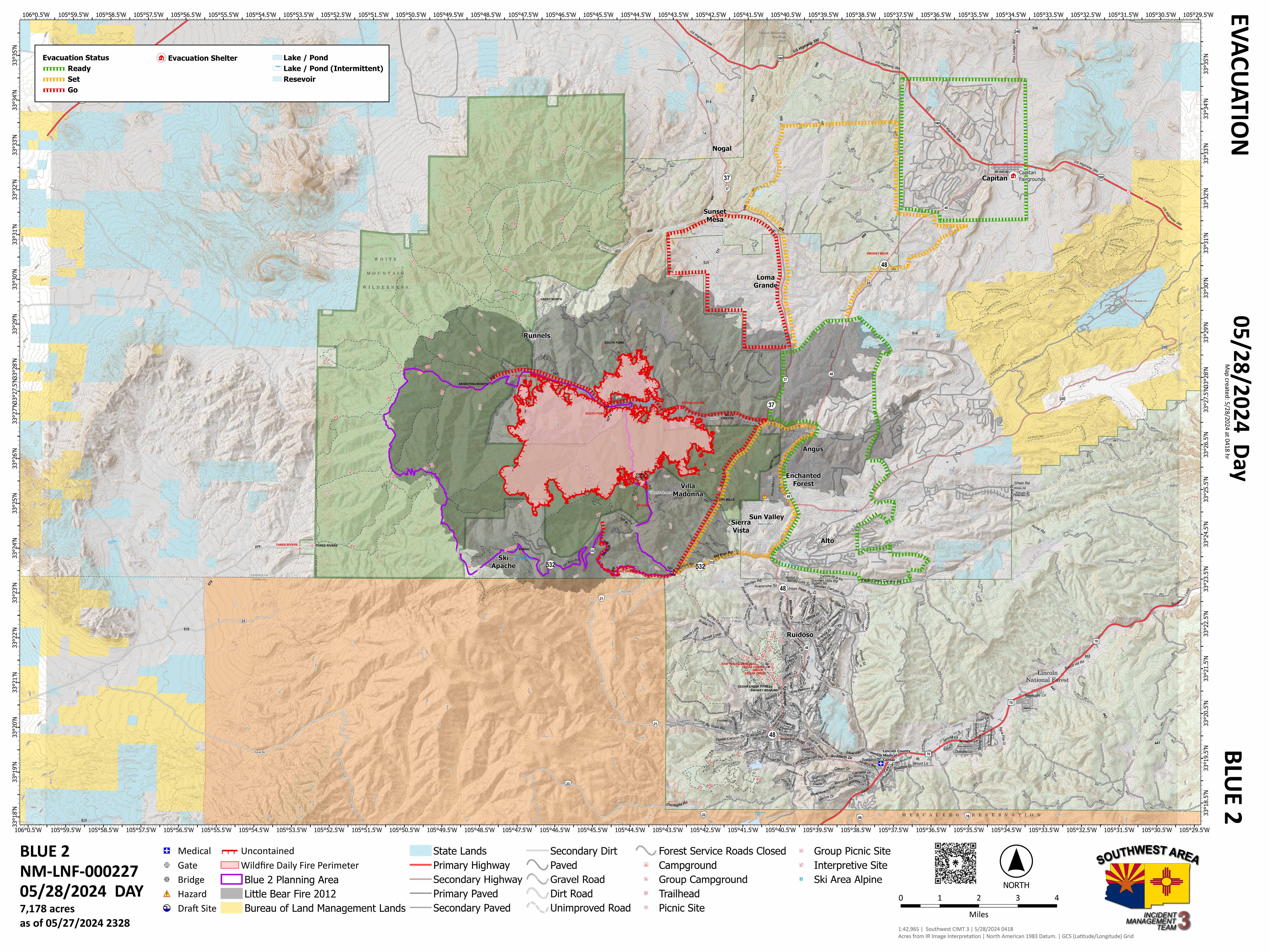
Daily Update : Air Resources are Using Water and Retardant to Suppress the Blue 2 Fire 05 28 2024
Related Incident: Blue 2 Fire
Publication Type: News
Air Resources are Using Water and Retardant to Suppress the Blue 2 Fire
Daily Update: May 28,2024
Fire Information Phone Number: (575) 386-5077; open from 7 a.m. to 7 p.m.
Media Phone Number: 575-386-5108; open from 7 a.m. to 7 p.m.
Email: 2024.blue2@firenet.gov
Acres: 7,178
Start Date: May 16, 2024
Location: White Mountain Wilderness approximately 8 miles North of Ruidoso
Personnel: 533
Cause: Lightning
Containment: 0%
Fuels: Timber (litter and understory)
Resources: 10 crews | 32 engines | 6 helicopters | 6 bulldozers | 5 Water Tenders
Highlights: Firefighters continue to use direct tactics to build fireline along the fire’s edge using hand tools and bulldozers while ensuring safety for all crews. Air resources are dropping water and retardant along the firelines for reinforcement purposes and to cool down the most active parts of the fire. A feller buncher is being used in the Ski Run Road area to remove debris and allow crews to gain access for suppression efforts. Firefighters continue to place sprinklers and hoses around houses for structure protection.
Fire Activity: The fire is producing more smoke and continues to be active, even during the nighttime, because of hot temperatures and dry conditions.
Weather: Although there are less winds, it is very dry with little chance of rain and hot temperatures.
Closures: Lincoln National Forest Alerts and Notices
Evacuations: For the latest information visit the Lincoln County Office of Emergency Services Blue Fire 2 Update page
For Ready, Set, Go Status definitions, please visit Ready, Set, Go! New Mexico


Indios Fire Operational Update Videos May 27, 2024 05 27 2024
Related Incident: Indios Wildfire
Publication Type: Announcement
Southwest Area Incident Management Team 4 has posted English and Spanish Operational Update Videos for the Indios Fire for Monday, May 27, 2024 on the Santa Fe National Forest's Facebook page