
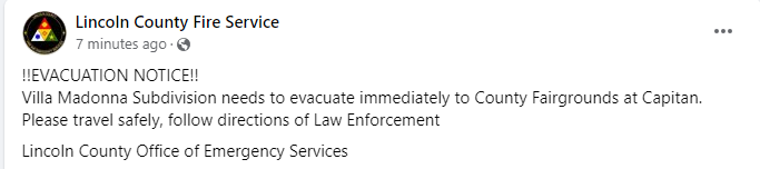
!!EVACUATION NOTICE!! Villa Madonna Subdivision needs to evacuate immediately to County Fairgrounds at Capitan. 05 25 2024
Related Incident: Blue 2 Fire
Publication Type: Announcement
From Lincoln County Office of Emergency Services: "Villa Madonna Subdivision needs to evacuate immediately to County Fairgrounds at Capitan. Please travel safely, follow directions of Law Enforcement:

Evacuation Information
Lincoln County Evacuation Information & Sign Up for CODERED
Lincoln County Fire Service Facebook
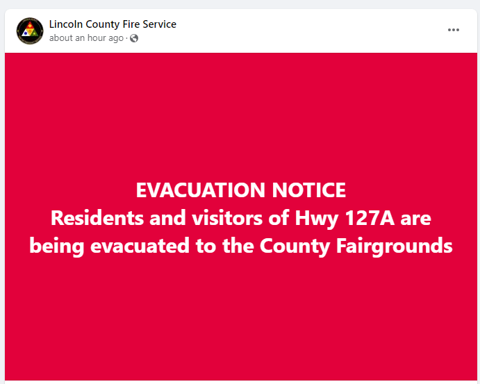
EVACUATION NOTICE Residents and visitors of Hwy 127A 05 25 2024
Related Incident: Blue 2 Fire
Publication Type: Announcement
Source: https://www.facebook.com/lincolncountyfireservice For current evacuation information follow: https://www.facebook.com/lincolncountyfireservice

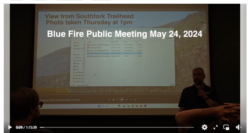
Recording of May 24, 2024 Town Hall Meet Available on Facebook 05 25 2024
Related Incident: Blue 2 Fire
Publication Type: Announcement
Blue 2 Fire Evening Update, May 24, 2024 05 25 2024
Related Incident: Blue 2 Fire
Publication Type: News
Update: Today's mission focused on air and ground operations. The Southwest Complex Incident Team is enroute and will transition Sunday.
There is a new closure order issued by the Lincoln National Forest, Smokey Bear District. The restricted area is National Forest System lands, roads, and trails within and around the Smokey Bear District on the Lincoln National Forest. The western boundary of the Restricted Area is located at the junction of National Forest Service Road (NFSR) 400 and NFSR 108 Tanbark, NFSR 108 Tanbark to NFSR 107, NFSR 107 to Big Bonito trail #36 to the junction of Aspen Trail # 35, Aspen Trial #35 to the junction of Crest Trail #25, Crest Trail #25 to the junction of Trail # 78, Trail #78 to the Forest Boundary. The Southern boundary is the Forest Boundary from trail# 78 going east for approximately 4.75 miles, then due north for approximately 1/10 of a mile to road 532, road 532 east to the Forest Service Boundary. The eastern boundary is the Forest Service Boundary due north approximately 9 miles north to NFSR 400. The northern boundary is NFSR 400 west to the junction of NFSR 108 Tanbark Canyon, the junction of Rodamaker Trail# 20 along NFSR 107 to the Big Bonito trail #36. The purpose of this Order is to protect the safety of firefighter personnel and the public as firefighters engage in suppression tactics on the Blue 2 wildfire.
This Order shall be in effect from May 23, 2024, at 12:01 a.m. through 23 August 2024, at 12:01 p.m., unless rescinded. 2. A map identifying the Described Area is linked below.
Lincoln County has declared a state of disaster to ensure resource availability and has activated an Emergency Contact Center: (575) 336-8600. Emergency shelter is located at the Capitan Fairground and also has capability to house animals. Lincoln County Fire Service advises citizens to sign up for CodeRed (see link below) even if you are not impacted by this fire, it is an important resource for local residents.
Current Evacuations issued by the Lincoln County Sheriffs Office are under effect for Bonito Lake Rd, Forest Service Road 108, and Forest Service Road 107. At this time, the Angus Area, Villa Madonna, Sierra Vista & Sun Valley subdivisions on the west side of Hwy48 should also be ready for evacuations. Operations Emergency Services has established an evacuation reception center at the Capitan Fairgrounds.
Please keep 911 open and available for emergencies.
The public townhall meeting will be added to our incident Facebook page.
Start Date I Time: May 17, 2024, approximately 3:45 p.m.
Cause: Lightning
Size: Blue 2 Fire: Estimated 3,300
Location: White Mountain Wilderness
Resources: 88 Personnel, more EnRoute
Vegetation/Fuels: Dead and dead/down trees
Containment: 0%
Tactic: Full Suppression
Smoke: Moderate / Wind Influenced Smoke
Evacuation: Go Now: Bonito Lake Road, Forest Service Road 108, Forest Service Road 107
Be Set: Villa Madonna Subdivision, Sierra Vista Subdivision, Sun Valley Subdivision
Be Ready: Angus Area
Shelters: Lincoln County Fairgrounds/ 101 5th St. Capitan NM 88316
Animal Shelters: Humane Society of Lincoln County/ 25962 US Hwy 70 Ruidoso NM 88345
Area Closures: Part of White Mountain Wilderness Area, See attached map for more details.
More Information:
Facebook: www.facebook.com/LincolnNationalForest NM Fire Info: www.NMFirelnfo.com
lnciWeb: https://inciweb.wildfire.gov/incident-information/nmlnf-blue-2-fire Lincoln County CodeRed: bit.ly/4bwMk8n
New Closure Order Map: https://www.fs.usda.gov/alerts/lincoln/alerts-notices.
Blue 2 Emergency Closure Order 03080124002 05 28 2024
Related Incident: Blue 2 Fire
Publication Type: Closures
There is a new closure order issued by the Lincoln National Forest, Smokey Bear District. The restricted area is National Forest System lands, roads, and trails within and around the Smokey Bear District on the Lincoln National Forest. The western boundary of the Restricted Area is located at the junction of National Forest Service Road (NFSR) 400 and NFSR 108 Tanbark, NFSR 108 Tanbark to NFSR 107, NFSR 107 to Big Bonito trail #36 to the junction of Aspen Trail # 35, Aspen Trial #35 to the junction of Crest Trail #25, Crest Trail #25 to the junction of Trail # 78, Trail #78 to the Forest Boundary. The Southern boundary is the Forest Boundary from trail# 78 going east for approximately 4.75 miles, then due north for approximately 1/10 of a mile to road 532, road 532 east to the Forest Service Boundary. The eastern boundary is the Forest Service Boundary due north approximately 9 miles north to NFSR 400. The northern boundary is NFSR 400 west to the junction of NFSR 108 Tanbark Canyon, the junction of Rodamaker Trail# 20 along NFSR 107 to the Big Bonito trail #36. The purpose of this Order is to protect the safety of firefighter personnel and the public as firefighters engage in suppression tactics on the Blue 2 wildfire.
This Order shall be in effect from May 23, 2024, at 12:01 a.m. through 23 August 2024, at 12:01 p.m., unless rescinded. 2. A map identifying the Described Area is linked below.
Esquibel Prescribed Fire Could Begin Next Week 05 25 2024
Related Incident:
Publication Type: News
For the Record: An earlier version of this news release stated ignitions could begin as early as May 26. The correct date is May 27. We regret the error.
Working with a meteorologist, Carson National Forest fire managers are looking for opportunities to begin the Esquibel Prescribed Fire to the north of Tres Piedras, N.M. As of this morning’s forecast, a timeframe for fire crews to begin ignitions could arrive as early as Monday, May 27, after a red flag warning on Saturday.
“As we do for each prescribed fire, we are watching the weather and conditions very closely,” said District Ranger Angie Krall, who will be the approving official on the project. “If the forecast changes for the worse, so will our plans, and the work will be postponed.”
To obtain on-site weather data more accurately, fire crew members set up a mobile remote automatic weather station near the prescribed fire unit.
The Esquibel Unit is 2,962 acres. It is located northwest of Tres Piedras and south of Forest Road 83 (map).
Crews will apply fire to the understory of forested areas, targeting fuels on the forest floor, such as leaf litter, downed branches, brush. The fire may fully burn occasional single trees or stands, which will help create an open canopy. Crews will use recently greened-up grassland areas within the unit as holding features, along with the Forest Road 83 and two prescribed fires from 2015 and 2021.
Ignitions are expected to last up to two days. Once complete, crews will regularly patrol and monitor the fire until it’s called out.
The public can get updates for the prescribed fire on InciWeb, Carson National Forest social media (Facebook, X) and New Mexico Fire Information. Air quality data can be found at the Fire and Smoke Map.
Blue 2 Fire Morning Update, May 24, 2024 05 24 2024
Related Incident: Blue 2 Fire
Publication Type: News
Update: Yesterday's Red Flag conditions created increased smoke and fire activity from the Blue 2 Fire that is currently burning in the White Mountain Wilderness area. The fire size is currently estimated at 1,478 acres, but a heavy smoke layer makes an accurate estimate difficult. Crews remained on the fire throughout the night last night. The fire continues to burn dead and down trees and standing dead trees (snags) that were left after the Little Bear fire in 2012.
Today's operations will consist of air and ground operations. Expect to see aircraft as weather permits. Ground Operations are shifting to operating day & night. A Complex Incident Management Team was ordered last night at midnight and is currently enroute.
As was dictated last night by fire behavior, Lincoln County activated an Emergency Contact Center: (575) 336-8600 and there is currently an emergency shelter, and animal emergency shelter in ace.
Lincoln County Fire Service advises citizens to sign up for CodeRed (see link below) even if you are not impacted by this fire, it is an important resource for local residents.
Current Evacuations issued by the Lincoln County Sheriff's Office are under effect for Bonito Lake
Rd, Forest Service Road 108, and Forest Service Road 107. At this time, the Angus Area, Villa Madonna, Sierra Vista & Sun Valley subdivisions on the west side of Hwy48 should also be ready for evacuations. Operations Emergency Services has established an evacuation reception center at the Capitan Fairgrounds.
Please keep 911 open and available for emergencies.
There will be a public meeting Friday (May 24, 2024) evening at 7:00 pm. The meeting will be held at the Eastern New Mexico University-Ruidoso Branch Community College 709 Mechem Drive, Ruidoso NM.
Start Date I Time: May 17, 2024, approximately 3:45 p.m.
Cause: Lightning
Size: Blue 2 Fire: Estimated 1,478 acres
Location: White Mountain Wilderness
Resources: 88 Personnel, more EnRoute Vegetation/Fuels: Dead and dead/down trees Containment: 0%
Tactic: Full Suppression
Smoke: Moderate / Wind Influenced Smoke
Evacuation: Go Now: Bonito Lake Road, Forest Service Road 108, Forest Service Road 107
Be Set: Villa Madonna Subdivision, Sierra Vista Subdivision, Sun Valley Subdivision
Be Ready: Angus Area
Shelters: Lincoln County Fairgrounds / 101 5th St. Capitan NM 88316
Animal Shelters: Humane Society of Lincoln County I 25962 US Hwy 70 Ruidoso NM 88345
Area Closures: Part of White Mountain Wilderness Area, See link for more information: https://inciweb.wildfire.gov/incident-publication/nmlnf-blue-2-fire/-closure-update-for-trails-on white-mountain-wilderness-area-05-22-2024
More Information:
Facebook: www.facebook.com/LincolnNationalForest NM Fire Info: www.NMFirelnfo.com
lnciWeb: https://inciweb.wildfire.gov/incident-information/nmlnf-blue-2-fire
Lincoln County CodeRed: bit.ly/4bwMk8n
Wildcat Fire Update 05 24 2024
Related Incident: Wildcat Fire
Publication Type: News
Highlights: The Wildcat Fire footprint remains the same size as Thursday. Fire crews are still conducting fire suppression. Their efforts resulted in zero fire growth on Thursday.
Operations: Fire crews are continuing to scout, patrol, and monitor the Wildcat Fire to prevent any further spreading. The public is cautioned to be aware of their surroundings in order to drive safely through the areas active with firefighters and emergency vehicles.
Weather: Low relative humidity and warmer conditions will continue for the next few days. A dry weather system entering the area today will produce erratic and gusty southwesterly winds gusting from 25 to 30 miles per hour in the afternoon.
Closures and Restrictions: The previous closure order that was in effect for the Cave Creek Ranger District due to the Wildcat Fire has been superseded by a new modified Closure Order which began Thursday, May 23. The order allows public access to Rio Verde Drive, Bartlett Dam Road, Needle Rock Road, North Lake Road, Horseshoe Dam Road, and Cave Creek Road/Seven Springs Road. Fire crews will still be working to contain the Wildcat Fire, and the public is cautioned to drive safely through the area and be aware of their surroundings. The Cave Creek Ranger Station will now be open to the public. Office hours are 8 a.m. to 4:30 p.m. Monday through Friday. The Tonto National Forest began Emergency Stage 1 Fire Restrictions yesterday. The restrictions and closure orders are available on the Tonto National Forest website at https://www.fs.usda.gov/alerts/tonto/alerts-notices/?aid=87558
Safety: The health and safety of firefighters and the public are always the highest priority. The public is urged to sign up for the Maricopa County Emergency Notification System. The system allows you to be quickly notified of possible emergency evacuations. To learn more about the Arizona Emergency Information Network visit: https://ein.az.gov/ready-set-go.
Smoke: Smoke from the Wildcat Fire may be visible in the surrounding areas. Smoke will drift to the north and east due to prevailing winds. Individuals who are sensitive to smoke, and people with heart disease are encouraged to take precautionary measures. An interactive smoke map at https://fire.airnow.gov/ allows you to zoom into your area to see the latest smoke conditions.
Location: East of the Desert Mountain Community and Tonto Hills Development; West of Bartlett Lake Reservoir in the Cave Creek Ranger District.
Start Date: May 18, 2024
Size: Approximately 14,402 acres
Percent Contained: 64%
Cause: Human-caused.
Vegetation: The fire continues to burn grass and brush.
Resources: 2 crews, 7 fire engines, and 2 water tenders.
Number of Personnel Assigned: 110
Information Links and Contacts:
Tonto National Forest https://www.fs.usda.gov/main/tonto/fire
InciWeb Aztnf Wildcat Fire Information | InciWeb (wildfire.gov)
Fire email 2024.wildcat@firenet.gov
Information Phone: (480) 608-2181
Daily Update: 05 24 2024
Related Incident: Indios Wildfire
Publication Type: News
Daily Update
Friday, May 24, 2024
Acres: 1809
Start Date: 5/19/2024
Location: 7 miles north of the village of Coyote, N.M.
Personnel: 133
Containment: 0%
Fuels: Timber, litter, understory
Resources: 5 crews | 1 helicopter | 5 engines| 1 road grader | 2 masticators | 1 water tender
Highlights: Closure Order 03-10-01-24-02 is in place and includes all National Forest System lands within the boundary of the Coyote Ranger District starting from the Continental Divide trail #298 at Highway 96 going north across Forest Road (FR) 77, through the Chama River Canyon Wilderness to Skull Bridge (Ojitos Trail head) on FR 151. FR 11 northwest to the Chama River Canyon Wilderness boundary and Junction with FR 8; FR 169 (from junction with FR 11) south to FR 473; FR 473 south to FR 64; FR 64 South to the junction of FR 77; and FR 77 east to the Chama River Canyon Wilderness boundary. FR 77 from the Forest boundary and County Road 418 to the junction of FR 64 and FR 77. The Chama River Canyon Wilderness south of Rio Gallina and south of Rio Chama.
For CDT hikers impacted by this closure, camping will be available at the Coyote Ranger Station and water will be available.
Fire Activity: The fire continues to burn within the Chama River Canyon Wilderness in steep, inaccessible terrain. On Thursday, with near critical fire weather conditions, the fire grew as expected but is still within the larger potential perimeter. The fire spotted into the 2017 Ojitos Fire area yesterday. Today, two Interagency Hotshot crews and three engines will begin to work around this spot, anchoring into natural barriers and tying the line into the existing road systems. Fire managers continue to be strategic in their approach. While the helicopter was not used on the southern edge as initially planned, crews conducted some small but crucial strategic firing operations. These operations aimed to reduce fuels between FR 473 and the fire's edge on the southwest perimeter. More firing operations are likely to be used. This will help minimize fire effects by using low to moderate intensity firing and reducing vegetation between lines and the main fire.
Local engines continued to hold, secure, and patrol along FR 473 further north. Two masticators progressed in Gamble Oak on the fire's west side and got good depth on the lines in that area. The Mount Taylor and Black Mesa Interagency Hotshot Crews will begin work today, bringing the total number of IHCs to five.
Weather: Today, the high temperature will be around 72 degrees, and the minimum humidity will be 11-15 percent. Winds will be west 5-7 mph in the morning, increasing to 8-13 mph in the afternoon, with gusts to 25 mph. Wind trends will be stronger on Saturday, creating critical fire weather conditions despite the slight increase in humidity.
Smoke: Smoke is visible and local communities may experience smoke impacts along Highways 96, 112, and 84.
Closures: See today’s Highlights for current closure order information. Visit Inciweb for the full order and map.
Temporary Flight Restrictions: There is a TFR in place around the fire area.
More Information: 575-323-2290 | 2024.indios@firenet.gov | x.com/SantafeNF | facebook.com/santafeNF
inciweb.wildfire.gov/incident-information/nmsnf-indios-wildfire
Spruce Creek Fire Update 05 24 2024
Related Incident:
Publication Type: News
Fire start date: May 14, 2024
Fire size today: 5,699 acres
Location: 11 miles Northeast of Dolores, CO on Haycamp Mesa
Personnel: 179
Cause: Lightning
Containment: 38%
Evacuation Information:
There are no current evacuations.
Fire Area and Roads Closure:
https://inciweb.wildfire.gov/incident-information/cosjf-2024-spruce-creek-co
Latest Smoke Outlook:
https://fire.airnow.gov/?aqi_v=2&m_ids=&pa_ids=%23
INCIDENT OBJECTIVES:
- Provide for firefighter and public safety throughout all phases of the incident
- Manage hazards to responders and the public using a risk-based approach to decision-making on a continual basis
- Protect critical values at risk
- Reduce the long-term risk to communities from future wildfire events
YESTERDAY’S OPERATIONS:
- Firefighters completed a multi-day firing operation yesterday afternoon, locking the fire within previously defined indirect boundaries along natural features and existing roads.
TODAY’S PLAN:
- Following completion of firing operations, fire crews will patrol and secure fireline. Unmanned Aerial Systems (drones) will provide aerial monitoring.
- Interior pockets of unburned fuel, such as pine needles, Gambel oak and dead and downed trees, are expected to continue to smolder and burn.
- Smoke will be visible throughout the area and may settle into valleys and other low-lying areas, especially at night and in the early morning hours. Wildfire smoke may affect your health. For more information, please go to: https://www.colorado.gov/pacific/cdphe/wood-smoke-and-health
WEATHER:
- Friday will begin with areas of smoke and mostly clear skies. Winds will be light and out of the southwest, with the high temperature in the low-60’s. Cloud cover will increase in the afternoon with an approaching disturbance that will move through the region on Saturday.