
Daily Update: 05 23 2024
Related Incident: Indios Wildfire
Publication Type: News
Daily Update
Thursday, May 23, 2024
Acres: 851
Start Date: 5/19/2024
Location: 7 miles north of the village of Coyote, N.M.
Personnel: 127
Containment: 0%
Fuels: Timber, litter, understory
Resources: 3 crews | 1 helicopter | 5 engines| 1 road grader | 2 masticators
Highlights: The Northern New Mexico Type 3 team, Incident Commander Luke McLarty, assumed command of the fire on Wednesday, May 22. The fire is currently burning within the Chama River Canyon Wilderness along the southwestern boundary, northwest of the 2017 Ojitos Fire burn area. Fire managers intend to use a containment strategy within a predetermined area to allow fire to play its natural role in this fire-dependent ecosystem.
Several factors, including firefighter safety, terrain, resource availability, fire behavior, past prescribed fire units and vegetation management projects in the area, threats to public safety and property, and fire season outlook and modeling, inform wildfire management decisions. The Type 3 IMT, working with the Santa Fe National Forest, will discuss altering management strategies if conditions change.
Fire Activity: On Wednesday, the fire was most active along the south and southeast perimeter. Today, fire managers may utilize a helicopter to drop water and cool this edge of the fire, giving crews time to continue prepping the line along Forest Roads 11 and 169E. The Carson and Sacramento Interagency Hotshot Crews and two masticators are prepping the line along FR 169E, and the Santa Fe IHC will begin work today.
Several local engines patrolled and secured a constructed handline on the northwest perimeter that runs west to FR 169E. Crews were also clearing along Forest Roads 8 and 11. Working with Resource Advisors, a grader operator began road improvement on FR 8 to allow safer access to the area. Fire managers continue to scout further out from the fire on the south and east sides to look for options should the fire move further in those directions.
Weather: Critical fire weather conditions are expected today and tomorrow. Light winds will gradually increase each morning, peaking in late afternoon or early evening. Today’s high temperature will be around 73 degrees, with a minimum humidity of 8-12 percent. Winds will be west at 5-7 mph in the morning and 13-18 mph in the afternoon, with gusts to 30 mph possible.
Smoke: Smoke is visible and local communities may experience smoke impacts along Highways 96, 112, and 84.
Closures: The Continental Divide Trail (CDT) is closed from Skull Bridge to the Highway 96 crossing. Please use alternate routes. Please drive slowly and watch for fire personnel on FRs 8, 11, and 169E and avoid them if possible.
Evacuations: There are currently no evacuations.
More Information: 575-323-2290 | 2024.indios@firenet.gov | x.com/SantafeNF | facebook.com/santafeNF
inciweb.wildfire.gov/incident-information/nmsnf-indios-wildfirev
Blue Fire Evening Update, May 22, 2024 05 22 2024
Related Incident: Blue 2 Fire
Publication Type: News
Update: The Blue 2 Fire remains at approximately 48 acres and is burning within the White Mountain Wilderness in an area previously burned by the Little Bear fire in 2012. This area has mostly dead and down fuels in steep and rugged terrain with numerous snags in the area. A transfer of command from the local unit to the Albuquerque Zone Type 3 Incident Management Team is set to take place Thursday, May 23, 2024 at 7:00am.
“We want to be strategic about where we engage this fire,” said Jennifer Thomas, District Ranger for Smokey Bear Ranger District. “Crews will be assessing existing trail systems and roadways as possible containment lines”
Part of the suppression efforts include restricting access to part of the National Forest wilderness within and around the White Mountain Area. CLICK FOR MORE
The western boundary of the restricted area is located at the junction of National Forest Service Road (NFSR) 107 and Big Bonito trail #36, to the junction of Aspen Trail # 35 35 to the junction of Crest Trail #25.
The Southern boundary is at the junction of Aspen Trail # 35 and the Crest Trail #25 along the crest trail to the junction of Rodamaker Trail # 20.
The eastern boundary is the junction of the crest trail and Rodamaker Trail # 20 along the Rodamaker Trail # 20 to the junction of NFSR 107.
The northern boundary is the junction of Rodamaker Trail # 20 along NFSR 107 to the Big Bonito trail #36.
Light smoke may be visible, but significant impacts to the community are not currently expected.
More Information:
Facebook: www.facebook.com/LincolnNationalForest
NM Fire Info: www.NMFireInfo.com
InciWeb: https://inciweb.wildfire.gov/incident-information/nmlnf-blue-2-fire
Closure information: https://inciweb.wildfire.gov/incident-publication/nmlnf-blue-2-fire/-closure-update-for-trails-on-white-mountain-wilderness-area-05-22-2024
You can expect another update tomorrow, May 23, 2024.
Start Date / Time: May 17, 2024, approximately 3:45 p.m.
Cause: Lightning
Size: Blue Fire:.5 acres Blue 2 Fire: 48 acres
Location: White Mountain Wilderness
Resources: Aerial and ground surveillance
Types of vegetation in the area (aka fuels): Dead and dead/down trees
Containment: 0%
Tactic: Full Suppression
Road Closures: None
Smoke: Light
Evacuations: None
Area Closures: Part of White Mountain Wilderness Area
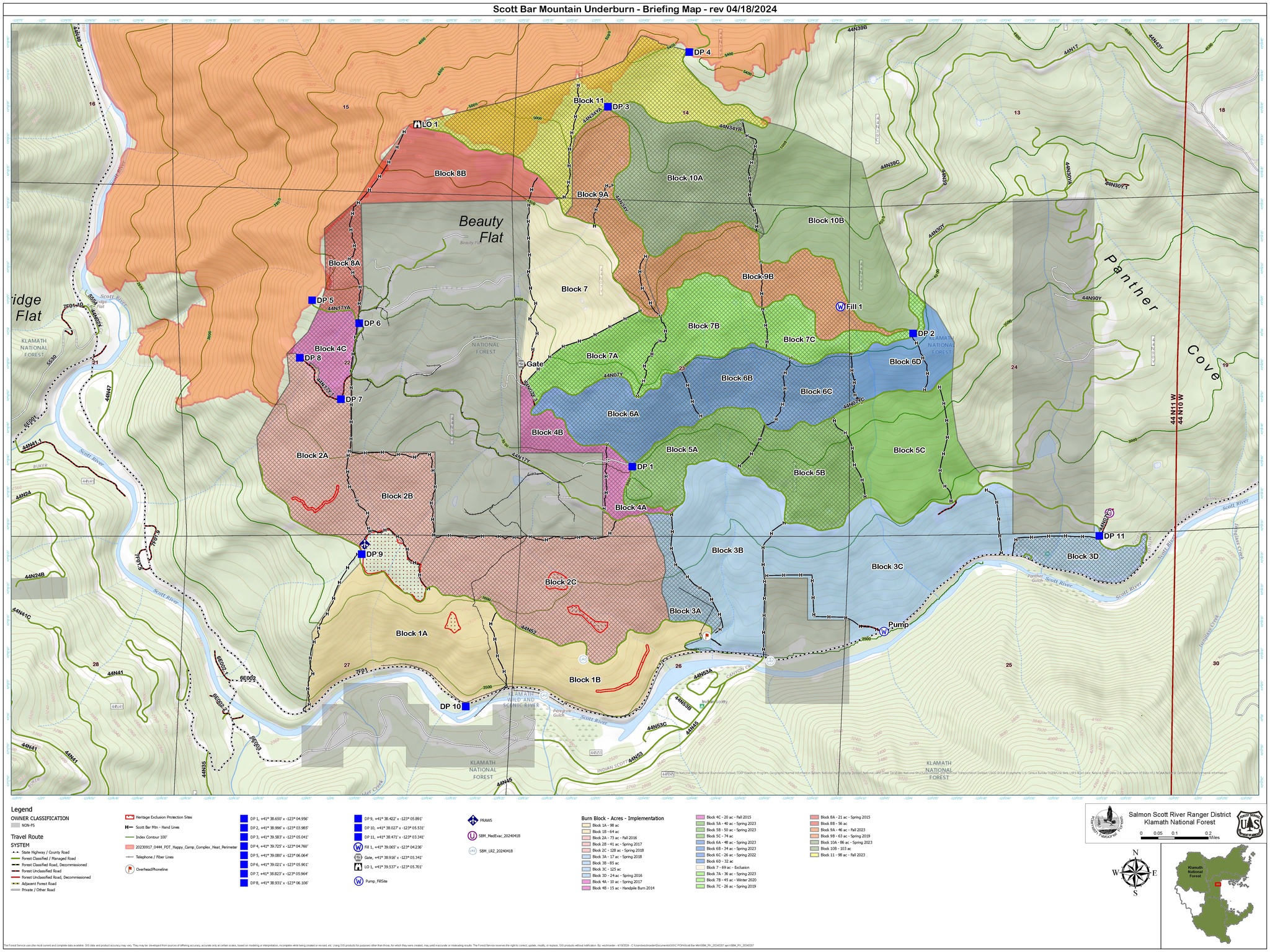
Prescribed Burning at Scott Bar Mountain Begins 05 22 2024
Related Incident:
Publication Type: Announcement
The Salmon-Scott Ranger District will conduct prescribed burning on the Scott Bar Mountain RX along the Scott River Road from 05/21/24 to 05/24/24. This project aims to burn 125 acres in unit 3C (see attached map) in order to minimize negative fire effects to Oak woodland by reducing surface and ladder fuels. There will be no direct ignition in riparian reserves, or salamander (talus) habitat, or in archeological sites.
Prescribed fire is an important and cost-effective way for fire managers to decrease fuel loadings, improve forest health, and enhance wildlife habitat in the ecosystems of the Klamath National Forest, which evolved with fire. Prescribed fire mimics the effects that naturally occurring fire used to provide to the landscape. These effects include the reduction of fuels, such as sticks and logs, and ladder fuels like smaller trees and brush. This reduction of fuels from prescribed burns promotes a forest that is more resilient to the effects of wildfire, insects, and disease. Decreased fuel loads also help to improve firefighter safety and defensibility of communities during wildfires.
All prescribed fire projects are conducted in accordance with an approved burn plan developed by specialists to ensure the objectives of the burn are met while ensuring the safety of people and property in the area. Burn plans describe the specific conditions under which burns will be conducted including the weather, number of personnel, and opportunities to minimize smoke impacts.
Visitors are asked to avoid areas where prescribed burns are being conducted. Some spur roads near the burn areas may be inaccessible during operations.
As a result of the burn, some residents and visitors may see or smell smoke. They may also witness glowing from the fires at night. People should not be alarmed; the fires will be carefully monitored. Local authorities will be notified prior to burn days and kept informed throughout burning operations.
Closure update for trails on White Mountain Wilderness Area 05 22 2024
Related Incident: Blue 2 Fire
Publication Type: Closures
ALAMOGORDO, N.M, May 22, 2023 – Effective Wednesday, May 22, 2024, the Lincoln National Forest has issued a closure order for several trails within the White Mountain Wilderness Area on the Smokey Bear Ranger District.
The restricted areas are National Forest System lands, roads, and trails within and around the White Mountain Wilderness.
The western boundary of the restricted area is located at the junction of National Forest Service Road (NFSR) 107 and Big Bonito trail #36, to the junction of Aspen Trail # 35 35 to the junction of Crest Trail #25.
The Southern boundary is at the junction of Aspen Trail # 35 and the Crest Trail #25 along the crest trail to the junction the junction of Rodamaker Trail # 20.
The eastern boundary is the junction of the crest trail and Rodamaker Trail # 20 along the Rodamaker Trail # 20 to the junction of NFSR 107.
The northern boundary is the junction of Rodamaker Trail # 20 along NFSR 107 to the Big Bonito trail #36.
The purpose of this order is to protect the safety of firefighter personnel and the public as firefighters engage in suppression tactics on the Blue 2 wildfire.
Announcements will be made when the trails reopen. For updates on the Blue 2 wildfire, please follow the incident on social media or on Inciweb:
Facebook Page: www.facebook.com/Blue2Fire
Inciweb Link: www.inciweb.wildfire.gov/incident-information/nmlnf-blue-2-fire
Wildcat Fire Update05 22 2024
Related Incident: Wildcat Fire
Publication Type: News
Highlights: Wildcat Fire increased slightly from 14,072 to 14,402 acres. Fire crews continue fire suppression operations which has resulted in limited fire growth.
Operations: The fire continues to be active on the southeast side of the fire perimeter due to weather conditions. Fire crews are continuing to scout and construct fire lines to prevent fire spread.
Weather: Low relative humidity and warmer conditions will persist for the next several days. South winds are
expected to gust between 15 and 20 miles per hour. The winds are expected to decrease in the evening.
Closures: The Tonto National Forest is scheduled to begin Emergency Stage 1 Fire Restrictions on Thursday morning at 8 a.m. A closure order is in effect for the protection of public health and safety due to firefighting operations. Bartlett Lake Road remains closed. The public is urged to stay away from the area. This is for the safety of the public and firefighters. The closure order is available on the Tonto National Forest website at https://www.fs.usda.gov/alerts/tonto/alerts-notices/?aid=87558
Safety: The health and safety of firefighters and the public are always the highest priority. Please avoid the area while crews conduct fire suppression operations. The public is urged to sign up for the Maricopa County Emergency Notification System. The system allows you to be quickly notified of possible emergency evacuations. To learn more about the Arizona Emergency Information Network visit: https://ein.az.gov/ready-set-go. Firefighting aircraft and drones are a dangerous combination. Drones in the area could lead to accidents or slow down wildfire suppression operations. If you fly…we can’t.
Smoke: Smoke from the Wildcat Fire may be visible in the surrounding areas for many days and will drift to the north and east due to prevailing winds. Individuals who are sensitive to smoke and people with heart disease are encouraged to take precautionary measures. An interactive smoke map at https://fire.airnow.gov/ allows you to zoom into your area to see the latest smoke conditions.
Location: East of the Desert Mountain Community and Tonto Hills Development; West of Bartlett Lake Reservoir in the Cave Creek Ranger District.
Start Date: May 18, 2024
Size: Approximately 14,402 acres
Percent Contained: 36%
Cause: Under investigation.
Vegetation: The fire is burning grass and brush.
Resources: 3 crews, 8 fire engines, and 2 water tenders.
Number of Personnel Assigned: 197
Information Links and Contacts:
Tonto National Forest https://www.fs.usda.gov/main/tonto/fire
InciWeb https://inciweb.wildfire.gov/incident-information/aztnf-wildcat-fire
Fire email 2024.wildcat@firenet.gov
Information Phone: (480) 608-2181
Evacuations and Road Closures Lifted 05 22 2024
Related Incident:
Publication Type: Announcement
All evacuations and road closures have been lifted for the area.
Spruce Creek Fire Update 05 22 2024
Related Incident:
Publication Type: News
Fire start date: May 14, 2024
Fire size today: 1,867 acres
Location: 11 miles Northeast of Dolores, CO on Haycamp Mesa
Personnel: 172
Cause: Lightning
Evacuation Information:
There are no current evacuations.
Fire Area and Roads Closure:
https://inciweb.wildfire.gov/incident-information/cosjf-2024-spruce-creek-co
Latest Smoke Outlook:
https://fire.airnow.gov/?aqi_v=2&m_ids=&pa_ids=%23
INCIDENT OBJECTIVES:
- Provide for firefighter and public safety throughout all phases of the incident
- Manage hazards to responders and the public using a risk-based approach to decision-making on a continual basis
- Protect critical values at risk
- Reduce the long-term risk to communities from future wildfire events
YESTERDAY’S OPERATIONS:
- Firefighters made significant progress securing the edges of the northern and western indirect fire boundaries, using patrols and crews with hand tools and water.
- Crews also worked to further protect cultural heritage sites from fire impact.
TODAY’S PLAN:
- The incident management team plans to use two aerial ignitions teams and hand crews to secure the previously defined indirect boundaries along natural features and existing roads. These indirect tactics have been determined to be the best approach to both containing the fire and reducing long-term fire risk to area communities.
- Smoke will likely be very visible throughout the area, and may settle into valleys and other low-lying areas, especially at night and in the early morning hours. Wildfire smoke may affect your health. For more information, please go to: https://www.colorado.gov/pacific/cdphe/wood-smoke-and-health
WEATHER:
- Lower humidity and warmer temperatures are forecast for Wednesday. High temperatures in the fire area will be in the upper 50s to low 60s with light southwesterly winds.
Blue Fire Evening Update, May 21, 2024 05 21 2024
Related Incident: Blue 2 Fire
Publication Type: News
Update: Based on aerial observations, the Blue Fire has not shown any growth, and is remaining at .5 acres. Blue 2 Fire is also holding at 45 acres. The overall strategy for the Blue 2 Fire is to continue monitor while allowing it to take its course as much as possible. The remote location and severe terrain that the wildfires make the wildfire unsafe to engage directly at this time, and a safe perimeter is being determined for crews to contain the wildfire. The objective in fire management on a Designated Wilderness Area is to permit the wildfire to play its natural role as much as possible within the wilderness. If it is determined that the wildfire poses a threat to values adjacent to the Wilderness Areas, action will be taken to protect those assets. The Lincoln National Forest is a fire-adapted ecosystem. It depends on fire to play a natural role in restoring the landscape and wildlife to more natural conditions while preventing the occurrence of more extreme fires in the future.
More Information: Facebook: www.facebook.com/LincolnNationalForest
NM Fire Info: www.NMFireInfo.com
You can expect another update tomorrow, May 22, 2024.
Update on mandatory evacuations and roadblocks for HWY 82 05 21 2024
Related Incident:
Publication Type: Announcement
May 21, 2024: Roadblocks on HWY 82 are advised to be removed at 2000 this evening. Mandatory evacuations to be reduced to "ready" at the same time.
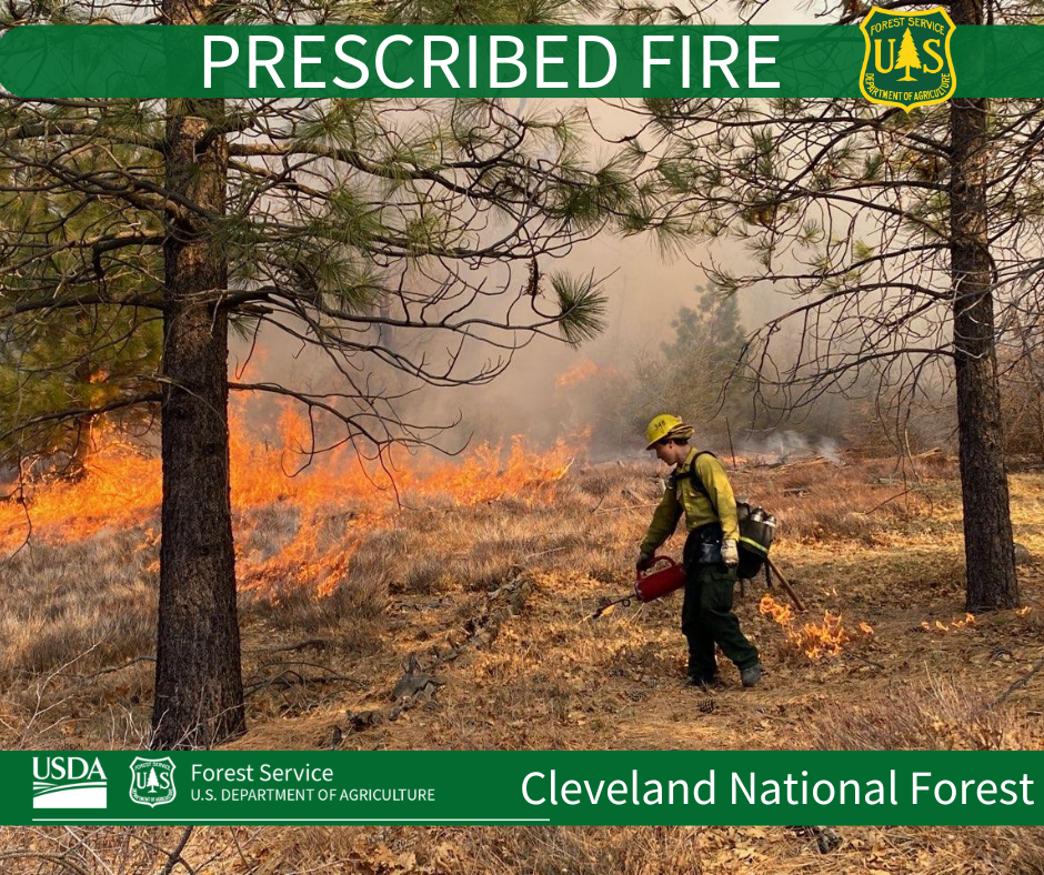
Descanso Ranger District Fuel Treatment 05 21 2024
Related Incident: 2025 - Cleveland National Forest, Forest Health Treatments
Publication Type: News
5/21/24 Fuel crews on the DRD are conducting a 115-acre broadcast burn at Cameron Fire Station today. Smoke will be seen from the I-8, and surrounding communities. Please DO NOT REPORT.
This project is funded in part by the President's Inflation Reduction Act, which is part of confronting the wildfire crisis.
Prescribed Fire is part of Confronting the Wildfire Crisis: https://fs.usda.gov/managing-land/wildfire-crisis. Prescribed fire plays an important role in forest health and in reducing extreme wildfires and their negative impact. These fires also help reduce heavy fuel loads while simultaneously opening the conifer forest structure and maintaining the health of meadow habitats. Fire is also used to enhance native plant communities and cultural landscapes and improve wildlife habitats. Another goal is to provide defensible space for communities and developed areas within and surrounding the CNF. With all fire comes smoke, and the U.S. Forest Service works to mitigate smoke impacts from prescribed fires on the communities in the area.