
Evacuations Are Underway 05 23 2024
Related Incident: Blue 2 Fire
Publication Type: Announcement

From Lincoln County OES: (Source: https://www.facebook.com/lincolncountyfireservice)
"Current evacuations are underway. Please keep 911 open and available for emergencies only. OES has established an evacuation reception center at the Capitan Fairgrounds.
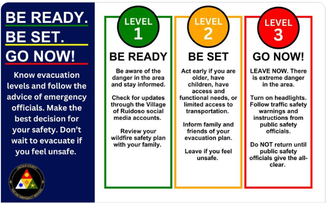
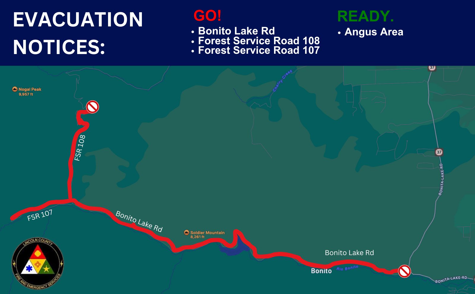
Go!
Bonito Lake Road
Forest Service Road 108
Forest Service Road 107
Set.
Currently we are placing the Villa Madonna Subdivision, Sierra Vista Subdivision and Sun Valley Subdivision on the West side of NM HWY 48 on the "Standby to evacuate" mode also known as "SET" THIS IS NOT AN EVACUATION NOTICE, just be prepared. We will issue a codeRED alert if we are evacuating.
Please continue to monitor this page and CodeRED for announcements. Go to the Forest Service Blue Fire page for Fire information
Ready.
Angus Area
#Blue2Fire #ReadySetGo #Wildfire #BonitoLake"
For current evacuation information follow: https://www.facebook.com/lincolncountyfireservice
From Lincoln County OES:
Current evacuations are underway. Please keep 911 open and available for emergencies only. OES has established an evacuation reception center at the Capitan Fairgrounds.
Go!
Bonito Lake Road
Forest Service Road 108
Forest Service Road 107
Set.
No Set Notices are in effect.
Ready.
Angus Area
Please stay out of the area and watch for emergency personnel. OES is monitoring the situation and taking appropriate action.
#Blue2Fire #ReadySetGo #Wildfire #BonitoLake
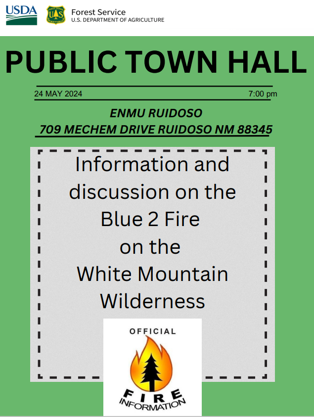
You Are Invited to a Public Town Hall 05 24 2024
Related Incident: Blue 2 Fire
Publication Type: Announcement
There will be a public meeting Friday (May 24, 2024) evening at 7:00 pm. The meeting will be held at the Eastern New Mexico University-Ruidoso Branch Community College 709 Mechem Drive, Ruidoso NM.

Blue Fire Evening Update, May 23, 2024 05 24 2024
Related Incident: Blue 2 Fire
Publication Type: News
Update: Today's Red Flag conditions created increased smoke and fire activity from the Blue 2 Fire that is currently burning in the White Mountain Wilderness area. The fire size is currently estimated at 700 acres, but a heavy smoke layer makes an accurate estimate difficult. The fire continues to burn dead and down trees and standing dead trees (snags) that were left after the Little Bear fire in 2012.
"Many of the firefighters that are currently working on the Blue fire worked on the Little Bear Fire," says Rich Dolphin, former Superintendent for the Smokey Bear Hotshots. "This fire is currently burning in dead and down fuels, not mature trees with crown fire activity like Little Bear."
Crews continue to prepare containment lines by cutting and removing dead trees. There is a significant amount of work to be done and more crews are arriving tomorrow. When appropriate, water bucket drops will be utilized to check the fire's spread.
"This continues to be a full suppression effort utilizing every tool available," said Lino Baca, Incident Commander. "We factor in terrain, the com ex access and the safety of firefighters in all of our suppression decisions. Given those inputs, indirect tactics will provide the highest probability of success."
There will be a public meeting Friday (May 24, 2024) evening at 7:00 pm. The meeting will be held at the Eastern New Mexico University-Ruidoso Branch Community College 709 Mechem Drive, Ruidoso NM.
PLEASE NOTE WE ARE ENFORCING THE CLOSURE ORDER
Start Date I Time: May 17, 2024, approximately 3:45 p.m.
Cause: Lightning
Size: Blue 2 Fire: Estimated 700 acres Location: White Mountain Wilderness Resources: 86 Personnel, more inroute
Types of vegetationin the area (akafuels): Dead and dead/down trees
Containment: 0%
Tactic: Full Suppression
Road Closures: 107 on Natural Forest Service Lands Smoke: Moderate / Wind Influenced Smoke Evacuation: None - we are enforcing the closure order
Area Closures: Part of White Mountain Wilderness Area, See link for more information: https://inciweb.wildfire.gov/incident-publication/nmlnf-blue-2-fire/-closure-update-for-trails-on white-mountain-wilderness-area-05-22-2024
More Information:
Facebook:www.facebook.com/LincolnNationalForest NM Fire Info: www.NMFirelnfo.com
lnciWeb: https://inciweb.wildfire.gov/incident-information/nmlnf-blue-2-fire
tt##-
USDA is an equal opportunity provider, employer and lender
Wildcat Fire Closure 05 23 2024
Related Incident: Wildcat Fire
Publication Type: Closures
The Tonto National Forest issued Forest Order No. 03-12-01-24-21, reopening Bartlett Dam Road and Horseshoe Dam Road, effective Thursday, May 23, 2024 at 4 p.m.
Closure Order Information Updated 03 24 2025
Related Incident: Forsythe II Prescribed Burn
Publication Type: Closures
Please visit https://www.fs.usda.gov/alerts/arp/alerts-notices for all alerts and closure orders for the Arapaho and Roosevelt National Forests and Pawnee National Grassland.
Closure Order 0310012402 05 23 2024
Related Incident: Indios Wildfire
Publication Type: Closures
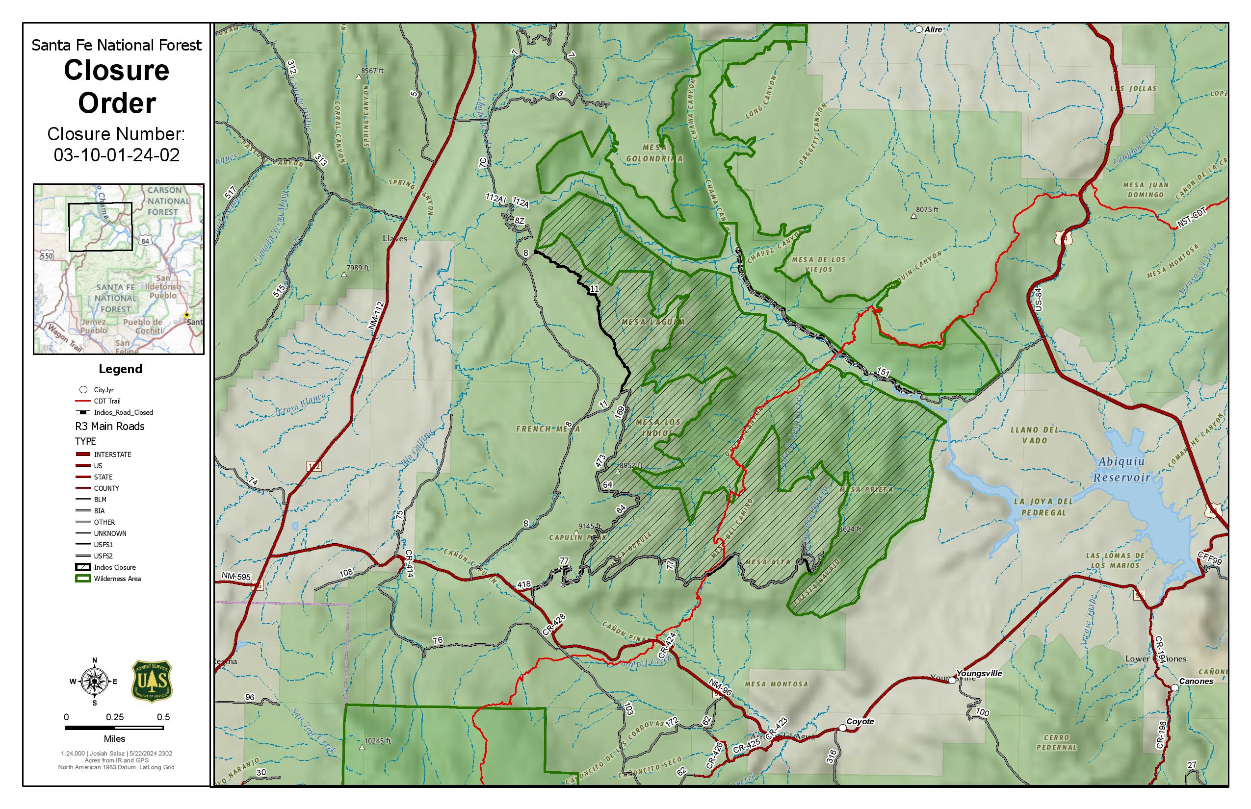
The Described Areas are within Township 23 North, Range 1 East, Sec. 13; Township 23 North, Range 2 East. Sec. 1-13; Township 23 North, Range 3 East. Sec. 2-10, 15-18. Township 24 North, Range 2 East sec. 1-6, 8-12, 13-17, 20-36; Township 25 North, Range 3 East, Sec. 7-9, 13-36. Township 25 North, Range 1 East sec. 13, 24; Township 25 North, Range 2 East, Sec. 19, 20, 27-30, 31-36.
Specifically, the Described Area includes all National Forest System lands within the boundary of the Coyote Ranger Districttsarting from the Continental Divide trail #298 at Highway 96 going north across Forest Road 77, through the Chama River Canyon Wilderness to Skull Bridge (Ojitos Trail head) on Forest Road 151. Order Number: 03-10-01-24-02
Forest Road 11 northwest to the Chama River Canyon Wilderness boundary and Junction with Forest Road 8; Forest Road 169 (from junction with Forest Road 11) south to Forest Road 473; Forest Road 473 south to Forest Road 64; Forest Road 64 South to the junction of Forest Road 77; and Forest Road 77 east to the Chama River Canyon Wilderness boundary. Forest Road 77 from the Forest boundary and County Road 418 to the junction of Forest Road 64 and Forest Road 77. The Chama River Canyon Wilderness south of Rio Gallina and south of Rio Chama.
Temporary Flight Restriction 05 23 2024
Related Incident: Blue 2 Fire
Publication Type: Closures
As of 1030 on March 23, 2024 , there is a temporary flight restriction above portions of the White Mountain Wilderness area. These restrictions are necessary to ensure firefighter & public safety by keeping the skies clear for emergency personnel. Help us in our efforts by watching the video attached on drone safety, and remember, if you fly we can’t.

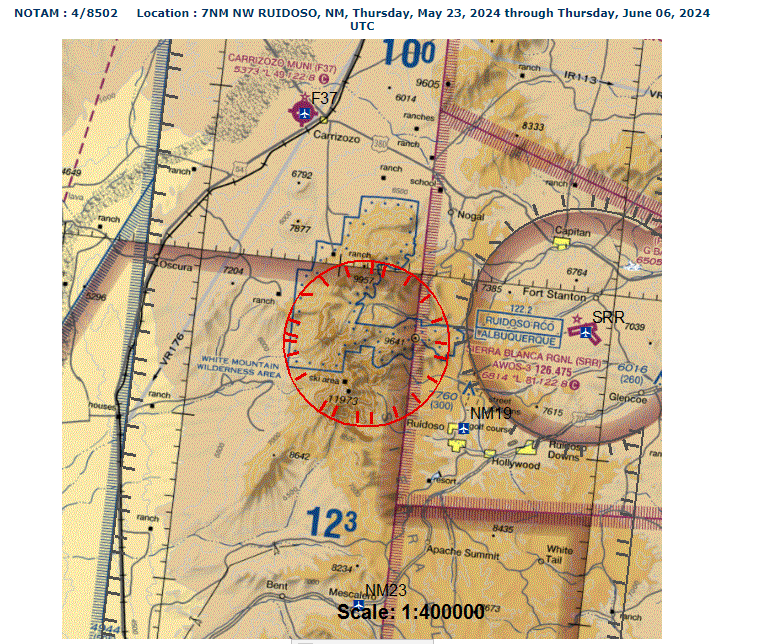
https://tfr.faa.gov/save_pages/detail_4_8502.html
Blue Fire Morning Update, May 23, 2024 05 23 2024
Related Incident: Blue 2 Fire
Publication Type: News
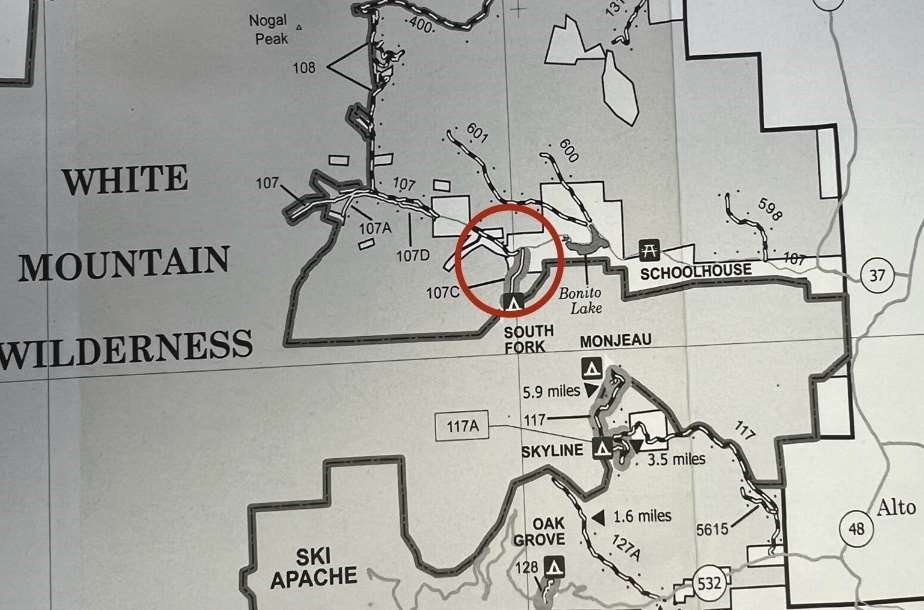
Update: The Blue fire continues to burn in a remote area of the White Mountain Wilderness. Crews are assessing existing trails to determine their suitability as containment lines. While crews work in the area, a closure order is in effect to ensure their safety. This area closure includes portions of the 107 Road on forest lands, including 107C, the South Fork Campground, and portions of 107 that are west of 107C.Light smoke may be visible, but significant impacts to the community are not currently expected
Close up of 107 Area Closure:

Start Date / Time: May 17, 2024, approximately 3:45 p.m.
Cause: Lightning
Size: Blue Fire:.5 acres Blue 2 Fire: 48 acres Location: White Mountain Wilderness Resources: 48 Personnel
Types of vegetation in the area (aka fuels): Dead and dead/down trees
Containment: 0%
Tactic: Full Suppression
Road Closures: 107 On Forest Land
Smoke: Light
Evacuations: None
Area Closures: Part of White Mountain Wilderness Area, See link for more information: https://inciweb.wildfire.gov/incident-publication/nmlnf-blue-2-fire/-closure-update-for-trails-on- white-mountain-wilderness-area-05-22-2024
More Information:
Facebook: www.facebook.com/LincolnNationalForest NM Fire Info: www.NMFireInfo.com
Spruce Creek Fire Update 05 23 2024
Related Incident:
Publication Type: News
Fire start date: May 14, 2024
Fire size today: 4,962 acres
Location: 11 miles Northeast of Dolores, CO on Haycamp Mesa
Personnel: 179
Cause: Lightning
Evacuation Information:
There are no current evacuations.
Fire Area and Roads Closure:
https://inciweb.wildfire.gov/incident-information/cosjf-2024-spruce-creek-co
Latest Smoke Outlook:
https://fire.airnow.gov/?aqi_v=2&m_ids=&pa_ids=%23
INCIDENT OBJECTIVES:
• Provide for firefighter and public safety throughout all phases of the incident
• Manage hazards to responders and the public using a risk-based approach to decision-making on a continual basis
• Protect critical values at risk
• Reduce the long-term risk to communities from future wildfire events
YESTERDAY’S OPERATIONS:
• Firefighters continued securing the western and eastern indirect fire boundaries (Forest Roads 556 and 557) using unmanned aerial systems (drones) and drip torches.
• Conditions were favorable for burnout operations to remove unburned fuel such as pine needles, gambel oak and dead and downed trees within pre-identified containment features.
TODAY’S PLAN:
• Fire managers plan to use one aerial ignition team and ground crews to secure the remaining previously defined indirect boundaries along natural features and existing roads. These indirect tactics have been determined to be the best approach to both containing the fire and reducing long-term fire risk to area communities.
• Once burnout operations are complete on the fire, crews will continue securing and improving fireline.
• Smoke will likely be very visible throughout the area, and may settle into valleys and other low-lying areas, especially at night and in the early morning hours. Wildfire smoke may affect your health. For more information, please go to: https://www.colorado.gov/pacific/cdphe/wood-smoke-and-health
WEATHER:
• Thursday will have similar temperatures and relative humidity as Wednesday. A frontal passage is expected toward late evening, resulting in slightly higher afternoon winds. Cloud cover will increase in the afternoon.
Wildcat Fire Update 05 23 2024
Related Incident: Wildcat Fire
Publication Type: News
Highlights: The Wildcat Fire footprint remains the same size as Wednesday. Fire crews are still assisting in
maintaining fire suppression. Their efforts resulted in zero fire growth on Wednesday.
Operations: Fire crews are continuing to scout, patrol, and monitor the Wildcat Fire to prevent any further spreading. The public is cautioned to be aware of their surroundings in order to drive safely through the areas active with firefighters and emergency vehicles.
Weather: Warmer conditions and low relative humidity will persist for the next several days. Southwest winds
are expected to gust up to 20 miles per hour in the afternoon. The winds are expected to lessen in the evening.
Closures and Restrictions: The Tonto National Forest is scheduled to begin Emergency Stage 1 Fire Restrictions on Thursday morning at 8 a.m. The restrictions will be in effect for the protection of public health and safety. The restrictions and closure orders are available on the Tonto National Forest website at https://www.fs.usda.gov/alerts/tonto/alerts-notices/?aid=87558
Safety: The health and safety of firefighters and the public are always the highest priority. Please avoid areas with crews conducting active fire suppression operations. The public is urged to sign up for the Maricopa County Emergency Notification System. The system allows you to be quickly notified of possible emergency evacuations. To learn more about the Arizona Emergency Information Network visit: https://ein.az.gov/ready-set-go.
Smoke: Smoke from the Wildcat Fire may be visible in the surrounding areas for many days. Smoke will drift to the north and east due to prevailing winds. Individuals who are sensitive to smoke and people with heart disease are encouraged to take precautionary measures. An interactive smoke map at https://fire.airnow.gov/ allows you to zoom into your area to see the latest smoke conditions.
Location: East of the Desert Mountain Community and Tonto Hills Development; West of Bartlett Lake Reservoir in the Cave Creek Ranger District.
Start Date: May 18, 2024
Size: Approximately 14,402 acres
Percent Contained: 56%
Cause: Under investigation.
Vegetation: The fire continues to burn grass and brush.
Resources: 2 crews, 7 fire engines, and 2 water tenders.
Number of Personnel Assigned: 109
Information Links and Contacts:
Tonto National Forest https://www.fs.usda.gov/main/tonto/fire
InciWeb https://inciweb.wildfire.gov/incident-information/aztnf-wildcat-fire
Fire email 2024.wildcat@firenet.gov
Information Phone: (480) 608-2181