
Blue 2 Fire Evening Update, May 25, 2024 05 26 2024
Related Incident: Blue 2 Fire
Publication Type: News
Start Date / Time: May 17, 2024, approximately 3:45 p.m.
Cause: Lightning
Size: Blue 2 Fire: 3,249 acres
Location: White Mountain Wilderness
Resources: 259 Personnel, more enroute
Vegetation/Fuels: Dead and dead/down trees
Containment: 0%
Tactic: Full Suppression
Smoke: Moderate / Wind Influenced Smoke
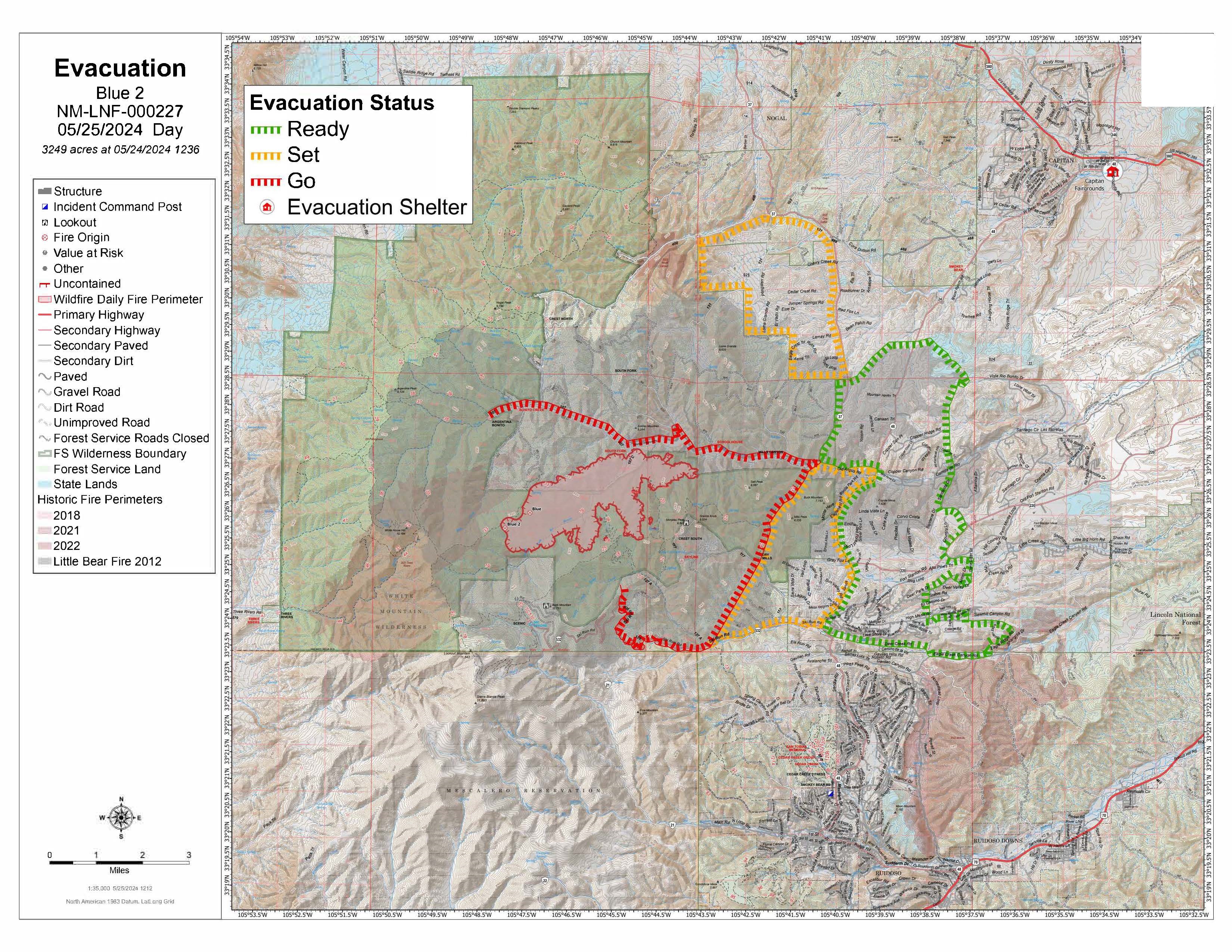
Evacuation: Go Now: Loma Grande, Bonito Lake Road, Forest Service Road 108, Forest Service Road 107, Villa Madonna Subdivision, Forest Service Road 127A, also known as Upper Eagle Creek off of ski run road and surrounding area along 523 Ski Run Road
Be Set: Sierra Vista Subdivision, Sun Valley Subdivision, Angus Communities West of NM 48 East of NM 37, Ski Run Road, Alto Area, Eagle Creek Sports Complex, Cora Dutton Area.
Be Ready: East of Enchanted Loop Communities, North towards Nogal, Village of Capitan.
Update: As of today, there have been no lives or structures lost. Today’s full suppression tactics consisted of ground operations with a focus on scouting control lines and beginning the construction of containment lines. The Albuquerque type three zone team will transition leadership to the Complex Incident Management Team 3 with Matt Rau assuming incident command. High winds hindered aerial operations today. Current acreage numbers were provided by an infrared flight flown May 24. Smoke continues to be visible in the populated areas of Ruidoso and Capitan. The same weather pattern is expected for the next operational period. A red flag warning was issued for the fire this afternoon, and it is expected to extend through the weekend.
Shelters: Lincoln County Fairgrounds / 101 5th St. Capitan NM 88316
Animal Shelters: Humane Society of Lincoln County / 25962 US Hwy 70 Ruidoso NM 88345
Area Closures: Part of White Mountain Wilderness Area, See link for more information: https://inciweb.wildfire.gov/incident-publication/nmlnf-blue-2-fire/-closure-update-for-trails-on-white-mountain-wilderness-area-05-22-2024
More Information:
Facebook: www.facebook.com/LincolnNationalForest
NM Fire Info: www.NMFireInfo.com
InciWeb: https://inciweb.wildfire.gov/incident-information/nmlnf-blue-2-fire
Lincoln County CodeRed: message “lincolnnmalerts” to 99411
New Closure Order Map: https://www.fs.usda.gov/alerts/lincoln/alerts-notices


EVACUATION MESSAGE: This is a GO MESSAGE Immediate Evacuation of Nogal Canyon RD. Please go the Fairgrounds at 101 5th in Capitan for shelter. DO NOT DELAY. 05 25 2024
Related Incident: Blue 2 Fire
Publication Type: Announcement
From Lincoln County Fire Service "!!EVACUATION MESSAGE!!:
This is a GO MESSAGE Immediate Evacuation of Nogal Canyon RD.
Please go the Fairgrounds at 101 5th in Capitan for shelter.
DO NOT DELAY."


Evacuation Information
Lincoln County Evacuation Information & Sign Up for CODERED
Lincoln County Fire Service Facebook
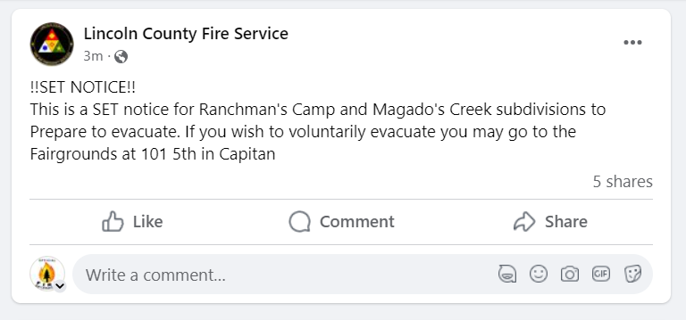
SET NOTICE This is a SET notice for Ranchman's Camp and Magado's Creek subdivisions to Prepare to evacuate. If you wish to voluntarily evacuate you may go to the Fairgrounds at 101 5th in Capitan 05 25 2024
Related Incident: Blue 2 Fire
Publication Type: Announcement
From Lincoln County Fire Service
!!SET NOTICE!!
This is a SET notice for Ranchman's Camp and Magado's Creek subdivisions to Prepare to evacuate. If you wish to voluntarily evacuate you may go to the Fairgrounds at 101 5th in Capitan

Evacuation Information
Lincoln County Evacuation Information & Sign Up for CODERED
Lincoln County Fire Service Facebook
EVACUATION NOTICE Residents of the LOMA GRANDE subdivision You are a GO to evacuate immediately 05 25 2024
Related Incident: Blue 2 Fire
Publication Type: Announcement
From Lincoln County Fire Service EVACUATION NOTICE
Residents of the LOMA GRANDE subdivision You are a GO to evacuate immediately. Do not delay leaving to gather any belongings. Please go the Fair Grounds at 101 5th in Capitan. Travel safely and follow instructions of Law Enforcement


Evacuation Information
Lincoln County Evacuation Information & Sign Up for CODERED
Lincoln County Fire Service Facebook
You Are Invited to a Town Hall May 25th at 07:00 p.m. 05 25 2024
Related Incident: Blue 2 Fire
Publication Type: Announcement

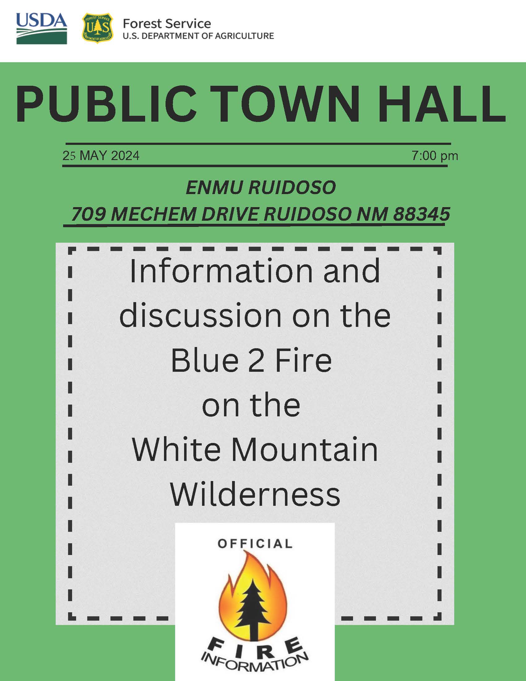
There will be a #blue2fire Town Hall tonight, May 25, 2024 at 7:00 pm. The meeting will be held at the Eastern New Mexico University-Ruidoso Branch Community College 709 Mechem Drive, Ruidoso NM.
Blue Fires 2024 Incident Page Facebook
https://www.facebook.com/Blue2Fire
EVACUATION INFORMATION
Lincoln County Evacuation Information & Sign Up for CODERED
https://www.lincolncountynm.gov/news_detail_T2_R25.php
Lincoln County Fire Service Facebook https://www.facebook.com/lincolncountyfireservice
Lincoln County Sheriff's Office Facebook https://www.facebook.com/lcsonm
Village of Ruidoso - Sign up for Emergency Notifications https://www.ruidoso-nm.gov/blue-2-fire
!!EVACUATION NOTICE!! Villa Madonna Subdivision needs to evacuate immediatel 05 25 2024
Related Incident: Blue 2 Fire
Publication Type: Announcement
From Lincoln County Office of Emergency Services: "!!EVACUATION NOTICE!!
Villa Madonna Subdivision needs to evacuate immediately to County Fairgrounds at Capitan. Please travel safely, follow directions of Law Enforcement
Lincoln County Office of Emergency Services"

Evacuation Information
Lincoln County Evacuation Information & Sign Up for CODERED
Lincoln County Fire Service Facebook
Evacuation Status Map May 25, 2024 05 25 2024
Related Incident: Blue 2 Fire
Publication Type: Announcement

Evacuation Information
Lincoln County Evacuation Information & Sign Up for CODERED
Lincoln County Fire Service Facebook
Daily Update: 05 25 2024
Related Incident: Indios Wildfire
Publication Type: News
Acres: 2345
Start Date: 5/19/2024
Location: 7 miles north of the village of Coyote, N.M.
Personnel: 195
Containment: 0%
Fuels: Timber, litter, understory
Resources: 5 crews | 1 helicopter | 5 engines| 1 road grader | 2 masticators | 1 water tender
Highlights: Fire information staff will be posted across the street from Bode’s near the Post Office in Abiquiu on Saturday, Sunday, and Monday (May 25-27) from 12-1 p.m. to meet with members of the public and answer questions.
The Southwest Area Complex Incident Management Team 4, Incident Commander Aaron Hulburd, will be in-briefed this afternoon to assume command of the fire on Monday, May 27. A CIMT comes with additional resources necessary to plan and manage this fire's long-term duration to meet the intent of letting fire play its natural role on the landscape.
Fire Activity: Yesterday, on the northeast side where it spotted into the 2017 Ojitos Fire area on Wednesday, the Sacramento and Black Mesa Interagency Hotshot crews worked to get an anchor point established. The crews used helicopters for water drops to cool the fire’s edge and tied the fireline into natural holding features. The Black Mesa crew conducted some strategic firing operations to create blackline, removing fuels from between the fire’s edge and the firelines. These crews will continue firing operations east to west to create a good line south of the fire.
The western edge of the fire from the handline on the northwest perimeter to where crews conducted firing operations along FR 473 Wednesday is holding. The Santa Fe, Mount Taylor, and Carson IHCs continued prepping along FR 437 to FR 64, including conducting strategic firing operations to a checkline. Two masticators continued making progress on lines west of the fire. The Sandia Helitack crew worked on prepping range infrastructure and USFS kiosks south of the fire.
Weather: A Red Flag Warning is in effect today from 11 a.m. to 9 p.m. Dry weather and strong winds are expected. The high temperature will be around 70 degrees, with minimum humidity around 11-16 percent. Winds will be southwest at 7-16 mph, shifting to west at 18-23 mph in the afternoon with gusts to 40 mph.
Smoke: Smoke is visible and local communities may experience smoke impacts along Highways 96, 112, and 84.
Closures: Closure Order 03-10-01-24-02 is in place and includes all National Forest System lands within the boundary of the Coyote Ranger District starting from the Continental Divide trail #298 at Highway 96 going north across Forest Road (FR) 77, through the Chama River Canyon Wilderness to Skull Bridge (Ojitos Trail head) on FR 151. FR 11 northwest to the Chama River Canyon Wilderness boundary and Junction with FR 8; FR 169 (from junction with FR 11) south to FR 473; FR 473 south to FR 64; FR 64 South to the junction of FR 77; and FR 77 east to the Chama River Canyon Wilderness boundary. FR 77 from the Forest boundary and County Road 418 to the junction of FR 64 and FR 77. The Chama River Canyon Wilderness south of Rio Gallina and south of Rio Chama. Visit Inciweb for the full order and map.
For CDT hikers impacted by this closure, camping and water will be available at the Coyote Ranger Station.
Temporary Flight Restrictions: There is a TFR in place around the fire area.
More Information: 575-323-2290 | 2024.indios@firenet.gov | x.com/SantafeNF
facebook.com/santafeNF | inciweb.wildfire.gov/incident-information/nmsnf-indios-wildfire
Blue 2 Fire Morning Update, May 25, 2024 05 25 2024
Related Incident: Blue 2 Fire
Publication Type: News
Blue 2 Fire Morning Update, May 25, 2024
Update: As a proactive precaution, Lincoln County Emergency Services has issued a new Emergency Evacuation for the Villa Madonna Subdivision. Go is also issued for area off Forest Service Road 127A, also known as Upper Eagle Creek, off of Ski Run road and surrounding area along 523 Ski Run road & Eagle Creek Sports Complex. Please evacuate to the Capitan Fairgrounds Shelter. For more information, please contact the Emergency Contact Center: (575) 336-8600.
LOCATIONS IN “SET” include: Sierra Vista & Sun Valley Subdivisions, All Ski Run Road, The Alto Area & The Community of Angus.
LOCATIONS IN “READY” include: Enchanted Loop Community and areas East and North of the community.
Please note this is a fluid situation and boundaries for ready, set, go are changing. Updated map of locations to come as soon as possible. Emergency Management Services are issuing non-opt in alerts to people in the “GO” area. You can hear more information on 1490 AM station.
Recreation, sporting events, and tourism occurring in the area should heed the warnings set by the county.
“As a precautionary measure, a command decision was made to engage early in safety evacuations. We will continue to be proactive while in command of this incident.” -Incident Commander, Lino Baca.
Wind is expected to be a large factor in fire growth, with high winds and gusts predicted in the fire area. Today’s mission focused on air and ground operations. Red Flag Warning & Wind Advisory is in effect for the Village of Ruidoso for today, May 25, 2024, until 10:00 PM. The Southwest Complex Incident Team is enroute and will transition Sunday.
There is a new closure order issued by the Lincoln National Forest, Smokey Bear District. The restricted area is National Forest System lands, roads, and trails within and around the Smokey Bear District on the Lincoln National Forest. The western boundary of the Restricted Area is located at the junction of National Forest Service Road (NFSR) 400 and NFSR 108 Tanbark, NFSR 108 Tanbark to NFSR 107, NFSR 107 to Big Bonito trail #36 to the junction of Aspen Trail # 35, Aspen Trial #35 to the junction of Crest Trail #25, Crest Trail #25 to the junction of Trail # 78, Trail #78 to the Forest Boundary. The Southern boundary is the Forest Boundary from trail # 78 going east for approximately 4.75 miles, then due north for approximately 1/10 of a mile to road 532, road 532 east to the Forest Service Boundary. The eastern boundary is the Forest Service Boundary due north approximately 9 miles north to NFSR 400. The northern boundary is NFSR 400 west to the junction of NFSR 108 Tanbark Canyon, the junction of Rodamaker Trail # 20 along NFSR 107 to the Big Bonito trail #36. The purpose of this Order is to protect the safety of firefighter personnel and the public as firefighters engage in suppression tactics on the Blue 2 wildfire.
This Order shall be in effect from May 23, 2024, at 12:01 a.m. through 23 August 2024, at 12:01 p.m., unless rescinded. 2. A map identifying the Described Area is linked below.
Lincoln County has declared a state of disaster to ensure resource availability. Lincoln County Fire Service advises citizens to sign up for CodeRed (see link below) even if you are not impacted by this fire, it is an important resource for local residents.
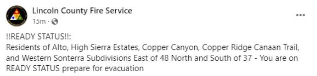
Current Evacuations issued by the Lincoln County Sheriff’s Office are under effect for Villa Madonna Subdivision, Bonito Lake Rd, Forest Service Road 108, and Forest Service Road 107. At this time, the Angus Area, Sierra Vista & Sun Valley subdivisions on the west side of Hwy48 should also be ready for evacuations.
Please keep 911 open and available for emergencies.
The public townhall meeting has been added to our incident Facebook page. And another is scheduled for tonight at 7 PM.
Start Date / Time: May 17, 2024, approximately 3:45 p.m.
Cause: Lightning
Size: Blue 2 Fire: 3,427 acres
Location: White Mountain Wilderness
Resources: 177 Personnel, more EnRoute
Vegetation/Fuels: Dead and dead/down trees
Containment: 0%
Tactic: Full Suppression
Smoke: Moderate / Wind Influenced Smoke
Evacuation:
Go Now: Bonito Lake Road, Forest Service Road 108, Forest Service Road 107, Villa Madonna Subdivision, Forest Service Road 127A, also known as Upper Eagle Creek off of ski run road and surrounding area along 523 Ski Run Road, Eagle Creek Ball Fields,
Be Set: Sierra Vista Subdivision, Sun Valley Subdivision, Angus Communities, Ski Run Road, Alto Area,
Be Ready: East of Enchanted Loop Communities, North towards Nogal
Shelters: Lincoln County Fairgrounds / 101 5th St. Capitan NM 88316
Animal Shelters: Humane Society of Lincoln County / 25962 US Hwy 70 Ruidoso NM 88345
Area Closures: Part of White Mountain Wilderness Area, See link for more information: https://inciweb.wildfire.gov/incident-publication/nmlnf-blue-2-fire/-closure-update-for-trails-on-white-mountain-wilderness-area-05-22-2024
More Information:
Facebook: www.facebook.com/LincolnNationalForest
NM Fire Info: www.NMFireInfo.com
InciWeb: https://inciweb.wildfire.gov/incident-information/nmlnf-blue-2-fire
Lincoln County CodeRed: message “lincolnnmalerts” to 99411
New Closure Order Map: https://www.fs.usda.gov/alerts/lincoln/alerts-notices
Spruce Creek Fire Update 05 25 2024
Related Incident:
Publication Type: News
Fire start date: May 14, 2024
Fire size today: 5,699 acres
Location: 11 miles Northeast of Dolores, CO on Haycamp Mesa
Personnel: 168
Cause: Lightning
Containment: 43%
Evacuation Information: There are no current evacuations.
Fire Area and Roads Closure:
https://inciweb.wildfire.gov/incident-information/cosjf-2024-spruce-creek-co
Latest Smoke Outlook:
https://fire.airnow.gov/?aqi_v=2&m_ids=&pa_ids=%23
INCIDENT OBJECTIVES:
Provide for firefighter and public safety throughout all phases of the incident
Manage hazards to responders and the public using a risk-based approach to decision-making on a continual basis
Protect critical values at risk
Reduce the long-term risk to communities from future wildfire events
YESTERDAY’S OPERATIONS:
Firefighters patrolled the perimeter of the fire area, taking actions where needed to further-secure the firelines. In the interior, the fire continued to consume stumps, brush and other ground fuels.
TODAY’S PLAN:
Crews will continue their patrols and extinguish any hot spots that could potentially threaten the firelines.
Interior pockets of unburned fuel, such as pine needles, Gambel oak and dead and downed trees, are expected to continue to smolder and burn.
A dozer and a grader have been brought up to repair roads impacted by firefighting operations.
Smoke may be visible in the area and it may settle into valleys and other low-lying areas, especially at night and in the early morning hours. Wildfire smoke may affect your health. For more information, please go to: https://www.colorado.gov/pacific/cdphe/wood-smoke-and-health
WEATHER:
A low-pressure system moving into the area on Saturday will bring an increase in winds, higher humidity and a chance of showers. The high temperature will be around 60.