
Wildcat Fire Update05 21 2024
Related Incident: Wildcat Fire
Publication Type: News
Highlights: Good progress was made by firefighters on the Wildcat Fire on Sunday night and Monday. Containment increased from 0% to 23% during the period. The fire size increased minimally to 14,283 acres due to the efforts of firefighters. A cold front passing through the region also helped containment efforts. Grasses that the firefighters are encountering are so high they are hard to walk through. Higher grass could challenge them while conducting suppression activities.
Operations: Although the fire was less intense Monday, firefighters were able to make progress, however, temperatures are predicted to rise to near 90 degrees on Tuesday with relative humidity falling to nearly 10%. This combination along with possible 20 mile per hour wind gusts in the afternoon may increase the chances of the fire increasing in intensity.
Weather: Hot, windy, and dry conditions will persist for the next several days. South winds are expected to gust up to 20 miles per hour during the afternoon. This could make fire suppression efforts more difficult. The winds are forecasted to lessen in the evening.
Closures: A larger closure order is in effect for the protection of public health and safety due to firefighting operations.Bartlett Lake Road remains closed. The public is requested to stay away from the area. This is for the safety of the public and firefighters. The closure order is available on the Tonto National Forest website by going to: https://www.fs.usda.gov/alerts/tonto/alerts-notices/?aid=87558
Safety: The health and safety of firefighters and the public are always the highest priority. Please avoid the area while crews conduct fire suppression. Citizens are urged to sign up for the Maricopa County Emergency Notification System. The system allows you to be quickly notified of emergency evacuations. To learn more about the Arizona Emergency Information Network visit: https://ein.az.gov/ready-set-go. Firefighting aircraft and drones are a dangerous combination. Drones in the area could lead to accidents or slow down wildfire suppression operations. If you fly…we can’t.
Smoke: Smoke from the Wildcat Fire has recently decreased, however it may be visible in the surrounding areas for many days. Smoke will drift to the north and east due to prevailing winds. Individuals who are sensitive to smoke and people with heart disease are encouraged to take precautionary measures. An interactive smoke map at https://fire.airnow.gov/ allows you to zoom into your area to see the latest smoke conditions.
Location: East of the Desert Mountain Community and Tonto Hills Development; West of Bartlett Lake Reservoir in the Cave Creek Ranger District.
Start Date: May 18, 2024
Size: Approximately 14,283 acres
Percent Contained: 23%
Cause: Under investigation.
Vegetation: The fire is burning grass and brush.
Resources: 9 crews, 21 fire engines, 4 helicopters, and 4 water tenders.
Number of Personnel Assigned: 318
Information Links and Contacts:
Tonto National Forest https://www.fs.usda.gov/main/tonto/fire
InciWeb https://inciweb.wildfire.gov/incident-information/aztnf-wildcat-fire
Fire email 2024.wildcat@firenet.gov Information Phone (480) 608-2181
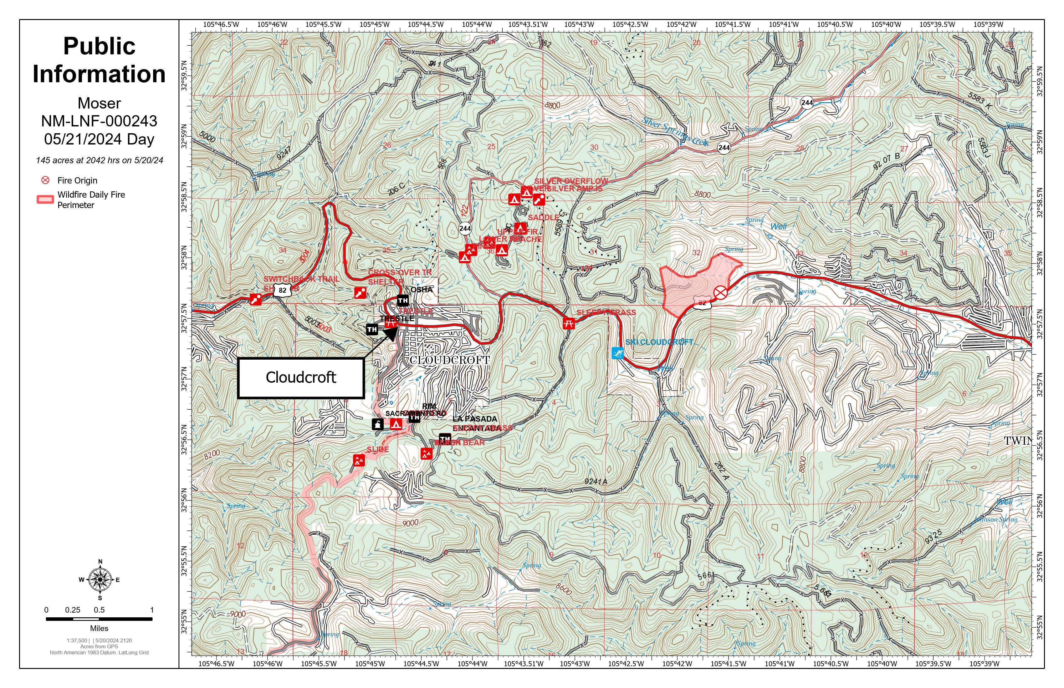
Moser Fire Morning Update, May 21, 2024: 05 21 2024
Related Incident:
Publication Type: News
Start Date / Time: May 20, 2024, approximately 3:45 p.m.
Cause: Unknown, Under Investigation
Size: 145 acres (Subject to change as more accurate mapping tool are deployed)
Location: 4 miles east of Cloudcroft
Resources: Firefighters from US Forest Service, Volunteer Fire Departments, BLM, State, 2-dozer, 1 helicopter, additional aviation resources (as needed)
Types of vegetation in the area (aka fuels): Mixed Conifer
Containment: 0%
Strategy: Full Suppression
Road Closures: Highway 82 remains closed from the upper junction of Highway 244 to Dry Canyon Road.
Smoke: Expect smoke to remain visible from Hwy 82, Cloudcroft and surrounding areas.
Evacuations: All evacuations remain in place. Fire and county officials will reevaluate the need for evacuations today.
GO Status: Areas from mile marker 21-23 on the north side of highway 82 are in mandatory GO status evacuations. This includes Alpine Rd., Hollywood Blvd., Pine Ridge Loop Rd., Wildwood Loop, and all roads connected to these main roads.
SET Status: Areas on the south side of Highway 82 from mile marker 21-23 are in SET evacuation status.
For reference the fire is located between mile marker 20-21. Review the national READY, SET, GO evacuation statuses at tinyurl.com/NMForestryREADYSETGO.
(Evacuations are being handled by Otero County, for updates visit www.facebook.com/people/Tularosa-Basin-Regional-Dispatch-Authority/100091541917115/15.)
Update: The Moser Fire remains at 0% contained this morning; however, containment lines built yesterday held overnight. Crews have built containment lines around approximately 80% of the fire. Containment numbers are expected to increase as fire officials continue securing the fire’s perimeter. Fire activity overnight was minimal due to lower temperatures and higher humidity levels.
Today crews will continue building direct fire containment lines around the remaining 20% of the fire. They will also be patrolling for any hotspots along the edge of the fire and laying over a mile of fire hose. Once the hoses are in place, water will be pumped to the fire and crews will begin to extinguish hotspots and work their way towards the interior of the fire.
Donations: Thankfully our firefighters are being well taken care of. Right now, the only donations needed is water or Gatorade, which can be dropped off at the Cloudcroft Fire Department at 1100 James Canyon Highway, Cloudcroft, NM. Thank you to the local businesses who have provided support to the firefighters and evacuees.
More Information:
Facebook: www.facebook.com/LincolnNationalForest
NM Fire Info: www.NMFireInfo.com
You can expect another update tonight, May 21, 2024.
Spruce Creek Fire Update 05 21 2024
Related Incident:
Publication Type: News
Fire start date: May 14, 2024
Fire size today: 1,644 acres
Location: 11 miles Northeast of Dolores, CO on Haycamp Mesa
Personnel: 118
Cause: Lightning
Evacuation Information:
There are no current evacuations.
Closures:
Fire Area and Roads Closure:
https://inciweb.wildfire.gov/incident-information/cosjf-2024-spruce-creek-co
Latest Smoke Outlook:
https://fire.airnow.gov/?aqi_v=2&m_ids=&pa_ids=%23
INCIDENT OBJECTIVES:
- Provide for firefighter and public safety throughout all phases of the incident
- Manage hazards to responders and the public using a risk-based approach to decision-making on a continual basis
- Protect critical values at risk
- Reduce the long-term risk to communities from future wildfire events
YESTERDAY’S ACCOMPLISHMENTS:
- Firefighters were able to secure an additional ½ mile of indirect line along the western edge of the fire area, using hand and aerial ignitions.
- Crews also made progress in efforts to protect fences and corrals located near the fire.
TODAY’S PLAN:
- San Juan Type 3 incident Management Team (IMT) assumed fire command at 6am today, May 21th. Pat Seekins is serving as incident commander.
- As weather conditions allow, firefighters will continue to use drones and hand ignitions to further-secure pre-identified boundaries along natural features and existing roads in order to suppress the fire and reduce long-term fire risk in the area.
- A closure order is now in effect for the fire area. This includes several Forest Service roads within and along the boundaries of the fire area.
WEATHER:
- A cold front will move through the area around mid-afternoon, with breezy winds, a 30-40% chance for showers, and slight 10% chance of storms. Winds by any storms could produce gusts up to 40 mph. Much cooler conditions in store for Wednesday, with dry conditions and lighter southwest afternoon winds.
- Smoke will continue to be visible throughout the area, and may settle into valleys and other low-lying areas, especially at night and in the early morning hours. Wildfire smoke may affect your health. For more information, please go to: https://www.colorado.gov/pacific/cdphe/wood-smoke-and-health
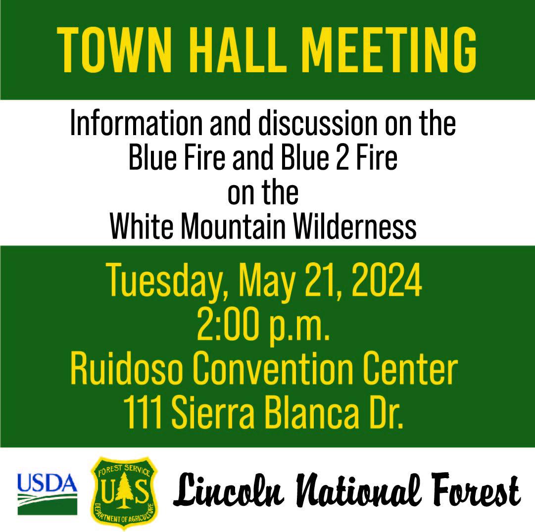
Town Hall meeting Tuesday, May 21, at 2:00 p.m 05 21 2024
Related Incident: Blue 2 Fire
Publication Type: Announcement
We will be hosting a Town Hall meeting Tuesday, May 21, at 2:00 p.m., to discuss the #Blue2Fire
Ruidosos Convention Center, 111 Sierra Blanca Dr, Ruidosos, NM
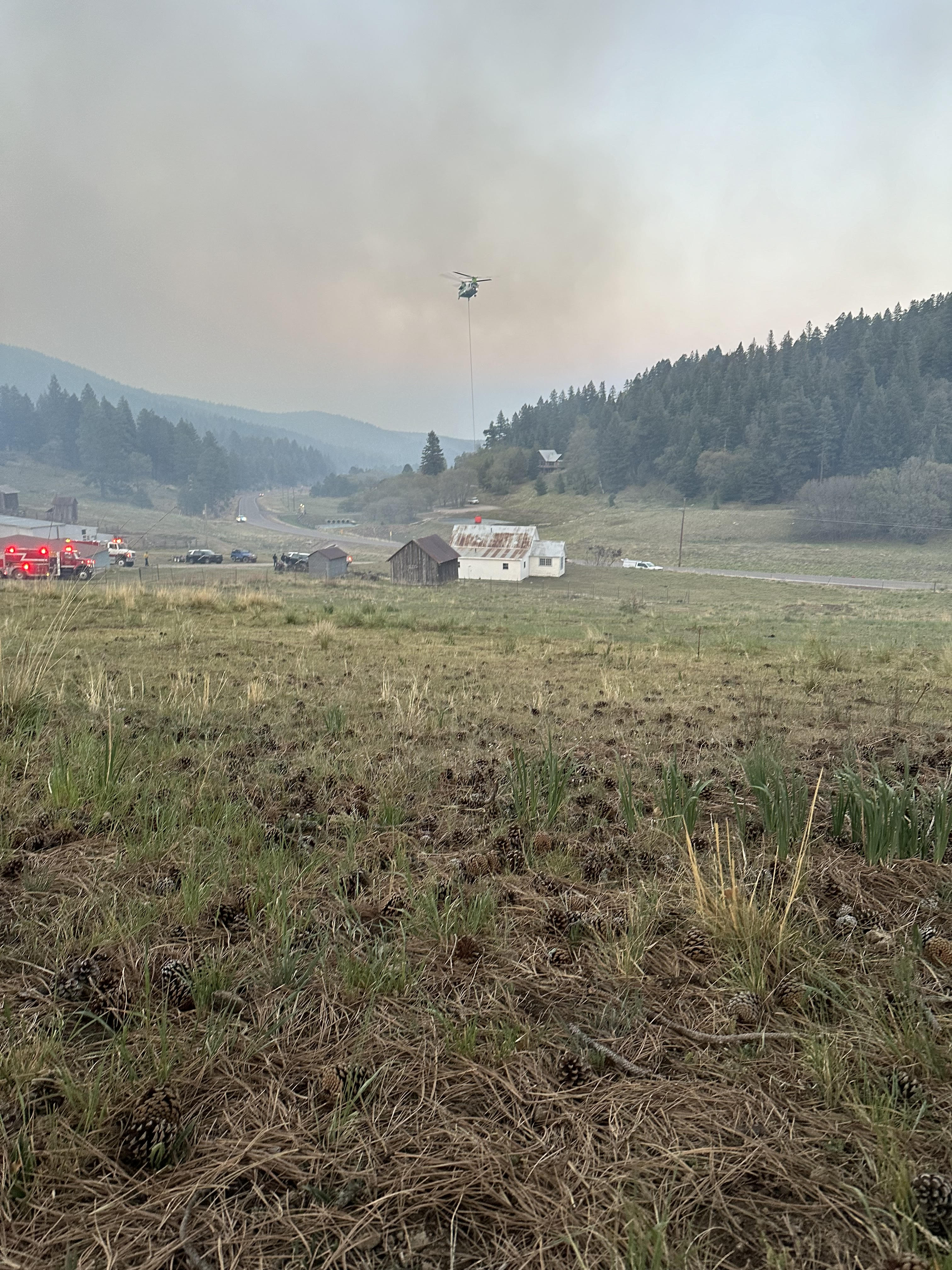
Moser Fire Evening Update May 20, 2024: 05 21 2024
Related Incident:
Publication Type: News
Start Date / Time: May 20, 2024, approximately 3:45 p.m.
Cause: Unknown, Under Investigation
Size: 145 acres (Subject to change as more accurate mapping tool are deployed)
Location: 4 miles east of Cloudcroft
Resources: Firefighters from US Forest Service, Volunteer Fire Departments, BLM, State, 2-dozer, 3 large airtankers, 2 very large airtankers, 1 air attack, 1 helicopter.
Types of vegetation in the area (aka fuels): Mixed Conifer
Containment: 0%
Strategy: Full Suppression
Road Closures: Highway 82 is closed from the upper junction of Highway 244 to Dry Canyon Road.
Smoke: Moderate
Evacuations:
GO Status: Areas from mile marker 21-23 on the north side of highway 82 are in mandatory GO status evacuations. This includes Alpine Rd., Hollywood Blvd., Pine Ridge Loop Rd., Wildwood Loop, and all roads connected to these main roads.
SET Status: Areas on the south side of Highway 82 from mile marker 21-23 are in SET evacuation status.
For reference the fire is located between mile marker 20-21. Review the national READY, SET, GO evacuation statuses at tinyurl.com/NMForestryREADYSETGO.
(Evacuations are being handled by Otero County, for updates visit www.facebook.com/people/Tularosa-Basin-Regional-Dispatch-Authority/100091541917115/15.)
Update: The Moser Fire started around 3:45 pm today off the side of Highway 82, four miles east of Cloudcroft. The fire began moving uphill in mixed conifer forest. Gusty winds created several spot fires ahead of the main fire. Firefighters from multiple agencies quickly responded to the fire. Firefighting crews and heavy equipment, including 2 bull dozers, are constructing direct fire line on the south, southwest and western sides of the fire and will continue to work their way to the north. Three large airtankers, two very large air tankers, and a helicopter dropped several loads of fire retardant and water. These aviation resources will remain available tomorrow as needed. Fire activity has decreased from the initial start and is now moving across the forest floor. The cause of the fire is unknown and under investigation. There are no injuries or fatalities. Thank you to the community for your support and willingness to help.
More Information:
Facebook: www.facebook.com/LincolnNationalForest
NM Fire Info: www.NMFireInfo.com
You can expect another update mid-morning tomorrow, May 21, 2024.
Spruce Creek Fire Area and Road Closures 05 21 2024
Related Incident:
Publication Type: Closures
The San Juan National Forest has issued a closure order for the Spruce Creek Fire area. This includes several National Forest Service roads where they are located within the described area, and where they border that area. The purpose of the closure is to protect public health and safety during the ongoing Spruce Creek Fire. A pdf version, including a map, can be downloaded using the link on this page under "Related Information". Additional information can be obtained at https://www.fs.usda.gov/alerts/sanjuan/alerts-notices
Evacuation Orders for the Moser Fire05 20 2024
Related Incident:
Publication Type: Announcement
Evacuations:
GO Status: Areas from mile marker 21-23 on the north side of highway 82 are in mandatory GO status evacuations. This includes Alpine Rd., Hollywood Blvd., Pine Ridge Loop Rd., Wildwood Loop, and all roads connected to these main roads.
SET Status: Areas on the south side of Highway 82 from mile marker 21-23 are in SET evacuation status.
Evacuation order will be reviewed later today to determine if and when orders will be lifted.
For reference the fire is located between mile marker 20-21. Review the national READY, SET, GO evacuation statuses at tinyurl.com/NMForestryREADYSETGO.
(Evacuations are being handled by Otero County, for updates visit www.facebook.com/people/Tularosa-Basin-Regional-Dispatch-Authority/100091541917115/15.)
Forsythe II Update 05 20 2024
Related Incident: Forsythe II Prescribed Burn
Publication Type: Announcement
Fire crews will remain at the Forsythe II Prescribed Burn Project Site working on securing the edge around the Unit 44A burn by spraying water, stirring dirt and utilizing sprinklers, for the next several days. There are no further ignitions planned for Forsythe II this spring. We plan to post additional information here with any notable updates, and will provide a final notification when Forsythe II is declared completely extinguished for the spring, meaning there is no heat left in the area. We have posted a new video under our "videos" tab covering this information.
Additional questions can be sent to ARPFireInfo@usda.gov.
New Wildfire Start in Coyote Ranger District Indios Wildfire 05 20 2024
Related Incident: Indios Wildfire
Publication Type: News
Santa Fe National Forest fire managers respond to Indios Fire
Santa Fe, N.M., May 20, 2024—Santa Fe National Forest (SFNF) fire managers were notified of a new wildfire start on Sunday, May 19, around noon in the Coyote Ranger District, located about 7 miles north of the village of Coyote, N.M within the Chama River Canyon Wilderness. A fire investigator will confirm the cause, but lightning was detected in the area. Firefighters were not able to safely engage the fire due to steep and inaccessible terrain. Firefighters have spent the last couple days scouting roads and gaining access to the fire area to locate potential control lines. The northern New Mexico Type 3 team has been ordered to manage the Indios Wildfire. Firefighter safety, protecting values at risk, and meeting the SFNF Land Management Plan for wildfires are the main objectives for the incident.
A helicopter flew over the fire perimeter Monday morning (May 20) and assessed the acreage at 150-200 acres. Resources on the wildfire include 1 helicopter, 3 engines, with additional resources on the way. The wildfire is most active on the northeast side burning within the Chama River Canyon Wilderness with currently no threats to people or property. Smoke may be visible in the area along State Road 96. There are potential impacts to some recreation sites within the Coyote Ranger District namely the Continental Divide Trail.
Fire managers are evaluating a variety of management strategies for the Indios Wildfire, which can range from full suppression to managing the fire to restore its natural role in the ecosystem while meeting resource objectives on the landscape. Wildfire management decisions are informed by several factors including firefighter safety, terrain, weather forecasts, past prescribed fire units and vegetation management projects in area, and threats to public safety and property. The fire is burning within the Rio Chama Collaborative Forest Landscape Restoration Project an ecosystem restoration project that spans 3.8 million acres of forested lands and multiple ownerships in Northern New Mexico and Southern Colorado. “Wildfires have the potential to decrease fuels and increase the health and resilience of forests. Fire is a natural and frequent component of the ecosystem in the area, and our team will look for opportunities to restore forest health when conditions permit,” said Forest Supervisor Shaun Sanchez.
Updates will be provided on the SFNF website, NM Fire Info, Inciweb, and SFNF social media pages (Facebook and X).
###
USDA is an equal opportunity provider, employer, and lender.
Settings - change map background and toggle additional layers
Filter - control incident types displayed on map.
Zoom to your location
Reset map zoom and position
Could not determine your location.
Show Legend
 Wildfire
 Prescribed Fire
 Burned Area
Response
Burned Area
Response Other
Other