
Wolf Fire operations wrap up following 10,000 acres of forest treatment 05 14 2024
Related Incident:
Publication Type: News
Wolf Fire operations wrap up following 10,000 acres of forest treatment
Coconino National Forest to continue holding fire perimeter
HAPPY JACK, Ariz., May 13, 2024 — Wolf Fire operations have resulted in the treatment of roughly 10,000 acres of land following a late April lightning strike on the Coconino National Forest’s Mogollon Rim Ranger District.
Fire managers spent roughly one week conducting firing operations to reduce dead vegetation and hazardous fuels, restore critical nearby watersheds, improve wildlife habitat and lessen the future risk of catastrophic wildfire in the Clints Well area.
“We’ve had really good fire effects with west winds pushing in over the last few days,” said Incident Commander (Trainee) Paul Oltrogge. “The weekend’s light rains moderated things nicely, and the effects of the Wolf Fire are already looking incredibly beneficial for the landscape.”
Firing operations wrapped up in advance of heavier predicted rains on Tuesday and Wednesday.
The Northern Arizona Type 3 Incident Management Team, which has been managing the Wolf Fire since May 6, plans to transition management of the fire back to the Coconino National Forest on Wednesday.
A closure order remains in place for the area surrounding the fire, as does a temporary flight restriction. Drone and aircraft operators are asked to abide by the issued restrictions.
Forest visitors can check the Coconino National Forest’s website at coconinonationalforest.us for updates regarding fire area closures.
There are roughly 150 personnel assigned to the 9,896-acre Wolf Fire, including two Hotshot crews, nine engines, one dozer, two water tenders and one hand crew.
Lightning-caused fires allow an opportunity for land treatment: The removal of forest fuels – such as pine needle accumulation, dead and down trees and other dry plant matter – that create hazardous conditions that could lead to potential catastrophic wildfire.
Land treatment using fire is an important part of the Forest Service’s 10-year Wildfire Crisis Strategy, which aims to reduce the risk of wildfire to critical infrastructure and communities.
As part of the overall Wildfire Crisis Strategy, the Coconino National Forest is committed to restoring land and protecting watersheds – including work on the Cragin Watershed Protection Project – as part of the wider Four Forest Restoration Initiative (4FRI).
This is the last scheduled news release regarding the Wolf Fire. For continued updates on the Wolf Fire, please visit inciweb.wildfire.gov, where fire updates will be posted until full fire containment.
May 14, 2024 Prescribed Fire Update 05 14 2024
Related Incident:
Publication Type: Announcement
Prescribed fire operations will continue today on the Hall Wood project on the Superior Ranger District, as weather and fuels conditions allow.
Superior Ranger District:
Firefighters will conduct up to 30 acres of prescribed fire operations on the Hall Wood project, located 2 miles north of Superior in the Flat Creek drainage. The purpose of the prescribed fire operations is to reduce the fuel loading created from previous management operations. Engines and firefighters will be utilizing Forest Service Roads 7872 and 7871, please use caution and slow down. Smoke will likely be seen from Superior.
Prescribed fire will be implemented in compliance with Montana air quality standards and coordinated with the Montana Department of Environmental Quality and the appropriate county health departments to minimize the impacts of smoke. Check air quality near you on the Fire and Smoke Map online at fire.airnow.gov.
Settings - change map background and toggle additional layers
Filter - control incident types displayed on map.
Zoom to your location
Reset map zoom and position
Could not determine your location.
Show Legend
 Wildfire
 Prescribed Fire
 Burned Area
Response
Burned Area
Response Other
Other
Toyo Fire
Unit Information
Incident Contacts
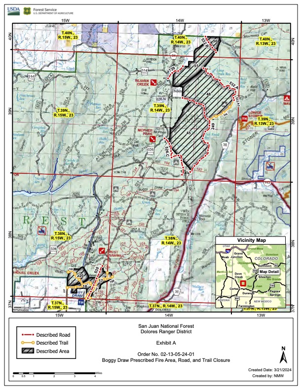
Boggy Draw Trails to Reopen Enter at Your Own Risk 05 13 2024
Related Incident: 2025 San Juan National Forest Prescribed Fire Program
Publication Type: Announcement
A Message from Your Dolores District Ranger
Let me start by saying “thank you” to everyone for your patience and cooperation with our prescribed fire in Boggy Draw last week. We were able to bring fire across over 1,100 acres in three burn units, including Little Bean Canyon, which has not seen any fire in many years. Having made significant efforts to mitigate prescribed fire related risks to the trails in the area, we will be opening the area to the public starting tomorrow Tuesday, (5/14). Expect to see smoke coming from within the burn units for the next few weeks, especially as the fuels dry out and temperatures warm up. Please do not report “smokes” inside the perimeter. We have personnel patrolling the area and will work to mitigate any remaining hazards near our unit boundaries. Frequent smoke report calls tie up our dispatchers and can delay response to developing emergencies. We will extinguish hot spots that could be a threat along the edge of the burn units but will allow fire to play its natural role within the interior.
Please remember that any post-fire landscape has hazards and can pose risks to recreationists (and pets). These hazards may include stump holes with hot ashes, unstable ground where roots have burned and fire-weakened trees. These hazards are not always obvious to the casual observer so, when in the area, enter at your own risk, and please keep your dogs leashed.
The Dolores Ranger District continues to look for favorable weather windows to further our spring prescribed fire program. These burns help make our forests more resilient and protect communities and infrastructure by eliminating hazardous fuel build-up. Low-to-moderate intensity burns, like the one last week, create spaces where firefighters can safely engage and stop future, high-severity fires, because fire behavior decreases when a wildfire reaches recently burned areas.
Please reach out and let us know if you have questions. You can get updates on prescribed fire, as well as general forest news, on our Facebook Page: https://www.facebook.com/sanjuannationalforest/ as well as here on Inciweb.
Thank you and let us know if you have questions or concerns.
Nicholas Mustoe
District Ranger
East Zone Roadside Underburn Update #3 05 13 2024
Related Incident:
Publication Type: Announcement
Ignitions were held yesterday, May 12 and will also be help today, May 13, 2024. Further ignitions on the East Zone Roadside Underburn may continue this week, conditions permitting.
Little Yamsay Fire Update May 13, 2024 05 13 2024
Related Incident: Little Yamsay Fire
Publication Type: News
Little Yamsay Fire Update - May 13, 2024
Fire Information: 971-978-7899
Email: 2024.littleyamsay@firenet.gov
Size: 6340 acres Location: 15 miles southeast of Chemult, OR near Klamath Marsh
Start Date: Detected April 20, 2024 Cause: Lightning Total Personnel: 102
Crews: 3 Engines: 5 Heavy Equipment: 1 Water Tenders: 3
This will be the final update from the type 3 IMT for the Little Yamsay Fire. Fire managers are anticipating a transition early this week from the type 3 incident management team (IMT) to a smaller type 4 IMT as resources are released.
Sunday saw the completion of phase three of firing treatments, with multiple hotshot crews and engines strategically bringing fire to the final corner on the southwest side of the control line perimeter. With phase three done, roughly 6000 acres of low-intensity firing operations were accomplished on the Little Yamsay Fire, helping to re-introduce a natural regime of fire to the landscape for fuels reduction and forest health benefits.
Fire managers will assess whether or not to complete phase four of firing operations this week. Smoke may linger for several days after firing operations have been completed and, within the perimeter of control lines, could be visible into the early summer. Firefighters will remain on scene well after firing operations are complete, patrolling control lines and monitoring smoke, and taking proactive measures to protect legacy pines and ensure fire does not cross control lines.
In combination with the Dillon Creek Fire from 2023, these treatments cover 10,000 acres along the Silver Lake Highway. This is 10,000 acres of forest that now has
Reduced chance of disease from insects
Enhanced nutrient content in the soil
Less competitive vegetation for the larger pines
Enhanced protection from large, destructive wildfires
Utilizing natural starts to re-introduce fire to the landscape, at the right place and the right time, is a shift in land management practice that is exceedingly important if we are to return the West’s forests to a level of health and resilience that can withstand drought, increasingly unpredictable and hot summers, and large fast-moving fires.
There are no closures or evacuations for the Little Yamsay Fire. Residents and visitors traveling to the area are encouraged to drive responsibly as emergency firefighter vehicles will be present. Expect delays as traffic control may be implemented due to smoke and/or hazards.
Facebook: https://www.facebook.com/SCOFMPFIREINFO
Inciweb: https://inciweb.wildfire.gov/incident-information/orfwf-little-yamsay-fire
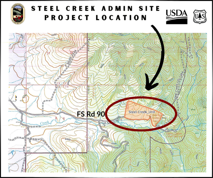
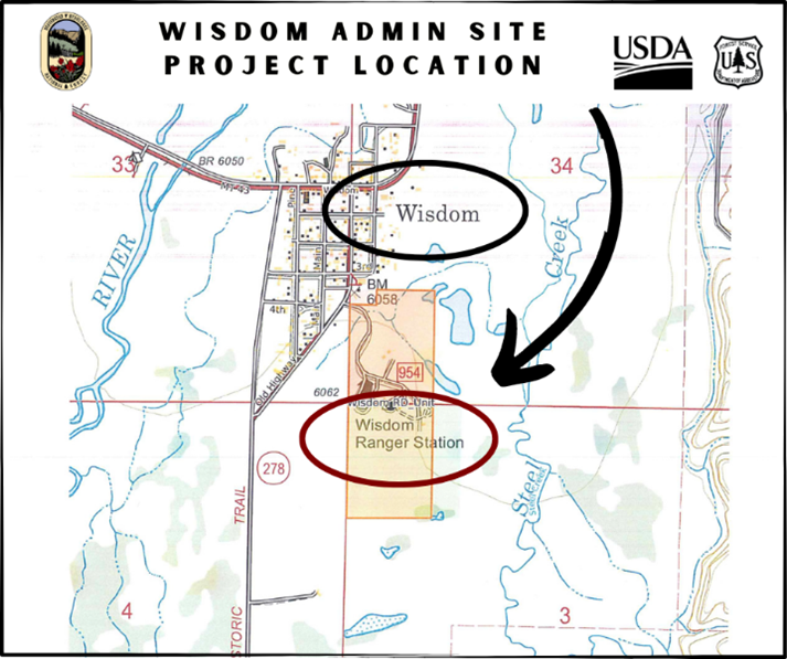
Wisdom RD Prescribed Fire Notification 05 13 2024
Related Incident: Beaverhead-Deerlodge NF Prescribed Fire Operations
Publication Type: Announcement
Firefighters and fuels specialists from the Beaverhead-Deerlodge National Forest are approaching the completion of their spring prescribed fire operations. Potential projects across the Forest may include the following locations, as weather and fuels conditions allow.
Wisdom Ranger District (Administrative Sites)
Firefighters and fuels crew members completed the Jackson Unit last week and plan to ignite the Steel Creek Unit and the Wisdom Unit today, May 13th. The two units total approximately 140 acres. The prescribed fire operations are designed to reduce fine fuel loading and to increase desirable forage for agency pack stock.
🔥 Wisdom Unit – at Wisdom Ranger District, along FS Rd 300.
🔥 Steel Creek Unit – up Steel Creek Rd (FS Rd 90), 5 miles east of Wisdom, MT.
Smoke impacts are expected to be low; smoke may be visible from Highway 43 and Highway 278 and from the greater Wisdom area. Fuels within the units should consume quickly, and smoke will be dispersed by transport winds.
For updates or more information, contact the Wisdom Ranger District at (406) 689-3243.
Horse Fire Daily Update, May 13, 2024 05 13 2024
Related Incident: Horse Fire AZTNF
Publication Type: News
Start Date: 05/05/2024 Location: Cave Creek Ranger District at MM 8 off Horseshoe Lake Road
Cause: Human-caused Acres: 512 Containment: 50%
Evacuations: Horseshoe Lake Campground
Structures: 0 Destroyed: 1 corral
Today’s Activity: This will be the final update from the Horse Fire under the management of the Central West Zone Incident Management Team. Tomorrow at 0800, the Central West Zone Incident Command Team will transfer command of the Horse Fire to a local Type 4 Team led by Incident Commander John Dimick. The Horse Fire is 50% contained; mop up and patrol phase will continue. Firefighters will continue to look for hot spots and/or undetected hotspots and smoke. They will address any safety concerns and continue to secure containment lines. Creeping and smoldering fire behavior within isolated interior pockets of fuel could produce visible smoke across the fire area for the near future.
Closure: The road closure is still in effect for the entire portion of NFSR 205, also known as Horseshoe Dam Road, starting from NFSR 19, also known as Bartlett Dam Road and motorized trails within the St. Clair OHV area through June 7, 2024, until 6 p.m., unless rescinded. For the safety of firefighters and the public, please avoid the area during fire suppression operations. Click to view the closure order and map.
Weather: Gusty winds and low relative humidity persist through the weekend
and into next week. Warm, fair weather with light terrain-based winds are expected through Tuesday.
Resources and Personnel Assigned: 64
Incident Information:
https://inciweb.wildfire.gov/incident-information/aztnf-horse-fire-aztnf
Twitter: https://twitter.com/TontoForest
Facebook: https://www.facebook.com/TontoNationalForest
Instagram: https://www.instagram.com/tontonationalforest/
Public Info: 602-428-5397
Media: 480-647-8082 & 530-260-6322
East Zone Roadside Underburn Update #2 05 12 2024
Related Incident:
Publication Type: Announcement
Fire resources completed 14.2 acres of prescribed fire operations yesterday, May 11, 2024. Ignitions will not continue today, May 12, 2024. Resources will remain on scene today and continue suppression operations. Further ignitions will be evaluated into this week.
Horse Fire Daily Update, May 12, 2024 05 12 2024
Related Incident: Horse Fire AZTNF
Publication Type: News
Start Date: 05/05/2024 Location: Cave Creek Ranger District at MM 8 off Horseshoe Lake Road
Cause: Human-caused Acres: 512 Containment: 50%
Evacuations: Horseshoe Lake Campground
Structures: 0 Destroyed: 1 corral
Today’s Activity: The majority of resources, including crews and engines, are demobilizing today. However, the remaining resources on the fire will continue patrolling and performing mop-up operations. Close monitoring of the fire will occur, while crews simultaneously engage in fire suppression repair activities. The primary objective of this repair work is to mitigate any adverse effects caused by the fire suppression efforts on the land, water, and natural resources.
Closure: The road closure is still in effect for the entire portion of NFSR 205, also known as Horseshoe Dam Road, starting from NFSR 19, also known as Bartlett Dam Road and motorized trails within the St. Clair OHV area through June 7, 2024, until 6 p.m., unless rescinded. For the safety of firefighters and the public, please avoid the area during fire suppression operations. Click to view the closure order and map.
Weather: Rain is not expected at the site of the fire. Sunday, typical diurnal (happening or active during the daytime) and valley winds will prevail with South Southwest wind speeds up to 10 – 15 mph and gusts up to 20 mph in the afternoon.
Resources and Personnel Assigned: 77
Incident Information:
https://inciweb.wildfire.gov/incident-information/aztnf-horse-fire-aztnf
Twitter: https://twitter.com/TontoForest
Facebook: https://www.facebook.com/TontoNationalForest
Instagram: https://www.instagram.com/tontonationalforest/
Public Info: 602-428-5397
Media: 480-647-8082 & 530-260-6322