
Boggy Draw Prescribed Fire Update 0592024 05 10 2024
Related Incident: 2025 San Juan National Forest Prescribed Fire Program
Publication Type: News
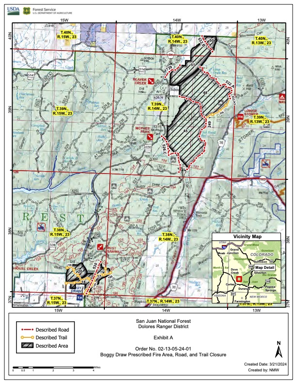
Firefighters on the Dolores Ranger District successfully completed prescribed burning across 1,133 acres on three burn units in the Boggy Draw area today (Thursday, May 9). Ignitions are complete for this week but crews will be on scene in the days to come to secure the burn and mitigate hazards near roads and trails.
The Boggy Draw Trail system is closed and will remain closed until it is safe to reopen. Personnel will work to make that closure as short as possible.
A planned burn of 700 acres on Hay Camp Mesa for tomorrow has been postponed due to expected unfavorable weather.
This burn was conducted to reduce the risk from future catastrophic wildfires on the forest and help protect nearby private property. A low-to-moderate-intensity burn reduces available fuels, thereby lowering the intensity of a possible future fire. Low-to- moderate intensity fire also improves conditions for native plants, animals, and their habitats and begins to restore ecological balance to areas where natural fires were previously suppressed.
Smoke has been heavy along short portions of the Dolores-Norwood road and could be overnight and into the morning hours on Friday. Fire personnel will continue to be working along this and other roads in the burn area so please drive with caution and use your headlights.
Clints Wellarea roads to temporarily close as Wolf Fire operations continue 05 09 2024
Related Incident:
Publication Type: News
Clints Well-area roads to temporarily close as Wolf Fire operations continue
State Route 87 to close Friday due to expected smoke impact
HAPPY JACK, Ariz., May 9, 2024 — Fire and road managers plan to temporarily close some area roads as ignitions continue on the Wolf Fire located about 3 miles northwest of Clints Well on the Coconino National Forest’s Mogollon Rim Ranger District.
The Wolf Fire Incident Management Team and the Arizona Department of Transportation (ADOT) will temporarily close a portion of state Route (SR) 87 beginning at 6 a.m. Friday, May 10, during firing operations.
SR 87 will close in both directions between the SR 260 junction at milepost 278.5 and the Lake Mary Road junction at milepost 290.5. Multiple detour options, including SR 260 and Interstate 17, will remain available.
Motorists are advised to check road status prior to traveling via ADOT’s road status website at az511.gov, the AZ511 app or by calling 511.
While fire managers plan to lift the road closure late Friday as soon as it is safe to do so, intermittent closures of SR 87 and other roads, such as Lake Mary Road, may occur throughout fire management should smoke impede roadway visibility.
Road closures are instituted in the interest of public and firefighter safety.
Forest visitors are advised to check forest road status via the Coconino National Forest’s website at coconinonationalforest.us prior to traveling on forest roads.
Speed limits in the Wolf Fire area have been temporarily reduced to allow for firefighter and public safety. Motorists are asked to abide by all posted signage and remain cognizant of fire personnel working in the area.
A closure order remains in place for the area surrounding the fire, as does a temporary flight restriction. Drone operators are asked to abide by the issued restrictions.
The Northern Arizona Type 3 Incident Management Team assumed management of the Wolf Fire on Monday, May 6.
There are roughly 150 personnel assigned to the Wolf Fire, including two Hotshot crews, nine engines, one dozer and one hand crew.
The Wolf Fire is currently 1,616 acres, and fire managers plan to treat roughly 11,000 total acres of forest land over the coming weeks during the fire management process.
Lightning-caused fires allow an opportunity for land treatment: The removal of forest fuels – such as pine needle accumulation, dead and down trees and other dry plant matter – that create hazardous conditions that could lead to potential catastrophic wildfire.
Naturally-ignited fires work similarly to prescribed fires in that they allow fire managers to help fire fulfill its natural role in the northern Arizona ecosystem.
Land treatment using fire is an important part of the Forest Service’s 10-year Wildfire Crisis Strategy, which aims to reduce the risk of wildfire to critical infrastructure and communities.
As part of the overall Wildfire Crisis Strategy, the Coconino National Forest is committed to restoring land and protecting watersheds – including work on the Cragin Watershed Protection Project – as part of the wider Four Forest Restoration Initiative (4FRI).
Throughout the fire management process, fire managers will employ a strategic, risk-based response that is appropriate for changing conditions on the ground. This response will use a full range of management actions that consider fire and fuel conditions, weather, values at risk and resource availability.
Smoke is an unavoidable byproduct of land restoration work and wildfire. While early spring wind patterns typically funnel smoke upward for a wider distribution that will lessen smoke impact to nearby communities, area residents and visitors should be prepared for lingering smoke in the Wolf Fire area. More information is available at airnow.gov.
Horse Fire Daily Update, May 9, 2024 05 09 2024
Related Incident: Horse Fire AZTNF
Publication Type: News
Start Date: 05/05/2024 Location: Cave Creek Ranger District at MM 8 off Horseshoe Lake Road
Cause: Human-caused Acres: 525. Containment: 29%.
Evacuations: Horseshoe Lake Campground
Structures: Destroyed: 1 (corrals)
Today’s Activity: The fire is divided into 2 divisions, Alpha on the west side and Zulu on the east. Alpha will continue to eliminate any smoke and secure the 205 road to the Verde River. Zulu will insure the east side of the river is 100% contained and holding, and continue strengthening all lines.
Closure: There is a road closure in effect for the entire portion of NFSR 205, also known as Horseshoe Dam Road, starting from NFSR 19, also known as Bartlett Dam Road and motorized trails within the St. Clair OHV Area beginning 10 a.m. Wednesday, May 8, through June 7, 2024, until 6 p.m., unless rescinded. For the safety of firefighters and the public, please avoid the area during fire suppression operations. Click to view the closure order and map.
Weather: Seasonally dry conditions with some degree of gusty afternoon winds will be common at the fire site for the next couple of days. Minimum relative humidity levels near 10% and only fair overnight recoveries should be common.
Resources and Personnel Assigned: 146
Incident Information:
https://inciweb.wildfire.gov/incident-information/aza5s-stockton-hill
Twitter: https://twitter.com/TontoForest
Facebook: https://www.facebook.com/TontoNationalForest
Instagram: https://www.instagram.com/tontonationalforest/
Public Info: 602-428-5397
Media: 480-647-8082 & 530-260-6322
![]()
Little Yamsay Fire Update May 9, 2024 05 09 2024
Related Incident: Little Yamsay Fire
Publication Type: News
Little Yamsay Fire Update- May 9, 2024
Fire Information: 971-978-7899
Email: 2024.littleyamsay@firenet.gov
Size: 2,200 acres Location: 15 miles southeast of Chemult, OR near Klamath Marsh
Start Date: Detected April 20, 2024 Cause: Lightning Total Personnel: 108
Crews: 3 Engines: 5 Heavy Equipment: 4 Water Tenders: 2
After five days of cooler weather, warmer temperatures and drier fuels allowed firefighters to resume firing operations in phase two and phase three during Wednesday’s operational shift. Hotshots utilized drip torches to establish fire along Forest Rd. 4975, effectively creating a buffer along the southeast edge of the fire perimeter while other crews continued with road preparation to the west.
Thursday, firefighters will work to complete phase two and continue firing in phase three. This will be accomplished with use of Unmanned Aerial Systems (UAS) to drop plastic sphere incendiary devices that ignite within the fire perimeter. The utilization of UAS allows for safer and more efficient firing operations within the interior.
The goal is to promote low-intensity fire activity to reduce fuel loading, mimicking a regime of natural fire that promotes forest health and enhances the biodiversity within the forest ecosystem. With the reduction of “ladder fuels” that can allow fire to travel into the canopy, the Little Yamsay fire footprint will break up the continuity of fuels to provide a substantial buffer that will protect against a catastrophic wildfire during the heat of the summer, and give firefighters an area to stop a wildfire that could become large and destructive.
So far, the type three incident management team has completed 2,200 acres of treatment in a three-phase sequence, and over the next few days looks to complete an additional 3,500 acres. Combined with the footprint from the 2023 Dillon Creek Fire, the area will have 10,000 acres of forest containing reduced ladder fuels, less surface fuels, widely spaced legacy pines, and enhanced biodiversity.
There are no closures or evacuations for the Little Yamsay Fire. Residents and visitors traveling to the area are encouraged to drive responsibly as emergency firefighter vehicles will be present. Expect delays as traffic control may be implemented due to smoke and/or hazards.
Facebook: https://www.facebook.com/SCOFMPFIREINFO
Inciweb: https://inciweb.wildfire.gov/incident-information/orfwf-little-yamsay-fire
YouTube: http://www.youtube.com/@scofmpfireinformation6729
Fremont-Winema NF Facebook: https://www.facebook.com/R6FWNF
BLM Prescribed fire planned on May 9, 2024 at West Dolores Rim 05 08 2024
Related Incident:
Publication Type: Announcement
The Bureau of Land Management (BLM) plans to conduct prescribed fire treatments on Thursday, May 9, 2024, at West Dolores Rim project area located approximately seven miles east, northeast of Dove Creek, CO. If conditions allow firefighters plan to burn in two different parts of the project area within the Dolores River Recreation Area managed by the Tres Rios field office in Dolores County. Units 2 and 3 will be burned to treat the Ponderosa pine understory of mountain brush leaf litter and needle cast. These two units are located directly east of Dove Creek, CO. Units 17B and 18B treatments will burn remaining debris from mastication treatments and are located northeast of Dove Creek, CO. Firefighters plan to use hand ignitions and Unmanned Aircraft System (UAS) to reintroduce low intensity fire to a fire-adapted ecosystem in a controlled manner to protect Ponderosa pine stands, enhance wildlife habitat, restore healthy forests and species diversity, and maintain a fire-resilient landscape.
Prescribed fire mimics natural processes under appropriate weather and vegetative conditions, which improves forage for wildlife, increases plant diversity by creating breaks in the understory where native grasses and forbs can thrive, and effectively reduces hazardous vegetation while enhancing woodland health.
The projects are part of the BLM’s ongoing commitment to protect human health and safety while maintaining or enhancing forest and woodland health and functionality. The BLM obtained smoke permits from the Colorado State Air Pollution Control Division, which identify atmospheric conditions under which the burns can be implemented. Prescribed fire smoke may affect your health. For more information, visit https://www.colorado.gov/pacific/cdphe/wood-smoke-and-health.
More information on Southwest District prescribed fuel treatments https://inciweb.wildfire.gov/incident-information/cosjd-southwest-district-blm-prescribed-fire and follow our Facebook page https://www.facebook.com/BLMMontroseFireUnit or Twitter https://twitter.com/SWD_Fire
Horseshoe Dam Road (NFSR 205) Emergency Closure For Public Safety 05 08 2024
Related Incident: Horse Fire AZTNF
Publication Type: Closures
Order No. 03-12-01-24-15
U.S. Department of Agriculture, U.S. Forest Service Tonto National Forest
Cave Creek Ranger District
Horse Fire Public Safety NFS Road and Motorized Trails Emergency Closure
PROHIBITIONS
Pursuant to 16 U.S.C. § 551 and 36 C.F.R. § 261.50 (b), the following is prohibited on the National Forest System (NFS) road and trails in the Cave Creek Ranger District, Tonto National Forest, described below and shown on the attached map incorporated into this Order as Exhibit A (the Described Roads and Trails):
1. Using any motor vehicle on the Described Road. 36 C.F.R. § 261.54(a) 2. Being on the Described Road. 36 C.F.R. § 261.54(e)
3. Being on the Described Trail. 36 C.F.R. § 261.55(a)
4. Using any motor vehicle on the Described Trail. 36 C.F.R. § 261.55(b)
EXEMPTIONS
Pursuant to 36 C.F.R. § 261.50(e), the following persons are exempt from this Order:
- PersonswithForestServicePermitNo.FS-7700-48(PermitforUseofRoads, Trails, or Areas Restricted by Regulation or Order), specifically exempting them from this Order or a written determination by a Forest Service authorized officer that a permit is not required under 36 C.F.R. § 251.50(e)(1) or (2).
- Any Federal, State, or Local Officer, or member of an organized rescue or firefighting resource in the performance of an official duty.
DESCRIBED ROAD AND TRAILS
The entire portion of National Forest System (NFS) Road 205, also known as Horseshoe Dam Road, starting from the junction of NFS Road 19, also known as Bartlett Dam Road, within Township 6 North, Range 6 East, Section 9, then following north until its terminus at Horseshoe Lake within Township 7 North, Range 6 East, Section 2.
The following Motorized Trails (MT) within the St. Clair OHV Area are closed:
MT-1104, starting from intersection with NFS Road 205, then following east to its terminus at the intersection of MT-532.
MT-1117, starting from the intersection with NFS Road 19, then following north then west to its terminus at the intersection with MT-532.
MT-532, starting at the intersection with NFS Road 19, then traveling northeast until the intersection with MT-42, then following northeast from the intersection with MT-42 until its terminus at the Verde River.
MT-1069, starting at the intersection with MT-532, then following southeast then east to its intersection with MT-42, then traveling east from the intersection with MT-42 east until its terminus at the Verde River.
MT-42, starting at then intersection with NFS Road 459 (also referred to as North Lake Road), then following northwest to the intersection with MT-1069, then following northwest from the intersection with MT-1069, to the intersection with MT-532, then following northwest then west from the intersection with MT- 532 to its terminus at the intersection with NFS Road 205.
PURPOSE
To provide public health and safety due to firefighting operations and fire danger associated with the uncontrolled Horse Fire on the Tonto National Forest.
IMPLEMENTATION
This Order shall be in effect from May , 2024, at :00 m through June 07, 2024, at 6:00pm, unless rescinded.
A map identifying the Described Road and Trails is attached and made part of this Order as Exhibit A. For a digital version of this Order and Exhibit A, go to https://www.fs.usda.gov/alerts/tonto/alerts-notices
Unless otherwise expressly defined in this Order, the terms used in this Order are defined by the regulations of the Secretary of Agriculture, 36 C.F.R. Chapter II,
Parts 200-299. If there are terms in this Order that are not expressly defined in the Order or 36 C.F.R. Chapter II, Parts 200-299, their meaning shall be determined by their plain language definitions.
- AviolationoftheaboveprohibitionsispunishableasaClassBmisdemeanorby a fine of not more than $5,000 for individuals and $10,000 for organizations, or by imprisonment for not more than six months, or both. 16 U.S.C. § 551; 18 U.S.C. §§ 3559, 3571, and 3581.
- Contact the Cave Ranger District in Scottsdale, AZ, (480) 595-3300, and Tonto National Forest Supervisors Office in Phoenix, AZ, (602) 225-5200, for more information about this Order.
- This Order supersedes any previous Orders prohibiting the same or similar acts on the same Described Road and Trails.
Horse Fire Daily Update, May 8, 2024 05 08 2024
Related Incident: Horse Fire AZTNF
Publication Type: News
Today’s Date: 05/08/2024
Start Date: 05/04/2023 Location: Cave Creek Ranger District at MM 8 off Horseshoe Lake Road
Cause: Human-caused Acres: 525. Containment: 29%.
Evacuations: Horseshoe Lake Campground
Structures Damaged: 1 Destroyed: 1
Today’s Activity: Fire crews have been actively conducting fire suppression operations with two crews on the east side of the fire securing a line and crews securing fire lines north of KA Ranch.
Closure: A new closure order has been put into effect for the entire portion of NFSR 205, also known as Horseshoe Dam Road, starting from NFSR 19, also known as Bartlett Dam Road and motorized trails within the St. Clair OHV Area beginning 10 a.m. Wednesday, May 8, through June 7, 2024, until 6 p.m., unless rescinded. For the safety of firefighters and the public, please avoid the area during fire suppression operations. Click to view the closure order and map.
Weather: Seasonally dry conditions with some degree of gusty afternoon winds will be common at the fire site for the next couple of days. Minimum relative humidity levels near 10% and only fair overnight recoveries should be common.
Resources and Personnel Assigned: 146
Type 1 Hand Crews: 3, Type 2 Hand Crews: 2, Type 3 Helicopters: 2, Engines: 6
Water Tenders: 2 Ambulance: 1
Incident Information: https://inciweb.wildfire.gov/incident-information/aza5s-stockton-hill
Twitter: https://twitter.com/TontoForest
Facebook: https://www.facebook.com/TontoNationalForest
Instagram: https://www.instagram.com/tontonationalforest/
Public Info: 602-428-5397
Media: 480-647-8082 & 530-260-6322
Horse Fire Daily Update, May 8, 2024 05 08 2024
Related Incident: Horse Fire
Publication Type: News
Today’s Date: 05/08/2024
Start Date: 05/04/2023 Location: Cave Creek Ranger District at MM 8 off Horseshoe Lake Road
Cause: Human-caused Acres: 525. Containment: 29%.
Evacuations: Horseshoe Lake Campground
Structures Damaged: 1 Destroyed: 1
Today’s Activity: Fire crews have been actively conducting fire suppression operations with two crews on the east side of the fire securing a line and crews securing fire lines north of KA Ranch.
Closure: A new closure order has been put into effect for the entire portion of NFSR 205, also known as Horseshoe Dam Road, starting from NFSR 19, also known as Bartlett Dam Road and motorized trails within the St. Clair OHV Area beginning 10 a.m. Wednesday, May 8, through June 7, 2024, until 6 p.m., unless rescinded. For the safety of firefighters and the public, please avoid the area during fire suppression operations. Click to view the closure order and map.
Weather: Seasonally dry conditions with some degree of gusty afternoon winds will be common at the fire site for the next couple of days. Minimum relative humidity levels near 10% and only fair overnight recoveries should be common.
Resources and Personnel Assigned: 146
Type 1 Hand Crews: 3, Type 2 Hand Crews: 2, Type 3 Helicopters: 2, Engines: 6
Water Tenders: 2 Ambulance: 1
Incident Information: https://inciweb.wildfire.gov/incident-information/aza5s-stockton-hill
Twitter: https://twitter.com/TontoForest
Facebook: https://www.facebook.com/TontoNationalForest
Instagram: https://www.instagram.com/tontonationalforest/
Public Info: 602-428-5397
Media: 480-647-8082 & 530-260-6322
Little Yamsay Fire Update May 8, 2024 05 08 2024
Related Incident: Little Yamsay Fire
Publication Type: News
Little Yamsay Fire Update - May 8, 2024
Fire Information: 971-978-7899
Email: 2024.littleyamsay@firenet.gov
Size: 2,009 acres Location: 15 miles southeast of Chemult, OR near Klamath Marsh
Start Date: Detected April 20, 2024 Cause: Lightning Total Personnel: 91
Crews: 2 Engines: 5 Heavy Equipment: 6 Water Tenders: 4
Firefighters continue preparing control lines for firing operations that will resume when weather and fuel moistures are favorable. Once fuels are receptive, Union, La Grande, and Lakeview Interagency Hotshot Crews will be using drip torches to ignite fuels along with aerial ignition support from Unmanned Aircraft Systems (UAS or drones) modules. Test fires will likely occur this afternoon in phases two and three to evaluate whether or not objectives are being met.
The weather forecast calls for a warming and drying trend as a high pressure system strengthens over the region. This warm up will push temperatures well above averages with daytime humidities dropping into the teens. This weekend will see highs reach the mid-70s with low RH. Wind direction will be northeast, becoming east by Friday.
This lightning-caused wildfire is an opportunity to influence the spread of low-intensity fire into an area that was already thinned, logged, and prepared for prescribed fire. Our group of experienced, professional wildland firefighters are carefully and methodically conducting a series of firing operations that will mimic historical natural fire, burning the fuels between the main fire and our established containment lines. This operations falls under the guidance and directive of the Wildfire Crisis Strategy. Below is an excerpt from this document.
“It will take a paradigm shift in land management across jurisdictional boundaries to reduce risk and restore fire-adapted landscapes….To restore forest health and reduce wildfire risk, a large multi-organizational workforce with expertise in proactive fuels and forest health management is needed for thinning forests, conducting prescribed fires, and using lightning fires and other unplanned ignitions to return fire to the land and restore forest health…We need to thin western forests and return low-intensity fire to western landscapes in the form of both prescribed and natural fire, working to ensure that forest lands and communities are resilient in the face of the wildland fire that fire-adapted landscapes need.”
There are no closures or evacuations for the Little Yamsay Fire. Residents and visitors traveling to the area are encouraged to drive responsibly as emergency firefighter vehicles will be present. Expect delays as traffic control may be implemented due to smoke and/or hazards.
Social Media Links:
Facebook: https://www.facebook.com/SCOFMPFIREINFO
Inciweb: https://inciweb.wildfire.gov/incident-information/orfwf-little-yamsay-fire
YouTube: http://www.youtube.com/@scofmpfireinformation6729
Fremont-Winema NF Facebook: https://www.facebook.com/R6FWNF
Coconino National Forest starting management of lightningcaused Wolf Fire near Clints Well 05 02 2024
Related Incident:
Publication Type: News
Coconino National Forest starting management of lightning-caused Wolf Fire near Clints Well
Lightning-sparked wildfire located in area slated for a prescribed fire project later this year
FLAGSTAFF, Ariz., May 2, 2024 — The Coconino National Forest’s Mogollon Rim Ranger District will begin managing a lightning-caused wildfire sparked earlier this week in an area already slated for a prescribed fire within the coming weeks.
The Wolf Fire, reported the morning of April 29, is roughly 1 acre and located about 3 miles northwest of Clints Well.
Fire managers had planned to treat the area of the Wolf Fire with the Clints prescribed fire project scheduled for later this month and will be proceeding with land treatment plans following the lightning-sparked ignition.
“These opportunities give us the chance to help fire as it plays its natural role in our fire-adapted ecosystem,” said acting District Ranger True Brown. “We’d already planned to treat this piece of land using prescribed fire. Now, we’re just going to treat it with wildfire. We think this will be a great thing for our nearby communities.”
Lightning-caused wildfires allow an opportunity for land treatment: The removal of forest fuels – such as pine needle accumulation, dead and down trees and other dry plant matter – that create hazardous conditions that could lead to potential catastrophic wildfire.
While differing from a prescribed fire because they are unplanned, naturally-ignited wildfires use many of the same methods to allow fire managers to help fire fulfill its natural role in the northern Arizona ecosystem.
Fire managers aspire to treat roughly 11,000 acres of land over the course of the next two weeks. The northern Arizona-based Type 3 team has been ordered in to assume management of the Wolf Fire beginning Monday, May 6.
Throughout the fire management process, the team will employ a strategic, risk-based response that is appropriate for changing conditions on the ground. This response will use a full range of management actions that consider fire and fuel conditions, weather, values at risk and resource availability.
Ignitions will begin Monday, May 6. Fire managers hope to continue ignitions for roughly two weeks.
Land treatment using fire – whether it’s conducted as part of a planned prescribed fire or part of an unplanned wildfire – is an important part of the Forest Service’s 10-year Wildfire Crisis Strategy, which aims to reduce the risk of wildfire to critical infrastructure and communities.
As part of the overall Wildfire Crisis Strategy, the Coconino National Forest is committed to restoring land and protecting watersheds – including work on the Cragin Watershed Protection Project – as part of the wider Four Forest Restoration Initiative (4FRI).
Smoke is an unavoidable byproduct of land restoration work and wildfire. While early spring wind patterns typically funnel smoke upward for a wider distribution that will lessen smoke impact to nearby communities, area residents and visitors should be prepared for lingering smoke in the Wolf Fire area. More information is available at airnow.gov.
A closure order for the area of the Wolf Fire is expected to be issued soon.