
Greenbrier Ranger Station Brush Pile Burn 04 24 2024
Related Incident:
Publication Type: Announcement
Fire staff plan to burn a brush pile at the Greenbrier Ranger Station in Bartow on Thursday, April 25, weather permitting. Ignition will begin at approximately 11 a.m. but could begin earlier if conditions are favorable. Smoke will be visible.
Signs will be posted on roads near the pile burn before and during operations. Residents and Forest visitors may see and smell smoke. If you encounter smoke on the highway, slow down, turn on your vehicle’s lights and drive appropriately for the conditions.
The local radio station has been alerted. Updates will be posted on InciWeb and our Facebook page (https://www.facebook.com/MonongahelaNF).
Forsythe II AM Update 04 24 2024
Related Incident: Forsythe II Prescribed Burn
Publication Type: Announcement
Firefighters have conducted a test fire and verified that conditions are good for prescribed fire ignitions to continue as planned today, Wednesday, April 24, for the Forsythe II Prescribed burn area. Smoke may be notably visible in the Gross Reservoir area as well as along the Front Range.
Fire managers work closely with experts to minimize the impacts of smoke. Air quality is carefully monitored before and during a prescribed fire and all prescribed burns comply with state air quality regulations to minimize impacts to communities. To learn more about the potential health impacts of smoke visit www.colorado.gov/pacific/cdphe/wood-smoke-and-health.
Additional email notifications will be sent out periodically during ignition periods. To receive updates, make sure to join our email list and select "Forest Health & Fire: North of Hwy 72 (Coal Creek Canyon) to Hwy 119 Boulder Canyon (Nederland and Magnolia areas)". Additional information, including maps and project details for the Forsythe II prescribed burn plan, can be found here on InciWeb.
Have questions? Email ARPFireInfo@usda.gov.
Forsythe II Update 04 23 2024
Related Incident: Forsythe II Prescribed Burn
Publication Type: Announcement
Fire managers are monitoring conditions for potential ignition tomorrow, Wednesday April 24, on the Forsythe II Prescribed Burn. Ignitions will be contingent on appropriate weather conditions falling within the parameters of the burn plan.
Due to the nature of the fuel content within this prescribed burn area, there may be notable smoke visible from the Forsythe II Prescribed Burn during this ignition period. We have uploaded a video to the "videos" tab on this website with additional information.
Residents and visitors in the area should expect to see smoke and flames when operations are underway. The following areas in particular may see and smell smoke during this burn: Lakeshore subdivision, Crescent Village, Crescent Meadows, Gross Reservoir, Walker Park Ranch, Miramonte, Wondervu, Eldorado Canyon State Park, and parts of eastern Boulder County. Fire managers work closely with experts to minimize the impacts of smoke to the best extent possible. Air quality is carefully monitored before and during a prescribed fire and all prescribed burns comply with state air quality regulations to minimize impacts to communities. More information is available at https://www.colorado.gov/pacific/cdphe/wood-smoke-and-health.
The public is advised to not call 911 regarding this prescribed fire activity. Additional email notifications will be sent on days when burning is expected to begin. To receive these ignition updates, join our email list and select "Forest Health & Fire: North of Hwy 72 (Coal Creek Canyon) to Hwy 119 Boulder Canyon (Nederland and Magnolia areas)." These updates will also be posted on InciWeb.
Have questions? Email ARPFireInfo@usda.gov.
Firing Operations Complete on Unit F3 Prescribed Burn 04 23 2024
Related Incident: Baldy Mountain Landscape Resiliency and Habitat Improvement Project Prescribed Burn
Publication Type: Announcement
Firing operations are complete for today's prescribed fire on the Baldy Mountain Project's Unit F3. Personnel will remain on scene until the area is deemed secure and patrol will be ongoing until the fire is declared out. Residual smoke may be seen through the end of the week from the communities of Montrose, Ridgway, Ouray, Log Hill, and other dispersed areas along the Highway 550 corridor.
April 24, 2024 Prescribed Fire Update 04 24 2024
Related Incident:
Publication Type: Announcement
The Lolo National Forest will continue to conduct prescribed fire operations in several locations across the Forest today, as weather and fuels conditions allow.
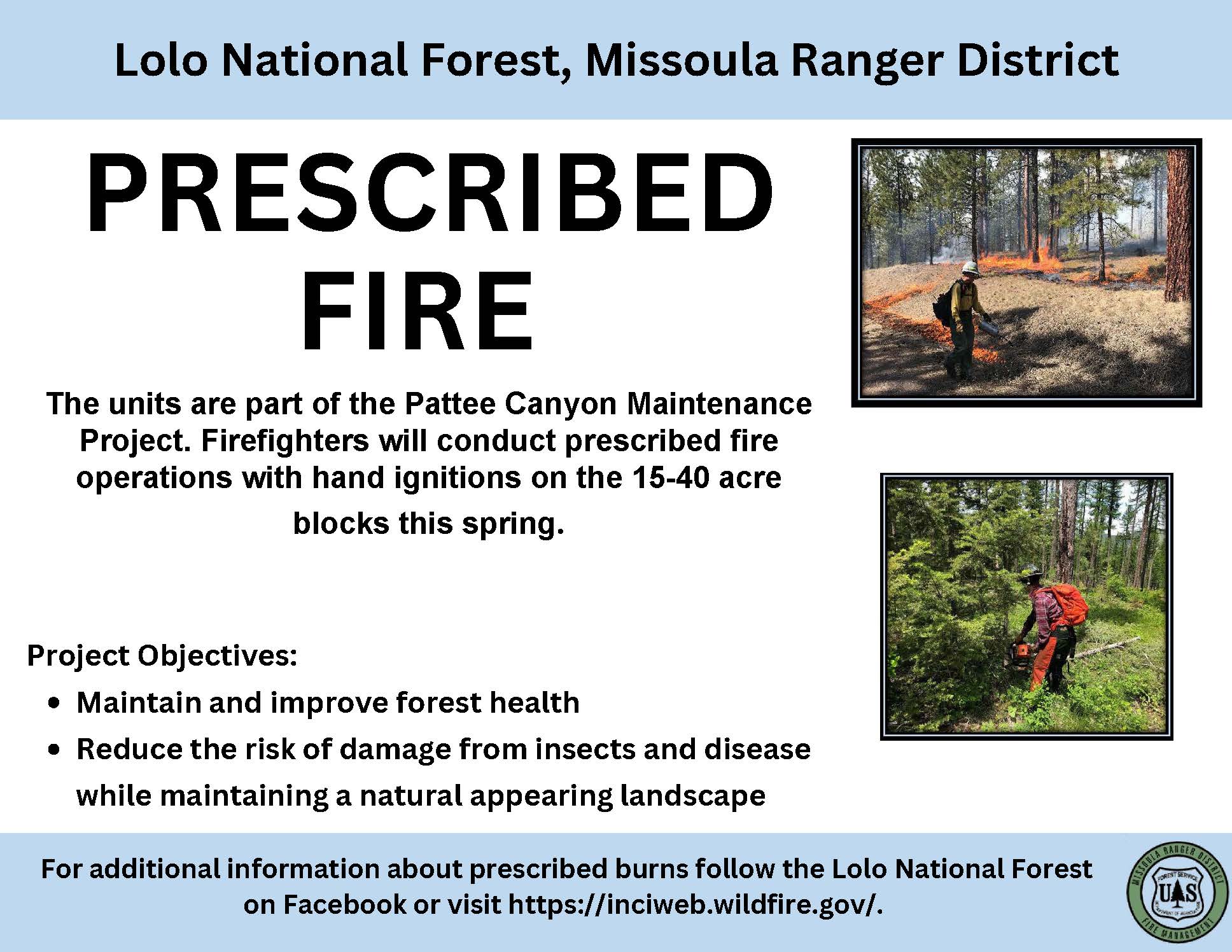
Missoula Ranger District: The 19-acre prescribed fire will take place in the area in Pattee Canyon, 15 miles southeast of Missoula. This unit is part of the Pattee Canyon maintenance project. The objective of this project is to maintain and improve forest health, reduce the risk of damage from insects and disease while maintaining a natural appearing landscape. Smoke may be visible from the Missoula, Bonner, and parts of the I-90 corridor.
Ninemile Ranger District: The 375-acre Frenchtown Face unit is located approximately 9 miles north of Ninemile Road near the Stoney Creek drainage. Firefighters plan to use aerial ignitions in this project area. The Smoke will likely be visible from Alberton, Ninemile, Huson and Frenchtown.
Plains/Thompson Falls Ranger District: Firefighters plan to conduct up to 80 acres of understory burning on two different units in the Clear Creek units 6 miles west of Thompson Falls. Smoke may be visible from Thompson Falls, Plains, and surrounding communities.
Firefighters and engines will implement the prescribed burn, patrol, and monitor the burning over the next few days.
Baldy Mountain Prescribed Fire Test Fire Successful 04 23 2024
Related Incident: Baldy Mountain Landscape Resiliency and Habitat Improvement Project Prescribed Burn
Publication Type: Announcement
This morning, fire resources from U.S. Forest Service-Grand Mesa, Uncompahgre & Gunnison National Forests and BLM - Southwest Colorado Fire and Aviation Management Unit successfully completed a test burn on Unit F3 and will proceed with the 112-acre prescribed burn plan. We’ll update this page and {inciweb} when operations are completed for the day.
April 23, 2024 Prescribed Fire Update 04 22 2024
Related Incident:
Publication Type: Announcement
Pending conditions, firefighters on the Lolo National Forest will conduct prescribed fire operations on several districts.
Ninemile Ranger District:
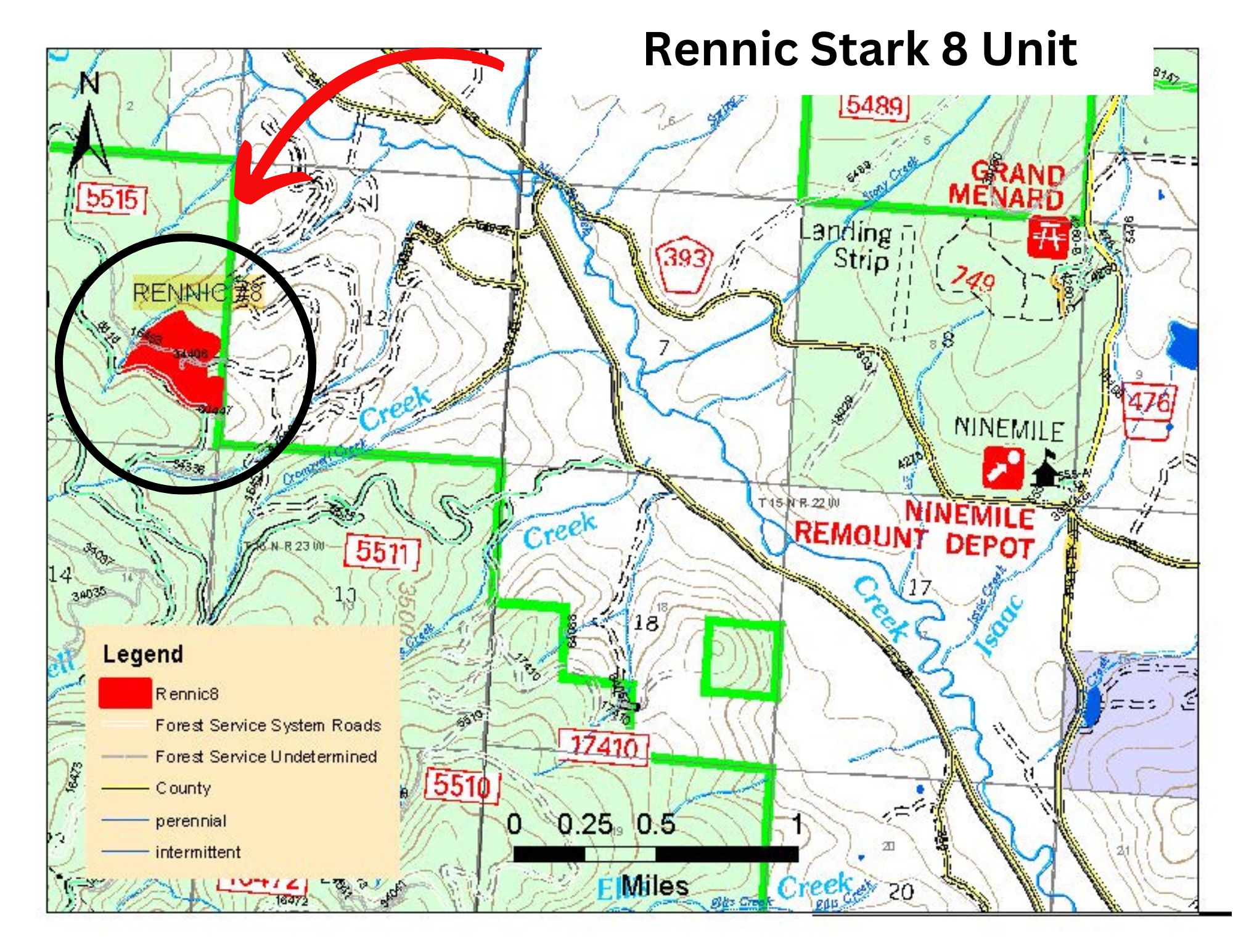
The 40-acre Rennic Stark unit is near Rennic Creek approximately 3 miles west of Ninemile Ranger District Office. Smoke may be visible from Alberton, Ninemile, Huson and Frenchtown for the duration of the burn. Engines and firefighters will be utilizing Forest Service Road 5515, please use caution and slow down.
Plains/Thompson Falls Ranger District:
Firefighters plan to conduct up to 50 acres of understory burning on the Clear Creek units 6 miles west of Thompson Falls. The district also plans to conduct up to 20 acres of pile burning on the Tree Farm unit located 2 miles northwest of Plains. Minimal smoke impacts are anticipated; however, smoke may be visible from may be visible from Thompson Falls, Plains, and surrounding communities.
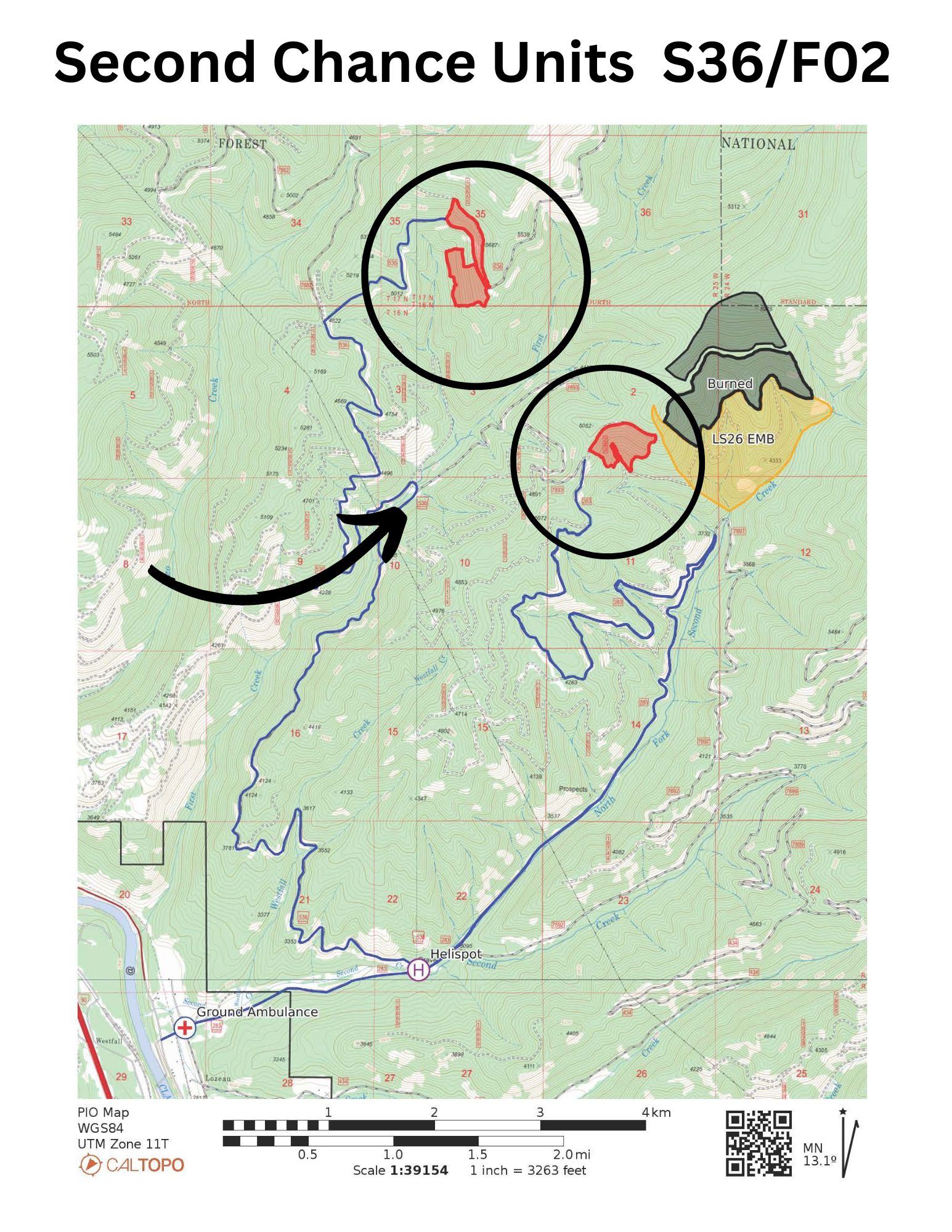
Superior Ranger District: Firefighters will conduct up 180 acres of prescribed burning 8 miles east of Superior in the First Creek and North Fork Second Creek drainages. This prescribed burn will utilize aerial ignitions to reduce fuel from previous management operations. Residents may see helicopter Smoke may be visible through the Interstate 90 corridor near Superior. Smoke should disperse following ignition but may settle along drainages and in lower elevations in the overnight hours.
All prescribed fires are implemented in compliance with Montana air quality standards and coordinated with the Montana Department of Environmental Quality to minimize the impacts of smoke. For the latest air quality information visit www.airnow.gov.
Prescribed fire is one of the most effective management tools used by the Forest Service. Prescribed fire allows fire managers to mimic the natural role of fire on the landscape helping to remove hazardous fuels, create a fire-adapted ecosystem, and restore wildlife habitat.
April 22 Scott Bar Mountain Prescribed Burn POSTPONED 04 22 2024
Related Incident:
Publication Type: Announcement
Due to an unfavorable weather forecast today's planned prescribed burn at Scott Bar Mountain has been postponed. Fire managers will monitor future forecasts and fuels conditions for another window of opportunity.
April 22, 2024 Prescribed Fire Update 04 22 2024
Related Incident:
Publication Type: Announcement
Pending favorable conditions, firefighters on the Superior Ranger District are planning to conduct prescribed fire operations today to reduce hazardous fuels from previous vegetation management operations and create a fire adapted ecosystem.
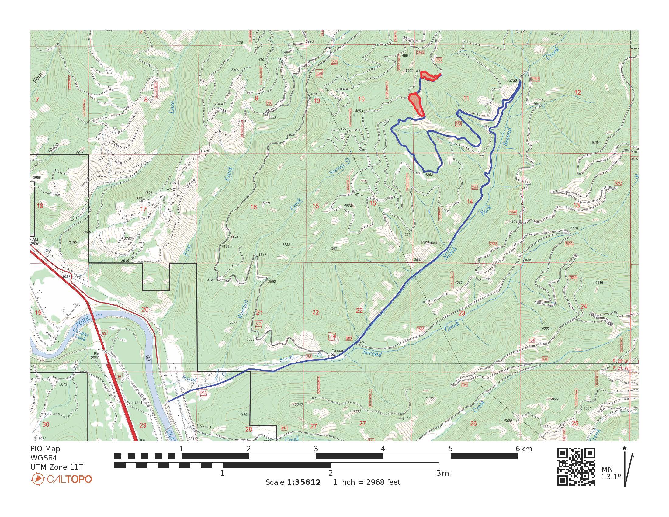
Superior Ranger District: Firefighters will conduct up to 13 acres of prescribed fire operations 8 miles east of Superior in the Second Creek area. Smoke may be visible through the Interstate 90 corridor near Superior.
Prescribed fire will be implemented in compliance with Montana air quality standards and coordinated with the Montana Department of Environmental Quality and the appropriate county health departments to minimize the impacts of smoke.
Firefighters will implement the prescribed burns, patrol, and monitor the burning over the next few days.
Prescribed burning to begin at Scott Bar Mountain 04 21 2024
Related Incident:
Publication Type: Announcement
Conditions are looking favorable for #KlamathNF fire personnel to begin prescribed burning out at Scott Bar Mountain tomorrow (Monday).
Scott Bar Mountain is about 12 miles west of Fort Jones near Jones Beach and Indian Scotty Campground on the Salmon/Scott River Ranger District. Goals for the burn include improving defensibility of communities during wildfires, increasing fire resiliency of timber stands, and improving habitat for wildlife.
The Scott Bar Mountain Prescribed Burn is an ongoing effort to maintain a shaded fuel break that is strategically connected to a series of ridgetop fuel reduction treatments from several other projects. The connectivity of these projects creates a landscape-scale fuel break that can be used during wildfire events to protect communities, infrastructure, and natural resources.
Prescribed burning and Scott Bar Mountain could occur for several days on up to 550 acres. Burning will be taking place directly along the Scott River Road at times. Motorists are asked to watch for smoke, fire personnel, and equipment. Please reduce speeds when travelling through the area. There could be periods where traffic will be controlled with a pilot car is conditions warrant.