
Ignitions begin on lightningcaused Wolf Fire on Mogollon Rim Ranger District; area surrounding fire closed to public 05 07 2024
Related Incident:
Publication Type: News
Ignitions begin on lightning-caused Wolf Fire on Mogollon Rim Ranger District; area surrounding fire closed to public
HAPPY JACK, Ariz., May 7, 2024 — Ignitions have started on the Wolf Fire, a lightning-sparked wildfire located about 3 miles northwest of Clints Well on the Coconino National Forest’s Mogollon Rim Ranger District.
A closure order has been issued for the area surrounding the wildfire.
Fire managers had already planned to treat the area of the Wolf Fire with the Clints prescribed fire project scheduled for later this month.
Despite the change in cause of ignition – from a planned prescribed fire to an unplanned naturally-sparked wildfire – fire managers will proceed with ignitions as part of an overall fire management plan to improve the health of the forest landscape.
Fire managers are looking to treat about 2,000 acres of land over the next few days and are hoping to treat 11,000 acres over the course of the next roughly two weeks.
The northern Arizona-based Type 3 Incident Management Team assumed management of the 6-acre Wolf Fire on Monday, May 6.
“We’re looking forward to using the Wolf Fire to accomplish several objectives for this piece of land,” said Deputy Incident Commander Jesse Causer. “The management techniques we’re implementing here allow us to reduce hazardous fuel loading, protect the nearby C.C. Cragin Watershed and fulfill our obligations to the Forest Service’s Wildfire Crisis Strategy.”
Heavy smoke impacts along Lake Mary Road are expected over the coming days. Speed limits in the Wolf Fire area – from mile post 300 to the junction of Highway 87 – will be temporarily reduced to allow for firefighter and public safety.
Motorists are asked to remain cognizant of fire personnel working in the area.
A temporary flight restriction has been issued for the area surrounding the Wolf Fire. Drone operators are asked to abide by the issued restrictions.
Lightning-caused wildfires allow an opportunity for land treatment: The removal of forest fuels – such as pine needle accumulation, dead and down trees and other dry plant matter – that create hazardous conditions that could lead to potential catastrophic wildfire.
Naturally-ignited wildfires work similarly to prescribed fires in that they allow fire managers to help fire fulfill its natural role in the northern Arizona ecosystem.
Land treatment using fire – whether it’s conducted as part of a planned prescribed fire or part of an unplanned wildfire – is an important part of the Forest Service’s 10-year Wildfire Crisis Strategy, which aims to reduce the risk of wildfire to critical infrastructure and communities.
As part of the overall Wildfire Crisis Strategy, the Coconino National Forest is committed to restoring land and protecting watersheds – including work on the Cragin Watershed Protection Project – as part of the wider Four Forest Restoration Initiative (4FRI).
Throughout the fire management process, fire managers will employ a strategic, risk-based response that is appropriate for changing conditions on the ground. This response will use a full range of management actions that consider fire and fuel conditions, weather, values at risk and resource availability.
Smoke is an unavoidable byproduct of land restoration work and wildfire. While early spring wind patterns typically funnel smoke upward for a wider distribution that will lessen smoke impact to nearby communities, area residents and visitors should be prepared for lingering smoke in the Wolf Fire area. More information is available at airnow.gov.
Forsythe II Prescribed Burn Afternoon Update 05 07 2024
Related Incident: Forsythe II Prescribed Burn
Publication Type: Announcement
Fire managers have determined that conditions will not be suitable for prescribed fire ignitions tomorrow, Wednesday, May 8, at the Forsythe II Prescribed Burn. Fire management professionals will continue to monitor for another possible ignition window after this incoming weather system, which unexpectedly dropped snow on the burn area this afternoon.
As mentioned in our update sent out this morning, the intricate nature of prescribed fire requires significant planning and the alignment of multiple factors. Unfortunately, the weather conditions and unexpected snow means that we would not be able to meet the objectives of the prescribed fire burn plan for tomorrow.
We have added a video to the videos tab here on InciWeb with this information update from Fire Prevention Technician Katie Caulfield.
Settings - change map background and toggle additional layers
Filter - control incident types displayed on map.
Zoom to your location
Reset map zoom and position
Could not determine your location.
Show Legend
 Wildfire
 Prescribed Fire
 Burned Area
Response
Burned Area
Response Other
Other
Horse Fire AZTNF
Unit Information
Incident Contacts
Crews Seek Opportunities for Prescribed Fire North and West of Tres Piedras 05 07 2024
Related Incident: American Creek Prescribed Fire
Publication Type: News
In addition to tentative plans for prescribed fire near Canjilon, Carson National Forest fire crews are working with meteorologists to identify potential timeframes for two projects near Tres Piedras, N.M.
Ignitions on the Esquibel or American Creek prescribed fires could start as early as late this week, but they will ultimately depend on weather and site conditions. If unfavorable, fire managers will postpone the project to another season.
“We are looking to see if there will be opportunities to implement these projects after this week’s red flag warnings,” said Agency Administrator Ranger Angie Krall. “Forecasts are currently calling for chances of rain, which may help setup such opportunities to move forward.”
If weather and conditions are favorable, fire managers will prioritize the order of the three potential prescribed fires.
Fire managers will host a community meeting for the public to learn more and ask questions. It will be held Thursday, May 9, from 5:00 p.m. to 6:30 p.m. at the Tres Piedras Ranger Station, which is located at 22280 Hwy. 64, Tres Piedras, N.M. 87577.
Prescribed Fires
The 2,962-acre Esquibel Prescribed Fire unit is north of Tres Piedras off Forest Road 83. The 1,009-acre American Creek Prescribed Fire unit is west of Tres Piedras off Forest Road 44. Maps are available online (Esquibel, American Creek).
The units are part of the Rio Tusas-Lower San Antonio Landscape Project, which aims to restore the forest health throughout nearly half of the Tres Piedras Ranger District. Over the last century, forested areas departed from conditions suitable for a healthy and vibrant ecosystem. This is especially true in frequent fire forest types, such as ponderosa and mixed conifer, where stands are unnaturally dense and lacking recent fire history.
Recent work within the project includes the Willow and Dorado/Cañada del Agua prescribed fires over the past year and a half.
Methods and Monitoring
Fire crews will implement an understory burn. In this type of burn, crews apply fire broadly throughout an area under the forest canopy. Grasses, leaf litter, downed branches, brush and occasional single trees or stands are fully burned.
The Esquibel and American Creek units are primarily in ponderosa forest, which is a fire dependent ecosystem. Wildfires here are naturally frequent and low severity, burning on average every 14 to 24 years.
Once ignitions are completed, crews will begin a long-term patrol and monitor plan until the fire is called out.
Prescribed Fire in the Spring
Spring burning ecologically mimics historical fire behavior. Most fires would naturally have started during pre-monsoon seasons and burned through the summer until rains put them out.
Spring burning helps give plant and tree species the best opportunity to bounce back after a disturbance. For grasses and shrubs, the fire kills the tops, but the roots are still intact because of wetter soil. The fire introduces ash, which has elements and natural chemicals that act like fertilizers. The first rainstorm of the monsoon season will mix with that fertilizer and prompt new growth.
Smoke
Unlike a wildfire, prescribed fires are planned. In coordination with the New Mexico Environment Department, fire crews conduct ignitions on days when smoke impacts are minimized.
Nonetheless, smoke will be visible, and dense smoke may briefly settle into local drainages and other low-lying areas near the burn’s perimeter during the evenings and overnight. Smoke may also drift toward communities to the east. Residents can prepare by closing windows and doors and reducing physical activity outdoors when smoke is present.
An air quality specialist will monitor smoke, provide real-time outlooks and may place temporary monitor(s) in nearby communities to supplement visual monitoring. Air quality index, or AQI, data will be available on the Smoke and Fire Map, which includes recommended actions to protect health at different levels of air quality.
The Big Picture
Both the Esquibel and American Creek units are within the Rio Chama Collaborative Forest Landscape Restoration Project, which spans 3.8 million acres across Northern New Mexico and Southern Colorado. A large focus of the project is to restore watersheds, including areas outside national forests. These watersheds not only serve surrounding communities but are major drinking water suppliers for downstream cities, such as Santa Fe and Albuquerque. On the Carson National Forest, the project covers the entirety of the Canjilon, El Rito and Tres Piedras ranger districts.
Implementation Updates
Public information officers will provide updates on InciWeb (Esquibel, American Creek), social media (Facebook, X) and New Mexico Fire Information. Customer service representatives can be reached by phone at the Canjilon Ranger Station at 575-758-8678.
BDNF Forestwide Prescribed Fire Operations Notification 05 08 2024
Related Incident: Beaverhead-Deerlodge NF Prescribed Fire Operations
Publication Type: Announcement
Firefighters and fuels specialists from the Beaverhead-Deerlodge National Forest continue their spring prescribed fire operations across the Forest. Potential projects may include the following locations, as weather and fuels conditions allow.
🔥Pintler Ranger District
Firefighters and fuels crew members, working with our interagency partners, plan to ignite the irrigation ditches on Grant Kohrs Ranch in Deer Lodge, MT on Friday, May 10th. Firefighters will hand-ignite the grassy fuels in the irrigation ditches with drip torches, with total acreage around 100. The public is urged to stay away from burning operations in the fields west of the Clark Fork River in the general vicinity.
With forecasted winds, starting from the south and shifting to the northwest in the afternoon, smoke may intermittently impact the town of Deer Lodge. Smoke may be visible from Deer Lodge proper and the Interstate 90 corridor throughout the Deer Lodge Valley.
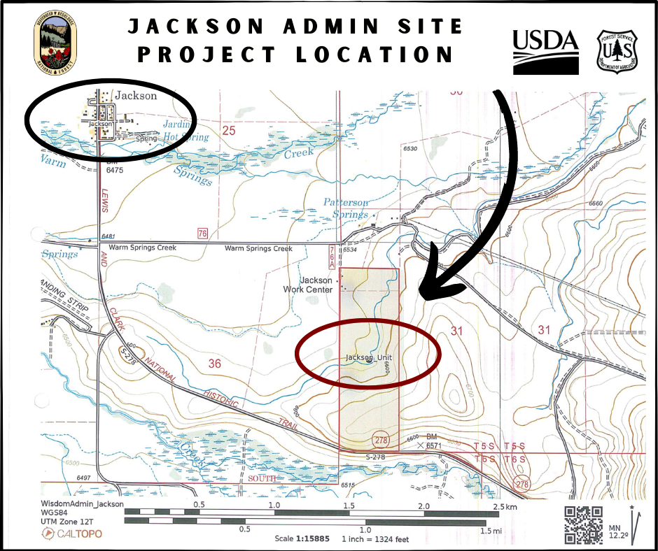
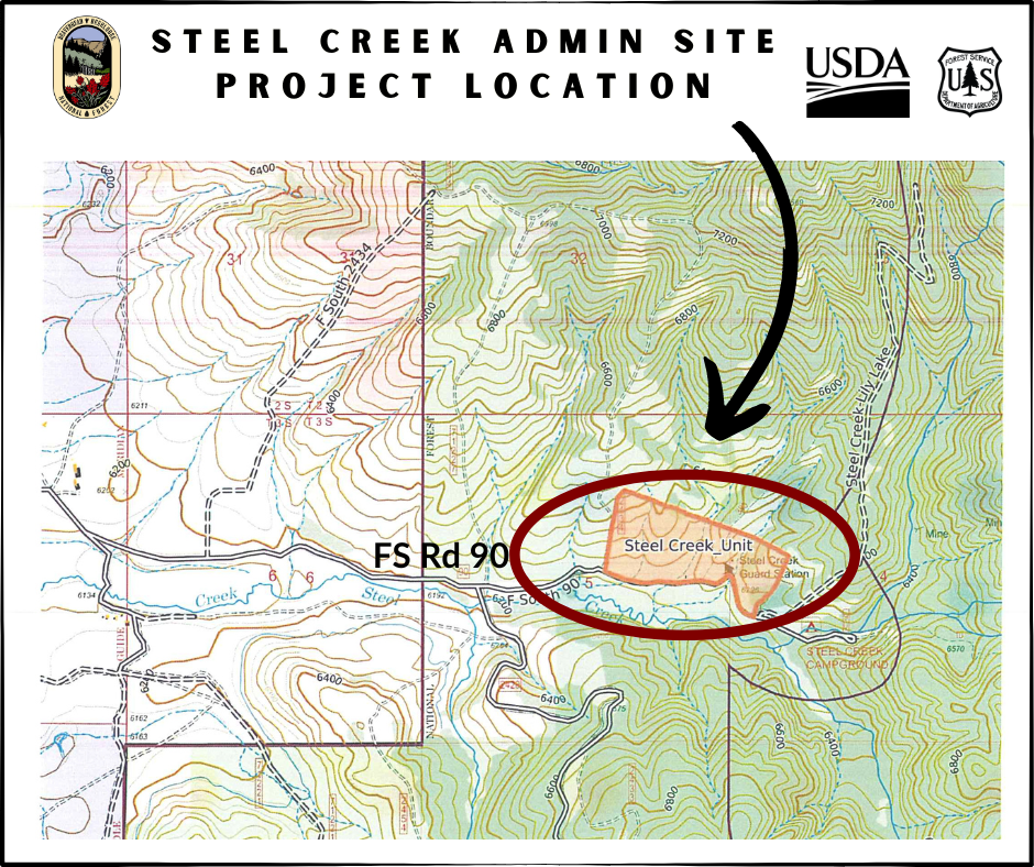
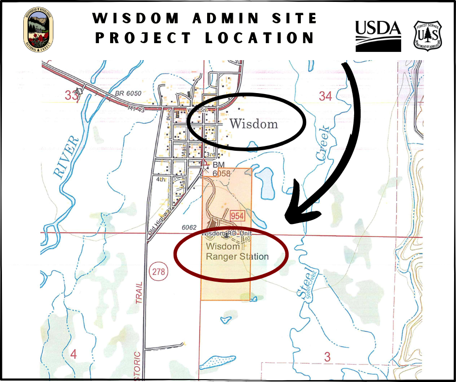
🔥Wisdom Ranger District (Administrative Sites)
Firefighters and fuels crew members plan to ignite the Jackson Unit and the Wisdom Unit on Saturday, May 11th and the Steel Creek Unit on Sunday, May 12th. Collectively, these administrative units total approximately 270 acres. The purpose of the prescribed fire operations is to reduce fine fuel loading and to increase desirable forage for agency pack stock.
📍Jackson Unit – along Warm Springs Creek Road, 1 mile southeast of Jackson, MT.
📍Wisdom Unit – at Wisdom Ranger District, along FS Rd 300.
📍Steel Creek Unit – up Steel Creek Rd (FS Rd 90), 5 miles east of Wisdom, MT.
Smoke impacts are expected to be low; smoke may be visible from Highway 43 and Highway 278 and the towns of Wisdom and Jackson. Fuels within the units should consume quickly, and smoke will be dispersed by transport winds.
For updates or more information, contact the appropriate Ranger District offices.
Pintler Ranger District (406) 859-3211
Wisdom Ranger District (406) 689-3243
May 8, 2024 Prescribed Fire Update 05 08 2024
Related Incident:
Publication Type: Announcement
The Lolo National Forest will continue to conduct prescribed fire operations today, as weather and fuels conditions allow.
Plains/Thompson Falls Ranger District:
Firefighters plan to conduct up to 20 acres of hand pile burning created from hazardous tree removal in campgrounds. The pile burn is located near the Fishtrap and Dry Creek area. Smoke may be visible from Thompson Falls.
Seeley Ranger District:
The Seeley Ranger District will continue prescribed fire operations (pile burning) to reduce hazardous fuels from previous vegetation management operations. Prescribed fire operations will take place 4 miles northwest of Seeley. Smoke may be visible from Highway 83 and Seeley Lake.
Burning piles reduces hazardous fuels and contributes to the implementation of the Wildfire Crisis Strategy.
Forsythe II Prescribed Burn Morning Update 05 07 2024
Related Incident: Forsythe II Prescribed Burn
Publication Type: Announcement
Fire managers are monitoring conditions for potential ignition tomorrow, Wednesday May 8, on the Forsythe II Prescribed Burn. Ignitions will be contingent on appropriate weather conditions falling within the parameters of the burn plan, such as appropriate wind speeds and ignitable fuel moistures.
Since our first ignition date on April 15, fire managers have had three total days of ignitions on the Forsythe II project for this season so far. Those three days of ignitions have successfully treated approximately 122 acres, and fire managers hope to treat an additional 70 acres this season, if conditions allow. Due to the intricate nature of the prescribed fire planning process requiring multiple factors to align, significant planning and preparation may go into a prescribed fire ignition only for it to be called off, despite our firefighters being fully prepared. Ignition decisions are made in consideration with our team of fire management professionals in collaboration with partners such as the National Weather Service.
Because of the fuel content within this prescribed burn area, there may be notable smoke visible from the Forsythe II Prescribed Burn during these ignition periods. Residents and visitors in the area can expect to see smoke and flames when operations are underway. The following areas in particular may see and smell smoke during this burn: Lakeshore subdivision, Crescent Village, Crescent Meadows, Gross Reservoir, Walker Park Ranch, Miramonte, Wondervu, Eldorado Canyon State Park, and parts of eastern Boulder County.
Fire managers work closely with experts to minimize the impacts of smoke to the best extent possible. Air quality is carefully monitored before and during a prescribed fire and all prescribed burns comply with state air quality regulations to minimize impacts to communities. More information is available at https://www.colorado.gov/pacific/cdphe/wood-smoke-and-health
The public is advised to not call 911 regarding prescribed fire activity. Additional email notifications will be sent on days when burning is expected to begin. To receive these ignition updates, join our email list and select "Forest Health & Fire: North of Hwy 72 (Coal Creek Canyon) to Hwy 119 Boulder Canyon (Nederland and Magnolia areas)." These updates will also be posted here on our InciWeb page.
Settings - change map background and toggle additional layers
Filter - control incident types displayed on map.
Zoom to your location
Reset map zoom and position
Could not determine your location.
Show Legend
- Wildfire
- Prescribed Fire
- Burned Area
Response
- Other
American Creek Prescribed Fire
Unit Information
Incident Contacts
Little Yamsay Fire Update May 7, 2024 05 07 2024
Related Incident: Little Yamsay Fire
Publication Type: News
Little Yamsay Fire Update - May 7, 2024
Fire Information: 971-978-7899
Email: 2024.littleyamsay@firenet.gov
Size: 2,009 acres Location: 15 miles southeast of Chemult, OR near Klamath Marsh
Start Date: Detected April 20, 2024 Cause: Lightning Total Personnel: 92
Crews: 2 Engines: 5 Heavy Equipment: 6 Water Tenders: 4
This lightning-caused fire is being systematically and carefully expanded to treat the landscape with low-intensity fire for forest health and fuels reduction. Some of the benefits include;
- Enhancing meadows by reducing conifer encroachment and increasing wildlife forage
- Minimizing the spread of disease and insects in the forest
- Reducing fuel loading by consuming dead and downed woody material
- Reducing ladder fuels and stand density by eliminating small-density trees
“There’s a right time and a right place to implement this fire,” said Type 3 Incident Commander Jeff Thumm. “I think this is a great opportunity. It’s the right time. The weather is here, so we can be successful. It’s the right place to take advantage of the work that’s been done on the District and the Forest over the last couple of years.”
For more information as to why fire managers are encouraged to increase naturally-caused wildfires when appropriate, read Confronting the Wildfire Crisis Strategy: https://www.fs.usda.gov/sites/default/files/fs_media/fs_document/Confronting-the-Wildfire-Crisis.pdf
Line preparation continued during Monday’s operational shift with resources beginning work in the phase four block located on the west side of Silver Lake Highway. Heavy equipment cut and stacked fuels along roads systems that will serve as control lines. Hotshot crews felled standing dead trees close to roads on the phase 3 and phase 4 blocks.
Firefighters will implement firing operations when warm weather moves into the area and dries out fuels, which is expected to occur Wednesday or Thursday. Control line preparation will continue during Tuesday’s operational shift. Resources will also prepare the phase four block as a potential area to reintroduce fire into as conditions allow.
There are no closures or evacuations for the Little Yamsay Fire. Residents and visitors driving on Silver Lake Highway between Forest Roads 49 and 7645 are encouraged to drive responsibly and plan on delays as flaggers will be controlling traffic.
Social Media Links:
Inciweb: https://inciweb.wildfire.gov/incident-information/orfwf-little-yamsay-fire
Facebook: https://www.facebook.com/SCOFMPFIREINFO
YouTube: http://www.youtube.com/@scofmpfireinformation6729
Fremont-Winema NF Facebook: https://www.facebook.com/R6FWNF