
Little Yamsay Fire Update May 12, 2024 05 12 2024
Related Incident: Little Yamsay Fire
Publication Type: News
Little Yamsay Fire Update- May 12, 2024
Fire Information: 971-978-7899 Email: 2024.littleyamsay@firenet.gov
Size: 4,791 acres Location: 15 miles southeast of Chemult, OR near Klamath Marsh Start Date: Detected April 20, 2024 Cause: Lightning Total Personnel: 102 Crews: 3 Engines: 5 Heavy Equipment: 1 Water Tenders: 3
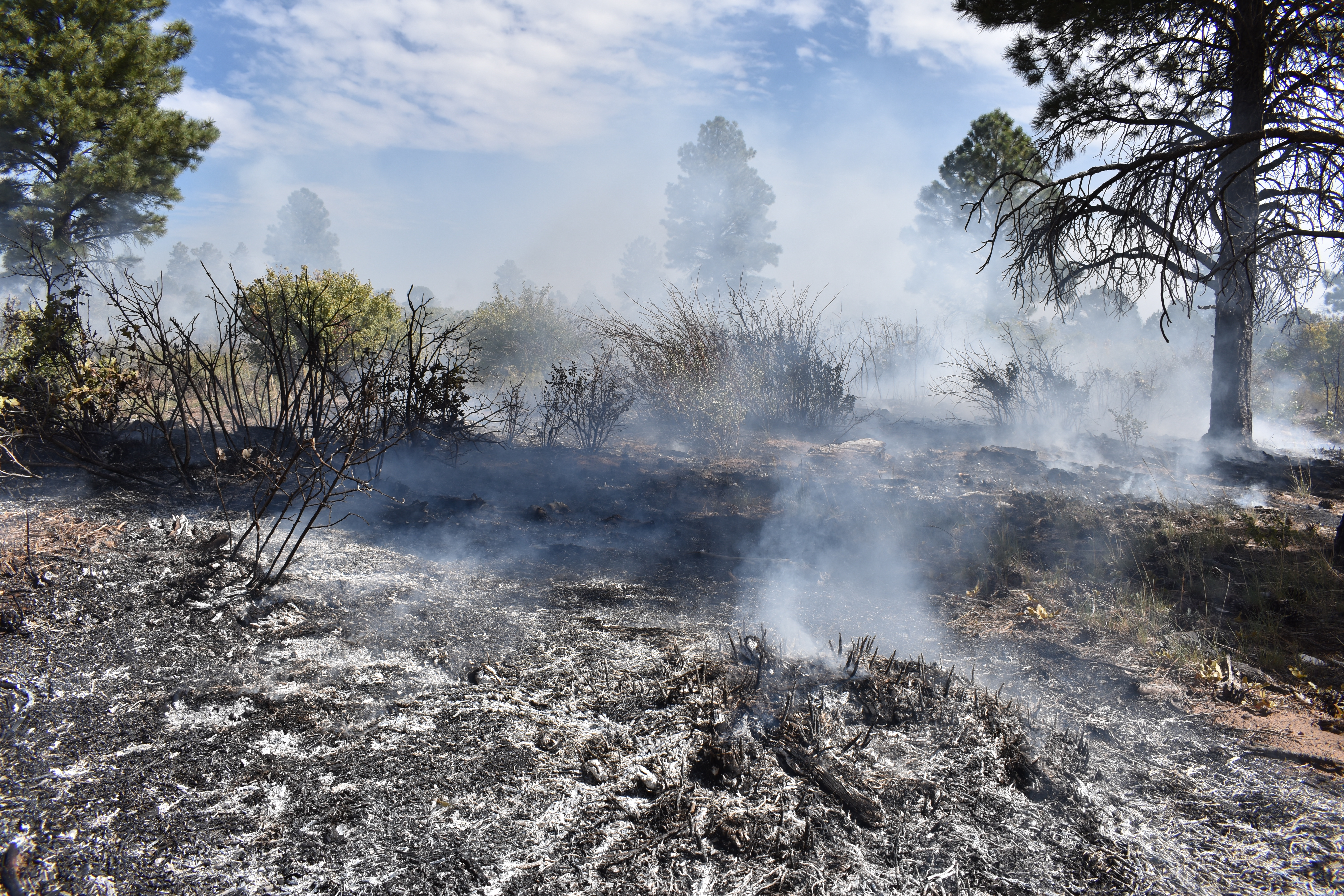
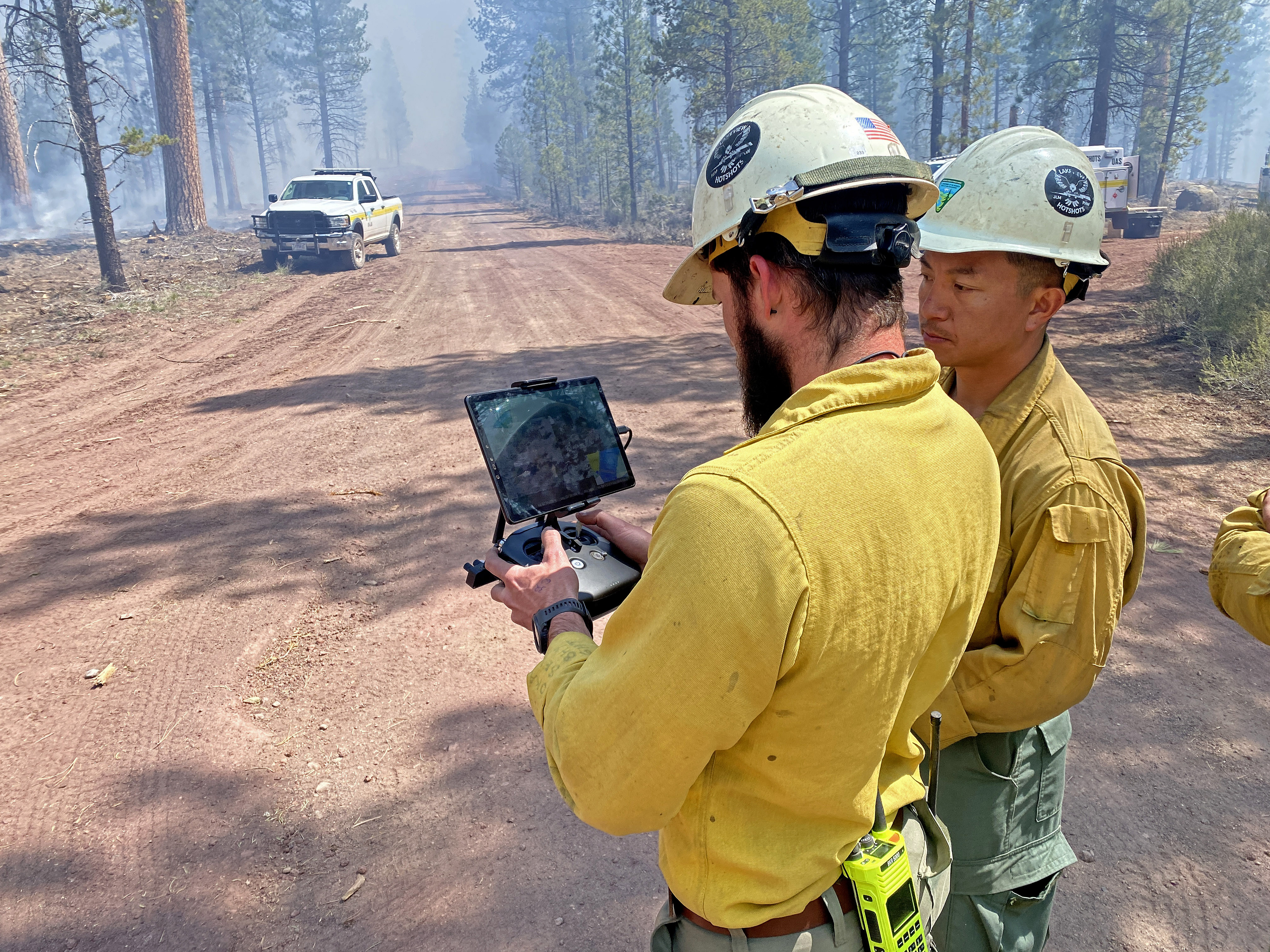
Crews completed roughly 1,500 acres of firing operations in phase 3 during Saturday’s shift. Favorable wind from the west kept smoke away from the Silver Lake Highway and allowed firefighters to work from east to west, carefully and methodically introducing fire onto the landscape. LaGrande, Union, and Lakeview Interagency Hotshot Crews utilized drip torches along roadways and Unmanned Aircraft Systems for firing within the interior in order to facilitate treatments in a coordinated manner.
Sunday, crews hope to complete firing operations on phase 3, closing in on the southwest corner of the planned treatment area. Several engine crews are in place to hold the fire within established control lines and protect legacy Ponderosa Pines by spraying out pre-existing fire scars or cat faces that catch fire.
Please use caution when travelling along the Silver Lake Highway. Drive slowly and adhere to signs on the side of the road. Firefighters will be working in close proximity to the roadway and visibility may be limited. Near the fire area, a pilot car will escort vehicles one-way to reduce the flow of traffic near the firing operations.
While these treatments may output significant smoke, fire activity is still consuming mostly ground fuels, brush, and ladder fuels. Larger ponderosa pines have adapted to fire- they have biological characteristics that allow them to withstand less severe ground fire. A regular cycle of low intensity burning enhances the health of these trees by reducing competitive plants, slowing the spread of insects and disease, and recycling nutrients to enhance soil health. A more open overstory allows light to enhance the growth of grasses on the forest floor, attracting wildlife and providing forage for deer and elk. As the narrative of “fighting” fire shifts in the west, utilizing natural starts as an opportunity to re-introduce a natural fire regime will be necessary to promote forest health, thus “fighting” large and destructive wildfires.
There are no closures or evacuations for the Little Yamsay Fire. Residents and visitors traveling to the area are encouraged to drive responsibly as emergency firefighter vehicles will be present. Expect delays as traffic control may be implemented due to smoke and/or hazards.
Facebook: https://www.facebook.com/SCOFMPFIREINFO
Inciweb: https://inciweb.wildfire.gov/incident-information/orfwf-little-yamsay-fire YouTube: http://www.youtube.com/@scofmpfireinformation6729
Fremont-Winema NF Facebook: https://www.facebook.com/R6FWNF
Horse Fire Daily Update, May 11, 2024 05 11 2024
Related Incident: Horse Fire AZTNF
Publication Type: News
Start Date: 05/05/2024 Location: Cave Creek Ranger District at MM 8 off Horseshoe Lake Road
Cause: Human-caused Acres: 512 Containment: 50%
Evacuations: Horseshoe Lake Campground
Structures: 0 Destroyed: 1 corral
Today’s Activity: All forward progress has been stopped although fuels continue to smolder in the interior of the fire. Fire crews will continue with mop up and have started suppression repair. We ask the public to avoid the Horseshoe Dam and Lake area for their own safety and to allow firefighters to work safely. Public and firefighter safety is always our top priority. In addition, please do not fly drones near or over a wildfire. Drones and firefighting aircraft are a dangerous mix and could lead to accidents or slow down wildfire suppression. If you fly, we can’t.
Closure: The road closure is still in effect for the entire portion of NFSR 205, also known as Horseshoe Dam Road, starting from NFSR 19, also known as Bartlett Dam Road and motorized trails within the St. Clair OHV area through June 7, 2024, until 6 p.m., unless rescinded. For the safety of firefighters and the public, please avoid the area during fire suppression operations. Click to view the closure order and map.
Weather: The dry conditions and breezes Saturday afternoon may lead to brief elevated fire weather conditions. Temperatures Saturday will be seasonal with afternoon highs in the mid to upper 80’s. Skies will remain mostly clear with no rain in the forecast.
Resources and Personnel Assigned: 143
Incident Information:
https://inciweb.wildfire.gov/incident-information/aztnf-horse-fire-aztnf
Twitter: https://twitter.com/TontoForest
Facebook: https://www.facebook.com/TontoNationalForest
Instagram: https://www.instagram.com/tontonationalforest/
Public Info: 602-428-5397
Media: 480-647-8082 & 530-260-6322
Little Yamsay Fire Update May 11, 2024 05 11 2024
Related Incident: Little Yamsay Fire
Publication Type: News
Little Yamsay Fire Update- May 11, 2024
Fire Information: 971-978-7899
Email: 2024.littleyamsay@firenet.gov
Size: 3,278 acres Location: 15 miles southeast of Chemult, OR near Klamath Marsh
Start Date: Detected April 20, 2024 Cause: Lightning Total Personnel: 106
Crews: 3 Engines: 5 Heavy Equipment: 3 Water Tenders: 3
Firing operations took a pause on Friday while crews ensured phases one and two are secured and will remain within control lines. Saturday, firing operations are planned to continue for phase three, in which firefighters are looking to complete 2,000 more acres of treatment. These operations will keep promoting low-intensity fire that consumes ground and ladder fuels.
However, smoke may be visible off of Highway 97 and in the surrounding communities. Please adhere to signs along the roadway and drive slowly when travelling along the Silver Lake Highway near the fire area. Smoke will tend to settle in the evenings and may be present along roadways in the mornings.
Upon completion of all phases of the Little Yamsay Fire, in combination with the footprint of the 2023 Dillon Creek Fire to the north, there will be a nearly 10,000-acre buffer of treated land off of the Silver Lake Highway. This treated land will more closely resemble its historic form, with a reduction in woody ground debris, more widely spaced large pines, and less of a chance for future ground fire to travel into the forest canopy.
Reintroducing fire to a fire adapted landscape, in the right place at the right time, will be a key component moving forward to restore the health of forests in the western United States. The condition of forests outside of a natural fire regime is outlined in the Wildfire Crisis Strategy. As read in the document, deprived of fire for far too long, many fire-adapted western forests are in poor and declining health. Degraded and overgrown, many are prone to disastrous wildfires that threaten lives, homes, communities, and natural resources. Counterintuitively, less regular fire over the last 100 years has resulted in larger, more destructive wildfires. One way to begin the reversal process is to tactically utilize an early season natural ignition source to expand a fire’s footprint before conditions are too hot and dry.
There are no closures or evacuations for the Little Yamsay Fire. Residents and visitors traveling to the area are encouraged to drive responsibly as emergency firefighter vehicles will be present. Expect delays as traffic control may be implemented due to smoke and/or hazards.
Facebook: https://www.facebook.com/SCOFMPFIREINFO
Inciweb: https://inciweb.wildfire.gov/incident-information/orfwf-little-yamsay-fire
YouTube: http://www.youtube.com/@scofmpfireinformation6729
Fremont-Winema NF Facebook: https://www.facebook.com/R6FWNF
East Zone Roadside Underburn Update #1 05 11 2024
Related Incident:
Publication Type: Announcement
Fire crews completed 8.5 acres of prescribed fire near Boca Reservoir yesterday, May 10. Ignitions are planned to continue today, May 11.
May 11, 2024 Prescribed Fire Update 05 11 2024
Related Incident:
Publication Type: Announcement
The Lolo National Forest may conduct prescribed fire operations in several locations across the Forest this weekend, as weather and fuels conditions allow.
Ninemile Ranger District:
The 67-acre South Fork Fish project location is approximately 15 miles south of Tarkio and 9 miles northwest of Lolo Hot Springs in the main Fish Creek drainage. Smoke will likely be seen from Fish Creek Road 343 and Owl Creek Road 5505. Engines and firefighters will be utilizing Road 343 and Road 5505, please use caution and slow down.
Plains/Thompson Falls Ranger District:
The Clear Creek project area is located 6 miles west of Thompson Falls. The area planned for treatment is approximately 50 acres in size. Smoke may be visible from Thompson Falls, Plains, and surrounding communities.
Superior Ranger District:
Firefighters and fuels crew members plan to ignite the Camelflage unit on Saturday, May 11th and Sunday, May 12th, as conditions allow. The Camelflage unit is located 4 miles west of St. Regis near Boyd Mountain and is approximately 14 acres. The purpose of the prescribed fire operations is to reduce the fuel loading created from previous management operations.
Prescribed fire will be implemented in compliance with Montana air quality standards and coordinated with the Montana Department of Environmental Quality and the appropriate county health departments to minimize the impacts of smoke. Check air quality near you on the Fire and Smoke Map online at fire.airnow.gov.
Firefighters will be on-site, patrolling the project areas until the burning operation is complete and called out.
Clints Wellarea roads open following temporary closure for Wolf Fire 05 10 2024
Related Incident:
Publication Type: News
Clints Well-area roads open following temporary closure for Wolf Fire
Motorists asked to remain cognizant of smoke impact in area
HAPPY JACK, Ariz., May 10, 2024 — Fire and road managers have re-opened Clints Well-area roads following a temporary closure due to firing operations on the Wolf Fire, located on the Coconino National Forest’s Mogollon Rim Ranger District.
State Route (SR) 87 has opened in both directions between the SR 260 junction at milepost 278.5 and the Lake Mary Road junction at milepost 290.5.
While the road closure has been lifted, traffic delays along SR 87 and other area roads, such as Lake Mary Road, will likely persist.
Intermittent closures of area roads may occur throughout fire management should smoke impede roadway visibility.
Closures of SR 87 and other roads may include temporary full closures, reduction to single-lane traffic and the potential for pilot car guidance.
Reduced speed limits remain in place while firing operations continue on the Wolf Fire, and motorists are reminded to abide by all posted signage and remain cognizant of firefighters working along roadways in the fire area.
Motorists are advised to check road status prior to traveling via the Arizona Department of Transportation’s road status website at az511.gov, the AZ511 app or by calling 511.
Forest visitors are advised to check forest road status via the Coconino National Forest’s website at coconinonationalforest.us prior to traveling on forest roads.
The Wolf Fire is a lightning-caused fire that began 3 miles northwest of Clints Well. It was first reported April 29.
Up-to-date information regarding the Wolf Fire is available on InciWeb at inciweb.wildfire.gov.
Horse Fire Daily Update, May 10, 2024 05 10 2024
Related Incident: Horse Fire AZTNF
Publication Type: News
Start Date: 05/05/2024 Location: Cave Creek Ranger District at MM 8 off Horseshoe Lake Road
Cause: Human-caused Acres: 512 Containment: 29%
Evacuations: Horseshoe Lake Campground
Structures: 0 Destroyed: 1 corral
Today’s Activity: Fire crews are continuing mop up operations. Mop up describes the hard physical labor process of extinguishing and removing burning materialnear control lines down to the mineral soil, felling fire damaged trees, and cooling ash pits to make the fire less likely to escape and to reduce residual smoke. With the weekend here please make sure your campfires are completely dead out. Also, make sure you have no dragging chains when towing your recreational vehicles.
Closure: The road closure is still in effect for the entire portion of NFSR 205, also known as Horseshoe Dam Road, starting from NFSR 19, also known as Bartlett Dam Road and motorized trails within the St. Clair OHV area through June 7, 2024, until 6 p.m., unless rescinded. For the safety of firefighters and the public, please avoid the area during fire suppression operations. Click to view the closure order and map.
Weather: Seasonally dry conditions will continue with some degree of gusty afternoon winds will be common at the fire site for the next couple of days. Minimum relative humidity levels near 10% and only fair overnight recoveries should be common.
Resources and Personnel Assigned: 155
Incident Information:
https://inciweb.wildfire.gov/incident-information/aztnf-horse-fire-aztnf
Twitter: https://twitter.com/TontoForest
Facebook: https://www.facebook.com/TontoNationalForest
Instagram: https://www.instagram.com/tontonationalforest/
Public Info: 602-428-5397
Media: 480-647-8082 & 530-260-6322
Firefighters at West Dolores Rim prescribed burn complete 560 acres on May 9, 2024 05 10 2024
Related Incident:
Publication Type: Announcement
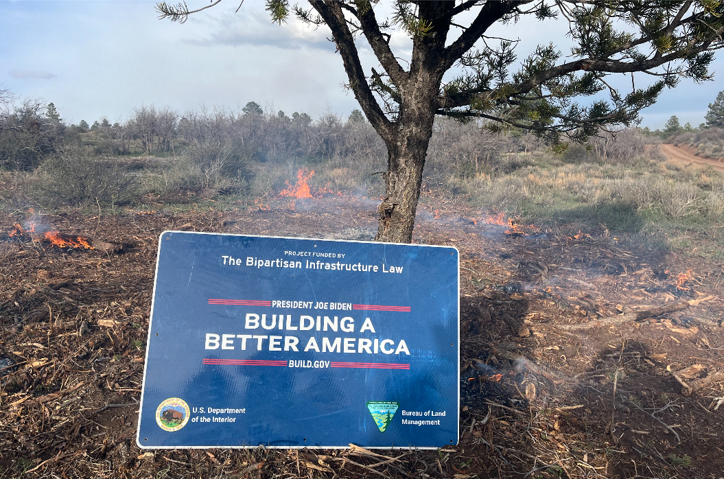
Yesterday, firefighters on the West Dolores Rim Prescribed Burn successfully completed 560 acres with favorable conditions. Morning temperatures were cooler than expected, but once it warmed up it allowed firefighters the conditions to complete 2 units on BLM Tres Rios Field Office managed lands. Today, firefighters will continue to secure the perimeter and monitor internal burning within the units. While smoke may be visible in the area at times, most of the smoke will lift and dissipate during the warmest parts of the day. Expect visible smoke in the area for several days as vegetation in the interior continues to smolder.
Fire managers will continue to look for other opportunities this spring to complete additional units on the West Dolores Rim Project. This project is funded by the Bipartisan Infrastructure Law (BIL) to reduce hazardous vegetation while enhancing woodland health and functionality.
For more information on BLM Southwest District prescribed burn treatments visit, InciWeb-Southwest District BLM Prescribed Fire https://inciweb.wildfire.gov/ and follow BLM Southwest District Facebook and Twitter @SWD_Fire
Little Yamsay Fire Update May 10, 2024 05 10 2024
Related Incident: Little Yamsay Fire
Publication Type: News
Little Yamsay Fire Update- May 10, 2024
Fire Information: 971-978-7899
Email: 2024.littleyamsay@firenet.gov
Size: 3,200 acres Location: 15 miles southeast of Chemult, OR near Klamath Marsh
Start Date: Detected April 20, 2024 Cause: Lightning Total Personnel: 106
Crews: 3 Engines: 5 Heavy Equipment: 3 Water Tenders: 3
Smoke was widespread Thursday and may be visible from highway 97 and surrounding communities for the next several days until all firing operations are complete sometime into next week. While the smoke output does appear thick in areas, firing operations on the Little Yamsay Fire remain at a low intensity. Lingering smoke may settle into the valleys at night and into the morning.
One of the primary objectives from fire managers is to reduce fuel loading that could contribute to a catastrophic wildfire in summer months. Systematic firing operations that remove hazardous fuel loading in the spring may produce air quality impacts for a limited time. However, these efforts can prevent months of wildfire smoke from a large, destructive incident later in the summer.
Phase two of firing operations was successfully completed on the Little Yamsay Fire during Thursday’s operations, with firefighters continuing work on phase three. Working along existing roadways, crews were able to establish a solid buffer along the south edge of the fire, and promote consumption of ground and ladder fuels in the interior with unmanned aerial systems (UAS).
Friday, crews will work to secure and hold Thursday’s firing operation. Ensuring that the fire remains within control lines is the incident management team’s highest priority, with crews performing a thorough job checking roadways for lingering heat and extinguishing any burning material close to the perimeter.
Warmer weather and drier fuels are anticipated on Friday. The advancement of firing in phase three will commence as long as these weather conditions will allow fire activity to meet the objective of remaining at a low intensity.
There are no closures or evacuations for the Little Yamsay Fire. Residents and visitors traveling to the area are encouraged to drive responsibly as emergency firefighter vehicles will be present. Expect delays as traffic control may be implemented due to smoke and/or hazards.
Facebook: https://www.facebook.com/SCOFMPFIREINFO
Inciweb: https://inciweb.wildfire.gov/incident-information/orfwf-little-yamsay-fire
YouTube: http://www.youtube.com/@scofmpfireinformation6729
Fremont-Winema NF Facebook: https://www.facebook.com/R6FWNF
Hay Camp Prescribed Burn Postponed 05 10 2024
Related Incident: 2025 San Juan National Forest Prescribed Fire Program
Publication Type: Announcement
A prescribed burn of approximately 700 acres in the Hay Camp Mesa on the Dolores Ranger District, tentatively scheduled for May 10, has been postponed. Weather conditions will not be favorable. Fire managers will continue to look for favorable weather periods when the burn can be safely and effectively carried out. This site will be updated when and if the burn is rescheduled.