
Forsythe II Update week of 04 29 2024
Related Incident: Forsythe II Prescribed Burn
Publication Type: Announcement
The Forsythe II Prescribed Burn area received 6-8 inches of snow over the weekend of April 27-28. The perimeter of Unit 38C near 359.1 Winiger Ridge Road that was burned last week has been secured and this unit is now in patrol status. Fire crews are now doing planning and preparation work for potential ignitions for Unit 44, south of 97.1 Lazy Z Road. Appropriate conditions for an ignition period are not expected until the end of this week at the earliest.
For notifications on these ignitions, sign up for our email list and select "Forest Health & Fire: North of Hwy 72 (Coal Creek Canyon) to Hwy 119 Boulder Canyon (Nederland and Magnolia areas)". Additional information, including maps and videos describing this prescribed fire project, are posted here on our InciWeb page.
This active prescribed burn area remains closed to the public as fire crews monitor the area and work on preparations for the next unit.
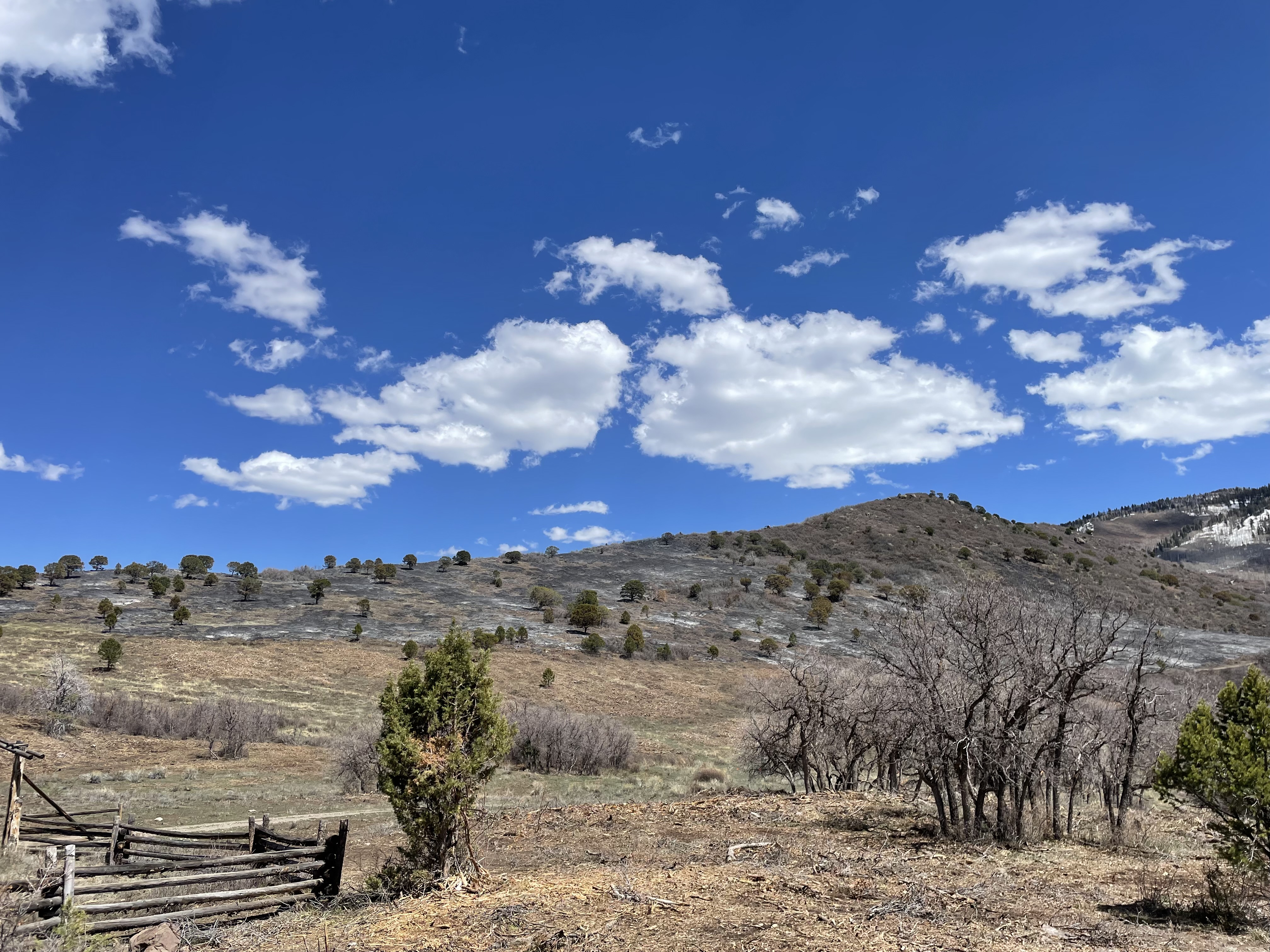
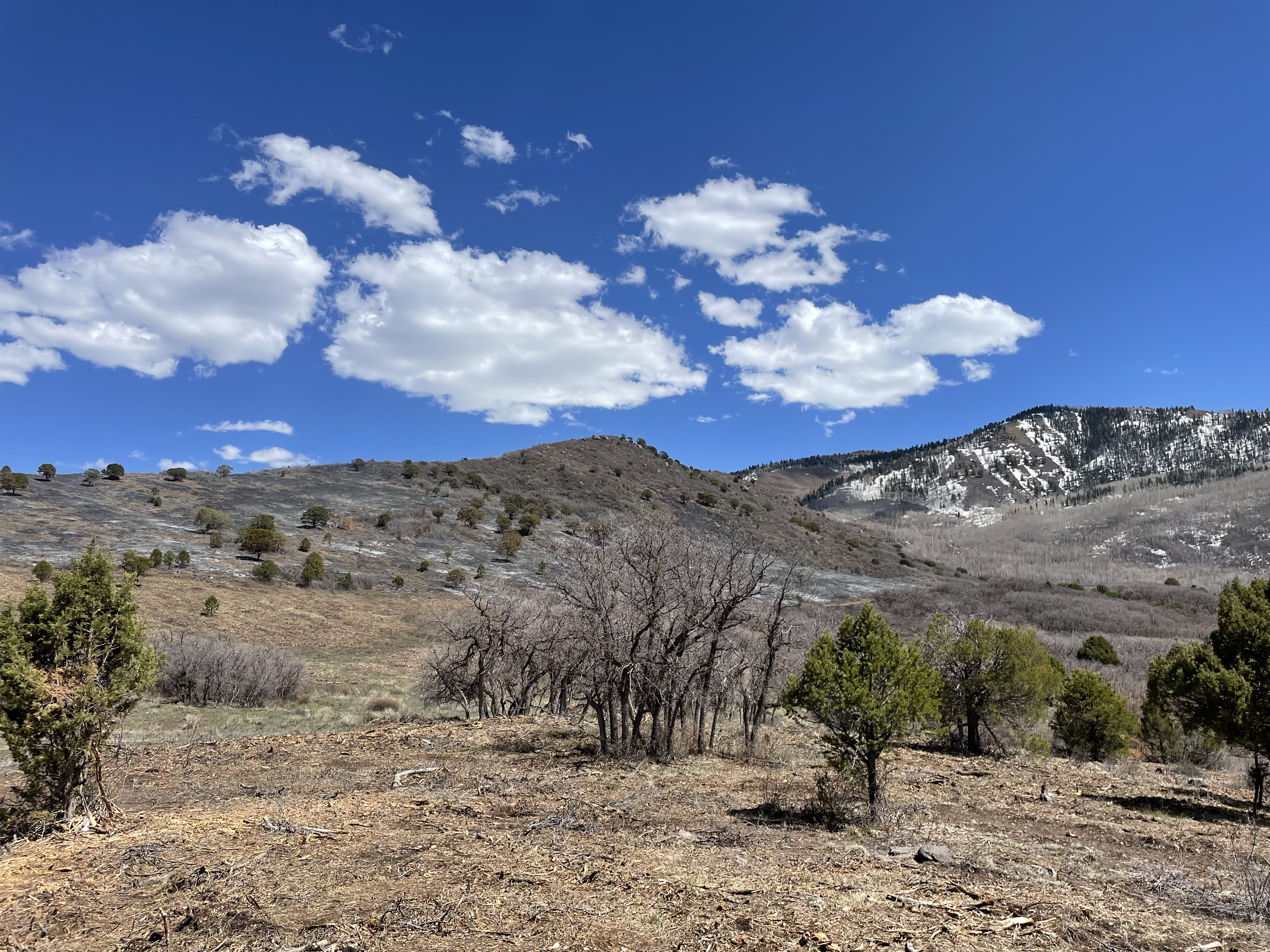
Updated: Prescribed fires planned this spring on Carpenter Ridge and West Dolores Rim 04 27 2024
Related Incident:
Publication Type: Announcement
Prescribed fires planned spring of 2024 on Carpenter Ridge and West Dolores Rim
MONTROSE, Colo. – The Bureau of Land Management (BLM) plans to conduct prescribed fire treatments this spring in the Tres Rios and Uncompahgre field offices. When conditions allow, firefighters will reintroduce fire to a fire-adapted ecosystem in a controlled manner to protect Ponderosa pine stands, enhance wildlife habitat, restore healthy forests and species diversity, and maintain a fire-resilient landscape.
The Carpenter Ridge project area is located two miles north of Paradox Valley, CO, between Q13 and R3 roads (Rim Rocker Trail route). Firefighters plan to burn 200 acres of oak brush and pine tree litter. “The Carpenter Ridge treatment will help break down forest litter and add nutrients back into the soil so that native plants can flourish and benefit wildlife,” said Fire Management Specialist Cameron Shaughnessy.
The West Dolores Rim project area is located seven miles east of Dove Creek. Firefighters will use hand ignitions and Unmanned Aircraft System (UAS) on 3,132 acres of pine needle cast and mountain brush leaf litter. “Reintroducing low intensity fire on West Dolores Rim will clear brush and needle cast that can prevent new plant growth, as well as decrease the likelihood of a large severe wildfire,” said acting Fire Management Specialist Tyler Corbin.
Prescribed fire mimics natural processes under appropriate weather and vegetative conditions, which improves forage for wildlife, increases plant diversity by creating breaks in the understory where native grasses and forbs can thrive, and effectively reduces hazardous vegetation while enhancing woodland health.
The projects are part of the BLM’s ongoing commitment to protect human health and safety while maintaining or enhancing forest and woodland health and functionality. The BLM obtained smoke permits from the Colorado State Air Pollution Control Division, which identify atmospheric conditions under which the burns can be implemented. Prescribed fire smoke may affect your health. For more information, visit https://www.colorado.gov/pacific/cdphe/wood-smoke-and-health.
More information on Southwest District prescribed fuel treatments https://inciweb.wildfire.gov/incident-information/cosjd-southwest-district-blm-prescribed-fire and follow our Facebook page https://www.facebook.com/BLMMontroseFireUnit or Twitter https://twitter.com/SWD_Fire
-BLM-
The BLM manages more than 245 million acres of public land located primarily in 12 western states, including Alaska, on behalf of the American people. The BLM also administers 700 million acres of sub-surface mineral estate throughout the nation. Our mission is to sustain the health, diversity, and productivity of America’s public lands for the use and enjoyment of present and future generations.
Baldy Mountain RX Update 04 24 2024
Related Incident: Baldy Mountain Landscape Resiliency and Habitat Improvement Project Prescribed Burn
Publication Type: Announcement
Firefighters are continuing to monitor the 112-acre #BaldyMountainRX in the Baldy Mountain Project area. Currently there is little to no smoke visible. Precipitation is forecasted for the area as early as this weekend. Firefighters will continue to patrol and monitor the prescribed fire area until it is officially declared out.
The goal of the Baldy Mountain Project is to restore the resiliency of the landscape for multiple species and the protection of wildland-urban interface. To learn more about the project, visit the website: https://www.nationalforests.org/regional-programs/rocky-mountain-region/baldy-mountain-landscape-resiliency-and-habitat-improvement-project
April 26, 2024 Prescribed Fire Update 04 26 2024
Related Incident:
Publication Type: Announcement
🙏A big thank you to our all partners (listed below) who helped and supported the Lolo National Forest accomplish over 600 acres of prescribed fire operations this week!
- Rocky Mountain Elk Foundation
- Bureau of Land Management
- Montana DNRC
- Missoula Rural Fire Department
- Frenchtown Rural Fire Department
- Missoula Smokejumpers, Lolo Hotshots, and Missoula Helitack
🔥 Without our partners, we would not be able to be as effective in using prescribed fire as a management tool to remove hazardous fuels, create a fire-adapted ecosystem, and restore wildlife habitat, mimicking the natural role of fire on the landscape.
💦 Ignitions are not planned for the next couple days due to forecasted weather. We will post again if conditions become favorable for new ignitions. Remember to go to https://inciweb.wildfire.gov for the most up to date fire information.
📷: Photo of the Frenchtown Face Unit, April 25, 2024
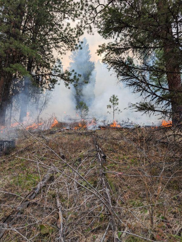
Forsythe II PM Update 04 25 2024
Related Incident: Forsythe II Prescribed Burn
Publication Type: Announcement
Ignitions are complete for today, Thursday, April 25, after successfully treating 67 acres at the Forsythe II prescribed burn. Firefighters will remain in the area to secure and monitor the perimeter of this burn unit.
Smoke remains visible in the Gross Reservoir area. Smoke may also be noticeable in eastern Boulder County this evening. We have added a video to this InciWeb Incident with additional information (click on the "Videos" tab above).
Fire managers work closely with experts to minimize the impacts of smoke. Air quality is carefully monitored before and during a prescribed fire and all prescribed burns comply with state air quality regulations to minimize impacts to communities. To learn more about the potential health impacts of smoke visit https://cdphe.colorado.gov/wood-smoke-and-your-health
Ignitions are not planned for the next several days due to forecasted weather. We will post again if conditions become favorable for new ignitions. Remember check here in InciWeb for the most up to date fire information.
Burning operations complete Greenbrier Ranger Station in Bartow. 04 25 2024
Related Incident:
Publication Type: Announcement
Burning operations are complete on a brush pile at the Greenbrier Ranger Station in Bartow.
Forsythe II AM Update 04 25 2024
Related Incident: Forsythe II Prescribed Burn
Publication Type: Announcement
Fire crews have completed a test fire and verified that conditions are good for another day of prescribed fire ignitions today, Thursday, April 25, for the Forsythe II Prescribed burn area. Smoke may be notably visible in the Gross Reservoir area as well as along the Front Range.
Fire managers work closely with experts to minimize the impacts of smoke. Air quality is carefully monitored before and during a prescribed fire and all prescribed burns comply with state air quality regulations to minimize impacts to communities. To learn more about the potential health impacts of smoke visit www.colorado.gov/pacific/cdphe/wood-smoke-and-health.
Additional email notifications will be sent out periodically during ignition periods. To receive updates, make sure to join our email list and select "Forest Health & Fire: North of Hwy 72 (Coal Creek Canyon) to Hwy 119 Boulder Canyon (Nederland and Magnolia areas)". Additional information, including maps and project details for the Forsythe II prescribed burn plan, can be found here on InciWeb.
Have questions? Email ARPFireInfo@usda.gov.
Burning Operations Have Begun Greenbrier Ranger Station 04 25 2024
Related Incident:
Publication Type: Announcement
Burning operations have begun! Ignition has begun on a brush pile at the Greenbrier Ranger Station in Bartow. Smoke will be visible.
April 25, 2024 Prescribed Fire Update 04 25 2024
Related Incident:
Publication Type: News
Yesterday was a successful day of prescribed fire operations across many of our districts, work will continue today and throughout the rest of this week, pending conditions.
Ninemile Ranger District: Firefighters made good progress yesterday on the Frenchtown Face unit and will continue up to 75 acres of prescribed fire operations today. The Frenchtown Face unit is located approximately 9 miles north of Ninemile Road near the Stoney Creek drainage. The Smoke will likely be visible from Alberton, Ninemile, Huson and Frenchtown.
Plains/Thompson Falls Ranger District: Prescribed fire operations will continue on the Clear Creek units, located 6 miles west of Thompson Falls. Firefighters plan to burn up to 75 acres on two units. Smoke may be visible from Thompson Falls, Plains, and surrounding communities.
Seeley Ranger District: The 66-acre prescribed fire unit is located southeast of the community of Seeley Lake; east of Highway 83 between mile markers 10 and 13. Smoke may be visible from Hwy 83 for the duration of the burn.
Superior Ranger District: Firefighters will conduct up to 500 acres of prescribed burning on two different units, located 4 12 Mile and Flat Rock Creek located approximately 3 miles north of Cabin City. This prescribed burn will utilize aerial ignitions to reduce fuel from previous management operations. The helibase will be located 4 miles up Tamarack Creek. Residents will see a helicopter in the area. Smoke could be visible from I-90, St. Regis, and possibly Plains. Smoke should disperse following ignition but may settle along drainages and in lower elevations in the overnight hours.
Prescribed fire will be implemented in compliance with Montana air quality standards and coordinated with the Montana Department of Environmental Quality and the appropriate county health departments to minimize the impacts of smoke. Check air quality near you on the Fire and Smoke Map at fire.airnow.gov.
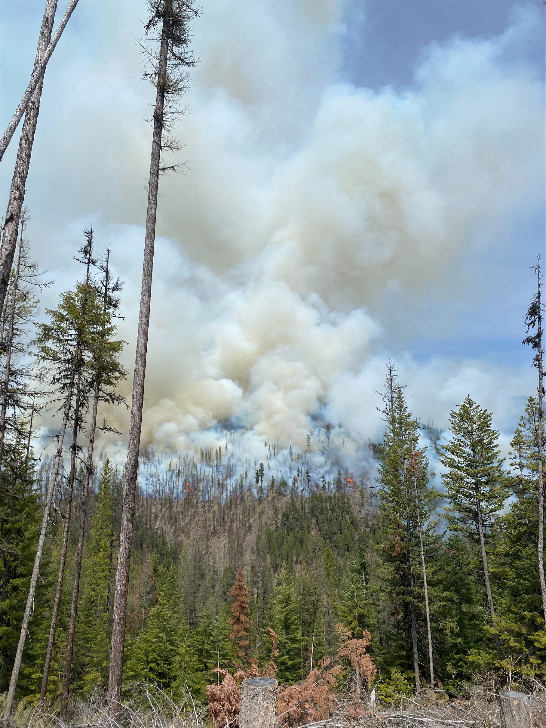
Prescribed fire on the Superior Ranger District, April 23, 2024
Forsythe II PM Update 04 24 2024
Related Incident: Forsythe II Prescribed Burn
Publication Type: Announcement
Ignitions are complete for today, Wednesday, April 24, after successfully treating 30 acres at the Forsythe II prescribed burn. Firefighters will remain in the area to secure and monitor the perimeter of this burn unit. Due to unforecasted overnight rain last night, burning conditions resulted in less smoke than was expected for today. Smoke may remain visible in the Gross Reservoir area.
Fire crews are monitoring conditions for possible ignitions again tomorrow, Thursday, April 25. If drying trends continue, the potential for notable smoke will remain.
Additional email notifications will be sent out periodically during ignition periods. To receive updates, make sure to join our email list and select "Forest Health & Fire: North of Hwy 72 (Coal Creek Canyon) to Hwy 119 Boulder Canyon (Nederland and Magnolia areas)". Additional information, including maps and project details for the Forsythe II prescribed burn plan, can be found here on InciWeb.
Have questions? Email ARPFireInfo@usda.gov.