
Little Yamsay Fire Update May 5, 2024 05 05 2024
Related Incident: Little Yamsay Fire
Publication Type: News
Little Yamsay Fire Update
May 5, 2024
Fire Information: 971-978-9558
Email: 2024.littleyamsay@firenet.gov
Size: 2,009 acres Location: 15 miles southeast of Chemult, OR near Klamath Marsh
Start Date: Detected April 20, 2024 Cause: Lightning Total Personnel: 120
Crews: 3 Engines: 5 Heavy Equipment: 8 Water Tenders: 4
Snow and rain fell over the fire area most of the day Saturday, saturating fuels and postponing firing operations. While waiting for favorable weather conditions to resume firing in phases two and three, assigned resources focused on fuels reduction along road systems and mop up along control lines. Engine crews extinguished heat in and around the root systems and cat faces of large-diameter Ponderosa pines to limit mortality of these heritage trees.
Weather will continue to play a factor in determining our operational success. During Sunday’s shift, firefighters and heavy equipment will prepare control lines for phase 3. Engine crews will continue mopping up, protecting large pines, and securing lines.
VEHICLE TREE STRIKE NARRATIVE: As firefighters were traveling to the fireline Saturday morning at approximately 7:30 am, a tree fell onto the cab of a vehicle contacting the windshield. None of the four passengers sustained injuries and were evaluated by incident medical staff. The vehicle sustained significant damage and needed to be towed. The tree was determined to be a live 19-inch (Diameter at Base Height) Ponderosa Pine that failed due to interior rot and strong winds from the cold front.
According to Safety Officer Cory Thompson, “We had a tree strike that could have been a lot worse. The employees are good, a little shaken up. It was a green tree and it was rotten in the middle. If you looked at that tree you probably could not identify that it would have been a hazard tree.”
There are no closures or evacuations for the Little Yamsay Fire. Residents and visitors are encouraged to stay out of the fire area and reminded to drive carefully as emergency vehicles and smoke may be present on the roads.
Social Media Links:
Inciweb Page: https://inciweb.wildfire.gov/incident-information/orfwf-little-yamsay-fire
South Central Oregon Fire Management Partnership (SCOFMP) Facebook: https://www.facebook.com/SCOFMPFIREINFO
SCOFMP YouTube Channel: http://www.youtube.com/@scofmpfireinformation6729
Fremont-Winema National Forest Facebook: https://www.facebook.com/R6FWNF
Fremont-Winema National Forest website: https://www.fs.usda.gov/fremont-winema/
Little Yamsay Fire Update May 4, 2024 05 04 2024
Related Incident: Little Yamsay Fire
Publication Type: News
Little Yamsay Fire Update May 4, 2024
Fire Information: 971-978-9558
Email: 2024.littleyamsay@firenet.gov
Size: 2,009 acres Location: 15 miles southeast of Chemult, OR near Klamath Marsh Start Date: Detected April 20, 2024 Cause: Lightning Total Personnel: 120 Crews: 3 Engines: 5 Heavy Equipment: 8 Water Tenders: 4
A combination of optimal weather, dry fuels, and skilled resources aligned Friday leading to a productive day where firing operations treated an additional 1,350 acres. The fire consumed needle cast, brush, and dead and downed logs while torching out small- diameter conifers. The footprint of the Little Yamsay Fire remains within established control lines.
During Friday’s operational shift, La Grande Interagency Hotshot Crew (IHC), assisted by aerial ignitions from an Unmanned Aircraft Systems (UAS) module, completed ignitions on the phase one and brought fire into phase three, treating more than 700 acres.
Baker River IHC, Union IHC, and an additional UAS module commenced firing operations on phase two. Baker River hand lit the east flank with drip torches and then worked their way north along roads, Union lit the south road system moving westward. The UAS module dropped incendiary devices, also known as dragon eggs, to burn the interior portion. An estimated 550 acres or half of phase two were treated.
Engine crews cooled down large-diameter pines and patrolled the roads to ensure no fire crossed the lines. Heavy equipment continued fuels reduction along Forest Road 49.
A cold front arrived Friday night and into Saturday morning bringing mixed snow and rain to the fire area. With the change in weather, firefighters will focus on preparing lines for firing operations in phases two and three as conditions allow.
There are no closures or evacuations for the Little Yamsay Fire. Residents and visitors are encouraged to stay out of the fire area and reminded to drive carefully as emergency vehicles and smoke may be present on the local roads.
Social Media Links:
South Central Oregon Fire Management Partnership (SCOFMP) Facebook: https:// www.facebook.com/SCOFMPFIREINFO
SCOFMP YouTube Channel: http://www.youtube.com/@scofmpfireinformation6729
Fremont-Winema National Forest Facebook: https://www.facebook.com/R6FWNF
Fremont-Winema National Forest website: https://www.fs.usda.gov/fremont-winema/
Little Yamsay Fire Update May 3, 2024 05 03 2024
Related Incident: Little Yamsay Fire
Publication Type: News
Little Yamsay Fire Update May 3, 2024
Fire Information: 541-977-2756
Email: 2024.littleyamsay@firenet.gov
Size: 633 acres
Location: 15 miles southeast of Chemult, OR near Klamath Marsh
Start Date: Detected April 20, 2024
Cause: Lightning
Total Personnel: 120
Crews: 3 Engines: 5 Heavy Equipment: 8 Water Tenders: 4
Cooler weather with light rain moved across the fire area early Thursday leading to an increase in fuel moisture that hampered the ability to continue firing operations. An afternoon drying trend ensued, which allowed firefighters to ignite fuels around cultural and forest resources with low-intensity fire to protect these values at risk.
Engine crews patrolled and cooled areas of heat along Forest Roads 7644 and 7645 as well as the 300 spur, all of which are control lines for the phase one block. They also helped extinguish fire in pre-existing fire scars (cat faces) and roots systems of large Ponderosa Pines to prevent the trees from being damaged or killed.
Crews assisted with mop up and shifted their effort to preparing control lines for future firing operations by thinning along roads and handlines. Heavy equipment, including feller bunchers and masticators, continued with fuels reduction work along Forest Road 49, which will serve as a control line on the southern perimeter of this wildfire.
Friday’s firing operations will be determined by weather and fuel receptivity. If the needle cast, brush, and other surface fuels carry fire, then Baker River, La Grande, and Union Hotshot will pick up where they left off in the phase one block and possibly bring fire into the phase two block located directly south of phase one. Fuels reduction efforts and line preparation will be the primary missions in the phase three block.
Smoke may impact the Chiloquin, Bly, Chemult, and Klamath Falls areas due to wildfire activity as well as prescribed fires simultaneously being conducted on the Forest.
There are no closures or evacuations associated with the Little Yamsay Fire. However, residents and visitors are encouraged to stay out of the fire area and reminded to drive carefully as emergency vehicles may be present on the roads.
Social Media Links:
South Central Oregon Fire Management Partnership (SCOFMP) Facebook: https:// www.facebook.com/SCOFMPFIREINFO
SCOFMP YouTube Channel: http://www.youtube.com/@scofmpfireinformation6729 Fremont-Winema National Forest Facebook: https://www.facebook.com/R6FWNF Fremont-Winema National Forest website: https://www.fs.usda.gov/fremont-winema/
Little Yamsay Fire Update May 2, 2024 05 02 2024
Related Incident: Little Yamsay Fire
Publication Type: News
Little Yamsay Fire Update May 2, 2024
Fire Information: 541-977-2756
Email: 2024.littleyamsay@firenet.gov
Size: 633 acres
Total Personnel: 115
Location: 15 miles southeast of Chemult, OR on the Fremont-Winema NF
Start Date: Detected April 20, 2024
Cause: Lightning
With favorable weather conditions, firefighters utilized firing operations to burn an additional 365 acres in a coordinated effort to promote forest health and fuels reduction. The plan for this naturally-ignited wildfire is to safely and systematically return fire to three predetermined blocks of land, which will result in a 6,000-acre footprint within established control lines.
Two Interagency Hotshot Crews (IHC) commenced firing operations in the northeast portion of the fire referred to as the phase one. Baker River IHC, assisted by of a Unmanned Aircraft Systems (UAS) or drone, burned approximately 265 acres progressing south along the 300 spur road and west off of Forest Road (FR) 7644. The UAS supported ground personnel by dropping plastic sphere incendiary devices to help access areas away from the road system. LaGrande IHC burned an additional 100 acres on the northeast portion of the phase one block bringing fire to the west along FR 7645.
In the phase two block, firefighters continued preparing containment lines by thinning fuels along the FR 4975. Excavators with masticator heads further reduced fuels in this area. Heavy equipment prepared control lines along the 950 spur located on the southern perimeter of phase three.
The primary objective for Thursday’s operational shift is to complete ignitions in phase one and ensure the fire remains within containment lines. A cold front is forecasted to move into the fire area Thursday afternoon, which may hinder firing operations.
Smoke may impact the Chiloquin, Bly, Chemult, and Klamath Falls areas due to wildfire activity as well as prescribed fires simultaneously being conducted on the Forest.
There are no closures or evacuations associated with the Little Yamsay Fire. However, residents and visitors are encouraged to stay out of the fire area and reminded to drive carefully as emergency vehicles may be present on the roads.
Social Media Links:
South Central Oregon Fire Management Partnership (SCOFMP) Facebook: https:// www.facebook.com/SCOFMPFIREINFO
Fremont-Winema National Forest Facebook: https://www.facebook.com/R6FWNF Fremont-Winema National Forest website: https://www.fs.usda.gov/fremont-winema/
Little Yamsay Fire Update May 1, 2024 05 02 2024
Related Incident: Little Yamsay Fire
Publication Type: News
Little Yamsay Fire Update May 1, 2024
Fire Information: 541-977-2756
Email: 2024.littleyamsay@firenet.gov
Size: 240 acres
Total Personnel: 100
Location: 15 miles southeast of Chemult, OR on
the Fremont-Winema NF
Start Date: Detected April 20, 2024
Cause: Lightning
Forest officials and fire managers are utilizing the Little Yamsay Fire as an opportunity to responsibly and systematically expand the footprint of this naturally-ignited wildfire to mimic a historical low-intensity fire. Some of the resource benefits include enhancing meadows, minimizing the spread of insects and disease, and protecting communities.
Fire reintroduced into the landscape creates significant buffers which will break up the landscape into 10,000 to 20,000 acre treated parcels that will protect against catastrophic wildfires like the Bootleg Fire in 2021. The desired effect of a treated buffer was observed in the Blackhills Project Area that the Bootleg Fire burned through.
With ideal spring burning conditions, crews initiated firing operations on the northeast portion of the fire in the phase one block, burning approximately 200 acres. While favorable conditions are present, firing operations will continue in the phase one block with the potential for aerial ignitions from Unstaffed Aircraft Systems (UAS) or drones to help burn interior areas that are difficult for ground personnel to access.
Elsewhere on the incident, firefighters felled hazard trees along roads in the southeast portion of the management area in the phase two block to create a more safe work environment. Heavy equipment prepared control lines along the south flank. Tree felling and line preparation will continue during today’s operational shift.
Smoke may impact the Chiloquin, Chemult, and Klamath Falls areas due to wildfire activity as well as prescribed fire simultaneously being conducted on the Forest.
There are no closures or evacuations associated with the Little Yamsay Fire. However, residents and visitors are encouraged to stay out of the fire area and reminded to drive carefully as emergency vehicles may be present on the roads.
Social Media Links:
South Central Oregon Fire Management Partnership (SCOFMP) Facebook: https:// www.facebook.com/SCOFMPFIREINFO
Fremont-Winema National Forest Facebook: https://www.facebook.com/R6FWNF Fremont-Winema National Forest website: https://www.fs.usda.gov/fremont-winema/
Settings - change map background and toggle additional layers
Filter - control incident types displayed on map.
Zoom to your location
Reset map zoom and position
Could not determine your location.
Show Legend
 Wildfire
 Prescribed Fire
 Burned Area
Response
Burned Area
Response Other
Other
Little Yamsay Fire
Unit Information
Incident Contacts
Project Update 05 03 2024
Related Incident:
Publication Type: News
Working in consultation with meteorologists, Carson National Forest fire crews are looking at opportunities to implement a prescribed fire east of Canjilon as early as the middle of next week. Ignitions will ultimately depend on weather and site conditions, which if unfavorable, fire managers will postpone to another season, possibly fall.
“We are fortunate to have had recent rain, and chances of a little more, but we’re still watching the weather very carefully,” said District Ranger Angie Krall. “If we are able to move forward, this is a critical project to complete.”
When a future wildfire reaches an area after treatments are completed, the fire behavior will likely be modified to a less intense, more manageable surface fire.
Montoya Prescribed Fire
The 899-acre Montoya Prescribed Fire is part of the Canjilon Wildland Urban Interface Project, a collaborative project over 10 years in the making to reduce the risk of wildfire to the communities of Canjilon and Placita Garcia and the watersheds they depend on. The unit is directly adjacent to Canjilon’s east side (see map).
To reduce the risk, Forest Service staff and partners have invested over $10 million in forest restoration in the area since 2011. Many adjacent private landowners, with the assistance of the state, are contributing by thinning and applying prescribed fire on their own properties.
Treatment Can Work
Firefighters on the 2022 Midnight Fire near El Rito saw its behavior change from severe to light in a manner of minutes when it entered an area that was previously thinned and pile burned, followed by the lightning caused Francisquito Fire, which crews managed so it could play its natural role in the ecosystem.
“It went from 100- to 300-foot flames to 2- to 3-foot flames in a matter of minutes just because of the fuel treatments there,” said firefighter Chris Farrar in a short documentary about the Midnight Fire.
Methods and Monitoring
Fire crews will implement an understory burn. In this type of burn, crews apply fire broadly throughout an area under the forest canopy. Grasses, leaf litter, downed branches, brush and occasional single trees or stands are fully burned.
The Montoya Unit is primarily in ponderosa forest, which is a fire dependent ecosystem. Wildfires here are naturally frequent and low severity, burning on average every 14 to 24 years.
Once ignitions are completed, crews will begin a long-term patrol and monitor plan until the fire is called out.
Prescribed Fire in the Spring
Spring burning ecologically mimics historical fire behavior. Most fires would naturally have started during pre-monsoon seasons and burned through the summer until rains put them out.
Spring burning helps give plant and tree species the best opportunity to bounce back after a disturbance. For grasses and shrubs, the fire kills the tops, but the roots are still intact because of wetter soil. The fire introduces ash, which has elements and natural chemicals that act like fertilizers. The first rainstorm of the monsoon season will mix with that fertilizer and prompt new growth.
Smoke
Unlike a wildfire, prescribed fires are planned. In coordination with the New Mexico Environment Department, fire crews conduct ignitions on days when smoke impacts are minimized.
Nonetheless, smoke will be present and may settle in some local or farther out areas in the evenings and overnight. Residents can prepare by closing windows and doors and reducing physical activity outdoors when smoke is present. A limited number of portable air purifiers with HEPA filters, donated by the Forest Stewards Guild, can be borrowed from the Canjilon Ranger Station. Call 575- 684-2489 for availability.
An air quality specialist plans to install a temporary air monitor in the area during the prescribed fire. Air quality index, or AQI, data will be available on the Smoke and Fire Map, which includes recommended actions to protect health at different levels of air quality.
The Big Picture
The Montoya Unit is within the Rio Chama Collaborative Forest Landscape Restoration Project, which spans 3.8 million acres across Northern New Mexico and Southern Colorado. A large focus of the project is to restore watersheds, including areas outside national forests. These watersheds not only serve surrounding communities but are major drinking water suppliers for downstream cities, such as Santa Fe and Albuquerque. On the Carson National Forest, the project covers the entirety of the Canjilon, El Rito and Tres Piedras ranger districts.
Implementation Updates
Public information officers will provide updates on InciWeb, social media (Facebook, X) and New Mexico Fire Information. Customer service representatives can be reached by phone at the Canjilon Ranger Station at 575-684-2489.
May 2, 2024 Prescribed Fire Update 05 02 2024
Related Incident:
Publication Type: Announcement
Seeley Ranger District:
Firefighters will conduct up to 5 acres of pile burning to reduce hazardous fuels from previous vegetation management operations, as conditions allow. Prescribed fire operations will take place off the Boy Scout Road, northwest of Seeley Lake. Smoke may be visible from Highway 83 and Seeley Lake.
BDNF Forestwide Prescribed Fire Operations Notification 04 30 2024
Related Incident: Beaverhead-Deerlodge NF Prescribed Fire Operations
Publication Type: Announcement
Firefighters and fuels specialists from the Beaverhead-Deerlodge National Forest may continue prescribed fire operations across the Forest this week, as weather and fuels conditions allow.
Dillon Ranger District
The Black Mountain aspen project area is located 5 miles northwest of Argenta. The Black Mountain project area is approximately 200 acres in size. Smoke may be visible from the greater Argenta area.
Madison Ranger District
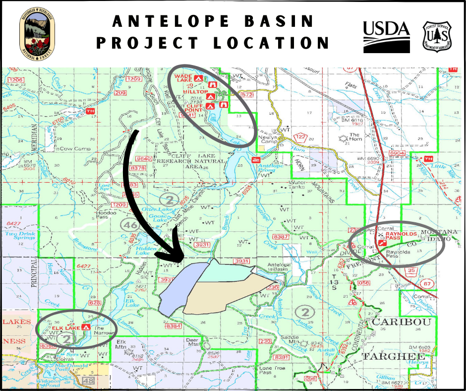
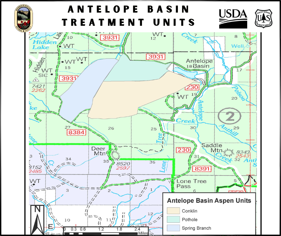
The Antelope Basin project area is located 53 miles south of Ennis in the Antelope Basin area, south and west of Conklin Lake. The area slated for treatment is approximately 350 acres in size. Smoke impacts should be minimal, as smoke is expected to dissipate quickly. However, smoke may be visible from US Highway 287 and MT Highway 87 in the Raynolds Pass area.
For updates or more information, contact the appropriate Ranger District offices below.
Dillon Ranger District (406) 683-3900
Madison Ranger District (406) 682-4253
April 30, 2024 Prescribed Fire Update 04 30 2024
Related Incident:
Publication Type: Announcement
Seeley Ranger District:
Firefighters will conduct up to 5 acres of pile burning today to reduce hazardous fuels from previous vegetation management operations. Pending conditions, the pile burns will take place around Camp Paxson and the Water District. Smoke may be visible from Highway 83.