
Battle Mountain Complex Zone II 07 25 2024
Related Incident: Battle Mountain Complex
Publication Type: News
Boneyard Fire merges into Monkey Creek Fire
UKIAH, Ore. – Overnight, the Boneyard Fire merged into the Monkey Creek Fire, now only referred to as the Monkey Creek Fire. Fire officials zoned the Battle Mountain Complex into Zones I and II, with ODF Incident Management Team 1 managing the west portion of the complex and ODF Incident Management Team 3 managing the east. Zones are used for effective management and resource allocation.
In Zone II, firefighters continued to see active fire behavior, slop overs and spot fires across the south of the fire overnight. Crews are focused on the southeast corner of the fire, where they are focused on fire suppression and constructing lines.
Along the south, structural taskforces built defensible space and provided direct suppression around homes and outbuildings. Overnight, the fire moved into the Pass Creek and Long Creek drainages and flats.
Along Highway 395 and the eastern edge of the fire, crews will continue firing operations down to the roadway, and the Oregon Department of Transportation will continue removing hazard trees along the road. Tree removal will continue over the coming days with heavy equipment using the roadway.
Firefighters may see a slight reprieve in temperatures, but still hot conditions, as winds come in from the west and southwest. Conditions will bring increased wind gusts.
The 4,485-acre North Fork Owens Fire is now 50% contained (the complex stands at 5% containment).
The Battle Mountain Complex consists of the North Fork Owens and Monkey Creek Fires – two of 17 fires in northeast Oregon that started in the late afternoon and evening of July 17, 2024. The Snake Fire merged with the Monkey Creek Fire on July 22, 2024, and the Boneyard Fire merged with Monkey Creek Fire on July 25, 2024.
Evacuations: Level 1 (Be Ready), Level 2 (Be Set) and Level 3 (Go Now) evacuations are in effect. For updated information, visit:
- For Umatilla County, follow facebook.com/UmatillaCountySheriff or sign up for Umatilla County Emergency Alert System at https://member.everbridge.net/index/2590041373147145.
- For Grant County, visit the RAPTOR arcgis site or sign up for alerts at: https://member.everbridge.net/index/825462649520134.
- For Morrow Couty, visit https://experience.arcgis.com/experience/
de78333b0d2544f7a320142174aa20ae
Settings - change map background and toggle additional layers
Filter - control incident types displayed on map.
Zoom to your location
Reset map zoom and position
Could not determine your location.
Show Legend
 Wildfire
 Prescribed Fire
 Burned Area
Response
Burned Area
Response Other
Other
Park Fire
Unit Information
Incident Contacts
Actualizacin del incendio Easy 25 de julio de 2024 07 25 2024
Related Incident: Easy Fire
Publication Type: News
Actualización del incendio Easy
25 de julio de 2024
Datos clave
Tamaño: 397 acres Fecha de inicio: 17 de julio dev2024 Ubicación: 17 millas al oeste de Mazama, WA
Contención: 0% Personal asignado: 95 Causa: Rayos
Recursos asignados: 2 cuadrillas 5 camiones de bomberos
SITUACIÓN ACTUAL: El miércoles, aumentaron los vientos con ráfagas de hasta 18-20 mph lo que resultó en que empeorara la actividad del fuego, y se quemaron árboles individuales dentro del área del incendio. El fuego arde entre madera grande y densa, muchos árboles muertos y vegetación de suelo en un terreno muy escarpado. Sigue desplazándose lentamente en los extremos del norte y sur mientras que se desplaza por la pendiente hacia la carretera estatal 20 (SR 20) North Cascades Highway.
Ayer, los helicópteros vertieron agua para frenar la propagación del fuego mientras que los equipos de tierra construían un cortafuego. El incendio está justo por encima de la carretera 20 y el desplazamiento de piedras, árboles caídos y el incendio activo cerca de la carretera obliga al cierre de la SR 20. El cierre está vigente para proteger al público de los peligros asociados con el incendio, así como de las actividades de extinción de incendios. Los equipos talan árboles muertos entre el extremo activo del incendio y la ruta estatal 20 para ayudar a limitar su propagación hacia la carretera. Los bomberos, junto con el Departamento de Transporte de Washington, están trabajando para remover los árboles caídos y los escombros de la carretera estatal 20 y cada día evalúan las condiciones de las carreteras y la actividad del fuego.
ACTIVIDADES DE HOY: Los bomberos continúan talando árboles debajo y al lado de la carretera 20 y están trabajando para reforzar los cortafuegos indirectos en el incendio Easy. Las cuadrillas también retirarán árboles caídos y escombros a lo largo de la carretera 20 con la ayuda del Departamento de Transporte de Washington. Además, seguirán utilizando helicópteros para vertir agua si lo permiten las condiciones climáticas. Se está pensando nuevamente en envolver la Mebee Lookout Tower debido al aumento en la actividad del fuego en el extremo norte del incendio. Las cuadrillas están explorando para establecer helipuntos y así tener una zona de aterrizaje para que los helicópteros dejen provisiones para las operaciones de protección de estructuras en Mebee Lookout Tower.
CLIMA: Mañana continuarán bajando las temperaturas con máximas en los 70 grados. Mañana, una capa marina entrante se desplazará sobre el incendio Easy, lo que resultará en unas cuantas centésimas de pulgada de lluvia y mas humedad. El aire húmedo más frío podría causar neblina y aumentar los vientos, lo que afectaría los recursos de aviación.
EVACUACIONES: No existen órdenes de evacuación para el incendio Easy. Cualquiera que utilice la zona para recrearse debe estar atento a su entorno y permanecer fuera de las áreas cerradas. Visite https://t.ly/QoH9w para tener más información sobre los niveles de evacuación.
CIERRES: La ruta estatal 20 se encuentra cerrada en ambas direcciones entre Granite Creek (MP 148) y Easy Pass Trailhead (MP 157).
El Bosque Nacional Okanogan-Wenatchee tiene órdenes de cierre en los senderos dentro del área afectada por el incendio: https://bit.ly/EasyFireClosures. Este cierre incluye una parte del sendero Pacific Crest Trail. Las fogatas están prohibidas. Hay una restricción temporal de vuelo (TFR, en inglés) sobre el área del incendio: https://tfr.faa.gov/save_pages/detail_4_6779.html. La actividad de drones no autorizados está prohibida por la TFR.
InciWeb: https://inciweb.wildfire.gov/incident-information/waowf-easy-fire
Facebook: https://www.facebook.com/profile.php?id=61560760893080
Línea de información sobre el incendio: 541-861-5808, de 8 AM a 8 PM
Correo electrónico: 2024.easy@firenet.gov
Actualizacin diaria del incendio Pioneer 25 de julio de 2024 07 25 2024
Related Incident:
Publication Type: News
Actualización diaria del incendio Pioneer
25 de Julio de 2024
Tamaño: 31,584 acres
Fecha de inicio: 8 de junio de 2024
Ubicación: 31 millas al NO de Chelan, WA
Contención: 14%
Personal: 729
Causa: De origen humano, a ser determinada
Recursos asignados: 9 cuadrillas, 4 helicópteros, 25 camiones de bomberos, 28 tanques de agua, 12 maquinarias pesadas
SITUACIÓN ACTUAL: Ayer aumentó la actividad de fuego en el desague de Flick Creek, ya que saltó el arroyo por encima de la línea de control que se había construído. El incendio continúa en una trayectoria noroeste hacia Fourmile Creek y en dirección a Stehekin. Como precaución, a partir de las 8 a.m. del jueves 25 de julio el departamento de Gestión de emergencias del condado de Chelan emitió un aviso de evacuación de Nivel 2 para la comunidad de Stehekin, desde Hazard Creek y todo el valle de Stehekin, incluido el desembarco de Stehekin y hacia el oeste hasta High Bridge. Todo visitantes relacionado con el turismo y todos los campistas y excursionistas deben salir de Stehekin el 25 de julio. Hay más información disponible, incluidos los horarios de los barcos, del departamento de Gestión de emergencias del condado de Chelan en https://t.ly/QoH9w.
Han sido exitosos los esfuerzos de las cuadrillas en proteger casas y dependencias a lo largo de la orilla del lago, al quemar la vegetación alrededor de las estructuras y la infraestructura pública a medida que el fuego se desplaza hacia el norte. Helicópteros y aviones de ala fija siguieron vertiendo agua para frenar la propagación del fuego. En Stehekin, los bomberos trabajaron en conjunto con el grupo estatal de protección movilizado de estructuras para minimizar el riesgo de incendio alrededor de casas y propiedades privadas. En el extremo sur, el incendio sigue sin crecer en el desague de Lone Fir, ya que no ha crecido por varios días. Las líneas de control indirecto entre el extremo sur del incendio y Manson están listas para usarse por si es necesario.
Anoche el equipo de gestión de incidentes patrocinó una reunión comunitaria en Manson para brindar actualizaciones sobre el incendio. Se puede ver una grabación de la reunión en la página de Facebook sobre información del incendio Pioneer.
ACTIVIDADES DE HOY: Los bomberos seguirán protegiendo las casas a lo largo de la orilla del lago y están preparados para quemar estratégicamente la vegetación entre las líneas de control y el borde del incendio para frenar la propagación hacia la comunidad de Stehekin. Las aeronaves también seguirán vertiendo agua dentro de los desagues de Flick Creek y Fourmile Creek. Continuará el trabajo para minimizar los riesgos de fuego alrededor de las casas en Stehekin y los bomberos instalarán un sistema de mangueras y rociadores y lo pondrán a prueba para garantizar que funcione correctamente. Las cuadrillas continuarán vigilando el extremo sur en el desague de Lone Fir.
CLIMA: Hoy se esperan fuertes vientos del noroeste de 10 a 20 mph con ráfagas de 25 a 30 mph, y su velocidad irá bajando hasta mañana por la mañana. Se esperan condiciones más frescas y húmedas, con temperaturas máximas en los 70 grados.
EVACUACIONES: Los niveles 1, 2 y 3 de evacuación alrededor del incendio Pioneer no han cambiado. Visite https://t.ly/QoH9w para tener más información.
CIERRE DEL BOSQUE: Cierres vigentes del Parque nacional North Cascades: https://www.nps.gov/noca/index.htm
El Bosque Nacional Okanogan-Wenatchee ha emitido una orden de cierre sobre gran parte del área afectada por el incendio: https://bit.ly/PioneerClosure. Las fogatas están prohibidas. Hay una restricción temporal de vuelo (TFR, en inglés) sobre el área del incendio: https://tfr.faa.gov/save_pages/detail_4_6779.html. La actividad de drones no autorizados está prohibida por la TFR.
Facebook: https://www.facebook.com/profile.php?id=61560760893080
Línea de información sobre el incendio: 541-861-5808, de 8 AM a 8 PM
Correo electrónico: 2024.pioneer@firenet.gov
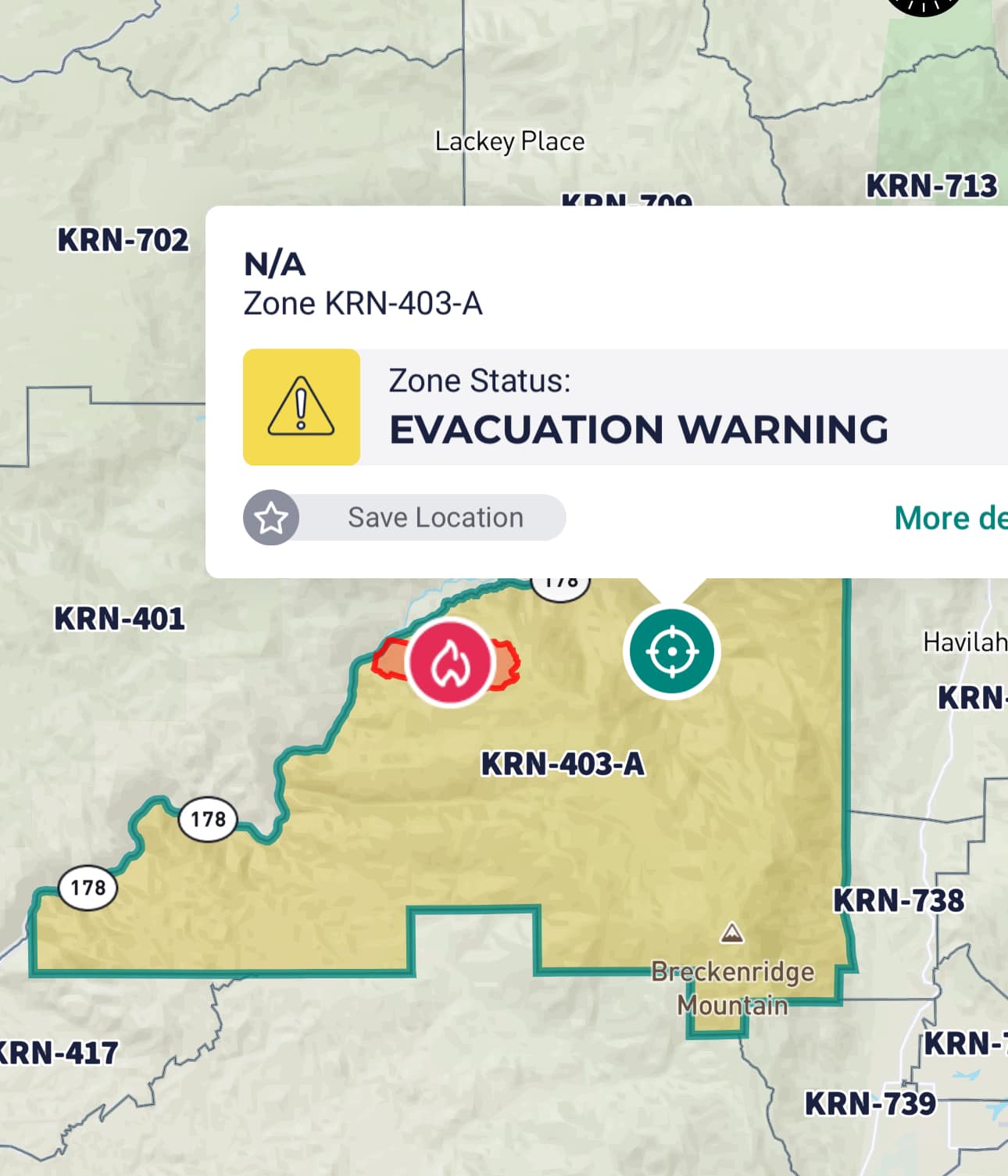
Borel Fire Kern County Evacuation Warning 07 25 2024
Related Incident: 2024 SQF Lightning
Publication Type: Announcement
Kern County Fire Department issued an evacuation warning for zone KRN-403-A (the Breckenridge area) as a result of the Borel Fire that started on Wednesday, July 24.
Be aware that travel is OPEN to the public and unaffected by the evacuation WARNING in the following areas:
Caliente Bodfish Road -- OPEN
Lion's Trail -- OPEN
Access to Hooper Hill -- OPEN

Oakridge Lightning Fires 2024 Daily Update Thursday 07 25 2024
Related Incident: Willamette Complex Fires - South
Publication Type: News
Fire Update – Oakridge Lightning Fires
Chalk, Coffeepot, McKinley, Moss Mountain, Tire Mountain, 208, and 217 Fires
Thursday, July 25, 2024 – 9:00 a.m.
Rocky Mountain Complex Incident Management Team 1
Dan Dallas, Incident Commander
Information Phone: (541) 208-1742
Email:2024.mossmountain@firenet.gov
Information Staffing Hours: 8 a.m. to 8 p.m.
Current Situation: Firefighters continue suppression efforts on the Chalk, Coffeepot, Moss Mountain, and 208 fires. The McKinley, Tire Mountain, and 217 fires are lined with little to no spread. Infrared flights have provided more accurate fire perimeters, allowing fire management staff to better assess the strategies needed to suppress the seven fires collectively known as the Oakridge Lightning Fires. Northwestern winds and warm temperatures will continue to impact suppression efforts in steep and rugged terrain over the next several days. The total acreage of the seven fires is 4,425 acres with more than 500 personnel assigned.
Fire activity across the nation, and especially in the state of Oregon, are putting extreme demand on all available firefighting resources. Strategies with the highest probability of success will be prioritized in protecting highly valued resources, while keeping public and firefighter safety as the top objective.
On large, complex fires, supervisors divide the fire perimeter into Divisions to provide for better management and safer operations. These daily updates will describe the fire’s activities and suppression actions within these Divisions (labeled on the accompanying fire maps). Note that Division letters don’t always run sequentially so that new Divisions may be added if the fire grows.
The following fire information is provided in order of suppression priority.
Chalk Fire (2,701 acres, 0% contained) – Crews continue to build and secure line to provide additional options for future strategic containment operations.
Division AA: The fire is backing down toward the 1920 Road and existing trails where it is expected to hold. Firefighters are laying fire hose and securing fireline to support containment efforts.
Division KK: Line is being constructed and secured to tie in with existing roads and trails. Firefighters are making good progress in securing the southeast and southwest areas of the fire.
Division TT: The 2021 Gales Fire footprint will assist firefighters in securing the north section of the Chalk Fire. In addition to hand crews, heavy equipment is being used to build and strengthen this line.
Coffeepot Fire (1,312 acres, 0% contained) – The Coffeepot Fire increased in size yesterday due to receptive fine and heavy fuels in terrain that aligned with northwestern winds. Crews in this area are focused on building and strengthening line.
Division PP: Steep, rugged terrain aligned with wind direction last night, allowing the Coffeepot Fire to grow and reach the 2120 Road, where it is currently being held. Crews will continue to prep and secure line today, moving east toward Division WW.
Division RR: Firefighters will work along the 2307 Road and continue east to tie into Division WW.
Division WW: Heavy equipment is being used in this division from 2307 Road toward 23 Road, building and securing line toward Division PP to provide management with future options for strategic operations.
Moss Mountain Fire (190 acres, 0% contained) – The Moss Mountain Fire, in Division WW, is very difficult to access due to steep terrain and rugged road conditions. Fire growth was minimal in this area yesterday, where crews are assessing options for the highest probability for success.
208 Fire (138 acres, 0% contained) – Division YY: The 208 Fire is located entirely within the Diamond Peak Wilderness area, where there has been little growth. Air resources are being requested to provide better perimeter mapping.
217 Fire (37 acres, 0% contained) – Division YY: This fire is also within Diamond Peak Wilderness and is threatening to spread outside the Wilderness boundary on its north flank. Smokejumpers have been in this area for the past several days as they mop up and assess options for future actions.
Tire Mountain Fire (20 acres) – Division TT: Fireline completed, minimal activity yesterday as the fire backed toward containment lines.
McKinley Fire (27 acres) – Division AA: Fireline completed, crews continue to mop up and secure fireline as they work toward full containment.
Weather and Fire Behavior:
Weather conditions will remain consistently sunny over the next several days with daytime temperatures in 70s to 80s and relative humidity in the 35-45% range. Clouds moved in from the coast last night, which provided cooler morning temperatures and relative humidities in the 80-100% range. Cloud cover is expected to dissipate this afternoon, which will allow sun to align with the fire on certain aspects. Increased fire activity is expected this afternoon.
Evacuations:
For evacuation information please visit: https://www.LaneCountyOR.gov/2024wildfires
To sign up for evacuation alerts please visit: https://www.LaneAlerts.org
Closures and Fire Restrictions:
Area, road, trail, and recreation site closures are in place on the Willamette National Forest in the vicinity of many active fires. Temporary road barricades are in use to restrict traffic in the areas near High Prairie and Chalk Mountain.
For specific closure information follow this link:
https://www.fs.usda.gov/detail/willamette/alerts-notices/?cid=fseprd552029
Fire restrictions on the Willamette National Forest may be found at this link: https://www.fs.usda.gov/alerts/willamette/alerts-notices/?aid=81487
Wildfires are a no-fly zone for unauthorized aircraft, including drones. If you fly, we can’t. For more information, visit http://knowbeforeyoufly.org.
Fire Statistics
Total Personnel: More than 500
Location: N & S of Oakridge, OR
Reported: Various
Cause: Lightning
For More Information
Information Phone: (541) 208-1742
Email: 2024.mossmountain@firenet.gov
InciWeb: https://inciweb.wildfire.gov/incident-information/orwif-oakridge-lightning-fires-2024
Facebook: https://www.facebook.com/OakridgeLightningFires2024/
Falls and Telephone Fires Update 07 25 2024
Related Incident: Falls FireTelephone Fire
Publication Type: News
Falls and Telephone Fires Update for July 25, 2024
Falls Fire Quick Facts:
Size: 140,422 Start Date: July 10, 2024 Location: 13 Miles NW of Burns, OR
Containment: 50% Total Personnel: 1,628 Cause: Human-caused, under investigation
Structures Triaged: Residences: 347; Commercial: 104; Outbuildings: 605
Resources Assigned: 49 hand crews, 93 engines, 23 bulldozers, 31 water tenders
Aerial resources available to the fire: two helicopters, and single-engine air tankers (SEATS)
Telephone Fire Quick Facts:
Size: 9,000 Start Date: July 22, 2024 Location: 12 miles NE of Burns, OR
Containment: 0% Total Personnel: Staffed by Falls Fire personnel Cause: Lightning/Natural
Despite high, multi-directional, outflow winds from thunderstorms, control lines on Falls and Telephone fire held firm yesterday. Oregon State Fire Marshall (OSFM) Task Forces and wildland firefighters responded to multiple new starts likely resulting from lightning strikes in the early afternoon. Oregon State Fire Marshal crews were in position to protect structures on both the east and west sides of the highway – including those to the North of the Telephone Fire. Additional crews staffed the structures along the southern edge of the Telephone Fire.
The coordinated efforts of structural and wildland resources have resulted in reducing the risk to structures, thanks to extensive prep work, the reinforcement of control lines and widespread mop up efforts. OSFM will begin to draw down resources accordingly, returning them to their home agencies and increasing availability for other Oregon fires. As a result, three OSFM task forces will be demobilized today. These crews are from Douglas, Tillamook, Clackamas, and Washington Counties. Five OSFM structure groups will remain on the fire, a combination of California and Washington Task Forces. Local resources also remain available to provide structural response should the need arise.
Northwest Incident Management Team will transition to Alaska Team 1 assuming command of both fires at 6:00 AM tomorrow.
Falls Fire: Yesterday, OSFM and wildland crews protected numerous structures along County Road 63, as well as the ranches near Blackhorse Butte and Greenspring Draw. Fortunately, surface prep had previously been completed on these structures by OSFM crews as part of a contingency plan for the Falls Fire. Containment lines held along southern portions of the fire perimeter and as well as much of the eastern and western flanks of the fire. The fire remained active in the northern perimeter of the fire as crews continued to complete construction of both direct and indirect control line.
Today, crews in the northwest corner of the fire will also continue to hold and mop-up below the western slopes of Burnt Mountain along FSR 4785 near Coral Creek south and east to FSR 47 near the junction with FSR 3150. Crews will work to connect fireline back into FSR 3150 in the northeast corner of the fire. Work will also continue further east on FSR 3150, preparing it to use as a control line, and for conducting tactical burnouts.
The northeast corner of the fire remains active. Firefighters will continue to hold and mop up areas adjacent to the FSR 31 south of Myrtle Park Meadows, and work on tying the fire back into the FSR 31. Structural and wildland crews are coordinating to protect structures and mitigate risk to the Gold Hill and Silvies Valley areas.
Patrol and mop-up operations will continue along the south half of the fire perimeter – the area spanning from the southwest perimeter of the fire to near the upper northwest perimeter. Further north, away from the fire perimeter, construction will continue on a planned secondary contingency line along FSR 37 just west of Hwy 395 in the Fisk Gulch area. This secondary contingency line is part of an alternate plan and will run east to west using portions of FSR 37 and FSR 31.
Telephone Fire: Yesterday, crews continued to construct and hold control lines around the fire, having good success despite the challenges of thunderstorms and high winds. Control lines have been established on the west flank, along FSR 2820, to the north, along FSR 480, and east along FSR 28. Firefighters caught a number of spots north of FSR 480. Firefighters also scouted for areas to construct control lines to the south.
Today, crews will continue to secure and hold established control lines along the northern, southern, and eastern perimeters, and work to establish control line on the southern end of the fire. Crews will also continue to mop-up spots north of FSR 480. Aerial resources will be available to help with suppression operations. Structural crews will be completing reassessments on previously prepped structures along the fire’s southern edge.
New Fire Activity: At least eight new fire starts have been located within the area that the Incident Management Team has been delegated authority to conduct initial attack and take suppression actions. Crews responded quickly and most of the new starts have been kept small. Wildland and OSFM resources will be working to protect values are risk and establish control lines around all of the new starts.
The largest of the new fires is the Whiskey Mountain Fire, which is located 2 ½ miles southwest of Whiskey Mountain and is approximately 1,300 acres. The Sand Fire is approximately 540 acres and located on the north side of the Falls Fire near Sand Mountain. Structural resources will complete full prep in the area impacted by the new fire starts north of Falls Fire. This includes areas from Officer’s Cabin, working east towards Lewis Creek Ranch and spanning along the northern edge of the fire to Highway 395, as well as down into Silvies Valley where the Falls Fire remains active. Resources will also be completing full prep on buildings along the 63 road, ensuring structural protection in the Sand Mountain area.
Southeast of the Telephone Fire OSFM brought night shift resources to the line early to assist local resources with initial attack on a new start off Cow Creek. Fortunately, resources were quickly able to get this fire under control and the threat to structures in the immediate area has been mitigated.
Weather: Cooler today with temperatures in the 80s. Skies will generally be clear. Diurnally-driven northwesterly winds will become westerly and breezier in the afternoon before returning to northeasterly. There is a 5 percent chance of thunder storms.
Evacuations: Evacuations remain in place in both Grant and Harney Counties due to the Falls and Telephone Fires. For the most accurate evacuation information, please visit the Harney County Sheriff’s evacuation map here: https://tinyurl.com/3zst4sjy, or the Grant County Emergency Management Facebook page at: https://www.facebook.com/profile.php?id=100068819321423.
Closures: Due to active wildfires compounded by extremely unfavorable weather conditions, limited firefighting resources and County Resources, Malheur National Forest officials have temporarily closed lands within the Malheur National Forest.
Investigation: U.S. Forest Service fire investigators are seeking the public’s assistance with any tips or information pertinent to the start of the Falls Fire on the Malheur National Forest. Please submit any information that could assist fire investigation efforts to SM.FS.R6TipHotLine@usda.gov.
Facebook: https://www.facebook.com/p/Falls-Fire-2024-61562126623985/
Falls Fire InciWeb: https://inciweb.wildfire.gov/incident-information/ormaf-falls-fire
Telephone Fire InciWeb: https://inciweb.wildfire.gov/incident-information/ormaf-telephone-fire
Fire Information Line: 541-208-4370, staffed 8 a.m. to 8 p.m.
Email: 2024.Falls@firenet.gov
Harney County non-emergency evacuation questions: 541-589-5579
Air quality questions: 541-573-2271
Smoke Outlooks: https://outlooks.airfire.org/outlook
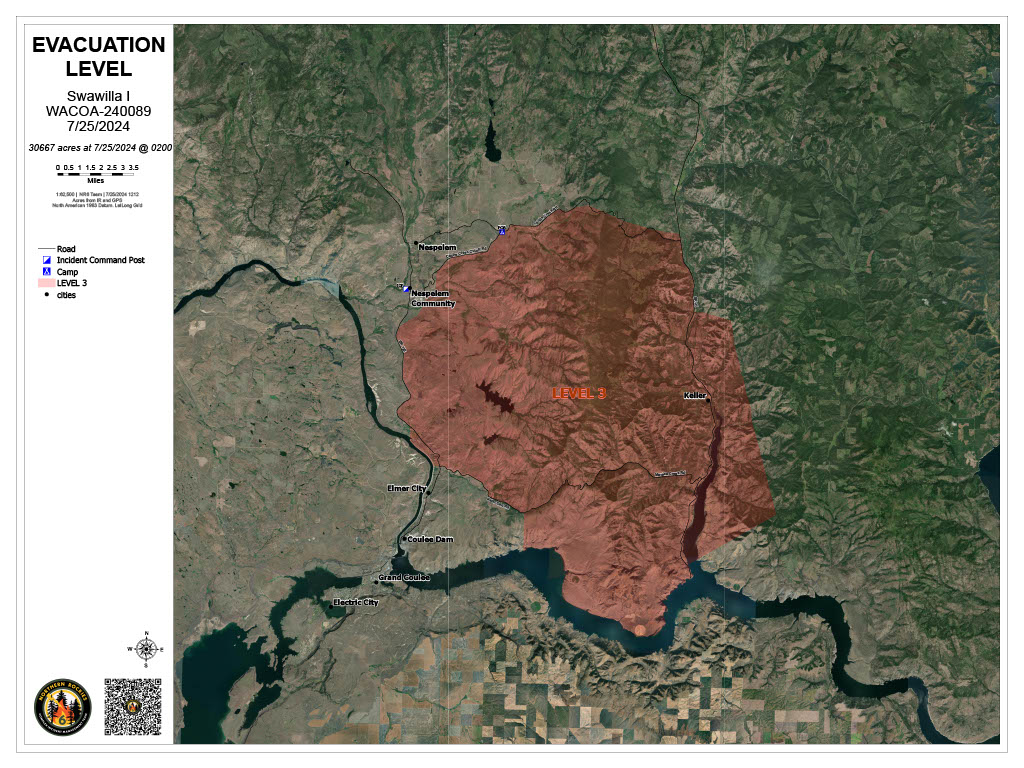
Level 3 GO Evacuations for all Swawilla wildfire communities 07 25 2024
Related Incident: Swawilla Fire
Publication Type: Announcement
Update for Swawilla Fires:
Evacuation Level 3 (GO) put in place for:
Everything South of Cache Creek Road to Joe Moses Road, west to Highway 155 and east to State Highway 21 went to a Level 3 Wednesday, July 24 at 7:30 PM. This includes a change of the Town of Keller and surrounding community from a Level 2 to a Level 3. This is a general description and a more detailed map will be posted as soon as it is available.
The area of Buffalo Lake and Lake McGinnis remains in a Level 3 (GO).
Settings - change map background and toggle additional layers
Filter - control incident types displayed on map.
Zoom to your location
Reset map zoom and position
Could not determine your location.
Show Legend
- Wildfire
- Prescribed Fire
- Burned Area
Response
- Other
Retreat
Unit Information
Incident Contacts
Pioneer Fire Update 07 25 2024
Related Incident:
Publication Type: News
Pioneer Fire Update for July 25, 2024
Incident Commander Lonnie Click
Complex Incident Management Team Northwest 3
(541) 861-5808, staffed 8 a.m. to 8 p.m. 2024.pioneer@firenet.gov
Quick Facts
Size: 31,584 acres
Start Date: June 8, 2024
Location: 31 miles NW of Chelan, WA
Containment: 14%
Personnel: 729
Cause: Human-caused, under investigation
Resources Assigned: 9 crews, 4 helicopters, 25 engines, 28 water tenders, 12 heavy equipment
CURRENT SITUATION: Yesterday fire activity increased in the Flick Creek drainage, crossing the creek above the constructed a check line. The fire continues on a northwest trajectory towards Fourmile Creek and in the direction of Stehekin. As a precautionary measure, Chelan County Emergency Management issued a Level 2 evacuation notice for the community of Stehekin, from Hazard Creek through the Stehekin Valley, including the Stehekin landing and west to High Bridge effective 8 a.m. Thursday, July 25. All tourism-related visitors and all campers and hikers are required to leave Stehekin on July 25. More information, including boat schedules, is available from Chelan County Emergency Management at https://t.ly/QoH9w.
Crews have been successful protecting homes and outbuildings along the lake shore, burning out vegetation around structures and public infrastructure as the fire has progressed northward. Helicopters and fixed wing aircraft continued aerial water drops to slow fire spread. In Stehekin, firefighters worked in collaboration with the state mobilized structure protection group to reduce fire risk around homes and private property. The south end of the fire continues to hold in the Lone Fir drainage where there has been no movement for several days. Indirect control lines between the southern edge of the fire and Manson are prepared and ready to be used if needed.
The incident management team hosted a community meeting in Manson last night to provide updates on the fire. A recording of the meeting can be viewed on the Pioneer Fire Information Facebook page.
TODAY’S ACTIVITIES: Firefighters will continue protecting homes along the lake shore and are prepared to strategically burn out vegetation between control lines and the fire’s edge to slow spread towards the community of Stehekin. Aircraft will also continue to perform water bucket drops within the Flick Creek and Fourmile Creek drainages. Work to reduce fire risks around homes in Stehekin will continue and firefighters will be laying a hose and sprinklers system and testing to ensure it is working properly. Crews will continue monitoring the southern edge of the fire in the Lone Fir drainage.
WEATHER: Strong northwest winds are expected today, 10-20 mph with gusts of 25 to 30 mph, slowing into tomorrow morning. Cooler, moister, conditions are expected, with high temperatures in the 70s.
EVACUATIONS: Level 1, 2 and 3 evacuation levels remain in effect around the Pioneer Fire. Please visit https://t.ly/QoH9w for more information.
FOREST CLOSURE: Current closures for the North Cascades National Park: https://www.nps.gov/noca/index.htm
The Okanogan-Wenatchee National Forest has a closure order in place for much of the fire area: https://bit.ly/PioneerClosure. Campfires are prohibited. There is a Temporary Flight Restriction (TFR) in place over the fire: https://tfr.faa.gov/save_pages/detail_4_6779.html. Unauthorized drone activity is prohibited under the TFR.
Facebook: https://www.facebook.com/profile.php?id=61560760893080
Fire Information Line: 541-861-5808, 8 AM to 8 PM
Email: 2024.pioneer@firenet.gov