
Durkee and Cow Valley Fires Daily Update 07 25 2024
Related Incident: Durkee FireCow Valley Fire
Publication Type: News
Durkee, Cow Valley, and Bonita Fires Update for Thursday, July 25, 2024
541-208-4371, staffed 7AM to 7PM PDT
DURKEE FIRE: Start date: July 17, 2024 | Location: 5 miles southwest of Durkee, OR | Personnel: 514 | OSFM Task Forces: 4 | Fire size: 268,492 acres | Cause: Lightning | Containment: 0%
Today, moderate fire behavior is expected.
Moderate post-frontal weather conditions are forecasted (including a slight drop in temperature, higher humidity, calmer winds and a low probability of thunderstorms). Firefighters will seize the opportunity to employ direct strategy with handline, heavy equipment and other means to continue their full suppression efforts.
Today’s fire operation priorities include containment in the Bridgeport, Shirttail Creek Road and Rye Valley areas. Where firefighters were successful holding the fire edge in the I-84 corridor, mop up around structures is also a focus.
Yesterday, gusty and erratic winds, lightning and flash flood warnings were present. At higher elevations, red flag outflow winds brought on by back-to-back thunderstorms initially formed a southeast front with 45 mph gusts. Observed near Unity, winds increased to 66 mph. 55 mph gusts were seen throughout the night.
Although yesterday’s weather conditions caused spot fires (also known as a slop-over) in many areas, firefighters saw a lot of successes catching them. During the height of extreme fire behavior conditions and heavy gusts, one report noted a 30-acre slop-over across HWY 30 at 3:30pm. The Oregon State Fire Marshal and NW Team 6 operations acted in partnership with railroad operations to contain fire that threatened three structures.
Aerial resources will be coordinated and prioritized between the Badlands Complex, Durkee Fire and Vale BLM going forward due to state-wide fires and resource availability.
Areas in the Durkee fire footprint experienced up to ½ an inch of precipitation and reports of debris flows are expected. However, the north end of the Durkee fire only saw 2/10 of an inch of rain and fire behavior is still expected to be active in days to come, across the Durkee fire footprint.
Be aware, hazardous air warnings are in place across the Durkee Fire footprint. For current smoke information, visit airnow.gov
The Malheur County Sheriff’s Office and the Baker County Sheriff’s Office have issued evacuations for multiple areas. Residents in Level 3 Evacuations “GO NOW”, should leave immediately. Residents should not return to their property until evacuation levels have been removed. Carry enough supplies to support you and your family for multiple days. A real time map of fire evacuations can be found at the State of Oregon Fire Dashboard.
Weather and fire behavior could impact transportation, power transmission, cell service and other utilities. Monitor these resources for additional information.
- Oregon Department of Transportation - TripCheck.com
- Idaho Power - IdahoPower.com
- American Red Cross of Eastern Oregon and Idaho - https://www.redcross.org/local/idaho.html
The Durkee Fire is located west of Interstate 84 (I-84). The Thompson Fire, a convergence of lightning fires that started near Thompson Creek on July 22, is located east of I-84. Both have grown rapidly with the persistent high temperatures, strong winds, and extremely dry fuels. Although moderate fire behavior and weather conditions are expected today, be aware of the possibility of fire growth.
BURN BAN: A burn ban is currently in effect for all of Malheur County, including all BLM lands. For more information, visit https://www.malheurco.org/category/public-notices/.
TEMPORARY FLIGHT RESTRICTION: There is a temporary flight restriction over the Durkee Fire, please remember, if you fly we can’t! If a drone or other aircraft enters the air space, all firefighting aviation equipment will be grounded.
--
COW VALLEY FIRE: Start date: July 11, 2024 | Location: 9 miles east of Ironside, OR | Personnel: 0 | Fire size: 133,490 acres | Cause: Human caused |Containment: 91%
BONITA FIRE: Start date: July 11, 2024 | Location: 9 miles south east of Ironside, OR | Personnel: 0 | Fire size: 2,727 acres | Cause: Human caused |Containment: 90%
--
Durkee and Cow Valley Facebook Page
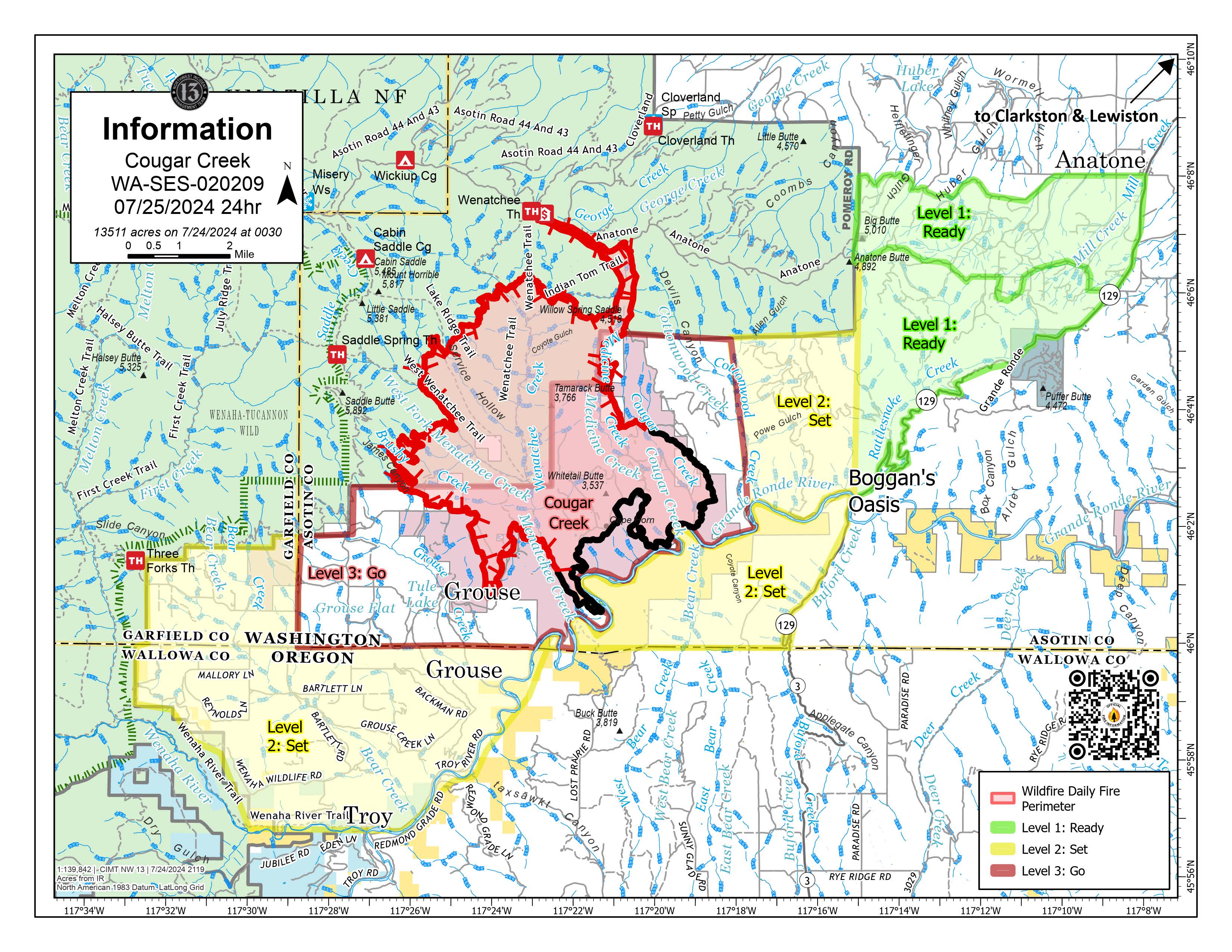
Cougar Creek Fire Update 07 25 2024
Related Incident: Cougar Creek Fire
Publication Type: News
Cougar Creek Fire Update for Thursday July 25, 2024
KEY MESSAGES:
Incident priorities remain protection of community, rural residences, grazing allotments, and private timber. Yesterday morning, crews successfully added line on the southern edge of the fire, bordering the Grande Ronde River, resulting in an increase in containment. In the evening, lightning storms struck over the fire perimeter and surrounding communities. Crews responded throughout the night to new starts as the area was assessed. Burning conditions will remain critical as fuels have not had enough prolonged moisture to slow fire growth.
CURRENT STATUS:
Crews are working to tie the fireline from the 40 Road going west, south of the 4039 Road to Three Forks Trailhead. Crews continue to support line construction on the eastern flank of the fire, from Wenatchee Guard Station down to Hansen Ridge in advance of the west winds. Protection efforts in the community of Grouse Flats continue around structures.
FIRE BEHAVIOR AND WEATHER:
Fire behavior continues to be active as topography acts as the main component of fire growth. The fire area will have westerly winds developing over the next few days. Temperatures will be in the high 70s and low 80s, with higher relative humidity at 20%.
EVACUATIONS AND CLOSURES:
Forest closure descriptions and maps are available online on the Umatilla National Forest Closure page. In Washington, evacuation notices are posted on the Asotin County Sheriff webpage and Asotin County Emergency Management Facebook. Grande Ronde Road is closed from Troy, Oregon to Highway 129 junction in Washington. In Oregon, a level 2 evacuation is in effect for Wallowa County, including all of Grouse Flat from Bear Creek Rd north to the State boundary and the Garfield County line to Grande Ronde River.
Fire Reaches Control Lines 07 25 2024
Related Incident: Mestenas Canyon Fire
Publication Type: News
The Mestenas Canyon Fire is now fully surrounded by control lines. Crews on Wednesday cut handline on the fire’s northwest edge, increasing containment on the now 837-acre blaze to 65 percent.
The fire’s north end remains the only uncontained area, however the control line is Forest Road 312N, which has been blacklined.
“We’re keeping an eye on this area because upslope winds out of Mestenas Canyon could create a slop-over,” said Jicarilla District Ranger Jim Eaton, referring to when a fire crosses a control line. “We’ll call it fully contained when we are confident the fire won’t move.”
The lightning-caused Mestenas Canyon Fire was first reported July 11. It is in the canyon of the same name, about 14 miles southwest of Dulce, N.M., and two miles north of Highway 64, where smoke may cause limited visibility to drivers.
The public can keep updated on the fire by visiting InciWeb or calling a public information officer at 505-216-6793.
Miller Peak Daily Update July 25 2024 07 25 2024
Related Incident:
Publication Type: News
KEY MESSAGE
Red Flag Warning issued for the Missoula area starting at noon 07/25/24 Continues on until 2100 on 07/25/2024.
CURRENT STATUS
Following strong winds over the fire area last night, crews will focus on assessing the fire and patrolling for spots or flair ups outside the fire perimeter. An infrared equipped UAS (drone) will be utilized to aid in the search for any new areas of heat. Presently there is line around the perimeter of the fire that is secured with hand dug lines, machinery and cold burned areas. Divisions are well prepared to prevent breach of the line, focusing on the northeastern side of the fire. In the southeastern section of the fire, crews have halted progression of the fire with special focus on the values at risk and connecting lines to the Northeast. The I-90 corridor remains a vital value and is the priority for the heavy equipment and air attack on the east side.
WEATHER AND FIRE BEHAVIOR
Hot and dry conditions combined with gusty westerly winds and afternoon storms create critical fire weather conditions. Winds are forecasted to increase over the fire area over the next 24 to 36 hours. As a result of these conditions the fire location is under a Red Flag Warning by the National Weather Service starting at noon on Wednesday. There were record breaking wind speeds recorded for the Missoula area. Mount Sentinel was showing gusts of 109 mph. The fire area received up to ¼ inch of rain.
CLOSURES
Lower Miller Creek Road is closed from debris due to the storm. A temporary flight restriction is in effect over the fire area. An area and road closure around the fire is in effect due to hazardous conditions resulting from fire activity. Stage II fire restrictions are in effect in the area. Specific closure information and maps are posted on InciWeb at https://inciweb.wildfire.gov/incident-information/mtlnf-miller-peak-fire and https://www.fs.usda.gov/alerts/lolo/alerts-notices as they are implemented.
Homestead Complex Fire Update07 25 2024
Related Incident:
Publication Type: News
Full Suppression Efforts Continue On All Fires in the Homestead Complex
The seven confirmed fires in the Homestead Complex now total a combined 1,044 acres based on aerial infrared mapping. Suppression tactics are being prioritized by threat to property, infrastructure, industry and areas with the highest probability of success. Approximately 235 personnel are engaged including hand crews, engines, water tenders, dozers, feller bunchers and skidgeons.
Handcrews, engines, and heavy equipment continue building direct and indirect containment lines on the Horse Heaven Creek Fire (288 acres), the most active fire in the complex.
Crews and heavy equipment operators on the No Man Fire (317 acres) north of Chilcoot Mountain are using roads in the area to construct containment line around the fire. The steep, rugged terrain means it is unlikely that firefighters will be working on the ground close to the fire’s edge. Great Basin Team 5 continues to work with cooperators west of the fire to coordinate the construction of indirect control lines.
A hotshot crew is constructing direct fireline on the Salmon 33 (132 acres). Firefighters assigned to the Reynolds Butte Fire (104 acres) are building direct containment lines in areas that have been identified as having the greatest likelihood for success.
A handcrew, water tender, and skidgen are holding and improving existing control lines and will begin removing hoselay on the Lost Bucket Fire (35 acres). The Fuller Lake Fire (54 acres) and Bullpup Fire (114 acres) are currently unstaffed. Firefighters are assessing opportunities to develop direct and indirect control lines when resources are available.
Weather today is expected to be slightly cooler with light wind. Smoke and high-level cloud cover should reduce solar heating today, which may moderate fire activity. Information about smoke impacts is available at https://outlooks.airfire.org/outlook/d393fd74.
Area fire restrictions and danger ratings are as follows: Fire Danger Rating: High. Industrial Fire Precaution Levels (IFPLs): 2. Public Use Fire Restrictions (PURs): 2.
CLOSURES: Umpqua National Forest has issued two closures across the forest in response to fire activity to protect public and wildland firefighter safety. Emergency Fire Closure ORDER NO. 06-15-24-03 and Emergency Fire Closure ORDER NO. 06-15-02-24-01 which impact all of the Cottage Grove Ranger District, most of the Diamond Lake Ranger District, and parts of the Tiller and North Umpqua Ranger Districts. The closure orders can be found here: https://www.fs.usda.gov/alerts/umpqua/alerts-notices.
Hill Fire Morning Update 07 25 2024
Related Incident: Hill Fire
Publication Type: News
HILL FIRE INCIDENT UPDATE
Date: July 25 2024
Fire Information: 530-414-9056
Hours: 08:00 AM to 8:00 PM
Email:2024.Hill@firenet.gov
Incident Website:
https://inciweb.wildfire.gov/incident-information/casrf-hill-fire
https://www.fire.ca.gov/incidents/2024/7/16/hill-fire
Location: Humboldt County, CA
Size: 7098 acres
Cause: Under Investigation
Start Date: Monday July 15, 2023, at 5:40 PM
Percent contained: 14%
Personnel: 1920
CURRENT SITUATION:
Hot and dry weather persisted yesterday and tested containment lines. All established lines held, and firefighters continued to work around the clock to implement a full suppression strategy.
Suppression and mop up efforts from firefighters have been effective along the north, west, and south of the fire. To the east of the fire, resources have focused on the east side of Sugarloaf Mountain, addressing the spot fire that occurred two days ago. Direct and indirect dozer lines have been established and tied into Forest Road 5N14, as this area has become the top priority for crews to contain. There was no movement on the spot fire last night.
Crews will continue to work day and night and utilize aircraft to ensure the fire remains within its current containment lines. Contingency lines will be completed to the south and along the Hennessy Ridge in the east. A structure defense plan is in place, and resources are in the communities assessing structures.
WEATHER:
Conditions will begin to ease today. However, battling winds will persist, fighting from the southeast to northeast. Wind will generally be calmer than the past couple of days, but still expect some inconsistent wind gusts to 20 mph in the afternoon. Relative humidity will generally increase with falling temperatures and more marine influence, but still expect dry conditions below 30%. Calmer weather will build back by Friday.
EVACUATIONS:
Humboldt County: Evacuation order and warnings remain in effect. For current updates on evacuations, visit https://www.facebook.com/HumboldtSheriff and https://humboldtgov.org/2383/Current-Emergencies.
Trinity County: Evacuation warnings remain in effect. For current updates on evacuations, visit https://www.facebook.com/profile.php?id=100064589806351 and https://www.trinitycounty.org/OES
Conditions are subject to change at any time, visit https://protect.genasys.com/search for a full zone description.
Sign up for Humboldt Alert emergency notifications at https://humboldtgov.org/2014/Emergency-Notifications
CLOSURES:
Forest Closure Order currently in effect for the area impacted by the Hill Fire. It is temporarily prohibited to be on any national forest system land, trail, or road within the closure area. To view the closure order and map of closure area visit the following link www.fs.usda.gov/Internet/FSE_DOCUMENTS/fseprd1191963.pdf.
Road closures are currently in place on Friday Ridge Rd. at Forest Service Route 6N06, Friday Ridge Rd. at Forest Route 5N01 and Friday Fridge Rd. at Forest Route 5N04. For updated road closure information, visit protect.genasys.com or humboldtsheriff.org/emergency.
FIRE RESTRICTIONS:
Forest fire restrictions also went into effect on July 12th. Campfires and stove fires are restricted to those developed areas listed in the forest order located at https://www.fs.usda.gov/Internet/FSE_DOCUMENTS/fseprd1188610.pdf.
Smoking, welding, and operating an internal combustion engine also have restrictions in place.
Butler Creek Fire Daily Update 07 25 2024
Related Incident:
Publication Type: News
Start Date & Location: July 22, 2024, Butler Creek Road, Missoula
Cause: Human caused Size: 307 acres Containment: 80%
KEY MESSAGE
A Red Flag Warning remains in effect for the Missoula area on Thursday, July 25, from 12 p.m. to 9 p.m. Firefighters remain vigilant as these conditions can create rapidly changing fire behavior. Stage II fire restrictions are in effect, prohibiting all open burning and campfires. Please go to MTfireinfo.org to view fire restrictions in your area.
CURRENT STATUS
Containment on the Butler Creek fire is now at 80% and suppression efforts continue. Containment is a measure of confidence that the control line around the fire will effectively halt fire spread. The incident has transitioned to a local Type 4 organization. The crew managed to stay on top of fire suppression during Wednesday evening’s intense winds and thunderstorm. There are currently 16 personnel on the fire, including 4 engines, 1 dozer, and 1 skidgen. Crews will continue “mop up” operations along the fire perimeter, systematically patrolling to detect and extinguish any residual heat sources. Public and firefighter safety remains the top priority for operations. Crews may remain in the area for many days to come completing their mop up operations.
WEATHER AND FIRE BEHAVIOR
A Red Flag Warning indicates extreme fire danger due to warm temperatures, very low humidity, and strong winds. Thursday’s forecast is sunny conditions, with a high near 86 degrees. Winds will be 16 to 21 mph from the west, reaching up to 33 mph this evening. Humidity is in the low teens. Friday will be sunny and 85 degrees with light winds from the west. Hazy conditions persist. Current air quality can be found at fire.airnow.gov.
EVACUATIONS AND CLOSURES
All evacuation orders, warning, and road closures in the area have been lifted. Residents should remain vigilant and sign up for emergency alerts at Smart911.com. Monitor the Missoula County Sheriff’s Office for evacuation updates and information as conditions can change rapidly, especially with the Red Flag weather conditions. Drivers are urged to reduce speed around the fire area to eliminate conflicts with emergency traffic.
This will be the last Daily Fire Update unless conditions change.
Pyramid and Slate Fires Daily Update 07 25 2024
Related Incident: Pyramid and Slate Fires
Publication Type: News
SPECIAL NOTE: Due to the unprecedented amount of fire activity, California Incident Management Team 5 will also take command of the Slate Fire on the Detroit Ranger District.
PYRAMID FIRE Location: East of Middle Santiam Wilderness, 615 acres, 0 percent contained, Total Personnel: 253 (both fires)
Yesterday, dozers, masticators, heavy equipment, and hand crews worked diligently to open existing roads and clear vegetation to establish a good control line around the fire. In the afternoon, west winds increased fire activity and caused a 3–5-acre spot fire on the southeast flank. Fire crews quickly surrounded the new spot and, using hose and pumps, worked to extinguish it. Today, crews on the east and west flanks will continue working to complete the control line around the fire’s perimeter.
SLATE FIRE Location: South of Detroit Reservoir, 50 acres, 0 percent contained
The Slate Fire is burning in steep, inaccessible terrain in a dense forested area. Yesterday, helicopters and water-scooping planes were used to slow the fire’s spread. Today, fire crews will continue to aggressively fight the fire using dozers and equipment to establish control lines around the fire area. Water-scooping planes and helicopters will be available to assist if needed.
WEATHER: A stronger marine push will bring cooler temperatures and higher humidity. Low clouds will bank up along the west slopes of the mountains this morning and gradually burn off throughout the day.
ROADS: Please be mindful of firefighting equipment when driving in the area. Refer to the emergency closure order for forest roads affected by the Pyramid Fire. For information about all other roads, visit the Oregon Department of Transportation website at https://tripcheck.com
EVACUATIONS: On July 17th, the Linn County Sheriff’s Office, in coordination with the Forest, issued a level 3: Go Now Evacuation Alert for the closure area affected. No residential structures are threatened. The LEVEL 3: GO NOW! Evacuation Alert is primarily impacting forest and recreation areas. Please refer to the Linn County Fire Map https://tinyurl.com/LinnCoFireMap for full details of the issued evacuation area (which will appear in red). Follow the Linn County Sheriff’s Office on Facebook at https://www.facebook.com/LinnSheriff
CLOSURES AND FIRE RESTRICTIONS: Area, road, recreation sites, and trail (including the PCT) closures are in place in the Willamette National Forest near the fires. For specific information, follow this link: https://www.fs.usda.gov/detail/willamette/alerts-notices/?cid=fseprd552029. Effective July 17, 2024, fire restrictions apply to all lands within the Willamette National Forest, including the Three Sisters, Mt. Jefferson, Mt. Washington, Waldo Lake, and Diamond Peak Wilderness areas. Read the complete restrictions at: https://www.fs.usda.gov/alerts/willamette/alerts-notices/?aid=81487
Badland Complex Daily Update 07 25 2024
Related Incident: Badland Complex 2024
Publication Type: News
Rocky Mountain Area Complex Incident Management Team Two
Jared Hohn, Incident Commander
Current Situation:
- The Rocky Mountain Area Complex Incident Management Team Two assumed command of the Badlands Complex at 6:00 a.m. Pacific Time today.
- The Badlands Complex is composed of 12 lightning strike fires. The three largest of these are the Thompson, Coyote, and Powder fires, which are being managed for full suppression. The complex is 0% contained, encompassing a total of approximately 23,600 acres.
- The fires have shown active fire behavior, with wind-driven runs in continuous grass and brush fuels, and in the timber understory in the higher elevations.
- Firefighters will continue to use direct and indirect line construction to flank and secure the fire’s edge. Aviation assets will be used to check the fire’s progression. Crews will work to protect structures in Plano Rd, Sisley Creek, and Dry Creek.
- A combination of private, state, and federal firefighters are working together to suppress the Badlands Complex.
Evacuations: Baker County Sheriff’s Office has issued Level 1, 2, and 3 evacuation orders for multiple areas of the fire. Learn more at https://www.facebook.com/profile.php?id=100064434892363. A temporary evacuation shelter has been established at the Baker City Church of the Nazarene Family Life Center located at 1250 Hughes Lane. For questions about the temporary shelter, please contact the American Red Cross at 1-800-733-2767. Sign up for Baker County emergency alerts at https://public.alertsense.com/SignUp/publicUser.aspx?regionid=1357
Closures: Check for highway closures at https://www.tripcheck.com/DynamicReports/Report/RoadConditions. All BLM Vale District Recreation Sites along the Snake River between Oxbow and Huntington and on Lookout Mountain are closed. This includes Spring Recreation Site, Swedes Landing, and Bassar Diggins Campground.
Fire Restrictions: Fire Restrictions are in effect. Get details at https://www.blm.gov/sites/default/files/docs/2024-07/orwa-fpo-val-071024.pdf.
Weather & Smoke Information: Weather is expected to be 15 to 20 degrees cooler for the next several days, with high temperatures in the 80s over the fire area. Relative humidity will be somewhat higher than it has been recently, bottoming out around 25%. Northwest winds of 9 – 13 miles per hour may gust to 24 mph.
An air quality advisory is in effect for Baker County due to heavy concentrations of wildfire smoke. For current Oregon air quality conditions, please visit https://oraqi.deq.state.or.us/home/map.
Temporary Flight Restrictions: A temporary flight restriction (TFR) is in effect over the fire area to provide a safe environment for firefighting aircraft operations. View a map of the TFR and details at https://tfr.faa.gov/save_pages/detail_4_7614.html. Fire aviation response is halted or delayed if an unauthorized aircraft enters the TFR. Temporary flight restrictions also apply to unmanned aircraft systems or drones. If you fly, we can’t! Learn more about how to use drones safely and responsibly at Home - Know Before You Fly.
Fire Info Phone: 541-362-1507 Email: 2024.badlandcomplex@firenet.gov Hours: 7:00 a.m. to 7:00 p.m.
Facebook: @BadlandsComplexFires2024 Media Line: 541-249-5894
Inciweb: htinciweb.wildfire.gov/incident-information/orvad-badlands-complex-2024
Whisky Creek Fire Daily Update 07 25 2024
Related Incident: Whisky Creek Fire
Publication Type: News
Email: 2024.whiskycreek@firenet.gov
Incident Information Phone Line: 541-308-1736 – daily 8 a.m. to 8 p.m.
Whisky Creek Fire Facebook: https://www.facebook.com/2024WhiskyCreekFire
InciWeb: https://inciweb.wildfire.gov/incident-news/ormhf-whisky-creek-fire
Smoke Report: https://www.airnow.gov/
Whisky Creek Fire
0% Contained
288 Acres
6 miles SE of Cascade Locks, OR
Burning in scrub oak, timber, slash and grass
Highlights
Crews identified containment line locations to the southeast and southwest of the active fire area yesterday as more firefighting resources arrived in the area. Due to cloud cover last night, an infrared mapping flight could not be conducted, resulting in no change to the listed acreage despite growth yesterday. A community meeting will be held tonight at the Marine Park Pavilion at 7 p.m. and available on Facebook.
Operations
Crews will be preparing containment lines to the southeast along the Rainy-Wahtum Trail #409 from Rainy Lake to Wahtum Lake and continuing to the Pacific Crest Trail (PCT) approximately one mile to the 2017 Eagle Creek Fire burn area. A temporary reroute of the PCT is likely as fire activity increases. To the east of the fire, crews are strengthening a containment line along the Gorton Creek Trail #408 and identifying potential contingency lines further east.
Fire Behavior & Weather
The fire is burning within the Mark O. Hatfield Wilderness and moving steadily along the eastern edge up Woolly Horn Ridge and west towards Waucoma Ridge. Moderate upslope growth is expected to continue around the fire’s edges with potential for wind to push to the south. Smoke will continue to be visible, especially in the afternoon, as fire consumes denser pockets of vegetation and dead-and-down fuels. Decreasing humidity, breezy winds, and mostly clear skies today and Friday may increase fire activity and smoke, especially in the afternoon.
Evacuations, Road and Trail Closures, and Restrictions
The Mt. Hood National Forest and the Columbia River Gorge National Scenic Area have issued a joint emergency closure for the fire area. Closure information can be found on the Mt. Hood National Forest website Alerts & Closures page at: Whisky Creek Fire Closures in Mark O. Hatfield Wilderness.
Total Fire Resources Assigned
- Approx. 215 personnel, 4 hand crews, 3 water tenders, 1 dozer, and 4 helicopters.