
National Forest Lands on the Malhuer National Forest Temporarily Closed 07 25 2024
Related Incident: Falls FireTelephone Fire
Publication Type: Closures
National Forest Lands on the Malheur National Forest Temporarily Closed
Release Date: Jul 22, 2024
Contact: Amy Franklin, 541-620-3365
X: @MalheurNF
Facebook: www.facebook.com/MalheurNationalForest
Due to active wildfires compounded by extremely unfavorable weather conditions, limited firefighting resources and County Resources, the Malheur Forest Management have a joint concern with the Counties for public safety. Forest officials are temporarily closing lands within the Malheur National Forest.
The objective of the closure is to proactively protect public and firefighter safety as the incident management team continues to engage on the Falls incident and local resources continue to respond to new smoke reports. Falls Fire is currently 132, 751 acres as of this morning with 16% containment. Fire resources continue to respond to multiple new starts resulting form thunderstorms that move through the area yesterday. Three new incidents that are a concern are the Telephone Fire on the Emigrant Creek Ranger District near King Mountain, the Whiskey Fire on the Blue Mountain Ranger District off forest road 3660 and the Flagtail Fire near Flagtail lookout on the Blue Mountain Ranger District. Compounded by multiple active large wildfires burning across the region, and multiple fires involving evacuations, firefighting resources and county resources are stretched thin. Forest officials have implemented the Malheur National Forst closure for public and firefighter safety.
This closure means that the public is prohibited from entering lands, roads, trails and recreation areas and facilities on the Malheur National Forest.
A detailed map and description of the closure area is available on the Forest website and at any Forest office. Closure signs will be posted on the ground.
The National Multi-Agency Coordination Group set the National Preparedness Level to 5 (PL 5) on July 18, 2024 due to significant fire activity occurring in multiple geographic areas, an increase in incident management team mobilization, and heavy shared resource commitment to large fires nationally. PL 5 is the highest level of wildland fire activity. Several geographic areas are experiencing large, complex wildland incidents, which have the potential to exhaust national wildland firefighting resources.
For additional information visit www.fs.usda.gov/malheur or call our office at 541-575-3000.
Big Horn Fire Daily Update 07 25 2024
Related Incident: Big Horn Fire
Publication Type: News
Big Horn Fire
2:00 PM, July 25, 2024
Estimated size: 32,886 acres
Containment: 5%
Start Date/Time: 7/22/2024 at 1:07 PM
Area of Origin: 7 miles SE of Bickleton, WA
Cause: Undetermined
Structures Damaged: 4
Update: Overnight the fire activity was changing rapidly. This fast-moving fire was driven by gusty 30 mph winds, dry fuels and had substantial growth in size. The fire continues to move down Pine Creek drainage towards Highway 14. Last night, fire operations were assisted by Klickitat County Fire District 2, Klickitat County Fire District 10 and Klickitat County Fire District 9 (Roosevelt) as they supported suppression efforts on the south and east flanks of the fire near Alderdale Road.
Today’s weather will once again challenge the fire on the landscape. With relatively low humidity levels and wind gusts up to 20 mph, firefighter and responder safety continues to be the highest priority. The focus for today is continuing to slow or stop any forward progression and maintain the fire perimeter along the north and west flanks.
Additional resources have been ordered to support suppression efforts and hand crews have started to arrive. Resources are being assigned to protect lives and property.
Evacuation Levels: Evacuation levels have changed. Please visit Klickitat County Emergency Management’s website or check Facebook:
Road Closures: East Road is closed from the Town of Bickleton south to Middle Road. Hwy 14 from the Town of Roosevelt to Alderdale Road. Alderdale Road from Linda Lane south to the intersection with SR 14.
Weather and Fire Behavior: A cold front brought gusty conditions last night and into today. Warm and dry conditions continue with wind gusts around 20 mph.
Smoke: While there are no current air quality alerts for Klickitat County, communities close to active wildfires could see air quality worsen as the fire and wind conditions change. Critical fire weather continues across Central and Eastern Washington; please continue to recreate responsibly as any fire starts could spread quickly. For more information on smoke and air quality, please visit: Washington Smoke Information (wasmoke.blogspot.com)
Shelter: An American Red Cross Shelter has been opened in neighboring Benton County and is currently assisting individuals and families that are displaced by the fire.
Patterson Elementary School
51409 Prior Ave
Patterson, WA 99345
Resources: Multiple overhead, strikes teams, aircraft and dozers are currently responding to the fire.
###
Public Meeting Planned for Friday July 26 at 700 pm Nespelem WA 07 25 2024
Related Incident: Swawilla Fire Bridge Creek
Publication Type: Announcement
.png)

Community Meeting on Friday July 26 at 7pm at the Nespelem Head Start Center
Public Meeting planned for Friday at 7:00 pm at the Nespelem Head Start Center in Nespelem, WA.
Daily Update Swawilla Fire and Bridge Fires 072524 07 25 2024
Related Incident: Swawilla Fire Bridge Creek
Publication Type: News
Update for Swawilla and Bridge Creek Fires
Evacuation Level 3 (Go) put in place for: Everything from the junction of Joe Moses Road and Buffalo Lake Road to Cache Creek Road; everything south of Cache Creek Road to the junction with State Highway 21 and south to the Columbia River; everything west to Hells Canyon and then Northwest to just north of Elmer city at Hwy 155; then north of Hwy 155 to the junction with Joe Moses Road. • Highway 155 remains open. This includes a change of the Town of Keller and surrounding community from a Level 2 to a Level 3. See Inciweb Site for exact locations and evacuation boundaries.
FIRE ACTIVITY: The cold front that moved into the area Wednesday afternoon, increased fire activity significantly. Strong southerly winds shifted during the heat of the day, pushing the Swawilla fire northwest towards Buffalo Lake. Today, Thursday, winds are predicted to be from the west and SW, at 7-12 mph, increasing to 10-17 mph with gusts to 25 mph. The winds will be erratic and may shift several times throughout the day and fires have the potential to spread at a rate of 3 mph.
The Swawilla Fire was very active on Wednesday, especially on the western front of the fire when it moved northwest toward Buffalo Lake; approaching an area burned in 2021. As of this morning, the fire had not crossed Old Manilla Creek Road and State Highway 21 near French Johns Lake. Structure assessment and active protection along the affected Hwy. 21 corridor continues. Today’s priorities are to suppress hot spots in Mt. Tolman, continue structure protection in Keller and Mt. Tolman, and strengthen dozer lines with hose lays. Air support increased on Wednesday, including the use of Very Large Air Tankers (VLATS), making strategic retardant drops focusing on Highway 21 to Manilla Road around Frend Johns Lake. Additionally, both Type 1 and Type 3 helicopters have been used to assist with fire suppression. A night shift is in place and worked last night on holding Manilla Creek Road and conducting point protection around structures. This night shift is beneficial to meeting the goals of the fire suppression strategy. Evacuation centers have opened at the Lake Roosevelt High School gym in Coulee Dam and at Pascal Sherman Indian School in Omak at 169 N End Omak Lake Road. Keller Ferry is open only for limited service to assist with evacuations. The fire camp is being relocated to Owhi Flats, near the intersection of Cache Creek and Agency Cutoff Roads. Fire crews will continue with structure protection in the Keller area and maintain a strong presence in the community. Bridge Creek Wildfire Firefighters are monitoring the line on the Bridge Creek fire, removing snags that may fall on Bridge Creek Road and conducting priority structure protection. Firefighters are extinguishing residual pockets of heat (mopping up) along the fire perimeter, focusing along Highway 30.
Additional Information and Maps at https://inciweb.wildfire.gov/, https://www.facebook.com/CCTENV, https://www.facebook.com/CCTBroadcasts
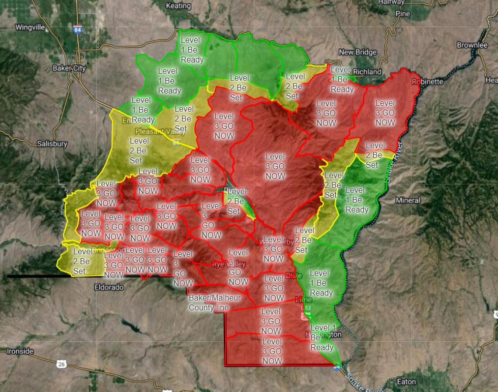
Baker County Evacuation Levels Update 1157 am 07 25 2024
Related Incident: Durkee Fire
Publication Type: Announcement
Due to the fire activity, evacuation levels have been updated. Many areas have been reduced to a lower level and others have been eliminated.
The most significant change is that the Level 1 (BE READY) near the southern outskirts of Baker City has been eliminated.
The City of Huntington and Snake River Road have been reduced to a Level 1.
We would like to remind folks to remain vigilant due to the potential for rapid fire growth, which could prompt evacuation levels to change again.
Malheur County Evacuation Levels Update 1145 am 07 25 2024
Related Incident: Durkee Fire
Publication Type: Announcement
Evacuation update 7/25/24
All evacuation recommendations for the Durkee and Cow Valley fires in MALHEUR COUNTY ONLY are lifted.
We do have some additional small fires in the County from yesterdays lightning. We will continue to monitor them and put information out as needed.
Fire danger is still very high so please be mindful of that in everything you do. There is a county wide burn ban in place which includes burning in well irrigated areas. Please DO NOT BURN.
Pyramid and Slate Fires Smoke Outlook 07 26 2024
Related Incident: Pyramid and Slate Fires
Publication Type: Announcement
Several fires on the Willamette National Forest and other portions of the country are contributing to smoky conditions in the surrounding communities. Citizens can view maps and updates about smoke and air quality conditions by visiting this website Using AirNow During Wildfires | AirNow.gov
Red Fire Daily Update 07252024 07 25 2024
Related Incident: Red Fire
Publication Type: News
RED FIRE UPDATE
July 25, 2024
Fire Information Line - 541-316-7711
centraloregonfire.org x.com/CentralORFire
Inciweb: https://inciweb.wildfire.gov/incident-news/ordef-red-fire
Size: 389 acres | Location: 5 miles west of Crescent Lake Junction, Oregon
County: Klamath | Start Date: July 17, 2024 | Containment: 0% | Cause: Lightning
Total Personnel: 206
Klamath County, Oregon — The Red Fire is located within the Diamond Peak Wilderness on the Deschutes National Forest, on the southwest slope of Redtop Mountain. The fire is being managed under a full suppression strategy. The Southern Area Gray Incident Management Team, led by Incident Commander Fulton Jeansonne, assumed command of the fire on Friday, July 19, at 6:00 a.m. local time. Public and firefighter safety is the highest priority in managing this fire.
The Diamond Peak Wilderness encompasses 52,500 rugged acres straddling the crest of the Cascade Mountains. It was designated in 1964 by the Wilderness Act, to be stewarded in its natural, undeveloped condition. Motorized equipment, motor vehicles, and aircraft are prohibited in Wilderness by federal law, with narrow criteria for exceptions. The USDA Forest Service has authorized the use of chain saws, portable pumps, fire retardant, and aircraft landings by firefighters on the Red Fire since initial attack.
A Red Fire Community Meeting was held on Monday July 22. A recording is available here.
Yesterday’s Activities – Firefighters continued to assess and scout opportunities for control features near the current fire footprint within the Wilderness. Construction of the shaded fuel break by both hand crews and heavy equipment continued southwest of the Crescent Lake Junction community; along the west side of the Union Pacific Railroad tracks to the north, and along the north side of Forest Service Road 60 near Crescent Lake working southwest.
The fire grew actively in the late afternoon under full sunlight and low humidity. An infrared aircraft flight last night provided updated acreage.
Today’s Activities – Firefighters will continue to monitor the fire within the Diamond Peak Wilderness, and assess and scout opportunities for control features near the current fire footprint. Hand crews, engines, and heavy equipment will continue to construct the shaded fuel break along the west side of the Union Pacific Railroad tracks and on the north side of Forest Service Road 60 southwest of the community of Crescent Lake Junction.
A shaded fuel break thins dense tree stands to reduce a fire’s intensity while retaining enough shade to slow down ground fire, and provides a contingency point for holding the Red Fire, if needed.
Command of the Red Fire will transition from the Southern Area Gray Team to the Eastern Area Team 1 Complex Incident Management Team (CIMT) tomorrow, Friday July 26.
The Southern Area Gray Team deeply appreciates all the support and cooperation received from the public, cooperators, stakeholders, and the Forest Service during our time on the Red Fire.
Weather – Sunny and slightly cooler today, with patchy morning smoke increasing in the afternoon. Temperature around 70, humidity 25-31 percent, which is drier than yesterday. Winds will be from the west at 5-10 mph. Overnight temperature will be 42-45 degrees with light winds and humidity near 60 percent.
Evacuation Notice – The “WILDFIRE! Level 1 – BE READY to Evacuate” notice issued by Klamath County Emergency Management for the Crescent Lake, Odell Lake, and Crescent Junction area remains in effect. For information, or to sign up for alerts, visit: https://www.klamathcounty.org/300/emergency-management
( Klamath County Emergency Management. INCENDIO FORESTAL! Nivel 1 - ESTÉ PREPARADO para evacuar de las siguientes zonas: Crescent Lake, Odell Lake, Crescent Junction ).
Red Fire Area Closures – The Deschutes National Forest has implemented an emergency closure for the area around Crescent Lake and the DIamond Peak Wilderness. The closure has been implemented for public and firefighter safety as heavy equipment works in this area constructing a shaded fuel breakas well as due to proximity to the fire. Working equipment has the potential to throw woody material and rocks over 300 feet.
For information on the Red Fire Emergency Closure, visit the Deschutes National Forest website at: https://www.fs.usda.gov/alerts/deschutes/alerts-notices/?aid=89091
Fire Restrictions – Stage 2 Public Use Fire Restrictions which prohibit open fires including in developed campgrounds are currently in effect for the entire Deschutes National Forest. Visit the Deschutes National Forest’s website (fs.usda.gov/detail/deschutes/home/?cid=stelprdb5297376) for more information.
Smoke from the Red Fire and other area fires will continue to impact air quality. Air quality information can be found at https://fire.airnow.gov/.
A Temporary Flight Restriction is in place over the fire area. If you fly, we can’t. Unauthorized drone flights (UAS) pose serious risks to firefighter and public safety and the effectiveness of wildfire suppression operations. Aerial firefighting is suspended when unauthorized UAS are in the area, allowing wildfires to grow larger.
###
Diamond Complex Daily Update 07 25 2024
Related Incident:
Publication Type: News
July 25, 2024
Fires resulting from a lightning storm on July 16 on the Diamond Lake Ranger District of the Umpqua National Forest are under a full suppression strategy, managed as the Diamond Complex.
Currently there are 23 fires totaling an estimated 4,146 acres in the Diamond Complex, with 370 personnel assigned. The Complex is 3% contained. Firefighters are directly attacking the fires’ edge where access and firefighter safety allow, and implementing indirect strategies using constructed control lines, and utilizing natural barriers where access issues and safety concerns prevent direct attack.
Nationally and in the Pacific Northwest, fire activity is putting an extreme demand on firefighting resources. This means that firefighters must carefully prioritize and efficiently utilize available resources to protect values at risk. The highest priority will remain public and firefighter safety and protecting infrastructure and homes.
The fires comprising the Diamond Complex are: Pine Bench, 1,546 acres, and 0% contained, north of Hw138 near Dry Creek; Trail, 830 acres and 5% contained, east of Hwy 138 on the west slope of Mt. Thielsen; Lemolo, 627 acres and 0% contained, north of Lemolo Lake on Bunker Hill; Pig Iron, 27 acres and 25% contained, Pig Iron Mountain north of Hwy 138; Watson, 166 acres and 0% contained, north of Hwy 138 on Watson Ridge, Brodie, 98 acres and 0% contained, about 5 miles south of Hwy 138 and south of Devils Canyon; Trep, 109 acres and 0% contained, about 4 miles south of Hwy 138; Garwood, 5 acres and 65% contained, about 3 miles southwest of Mt. Bailey; Slide, 0.1 acres and 90% contained, northeast of Pine Bench; Potter, 504 acres, north of Hwy 138 about 2 miles southeast of Potter Mt.; Ooya, 136 acres, north of Hwy 138 about 1 mile northeast of Bird Point; Clearwater, 1 acre and 90% contained, south of Hwy 138 about 5 miles northwest of Diamond Lake; Elephant, 0.7 acres and 0% contained, 2 miles southwest of Lemolo Lake; Lost Bear, 5 acres and 0% contained, 2 miles south of Hwy 138, Lost, 14 acres and 0% contained, 4 miles south of Hwy 138; Loafer, 24 acres 0% contained, one-half mile north of Watson Ridge; Sheep, .3 acres and 0% contained, 3 miles north of Diamond Lake Thin, 1 acre and 0% contained, four miles northwest of Diamond Lake; Trap, 4 acres and 0% contained, 1 mile south of Hwy 138 near Trap Mountain; Bear Trap, 45 acres and 0% contained, 2 miles south of Hwy 138 near Bear Trap Mountain; Campwood, 8 acres and 0% contained, 2 miles south of Hwy 138; Rough, 8 acres and 0% contained, two miles south of Hwy 138, and two new starts (unnamed) totaling nine acres, 0% contained, one north and one south of Hwy 138.
Yesterday, firefighters continued active suppression on all fires, with the Trail, Pig Iron, Lemolo and Pine Bench fires as priorities. Lemolo has become the highest priority fire to protect critical infrastructure. On the Lemolo fire, fire line is established on the east and northeast of the 700 road. Firefighters are working directly on the Watson Fire. The Potter fire has crossed into the Willamette National Forest. On the Pig Iron fire, work continues to get the fire into patrol status. Firefighters worked to keep the Pine Bench fire west of Forest Road 4775, and successfully suppressed several spot fires. Several of the newly identified fires were successfully attacked and contained.
Today, firefighters will continue direct suppression on accessible fires, and will develop specific suppression strategies for other less accessible fires to be carried out as resources become available.
Weather: Today will be slightly cooler with higher humidity and lighter winds. While these conditions favor firefighting, very dry forest fuels and steep terrain will still allow persistent fire spread.
Closures and Evacuations: Umpqua National Forest has issued two closures across the forest in response to fire activity to protect public and wildland firefighter safety. Emergency Fire Closure ORDER NO. 06-15-24-03 and Emergency Fire Closure ORDER NO. 06-15-02-24-01 which impact all of the Cottage Grove Ranger District, most of the Diamond Lake Ranger District, and parts of the Tiller and North Umpqua Ranger Districts. The closure orders can be found here: https://www.fs.usda.gov/alerts/umpqua/alerts-notices. Additionally, Diamond Lake, Thielsen View, and Broken Arrow Campgrounds are closed through July 28, 2024, and will be reevaluated closer to that date. Fire danger is set at High and Public Use Restrictions are set at Level 2: https://bit.ly/3xIZZdK.
Douglas County Sheriff has issued a Level 3: GO NOW and Level 2: BE SET for the Trail Fire and Lemolo Fire. There is a Level 2: BE SET for the Pine Bench Fire. Please see detailed information here: www.dcso.com/evacuations.
Battle Mountain Complex Zone II 07 25 2024
Related Incident: Battle Mountain Complex
Publication Type: News
Boneyard Fire merges into Monkey Creek Fire
UKIAH, Ore. – Overnight, the Boneyard Fire merged into the Monkey Creek Fire, now only referred to as the Monkey Creek Fire. Fire officials zoned the Battle Mountain Complex into Zones I and II, with ODF Incident Management Team 1 managing the west portion of the complex and ODF Incident Management Team 3 managing the east. Zones are used for effective management and resource allocation.
In Zone II, firefighters continued to see active fire behavior, slop overs and spot fires across the south of the fire overnight. Crews are focused on the southeast corner of the fire, where they are focused on fire suppression and constructing lines.
Along the south, structural taskforces built defensible space and provided direct suppression around homes and outbuildings. Overnight, the fire moved into the Pass Creek and Long Creek drainages and flats.
Along Highway 395 and the eastern edge of the fire, crews will continue firing operations down to the roadway, and the Oregon Department of Transportation will continue removing hazard trees along the road. Tree removal will continue over the coming days with heavy equipment using the roadway.
Firefighters may see a slight reprieve in temperatures, but still hot conditions, as winds come in from the west and southwest. Conditions will bring increased wind gusts.
The 4,485-acre North Fork Owens Fire is now 50% contained (the complex stands at 5% containment).
The Battle Mountain Complex consists of the North Fork Owens and Monkey Creek Fires – two of 17 fires in northeast Oregon that started in the late afternoon and evening of July 17, 2024. The Snake Fire merged with the Monkey Creek Fire on July 22, 2024, and the Boneyard Fire merged with Monkey Creek Fire on July 25, 2024.
Evacuations: Level 1 (Be Ready), Level 2 (Be Set) and Level 3 (Go Now) evacuations are in effect. For updated information, visit:
- For Umatilla County, follow facebook.com/UmatillaCountySheriff or sign up for Umatilla County Emergency Alert System at https://member.everbridge.net/index/2590041373147145.
- For Grant County, visit the RAPTOR arcgis site or sign up for alerts at: https://member.everbridge.net/index/825462649520134.
- For Morrow Couty, visit https://experience.arcgis.com/experience/
de78333b0d2544f7a320142174aa20ae