
Blacktail Canyon Fire Morning Update 07 26 2024
Related Incident: Blacktail Canyon
Publication Type: News
Blacktail Canyon Fire Update
Incident Commander J. Willoughby
Location: southeast of Butte, MT between Interstate 90 and Highway 2
Start Date: 7/19/2024
Cause: Undetermined
Size: 80 acres
Resources on Site: 4 engines, 1 helicopter, 2 type 1 “hotshot” hand crews, 3 type 2 hand crews
Total Personnel Assigned: 152
Containment: 50%
KEY MESSAGES:
The evacuation warning issued by Butte-Silver Bow Law Enforcement Department has been rescinded.
Winds associated with passing thunderstorms pose a major safety hazard due to the high density of “snags” and falling trees. Additionally, the proximity of the fire location to recreation sites such as the Continental Divide Trail and the Silver Bow Archery Range in Thompson Park presents a further need for public awareness. The public is advised to stay out of these areas, as crews and helicopters continue their work. Ensuring firefighter safety and protecting life and property are of the utmost importance during any incident.
CURRENT STATUS/PLANNED ACTIONS:
Previously constructed firelines held, despite the gusty winds and Red Flag conditions. The acreage remains at 80. Yesterday, crews worked in the morning until the predicted high winds materialized, forcing the crews off the fireline and back to fire camp due to the snag and falling tree hazards. Firefighting efforts resulted in securing sections of the fire edges, 3 chains (198 feet) into the interior.
Fire managers are calling the fire 50% contained. Containment of a fire implies there are secure firelines around the perimeter, directly next to the edge where the fire burned. As the crews progress around the entire fire perimeter with “mop-up” and extinguish all residual heat interior to the fire edge, the containment percentage will increase.
Infrared mapping identified an area of residual heat on the eastern flank, given the winds yesterday. Crews will address this section today as they continue with “mop-up” operations, as allowed by weather conditions and subsequent impacts of the gusty winds. Engine crews and helicopters will be available for initial attack of new fires, given the recent lightning and several smoke reports in the area.
WEATHER AND FIRE BEHAVIOR:
Fire behavior was minimal yesterday, with smoldering observed. Little to no smoke was visible.
A cold front moved through the fire area yesterday. Mostly clear skies will dominate the forecast today. West winds will increase in the afternoon hours today and tomorrow. Relative humidity will remain low, with readings in the teens. A slight chance for showers enters the area on Saturday.
Pyramid and Slate Fires Daily Update 07 26 2024
Related Incident: Pyramid and Slate Fires
Publication Type: News
PYRAMID FIRE:
East of Middle Santiam Wilderness, 615 Acres, 5 Percent Contained, Total Personnel, 280, Lightning caused
Yesterday, bulldozers, masticators, and heavy equipment finished building most of the control line around the fire perimeter using the existing road system. Today, hand crews will work on completing a small section of the control line in rocky terrain on the north flank. They will also continue to improve existing control lines using masticators and chippers. The goal is to widen and improve the control lines, and reinforce them with hose and pumps, especially on the southern flank.
SLATE FIRE:
5 miles SW of Detroit, OR, 45 Acres, 11 Percent Contained, Total Personnel, 47, Under Investigation
Yesterday was a very successful day as firefighters, assisted by helicopters and water-scooping planes, aggressively attacked the fire. On the northern perimeter, dozers built a control line east along the 548 Road to the ridgeline. On the southern flank, along the 549 Road, crews worked to construct a control line and install sprinklers at the edge of the fire. In addition, a smokejumper crew started from the 549 Road and began working on the west flank, building a direct hand line. Today, firefighters will continue direct hand line construction at the fire’s edge to secure a control line around the fire.
WEATHER: Last night, skies were clear with moderate to good humidity recovery. Today will be sunny, warmer, and drier, with typical afternoon northwest winds.
SMOKE IMPACTS: Several fires on the Willamette National Forest are causing smoky conditions in surrounding communities. Citizens can check smoke and air quality conditions on this website: AirNow.gov
ROADS: Please be mindful of firefighting equipment when driving in the area. Refer to the emergency closure order for forest roads affected by the fires. For information about all other roads, visit the Oregon Department of Transportation website at https://tripcheck.com
EVACUATIONS: On July 17th, the Linn County Sheriff’s Office, in coordination with the Forest, issued a Level 3: Go Now Evacuation Alert for the closure area affected. Please refer to the Linn County Fire Map https://tinyurl.com/LinnCoFireMap for full details of the issued evacuation area (which will appear in red).
CLOSURES AND FIRE RESTRICTIONS: Area, road, recreation sites, and trail (including the PCT) closures are in effect in the Willamette National Forest due to nearby fires. For specific information, please follow this link: https://www.fs.usda.gov/detail/willamette/alerts-notices/?cid=fseprd552029
Fire restrictions have been implemented for Willamette National Forest, including the Three Sisters, Mt. Jefferson, Mt. Washington, Waldo Lake, and Diamond Peak Wilderness areas. Read the complete restrictions at: https://www.fs.usda.gov/alerts/willamette/alerts-notices/?aid=81487
Whisky Creek Fire Daily Update 07 26 2024
Related Incident: Whisky Creek Fire
Publication Type: News
Whisky Creek Fire Daily Update
July 26, 2024
Email: 2024.whiskycreek@firenet.gov
Incident Information Phone Line: 541-208-1743 – daily 8 a.m. to 8 p.m.
Whisky Creek Fire Facebook: https://www.facebook.com/2024WhiskyCreekFire
InciWeb: https://inciweb.wildfire.gov/incident-news/ormhf-whisky-creek-fire
Smoke Report: https://www.airnow.gov/
Whisky Creek Fire
0% Contained
856 Acres
6 miles SE of Cascade Locks, OR
Burning in scrub oak, timber, woody debris, and grass
Highlights
Crews made progress on preparing containment lines to the south of the active fire area yesterday. Heavy equipment was brought in to assist with clearing roads and creating fuel breaks reopening an Eagle Creek Fire contingency line. Conditions were also favorable for an infra red flight allowing for better mapping of the area and a more accurate number of acres burned.
Operations
Crews continue to prepare containment lines, clearing roads and trails, to the southeast along the Rainy-Wahtum Trail #409 from Rainy Lake to Wahtum Lake and continuing to the Pacific Crest Trail (PCT) approximately one mile to the 2017 Eagle Creek Fire burn area. A temporary reroute of the PCT to the Eagle Creek Trail is expected. To the east of the fire, crews continue to strengthen a containment line along the Gorton Creek Trail #408 and identifying potential contingency lines further east. Crew will continue to do fuels reduction work and tie in indirect line along the edge of the wilderness area.
Fire Behavior & Weather
The fire is burning within the Mark O. Hatfield Wilderness and moving steadily along the eastern edge up Woolly Horn Ridge and west towards Waucoma Ridge. Moderate upslope growth is expected to continue around the fire’s edges with potential for wind to push to the south. Smoke will continue to be visible, especially in the afternoon, as fire consumes denser pockets of vegetation and dead-and-down fuels. Decreasing humidity and light and variable winds will allow for warmer and drier conditions over the area today. This may increase fire activity and smoke, especially in the afternoon.
Evacuations, Road and Trail Closures, and Restrictions
The Mt. Hood National Forest and the Columbia River Gorge National Scenic Area have issued a joint emergency closure for the fire area. Closure information can be found on the Mt. Hood National Forest website Alerts & Closures page at: Whisky Creek Fire Closures in Mark O. Hatfield Wilderness.
Total Fire Resources Assigned
- Approx. 244 personnel, 5 hand crews, 5 water tenders, 2 dozer, and 2 helicopters.
July 24 Community Meeting video 07 26 2024
Related Incident:
Publication Type: Announcement
The recorded video from the community meeting on July 24 is found here: https://www.facebook.com/share/v/2KTb1duie5G8vmWz/
Daily Update Swawilla Fire and Bridge Fires 72624 07 26 2024
Related Incident: Swawilla Fire
Publication Type: News
Friday July 26, 2024 Update for Swawilla and Bridge Creek Fires
Evacuation areas remain at a Level 3 around the Swawilla Fire.
Highway 155 remains open. See chart for closures.
See Inciweb Site for locations and evacuation boundaries.
The Incident Team will host a community meeting on Friday, July 26 at 7pm at the Nespelem Head Start Center, 19 Wenatchi St.
FIRE ACTIVITY: Fortunately, Thursday’s forecast winds were not as strong as predicted and the fire was less active than feared. High temperatures and low humidity did allow it to grow, just more modestly. More seasonable weather with a lighter west/southwest wind should be around through the weekend.
Swawilla Fire
The line along the Swawilla Basin, at the heel of the fire, is considered contained. Along the Peter Dan Road, firefighters were able to do point protection around structures and were supported by retardant drops. The fire made one attempt to cross the Peter Dan road and was stopped by a Type 1 hot shot crew. On the other side of the fire, flames pushed against the lower Manilla Road but did not cross it. Fire moved into some of the drainages southwest of Keller and made its way to the top of Mt.Tolman. It is now backing down the north side towards Meadow Creek. Fuels on this side of the mountain are greener, slowing progression.
The priority of fire management continues to be life and structure protection, however the incoming, more moderate weather after the cold front, provides a good opportunity for more direct attack on the fire. Crews are scouting for terrain features, such as old roads and dozer lines, to continue containment line efforts to reduce further spread to the east.
More resources are showing up daily and some are able to shift from the Bridge Creek Fire to support actions on the Swawilla Fire. A night shift and a swing shift are in place allowing for around-the-clock work on the line. These firefighters, engines, machinery and firefighting infrastructure require more space to house so the Forward Operating Base (FOB) has moved from Keller to a 20-acre camp near the intersection of Agency Cutoff Road and Cache Creek Road. The Incident Command Post remains at the Nespelem Community Center.
Even with the favorable change in the weather, forecasting models still indicate a chance that the fire will reach the town of Keller, push towards the Cache Creek Road, and impact the Buffalo Lake area. For this reason, evacuations remain in place. Community leaders are regularly evaluating these orders with the incident management team. The team appreciates the community’s patience with this process.
An evacuation center is open at the Lake Roosevelt High School gym in Coulee Dam. The shelter at the Paschal Sherman Indian School in Omak is full. Keller Ferry is open only for limited service to assist with evacuations.
Bridge Creek Wildfire
The Bridge Creek Fire is looking good. Firefighters are monitoring the line and working to extinguish hot spots on the east side of the fire. Opening the Bridge Creek Road is a priority and crews are focusing significant time in removing fire weakened trees that may fall on Bridge Creek Road and threaten the safety of the public when the road opens.
Additional Information and Maps at https://inciweb.wildfire.gov/, https://www.facebook.com/CCTENV, https://www.facebook.com/CCTBroadcasts
Courtrock Fire Morning Update 07 26 2024
Related Incident: Courtrock Fire
Publication Type: News
Firefighters focus on southern portion of Courtrock Fire, work to control spread
MONUMENT, Ore. – A public meeting was held Thursday night in Long Creek to provide fire information for the communities surrounding the Courtrock Fire and the western portion of the Monkey Creek Fire in the Battle Mountain Complex. The video from the meeting can be accessed at https://youtu.be/rvudySyUGok
Firefighters will work today to complete line on the southern area of the fire where it has continued to be active. Line construction using bulldozers and handline is planned, along with using strategic firing operations to remove fuel and vegetation between the fire’s edge and indirect fireline, creating a larger and stronger barrier between the fire and homes to the southeast.
Lower temperatures and higher relative humidity will aid in the firefighting efforts this morning, however the forecast calls for north winds to increase this afternoon. Fuels in the area are dry and firefighters are aware of the potential for increased fire behavior during these windows and will be watching for changes.
On the north side of the fire, firefighters have been able to secure a longer portion of line, resulting in an increase in containment to 9%. Resources will continue to build on this work as well today.
Information for Zone I of the Battle Mountain Complex, including the western portion of the Monkey Creek Fire (formerly Boneyard Fire) can now be found at: www.facebook.com/battlemountaincomplex2024
Evacuations: Level 1 (Get Ready), Level 2 (Be Set) and Level 3 (Go Now) evacuations are in effect. For updated evacuation information:
- Grant County Emergency Management Office’s Facebook page, or sign up for the Grant County Emergency Alert System at https://member.everbridge.net/825462649520134/login. Morrow County Evacuation information can be found at https://experience.arcgis.com/experience/de78333b0d2544f7a320142174aa20ae
Shelters: An evacuation center has been set up at Grant Union High School (911 S Canyon Blvd., John Day, OR 97845).
Clean air and cooling centers are located in the following locations in Grant County:
- Grant County Library- cooling & clean air, Monday – Thursday 11 a.m. - 5:30 p.m.
- John Day Senior Center- cooling & clean air, Monday & Thursday 10 a.m. – 5 p.m., Tuesday 12 – 4 p.m.
- Prairie City Public Works - clean air center, Monday - Friday 12 – 7 p.m.
- Dayville Community Hall- cooling & clean air, 24/7
2024 SQF Lightning Daily Incident Update 07 26 2024
Related Incident: 2024 SQF Lightning
Publication Type: News
Trout Fire: 22,231 acres - 20% containment
Long Fire: 9,204 acres - 30% containment
Borel Fire: 3,092 acres - 0% containment
Total Personnel: 1,117
Current Situation: Over the last week tremendous progress has been made on the Trout Fire and Long Fire. Containment continues to increase, and the work of building control lines remains a priority. The appropriate resources remain assigned to each fire to ensure containment continues to increase. On the Borel Fire today, a wave of resources are being sent into communities to provide structure protection. Additionally, firefighters will continue with their assignment to create a control line from Hwy 178 along the fire’s southern edge toward Breckenridge Meadows and Havilah. Evacuation warnings and orders have been issued for multiple zones (see below). Everyone in areas of active fires should “Know Your Zone.” Go to genasys Protect (tinyurl.com/jcdv55f9) to identify the zone you reside in.
Trout Fire: Fire growth was minimal Thursday despite warm, dry, windy conditions, allowing crews to make significant progress suppressing hotspots directly on the fire’s edge. On the western perimeter, dozer operators have nearly completed fireline construction to Big Meadow. On the southern perimeter, crews camping in the Domeland Wilderness are extinguishing lingering areas of heat and constructing handlines from Sirretta Pass toward Smith Meadow.
Long Fire: Fire activity remains moderate, primarily creeping and smoldering. Some unburned pockets of vegetation on the fire’s interior may continue to produce smoke. However, crews report there are no areas of heat posing a threat to their existing containment lines. Firefighters are constructing handlines from the head of the fire near the Pacific Crest Trail, moving southwest toward Palome Creek.
Borel Fire: Wednesday afternoon, the Borel Fire started burning along State Route 178 near Democrat Springs. Yesterday, under red flag weather conditions the fire exhibited extreme fire behavior and grew to more than 3,000 acres. Since its start, firefighters have successfully kept the fire south of SR 178. The Democrat Fire Station was threatened yesterday, but crews made a stand and defended it. Today, operations will focus on protecting Breckenridge Meadows, Piute Meadows Ranches, and Havilah, while maintaining the strong control line of SR 178. A vast army of resources will be attacking the fire from the air and ground, including resources from the Kern County Fire Department to benefit from their local knowledge of the areas affected.
Weather & Air Quality: The National Weather Service issued a Red Flag Warning through Saturday, July 27 at 11 p.m. for low relative humidity and elevated winds. Fire behavior on new and existing fires could be extreme. Hot, dry conditions are expected today with wind gusts up to 35 mph possible. Westerly winds will remain elevated on ridgetops throughout Friday night. A daily smoke outlook is produced for the areas and communities affected by the 2024 SQF Lightning fires: tinyurl.com/452x2uzr.
Sequoia National Forest & BLM Closures & Restrictions: Sequoia National Forest lands, roads, trails, and recreation sites around the Trout and Long Fires are temporarily closed under Forest Order No. 0513-24-12. Fire restrictions are also in effect under Forest Order No. 0513-24-10. Both orders, maps, and accompanying appendices can be found on the Forest’s “Forest Orders” web page: tinyurl.com/2en2d36k. The Bureau of Land Management’s Bakersfield Field Office has temporarily closed Long Valley Campground, Chimney Creek Campground, and portions of the Pacific Crest Trail. View the emergency closure order here: tinyurl.com/4mprcb9b. The PCT is closed between Hwy 178 at Walker Pass (mile 653) and the South Fork of the Kern River bridge (mile 717.7).
Evacuation Center: Residents under an evacuation warning or order can go to the Tehachapi Education Center, 126 S. Snyder Ave., Tehachapi, CA 93561. Animal services will assist with sheltering animals at the center.
Road Closures: State Route 178 is closed from 4.1 mi east of the junction of SR 184 to Democrat Springs. View the interactive Caltrans map for the most current road closure information: quickmap.dot.ca.gov/.
Evacuations: Kern County has multiple evacuation orders and warnings in effect due to the Borel Fire. The following zones are under an evacuation order: KRN-403-A, KRN-737, KRN-738. The following zones are under an evacuation warning: KRN-740, KRN-741, KRN-742, KRN-736, KRN403-B. Tulare County evacuation warnings are in effect for zones TLC-E274-B and TLC-E261-B. Tulare County evacuation advisories are in effect or zones TLC-E297-A, TLC-E250, TLC-E274-A, and TLC-E261-A. Everyone in areas of active fires should “Know Your Zone.” Go to genasys Protect (tinyurl.com/jcdv55f9) to identify the zone you reside in.
Retreat Fire Update 07 26 2024
Related Incident: Retreat
Publication Type: News
Retreat Fire
Northern Rockies Team 1, Incident Commander Brent Olson
Location: 14 miles southwest of Naches, WA
Start Date: July 23, 2024
Cause: Under Investigation
Size: 13,183 acres
Resources: 216 Total Personnel; 1 Dozers; 0 Helicopters; 7 Hand Crews; 15 Engines
KEY MESSAGE:
Northern Rockies Complex Incident Management Team 1, Incident Commander Brent Olson took command of the Retreat Fire at 6 am this morning.
CURRENT STATUS:
Northern Rockies Incident Management Team 1 has been assigned responsibility for managing fire suppression activities as delegated by agency jurisdictions beginning 6:00 am on July 26. The fire is being managed under a full suppression strategy with public and firefighter safety as the number one priority. The Retreat Fire is estimated at 13,183 acres, burning southwest of Naches, WA. Active fire behavior may be observed due to forecasted winds and smoke lifting out of drainages. Heavy equipment and hand crews will construct direct and indirect control lines along the northern and southern fire perimeter to reduce the fire’s advance.
WEATHER AND FIRE BEHAVIOR:
Weather is dominated by an upper-level trough with increasing winds projected for this weekend. Maximum daytime temperatures above 90 degrees. Winds are expected to be variable, 4 to 7 miles mph from the west changing direction from the east in the afternoon between 5-10 mph feet above ground level. Minimum humidities are expected to be between 13 and 23 percent. Three primary fuel types are present in the fire landscape: Oak bottoms, grass sage brush, and Ponderosa pine with some mixed conifers. The oak bottoms and grass/sage are very dry and readily available to burn, isolated group and single tree torching may create potential for spotting.
CLOSURES AND EVACUATIONS:
- Level 3 “GO NOW” Evacuation Advisory from US Hwy 12 at Bear Canyon Trailhead (NF 1301 Forest Service Road) northeast to the “Y” (Hwy 12/410). From “Y” (Hwy 12/410) south along the borders of Town of Cowiche and Town of Tieton to Cowiche Mill Road. Cowiche Mill Road west to NF 641 Forest Service Road.NF 641 Forest Service Road North to Hwy 12.
- Level 2 "GET SET" Evacuation Notice for the City of Tieton, WA area including Cowiche Mill Road east to Summitview Road, Summitview Road North to the four way stop on West Tieton Road, heading west on West Tieton Road to the end of West Tieton Rd. The west boundary is the end of West Tieton Road going south to the 3600 block of Cowiche Mill Road. For the evacuation boundary visit the Yakima County Office of Emergency Facebook page: www.facebook.com/YakimaCountyOEM/.
- US Hwy 12 remains closed for several reasons between the Y at Hwy 410 and the summit of the Pass at milepost 151.
- Okanogan-Wenatchee National Forest Retreat Fire Area Closure: www.fs.usda.gov/alerts/okawen/alerts-notices/?aid=89192.
- The Washington State Department of Natural Resources (DNR) Southeast Region has temporarily closed the Ahtanum State Forest due to increased activity from the adjacent Retreat Fire burning near Rimrock Lake. The public can access the most up-to-date closure information at www.dnr.wa.gov/ahtanum.
Badland Complex Daily Update 07 26 2024
Related Incident: Badland Complex 2024
Publication Type: News
Rocky Mountain Area Complex Incident Management Team Two
Jared Hohn, Incident Commander
Current Situation:
- The Badlands Complex has grown to 51,196 acres and is 0% contained with 127 personnel assigned.
- Yesterday, the complex utilized two fixed wing Scoopers on the Coyote and Powder fires. Two Type 1 helicopters were available as a shared resource with other local firefighting efforts. An Air Attack platform was also available and used to obtain a view over the fire area.
- The Powder fire has shown little fire activity over the past two days. The Scoopers dropped water on pockets of persistent heat yesterday. With aerial support, a small number of ground resources are patrolling and holding the Powder fire in check.
- The Coyote fire made a push to the west over the past two days. The Scoopers were used to check the fire’s progression south of Richland near the mouth of Daly Creek and Myers Gulch.
- On the Thompson fire, firefighters have been working aggressively in the Sisley Creek area to secure the fire’s edge and protect structures in that area. Dozers and engine crews are working west of Thompson fire, improving the Iron Mountain Road to establish containment in rough, broken country.
- Additional fire crews are beginning to arrive to relieve local resources. Ground crews are aggressively engaging the fire when and where weather, fuels, and terrain allow. Aircraft are being used when they are available. Nationally, there is a high level of fire activity demanding a limited supply of shared interagency firefighting resources.
Evacuations: Baker County Sheriff’s Office has issued Level 1, 2, and 3 evacuation orders for multiple areas of the fire. Learn more at https://www.facebook.com/profile.php?id=100064434892363. A temporary evacuation shelter has been established at the Baker City Church of the Nazarene Family Life Center located at 1250 Hughes Lane. For questions about the temporary shelter, please contact the American Red Cross at 1-800-733-2767.Sign up for Baker County emergency alerts at https://public.alertsense.com/SignUp/publicUser.aspx?regionid=1357
Closures: Check for highway closures at https://www.tripcheck.com/DynamicReports/Report/RoadConditions. All BLM Vale District Recreation Sites along the Snake River between Oxbow and Huntington and on Lookout Mountain are closed. This includes Spring Recreation Site, Swedes Landing, and Bassar Diggins Campground.
Fire Restrictions: Fire Restrictions are in effect. Get details at https://www.blm.gov/sites/default/files/docs/2024-07/orwa-fpo-val-071024.pdf.
Weather & Smoke Information: Weather is expected to be 15 to 20 degrees cooler for the next several days, with high temperatures in the 80s over the fire area. Relative humidity will be somewhat higher than it has been recently, bottoming out around 25%. Northwest winds of 9 – 13 miles per hour may gust to 24 mph.
An air quality advisory is in effect for Baker County due to heavy concentrations of wildfire smoke. For current Oregon air quality conditions, please visit https://oraqi.deq.state.or.us/home/map.
Temporary Flight Restrictions:A temporary flight restriction (TFR) is in effect over the fire area to provide a safe environment for firefighting aircraft operations. View a map of the TFR and details at https://tfr.faa.gov/save_pages/detail_4_7614.html. Fire aviation response is halted or delayed if an unauthorized aircraft enters the TFR. Temporary flight restrictions also apply to unmanned aircraft systems or drones. If you fly, we can’t! Learn more about how to use drones safely and responsibly at Home - Know Before You Fly.
Fire Info Phone: 541-362-1507 Email: 2024.badlandcomplex@firenet.gov Hours: 7:00 a.m. to 7:00 p.m.
Facebook: @BadlandsComplexFires2024 Media Line: 541-249-5894
Inciweb: htinciweb.wildfire.gov/incident-information/orvad-badlands-complex-2024
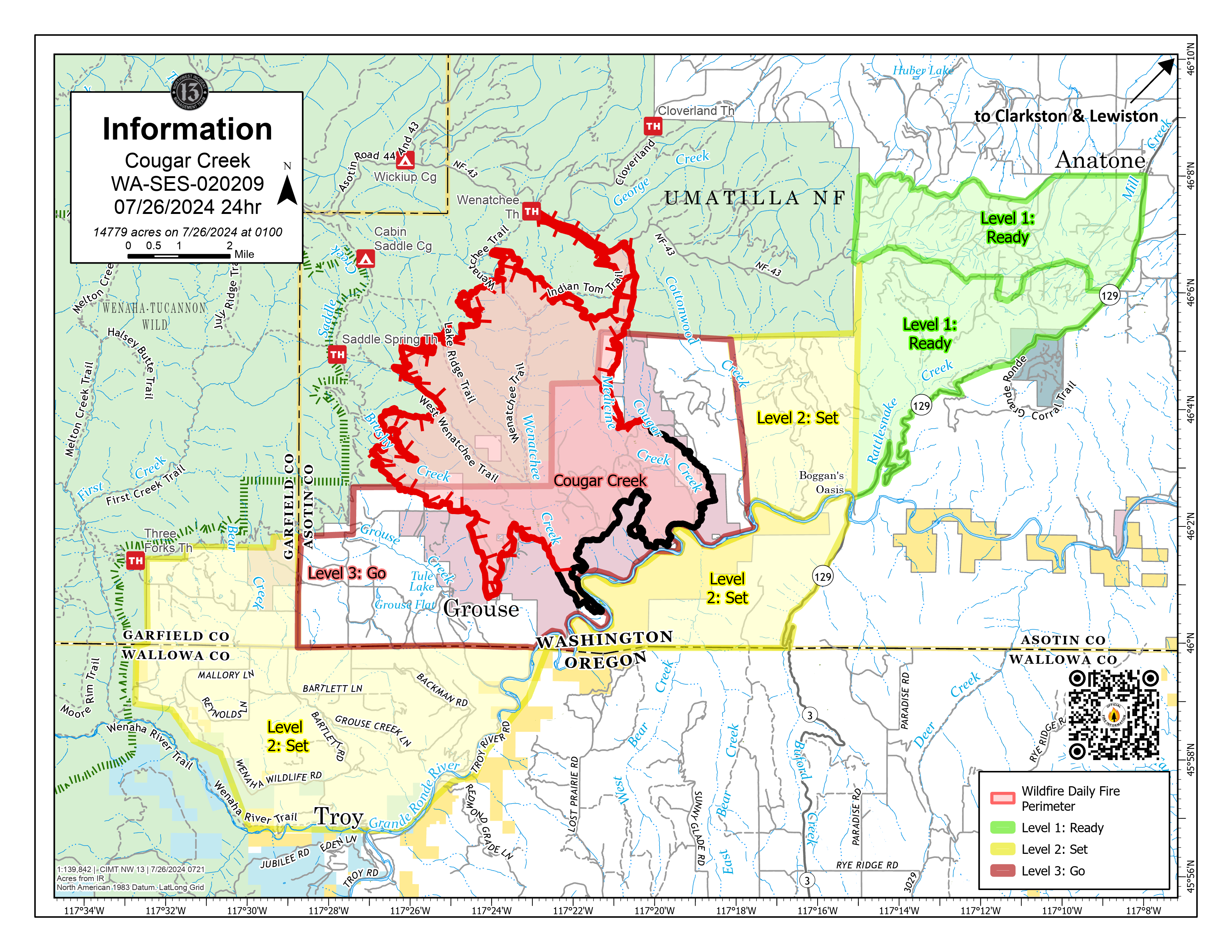
Cougar Creek Fire Update 07 26 2024
Related Incident: Cougar Creek Fire
Publication Type: News
Cougar Creek Fire Update for Friday July 26, 2024
KEY MESSAGES:
Air operations continued on the fire yesterday assisting in securing the perimeter. Incident Officials are working with local communities to provide aerial support including the Bighorn, Gwen and River fires. Department of Natural Resources (DNR) and Initial Attack resources remain to assist in suppression of critical fires in the vicinity. Due to the quick response efforts of DNR crews, initial attack of a lightning strike near Anatone was successfully lined and mopped up.
CURRENT STATUS:
In the Wenatchee Creek drainage, fire crews are working to secure and tie in control lines to the contained flank of the fire. This will free up resources to reengage fire suppression operations on the west flank where firefighters continue to build indirect line. After a successful tactical ignition on the east flank of the fire north of the contained Hanson Ridge area, crews are checking for smoke and hotspots and enhancing direct line construction. Grouse Flats remains a priority to protect property on the southwest side of the fire.
FIRE BEHAVIOR AND WEATHER:
Ridgetop winds will be lighter and will switch back to the southeast. A slight warming trend is still in the forecast for the weekend, along with a chance of thunderstorms again for early next week. Fuels will remain exceptionally dry. These conditions will maintain active fire spread. Fire spread will be in the north and west areas of the fire.
EVACUATIONS AND CLOSURES:
Forest closure descriptions and maps are available online on the Umatilla National Forest Closure page. In Washington, evacuation notices are posted on the Asotin County Sheriff webpage and Asotin County Emergency Management Facebook page. Grande Ronde Road is closed from Troy, Oregon to Highway 129 junction in Washington. In Oregon, a level 2 evacuation is in effect for Wallowa County, including all of Grouse Flat from Bear Creek Rd north to the State boundary and the Garfield County line to Grande Ronde River.