
20240726Pincer Two Fire Press Release 07 26 2024
Related Incident: Pincer Two Fire
Publication Type: Announcement
11:00 AM, July 26, 2024
Estimated size: 82 acres
Start Date/Time: July 17, 2024
Area of Origin: 21 air miles northeast of Darrington WA
Cause: Lightning
Fuels/Topography: Timber, rugged terrain
Structures Damaged: None, there are no homes threatened at this time.
Evacuations: None
Closures:
Campgrounds and Roads: Cascade River Road at and including Marble Creek Campground, Mineral Park Campground, and all tributary roads, trailheads, and trails.
Full closure orders available at: https://www.fs.usda.gov/mbs
Update: Fire personnel were able to complete the clearing and prep work of the 1590 road. Crews are now focusing on brushing and limbing the corridor along the Cascade River Road. Mineral Park Campground signs and buildings are wrapped, and firefighters are working on installing sprinklers. Operations staff has identified other objectives pending fulfillment of firefighters. With multiple fires in the area and nationwide resources are being funneled to highest priority fires where life and personal property are at risk. As resources become available identified suppression effort priorities will be implemented.
Weather: Generally benign fire weather conditions are in store throughout the period as onshore flow dominates. Mid-level instability will be present over the incident site particularly during the afternoon, but the influx of marine air will keep RH above critical values with decent recoveries overnight. West winds between 5 to 10 mph are expected. Max temperatures will be around 71, and relative humidity will be 37%.
Smoke: For more information on smoke and air quality please visit: https://wasmoke.blogspot.com/
Air Space Restrictions: There are no air space restrictions at this time.
Campfire Restrictions: The Mt. Baker-Snoqualmie will be elevating to a full campfire ban, even in developed campgrounds, starting Wednesday July 24, 2024 to help prevent human-caused starts in this critically dry period. Additional details at: www.fs.usda.gov/mbs
##
Battle Mountain Complex Morning Update 07 26 2024
Related Incident: Battle Mountain Complex
Publication Type: News
ODF Teams 1 & 3 coordinate on Battle Mountain Complex Zones I & II, strides made overnight
UKIAH, Ore. – In Zone I, Firefighters on night shift were able to increase containment lines around the southeastern portions of the Battle Mountain Complex Zone I (formerly the Boneyard Fire) overnight, wrapping the southern edge of the fire from Top Road to Wall Creek Road. This work contributes to an overall increase in containment on the incident and will continue to be a focus for resources working on Zone I of the fire today.
Despite cooler temperatures and decreases in wind speed, fire behavior remained active along Zone I’s western perimeter. A spot fire approximately four acres in size was located near Ant Hill, but firefighters were able to quickly line and stop the spot fire’s progress before it could spread any further.
In Zone II, the eastern half of the Battle Mountain Complex, firefighters are taking advantage of the somewhat lower temperatures. With less smoke in the air, more assets are available to more portions of the fire.
“This slight break in the weather is really giving us the time and space we needed to dig in and get some work done” said Deputy Incident Commander, ODF Team 3, Bryce Thomas. “We’re holding more line and tying in key pieces of line to minimize acres. There’s a lot of work left, but we’re cautiously optimistic. I can’t say enough about all the hard work our firefighters and support functions put into this.”
On the southeast portion of the fire, firefighters largely held firelines with minimal growth. Crews constructed dozer line, completed some burn operation to tie together two divisions and began preparations for additional burning. Lines are holding along Highway 395 but many hazard trees and rolling debris remain along the roadway.
Along the southern head of the fire, firefighters continue to scout steep and bluffy terrain to tie together lines. Crews were seeing more success holding lines within the drainages, but the terrain continues to challenge suppression efforts.
Along the north, firefighters continue to construct direct, tight line on the fire’s edge and hope to connect dozer lines today. Structural firefighters, under the command of the Oregon State Fire Mashal, continue to provide protection for residents along the perimeter.
The 4,484-acre North Fork Owens Fire is now 70% contained (the complex stands at 5% containment).
Evacuations: Level 1 (Be Ready), Level 2 (Be Set) and Level 3 (Go Now) evacuations are in effect. For updated information, visit:
- For Umatilla County, follow www.facebook.com/UmatillaCountySheriff or sign up for Umatilla County Emergency Alert System at https://member.everbridge.net/index/2590041373147145.
- For Grant County, visit the RAPTOR arcgis site or sign up for alerts at: https://member.everbridge.net/index/825462649520134.
- For Morrow Couty, visit https://experience.arcgis.com/experience/de78333b0d2544f7a320142174aa20ae
Public Land Closures:
The Bureau of Land Management has closed public lands along the John Day River from Kimberly to Dale, and from Kimberly to Service Creek. More information here: https://www.blm.gov/programs/public-safety-and-fire/fire-and-aviation/regional-info/oregon-washington/fire-restrictions.
The Umatilla National Forest has implemented a closure for public lands within the Heppner Ranger District and the North Fork John Day Ranger District. More information at: https://www.fs.usda.gov/detail/umatilla/news-events/?cid=FSEPRD1194462 and https://www.fs.usda.gov/detail/umatilla/alerts-notices/?cid=stelprdb5286768.
FIRE AT A GLANCE
Total Estimated Complex Size: 151,013 acres
North Fork Owens: 4,484 acres
Containment: 5%
Cause: Under Investigation
Estimated Cost: $7,500,000
All Resources
Hand Crews: 45
Engines: 75
Water Tenders: 34
Dozers: 30
Helicopters: 8
Total Personnel: 1,466
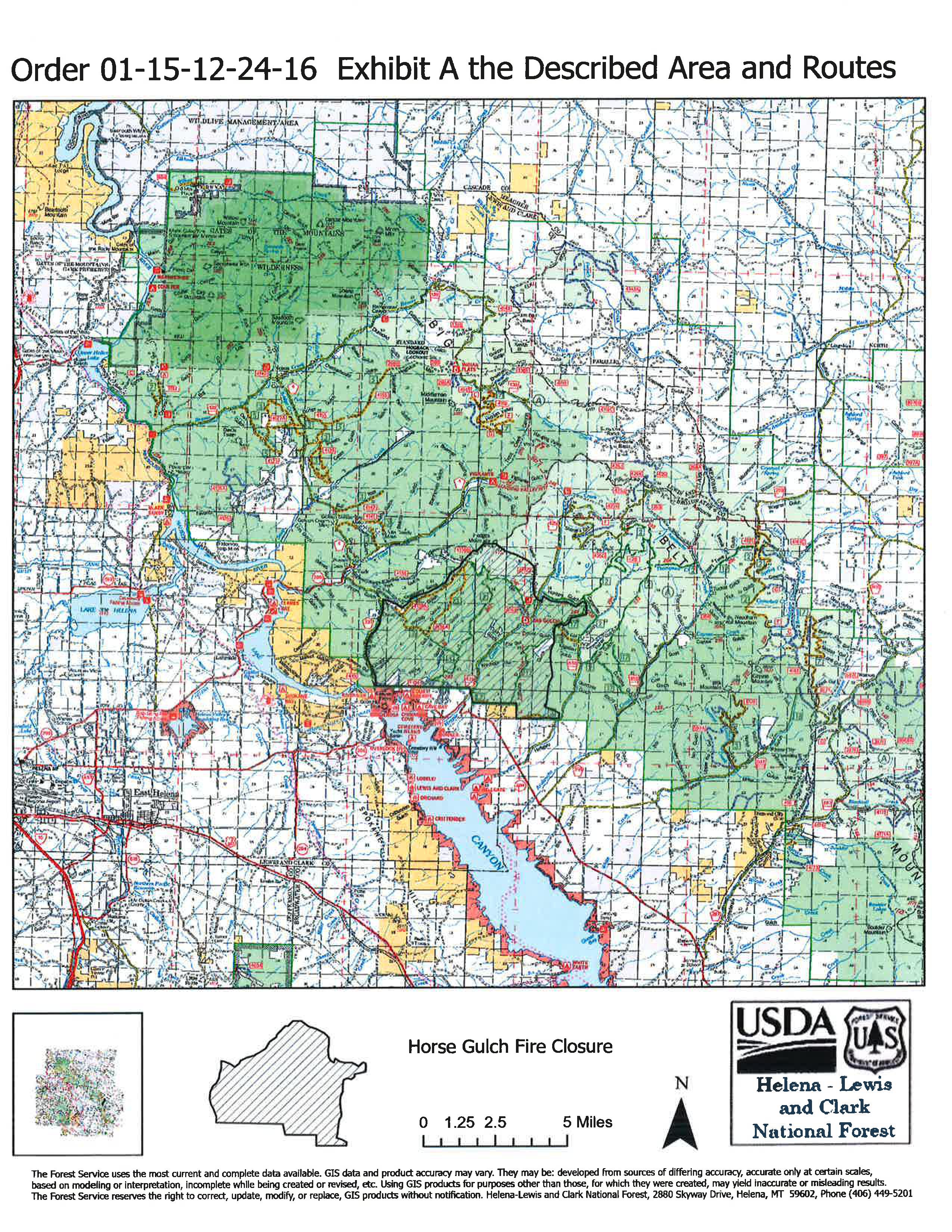
Signed Closure Order Horse Gulch Fire 7262024 07 26 2024
Related Incident: Horse Gulch Fire
Publication Type: Closures
Order Number: # 01-15-12-24-16
U.S. Department of Agriculture, U.S. Forest Service Helena-Lewis and Clark National Forest Helena and Townsend Ranger Districts
Area/Road/Trail Closure - Horse Gulch Fire
Badland Complex Information in the community 07 26 2024
Related Incident: Badland Complex 2024
Publication Type: Announcement
While you're out and about in Baker City, you may see fire information boards placed at some of your favorite businesses. You may also see one of our Public Information Officers posting updated information. Please feel free to stop and ask questions!
Information is being shared with staff or posted on info boards at the following locations:
- Albertson's
- Baker County Tourism/Chamber of Commerce
- Bi-Mart
- Safeway
- Dollar Tree
- Baker County Library
- Baker City Post Office
- Love's Truck Stop
- Truck Corral
- Oregon Trail Livestock Supply
- D&B Supply
Red Fire Daily Update 7262024 7262024 07 26 2024
Related Incident: Red Fire
Publication Type: News
Red Fire
July 26, 2024
Daily Fire Update
Online: https://inciweb.wildfire.gov/incident-information/ordef-red-fire
** NEW ** Facebook – 2024 Red Fire Information
** NEW ** Fire Information Line: 541-208-1766, 8:00 AM – 8:00 PM
Email: 2024.red@firenet.gov
Red Fire Quick Facts
Size: 389 acres Origin: 5 miles west of Crescent Lake Junction, Oregon County: Klamath
Start Date: July 17, 2024 Cause: Lightning Containment: 0% Total Personnel: 179
Today’s Highlight: The Eastern Area Complex Incident Management Team (CIMT), led by Brian Jenkins, Incident Commander, assumed the management of the Red, Round and Wickiup fires at 6:00 a.m. on July 26, 2024. The Eastern Area CIMT expresses appreciation to the Southern Area Gray Team for their support to the firefighters, community, and Deschutes National Forest.
Operations: Firefighters continued to assess feasible locations for construction of control features in the vicinity of the Red Fire within the Diamond Peak Wilderness. Hand crews also continued work to manually reduce wildfire fuels near Crescent Lake along Forest Service Road 60 in the vicinity of recreational residences. To the southeast of the fire, outside the Wilderness, a task force, consisting of heavy equipment continued construction of a shaded fuel break along the Union Pacific Railroad tracks.
Shaded fuel breaks consist of an area along a road or rail line, where dense tree stand are thinned to reduce fire intensity while retaining enough shade to slow down ground fire. Decreasing tree density minimizes the potential for fire to spread through the crowns of trees. Shaded fuel breaks are a fundamental tool to manage wildfire risk in fire prone environments.
Today, firefighters will continue to monitor the fire within the Diamond Peak Wilderness and identify access routes suitable for fireline construction. Hand crews, engines, and heavy equipment will continue to construct the shaded fuel break along the west side of the Union Pacific Railroad tracks and on the north side of Forest Service Road 60 southwest of the community of Crescent Lake Junction. Staff will continue to look for suitable routes that will allow them to extend this fuel break to the north.
Round Fire – Firefighters continue to work on mop up. The fire remains 108 acres and is 50 percent contained.
Wickiup Fire – Firefighters continue to work on mop up. The fire remains 168 acres and is 75 percent contained.
Closures – The Deschutes National Forest has implemented an emergency closure around Crescent Lake and in the Diamond Peak Wilderness. Closure information is available at: https://www.fs.usda.gov/alerts/deschutes/alerts- notices/?aid=89091
Evacuation Notices – The WILDFIRE! Level 1 – BE READY to Evacuate notice issued by Klamath County Emergency Management for the Crescent Lake, Odell Lake, and Crescent Junction area remains in effect (INCENDIO FORESTAL! Nivel 1 - ESTÉ PREPARADO para evacuar de las siguientes zonas: Crescent Lake, Odell Lake, Crescent Junction). For information, or to sign up for alerts, visit: www.klamathcounty.org/300/emergency-management
Fire Restrictions – Stage 2 Public Use Fire Restrictions which prohibit open fires, including in developed campgrounds, are in effect for the Deschutes National Forest. Visit the Deschutes National Forest’s website fs.usda.gov/detail/deschutes/home/?cid=stelprdb5297376 for more information. The Industrial Fire Precaution Level is currently Level IV “General Shutdown”.
Weather: Today, warmer, drier conditions are forecast with highs near 86 degrees. Widespread haze will cover the area in the morning followed by areas of smoke throughout the afternoon. Fire weather will continue to be moderate. Light winds out of the east will shift to west - northwest winds gusting to 15 mph in the afternoon. Relative humidity will be between 25 and 29 percent.
A Temporary Flight Restriction (TFR) is in place over the fire area. If you fly, we can’t! Unauthorized drone flights pose serious risks to firefighter and public safety and will halt aerial operations and seriously impact fire suppression efforts.
Smoke: Smoke from the Red Fire and other area fires will continue to impact air quality. Air quality information can be found at https://fire.airnow.gov/.
Actualizacin del incendio Easy 26 de julio de 2024 07 26 2024
Related Incident: Easy Fire
Publication Type: News
Actualización del incendio Easy
26 de julio de 2024
Datos clave
Tamaño: 410 acres
Fecha de inicio: 17 de julio de 2024
Ubicación: 17 millas al oeste de Mazama, WA
Contención: 0%
Personal asignado: 120
Causa: Rayos
Recursos asignados: 2 cuadrillas, 5 camiones de bomberos
SITUACIÓN ACTUAL: El incendio Easy arde entre árboles grandes y densos, muchos árboles muertos y vegetación de suelo en un terreno muy escarpado. Se ha moderado la actividad del fuego cerca de la carretera estatal 20 y ha habido una actividad continua dentro de la huella del incendio en el extremo norte y sur del incendio. El miércoles y jueves los bomberos trabajaron con el Departamento de transporte de Washington (WSDOT) para remover los escombros y los árboles caídos de la carretera. Se reevalúa regularmente el cierre de la carretera regularmente, así que asegúrese de consultar el mapa de viajes del WSDOT para obtener actualizaciones a lo largo del día.
Ayer, los bomberos continuaron preparando líneas de mano indirectas, conectándolas a rasgos naturales como toboganes de avalanchas y huellas de incendios anteriores. Como parte de los preparativos del cortafuego, las cuadrillas están instalando mangueras y sistemas de rociadores tanto en el extremo sur como en el norte. Además, establecieron con éxito helipuntos en el lado norte del incendio que permitirán un acceso adicional en caso de emergencia.
ACTIVIDADES DE HOY: Las cuadrillas continuarán trabajando con el Departamento de transporte de Washington para remover árboles caídos y los escombros de los lados de la carretera 20. También continuarán preparando la línea y el trabajo de talar en el extremo norte y sur del incendio Easy. Las cuadrillas están buscando oportunidades para realizar operaciones de quema estratégicas y así quemar la vegetación entre el incendio y el cortafuego construido. También están desarrollando un plan de operaciones aéreas para proteger las estructuras en la torre Mebee Lookout Tower si se requieren tales medidas por causa del fuego.
CLIMA: Las temperaturas hoy aumentarán un poco con máximas entre los 85 a 89 grados. Se espera que la humedad se modere hoy y el fin de semana. Disminuirán los vientos hoy con una dirección noroeste alrededor de 7 mph. La tendencia de enfriamiento continuará el fin de semana junto con menores vientos.
CIERRES: La carretera estatal 20 está cerrada actualmente como resultado de la actividad de fuego y escombros en la carretera. Hoy se reevaluará este cierre para ver si hay posibilidades en que se puede abrir parcialmente o totalmente la carretera. Asegúrese de consultar https://wsdot.com/Travel/Real-time/Map/ para obtener la información más reciente sobre el estado de cierre de la carretera.
El Bosque Nacional Okanogan-Wenatchee tiene órdenes de cierre en los senderos dentro del área afectada por el incendio: https://bit.ly/EasyFireClosures. Este cierre incluye una parte del sendero Pacific Crest Trail. Las fogatas están prohibidas. Hay una restricción temporal de vuelo (TFR, en inglés) sobre el área del incendio: https://tfr.faa.gov/save_pages/detail_4_6779.html. La actividad de drones no autorizados está prohibida por la TFR.
EVACUACIONES: No existen órdenes de evacuación para el incendio Easy. Cualquiera que utilice la zona para recrearse debe estar atento a su entorno y permanecer fuera de las áreas cerradas.
InciWeb: https://inciweb.wildfire.gov/incident-information/waowf-easy-fire
Facebook: https://www.facebook.com/profile.php?id=61560760893080
Línea de información sobre el incendio: 541-861-5808, de 8 AM a 8 PM
Correo electrónico: 2024.pioneer@firenet.gov
Big Horn Fire Daily Update 07 26 2024
Related Incident: Big Horn Fire
Publication Type: News
Big Horn Fire
11:00 AM, July 26, 2024
Estimated size: 49,063 acres
Containment: 21%
Start Date/Time: 7/22/2024 at 1:07 PM
Area of Origin: 7 miles SE of Bickleton, WA
Cause: Undetermined
Structures Damaged: 4
Update: Overnight crews worked to establish a stronger fire perimeter and monitor areas of concern. With cooler temperatures and reduced winds, the fire stayed within the existing boundaries.
Additional resources have arrived and are aiding the suppression efforts. Today’s weather brings lower temperatures, lower winds and an increase in relative humidity. All of which work together to reduce the fire’s growth potential. These favorable conditions will assist the firefighters as they continue to improve existing control lines around the fire.
For today’s shift, firefighters will be concentrating on improving and installing additional control lines in all divisions of the fire. Work will also focus on mitigating any safety hazards or impacts to the public. Night shift operations will continue tonight.
Evacuation Levels: Evacuation levels remain in effect. Please visit Klickitat County Emergency Management’s website or check Facebook:
Road Closures: East Road is closed from the Town of Bickleton south to Middle Road. Hwy 14 from the Town of Roosevelt to Alderdale Road. Alderdale Road from Linda Lane south to the intersection with SR 14.
Weather and Fire Behavior: Cooler temperatures and lower winds last night and into today. Warm and dry conditions continue with wind gusts around 10 mph.
Smoke: Satellite imagery this morning shows large swaths of smoke across the region. With the large number of fires in the Pacific NW and continued westerly flow, smoke impacts should be expected in central and eastern Washington through the weekend. New Air Quality Alerts are in place for Klickitat, Benton, Walla Walla, Columbia, Garfield, and Asotin counties. If you are near fire locations, please stay up to date on evacuation orders.
While there are no current air quality alerts for Klickitat County, communities close to active wildfires could see air quality worsen as the fire and wind conditions change. Critical fire weather continues across Central and Eastern Washington; please continue to recreate responsibly as any fire starts could spread quickly. For more information on smoke and air quality, please visit: Washington Smoke Information (wasmoke.blogspot.com)
Shelter: An American Red Cross Shelter has been opened in neighboring Benton County and is currently assisting individuals and families that are displaced by the fire.
Patterson Elementary School
51409 Prior Ave
Patterson, WA 99345
Resources: Multiple overhead, strikes teams, aircraft and dozers are currently responding to the fire.
###
Actualizacin diaria del incendio Pioneer 26 de julio de 2024 07 26 2024
Related Incident:
Publication Type: News
Actualización diaria del incendio Pioneer
26 de julio de 2024
Tamaño: 31,906 acres
Fecha de inicio: 8 de junio de 2024
Ubicación: 31 millas al NO de Chelan, WA
Contención: 14%
Personal: 766
Causa:De origen humano, a ser determinada
Recursos asignados: 12 cuadrillas, 5 helicópteros, 24 camiones de bomberos, 28 tanques de agua, 12 maquinarias pesadas
SITUACIÓN ACTUAL: Ayer la actividad del fuego se moderó a lo largo de la orilla del lago y los helicópteros vertieron agua para minimizar más la propagación del fuego. Las cuadrillas continuaron el trabajo de fuego estratégico alrededor de casas y dependencias alrededor de DP 17 cerca de Flick Creek y patrullaron el área para asegurarse de que no quedaran rastros calor por las operaciones de quema anteriores. En Stehekin, los bomberos continuaron mejorando el cortafuego alrededor del pueblo y trabajaron junto con los recursos movilizados del estado, e instalaron un sistema de rociadores y lo pusieron a prueba. El extremo sur del incendio sigue en su lugar en Lone Fir Creek y las cuadrillas trabajaron en las líneas de contingencia indirecta al sur del incendio.
La logística en el incendio Pioneer requiere un nivel adicional de coordinación debido a las comunidades remotas y el acceso. Los bomberos en las zonas de incendio del norte y la orilla del lago están siendo apoyados por barcos que los llevan al área del incendio y llevan provisiones para combatir el fuego. Además, la gestión del incendio está trabajando con empresas locales en Stehekin para proporcionar comidas y otros apoyos a las cuadrillas que trabajan en esa área.
ACTIVIDADES DE HOY: Hoy continuará el trabajo de extinción y contención por todo el incendio Pioneer. A lo largo del perímetro noroeste del incendio, los bomberos se están preparando para llevar a cabo el trabajo de quema estratégica adicional para quemar la vegetación entre la línea y el fuego activo. Los drones pudieran ser utilizados en este trabajo y los bomberos trabajarán por la noche para patrullar el área y apoyar posibles operaciones de quema. Los helicópteros brindarán agua para enfriar el fuego y limitar su propagación. En Stehekin, los equipos de bomberos continuarán mejorando el cortafuego construido alrededor de la comunidad y coordinando con el grupo de protección de estructuras movilizadas del estado que está trabajando alrededor de casas y propiedades privadas. Al sur, las cuadrillas estarán mejorando las carreteras cerca de Gold Creek y Oss Peak.
CLIMA: Regresarán hoy condiciones más caliente y secas, con temperaturas máximas a los 85 grados. Mañana los vientos serán más ligeros y mayormente impulsados por el terreno, y cambiarán lago abajo o al noroeste por la noche.
EVACUACIONES: Los niveles 1, 2 y 3 de evacuación alrededor del incendio Pioneer no han cambiado. Visite https://t.ly/QoH9w para tener más información.
CIERRE DEL BOSQUE: Cierres vigentes del Parque nacional North Cascades: https://www.nps.gov/noca/index.htm
El Bosque Nacional Okanogan-Wenatchee ha emitido una orden de cierre sobre gran parte del área afectada por el incendio: https://bit.ly/PioneerClosure. Las fogatas están prohibidas. Hay una restricción temporal de vuelo (TFR, en inglés) sobre el área del incendio: https://tfr.faa.gov/save_pages/detail_4_6779.html. La actividad de drones no autorizados está prohibida por la TFR.
InciWeb: https://inciweb.wildfire.gov/incident-information/wases-pioneer
Facebook: https://www.facebook.com/profile.php?id=61560760893080
Línea de información sobre el incendio: 541-861-5808, de 8 AM a 8 PM
Correo electrónico: 2024.pioneer@firenet.gov
Bridge Creek Daily Update July 262024 07 26 2004
Related Incident: Bridge Creek
Publication Type: News
Update for Swawilla and Bridge Creek Fires
• Evacuation areas remain at a Level 3 around the Swawilla Fire.
• Highway 155 remains open. See chart for closures.
See Inciweb Site for locations and evacuation boundaries.
The Incident Team will host a community meeting on Friday, July 26 at 7pm at the Nespelem Head Start Center, 19 Wenatchi St.
Swawilla Fire
FIRE ACTIVITY: Fortunately, Thursday’s forecast winds were not as strong as predicted and the fire was less active than feared. High temperatures and low humidity did allow it to grow, just more modestly. More seasonable weather with a lighter west/southwest wind should be around through the weekend. The line along the Swawilla Basin, at the heel of the fire, is considered contained. Along the Peter Dan Road, firefighters were able to do point protection around structures and were supported by retardant drops. The fire made one attempt to cross the Peter Dan road and was stopped by a Type 1 hot shot crew. On the other side of the fire, flames pushed against the lower Manilla Road but did not cross it. Fire moved into some of the drainages southwest of Keller and made its way to the top of Mt.Tolman. It is now backing down the north side towards Meadow Creek. Fuels on this side of the mountain are greener, slowing progression.
The priority of fire management continues to be life and structure protection, however the incoming, more moderate weather after the cold front, provides a good opportunity for more direct attack on the fire. Crews are scouting for terrain features, such as old roads and dozer lines, to continue containment line efforts to reduce further spread to the east.
More resources are showing up daily and some are able to shift from the Bridge Creek Fire to support actions on the Swawilla Fire. A night shift and a swing shift are in place allowing for around-the-clock work on the line. These firefighters, engines, machinery and firefighting infrastructure require more space to house so the Forward Operating Base (FOB) has moved from Keller to a 20 acre camp near the intersection of Agency Cutoff Road and Cache Creek Road. The Incident Command Post remains at the Nespelem Community Center.
Even with the favorable change in the weather, forecasting models still indicate a chance that the fire will reach the town of Keller, push towards the Cache Creek Road, and impact the Buffalo Lake area. For this reason, evacuations remain in place. Community leaders are regularly evaluating these orders with the incident management team. The team appreciates the community’s patience with this process.
An evacuation center is open at the Lake Roosevelt High School gym in Coulee Dam. The shelter at the Paschal Sherman Indian School in Omak is full. Keller Ferry is open only for limited service to assist with evacuations.
Bridge Creek Fire
The Bridge Creek Fire is looking good. Firefighters are monitoring the line and working to extinguish hot spots on the east side of the fire. Opening the Bridge Creek Road is a priority and crews are focusing significant time in removing fire weakened trees that may fall on Bridge Creek Road and threaten the safety of the public when the road opens.
Diamond Complex QA session July 27 1030am at Diamond Lake Resort 07 26 2024
Related Incident:
Publication Type: Announcement
Diamond Complex fire managers will host a question-and-answer session on Saturday July 27th, at 10:30am at the Diamond Lake Resort. Fire staff will be on hand to answer community questions. Diamond Lake Resort is located at 350 Resort Drive, Diamond Lake, OR 97731