
Diamond Complex Daily Update 07 26 2024
Related Incident:
Publication Type: News
July 26, 2024
**Diamond Complex Q & A session at Diamond Lake Resort, 10:30 am, Saturday July 27, 2024. Fire staff on hand to answer community questions.**
A large-scale lightning event on July 16 started several fires on the Diamond Lake Ranger District of the Umpqua National Forest. The fires are being managed as the Diamond Complex. It consists of 24 fires and an estimated 4,166 acres with 3% containment and 395 personnel assigned.
Nationally and in the Pacific Northwest, fire activity is putting an extreme demand on firefighting resources. The highest priority remains public and firefighter safety and protecting infrastructure and homes.
The fires are being managed under a full suppression strategy. This means that crews engage in direct attack on the fires’ edge where access and firefighter safety allow. They are implementing indirect strategies using constructed control lines and utilizing natural barriers where direct attack cannot be done safely. Pacific Power and Light (PP&L) infrastructure within the complex continues to be a top priority for protection as crew attack fires threatening those resources.
The Trail fire, east of Hwy 138 on the west slope of Mt. Thielsen, is 830 acres and 5% contained. Crews continue to keep the fire within the current control lines and minimize impacts to the recreational values around Diamond Lake.
The Lemolo fire, north of Lemolo Lake on Bunker Hill, is 627 acres and 0% contained. Crews will continue to complete dozer line on the east flank and look for opportunities to implement control lines north of the fire to protect recreational values around Lemolo Lake.
The Pine Bench fire, north of Hwy 138 near Dry Creek, is 1,546 acres and 0% contained. Crew will patrol and continue to hold the 4775 road and hold and mop up any new spot fires.
Watson fire, north of Hwy 138 on Watson Ridge fire is 166 acres and 0% contained and the Loafer fire at 24 acres and 0% contained. Crews have been making great progress with the limited resources available. They will begin direct line construction and hose lay today and continue to fortify lines.
There are smaller clusters of fires within the complex that consist of: Pig Iron, 27 acres and 25% contained, near Pig Iron Mountain north of Hwy 138; Brodie, 98 acres and 0% contained, about 5 miles south of Hwy 138 and south of Devils Canyon; Trep, 109 acres and 0% contained, about 4 miles south of Hwy 138; Garwood, 5 acres and 65% contained, about 3 miles southwest of Mt. Bailey; Slide, 0.1 acres and 90% contained, northeast of Pine Bench; Potter, 504 acres and 0% contained, north of Hwy 138 about 2 miles southeast of Potter Mt.; Ooya, 136 acres and 0% contained, north of Hwy 138 about 1 mile northeast of Bird Point; Clearwater, 1 acre and 90% contained, south of Hwy 138 about 5 miles northwest of Diamond Lake; Elephant, 0.7 acres and 0% contained, 2 miles southwest of Lemolo Lake; Lost Bear, 5 acres and 0% contained, 2 miles south of Hwy 138; Lost, 14 acres and 0% contained, 4 miles south of Hwy 138; Sheep, 0.3 acres and 0% contained, 3 miles north of Diamond Lake; Thin, 1 acre and 0% contained, four miles northwest of Diamond Lake; Trap, 4 acres and 0% contained, 1 mile south of Hwy 138 near Trap Mountain; Bear Trap, 45 acres and 0% contained, 2 miles south of Hwy 138 near Bear Trap Mountain; Campwood, 8 acres and 0% contained, 2 miles south of Hwy 138; Rough, 8 acres and 0% contained, two miles south of Hwy 138, Birds, 10 acres and 0% contained, Wood, 2 acres and 0% contains, 2 miles south of Hwy 138; and Mowich, 1 acre and 0% contained, 1 mile north of Hwy 138.
Today, firefighters will continue direct suppression on accessible fires, and will develop specific suppression strategies for other less accessible fires to be carried out as resources become available.
Weather: Today will be slightly cooler with higher humidity and lighter winds. While these conditions favor firefighting, very dry forest fuels and steep terrain will still allow persistent fire spread.
Fire Behavior: Fire will likely remain active especially as temperatures increase into the afternoon hours. Short uphill runs are through surface fuels and some torching potential remains in areas with heavier fuel loads.
Smoke Outlook: Smoke continues to impact the region. For the most up to date information, please visit www.fire.airnow.gov
Closures and Evacuations: Umpqua National Forest has issued two closures across the forest in response to fire activity to protect public and wildland firefighter safety. Emergency Fire Closure ORDER NO. 06-15-24-03 and Emergency Fire Closure ORDER NO. 06-15-02-24-01 which impact all of the Cottage Grove Ranger District, most of the Diamond Lake Ranger District, and parts of the Tiller and North Umpqua Ranger Districts. The closure orders can be found here: https://www.fs.usda.gov/alerts/umpqua/alerts-notices. Additionally, Diamond Lake, Thielsen View, and Broken Arrow Campgrounds are closed through July 28, 2024, and will be reevaluated closer to that date. Fire danger is set at High and Public Use Restrictions are set at Level 2: https://bit.ly/3xIZZdK.
Douglas County Sheriff has issued a Level 3: GO NOW and Level 2: BE SET for the Trail Fire and Lemolo Fire. There is a Level 2: BE SET for the Pine Bench Fire. Please see detailed information here: www.dcso.com/evacuations.
Tanques Wildfire Closure Order 0310022411 07 26 2024
Related Incident: Tanques Wildfire
Publication Type: Closures
TEMPORARY AREA AND ROADS CLOSURE FOR THE TANQUES WILDFIRE
Prohibited/Not Allowed
The following are prohibited on the National Forest System (NFS) lands and roads in the Cuba Ranger District, Santa Fe National Forest:
- Going into or being upon an area. 36 C.F.R. § 261 .53 (e).
- Using any motor vehicle on the roads(s) described below. 36 C.F.R. § 261 .54(a).
Review the closure order for any exemptions.
Described Area (Prohibited/Closed Area and Roads)
Roads:
- The described roads include FR313 from the junction of FR313 and FR517 to the junction of FR313 and FR515.
- FR515 from the junction of FR515 and FR313 to the junction of FR515 and FR514J.
- FR514J from the junction of FR514J and FR515 to FR514. FR514 from the junction of FR514J and FR514 to the junction of FR514 and FR517.
- FR517 from the junction of FR517 and FR514 to the junction of FR517 and FR313.
Lands:
- All National Forest Service lands within the described area which starts at the junction of Forest Roads 513 and 515.
- It follows FR 513 northwest to the junction of FR 517.
- It follows FR 517 south to the junction of FR 514, then follows FR 514 east to the junction with FR 514J.
- It follows FR 514J east to the junction of FR 515, then follows FR 515 back to the junction with FR 313.
Purpose: Protecting Public Safety
The purpose of this Order is to protect the public's health and safety during the firefighting operations for the Tanques Wildfire.
Effective Dates
This Order shall be in effect from July 26, 2024, at 8 a.m. through August 31, 2024, at 12 a.m., unless rescinded.For More Information
For More Information
- Cuba Ranger District Office in Cuba, NM, (575) 289-3264
- Santa Fe National Forest Supevisor's Office in Santa Fe, (505) 438-5300
Oakridge Lightning Fires 2024 Daily Update Friday 07 26 2024
Related Incident: Willamette Complex Fires - South
Publication Type: News
Fire Update – Oakridge Lightning Fires
Chalk, Coffeepot, McKinley, Moss Mountain, Tire Mountain, 208, and 217 Fires
Friday, July 26, 2024 – 9:00 a.m.
Rocky Mountain Complex Incident Management Team 1
Dan Dallas, Incident Commander
Information Phone: (541) 208-1742
Email: 2024.mossmountain@firenet.gov
Information Staffing Hours: 8 a.m. to 8 p.m.
Special Note: A community meeting will be held this evening at 6:00 p.m. in the auditorium of the Oakridge High School, 47997 W 1st St. Oakridge, OR. Fire managers and local officials will provide the latest updates on fire activity and suppression efforts. Parking at the high school is limited, please plan accordingly.
Current Situation: Oakridge Lightning fires continue to grow with low to moderate spread. Firefighters are making good progress with limited available resources as they continue to build and strengthen line in areas of highest concern. Priority fires remain the Chalk, Coffeepot, Moss Mountain, and 208 fires. The McKinley, Tire Mountain, and 217 fires are showing minimal activity and are not posing an immediate threat to valued resources. The total acreage of the seven fires is 5,027 acres with 583 personnel assigned.
Information for the seven fires making up the Oakridge Lightning Fire group is provided below. Each fire is divided into lettered divisions, for better management and safer operations. Firefighting activities and suppression actions are provided in detail for each division. Note that Division letters do not always run sequentially so that new Divisions may be added if the fire grows.
Chalk Fire (2,916 acres, 0% contained) – Crews continue to build and secure line to hold the fire as well as to provide additional options for future strategic containment operations. Expect to see increased smoke as work progress on this fire.
Division AA: Firefighters continue to take aggressive suppression action on the southern part of the Chalk Fire to protect the communities of Oakridge and Westfir. These actions include low to moderate intensity firing operations and constructing fire line with bulldozers and other heavy equipment.
Division KK: Crews prepared for a possible firing operation later today with favorable conditions. The firing operation will tie in previous prep work to strengthen containment line on the southern part of the Chalk Fire.
Division TT: A small low-intensity firing operation is being prepared for north side of the Chalk Fire to secure options for tying in this area of the fire with the 2021 Gales Fire footprint.
Coffeepot Fire (1,687acres, 0% contained) – The Coffeepot Fire gained approximately 375 acres yesterday due to receptive heavy fuels located in rugged terrain aligned with prevailing northwesterly winds.
Division PP: Crews working on the southern part of the Coffeepot Fire are constructing and preparing line to secure the fire north of privately held land, protecting those values at risk.
Division RR: Heavy equipment and hand crews are working to build new line and strengthen existing line on the north side of the Coffeepot Fire. Work continues to tie in this section of the fire with Division WW, providing for future strategic operations.
Division WW: Prep work continues in this division to build line and scout for areas where firefighters will have a high probability of success in holding the Coffeepot Fire west of Hills Creek.
Moss Mountain Fire (201 acres, 0% contained) –Steep, rugged terrain continues to make access the Moss Mountain Fire difficult to access. Fire growth was minimal yesterday.
Division SS: This new division was created to scout and place resources where there is a high probability of success.
Division WW: Crews working in this division are preparing line and scouting for future options.
208 Fire (138 acres, 0% contained) – Division YY: Aerial imaging gathered yesterday confirmed that the 208 Fire is burning in fuels mostly surrounded by rocky terrain, with little chance of spread under current and forecasted wind conditions.
217 Fire (38 acres, 0% contained) – Division YY: This fire gained one acre yesterday. There is some threat for the fire to spread north of the Wilderness boundary. Smokejumpers continue their work of securing line and mopping up.
Tire Mountain Fire (20 acres) – Division TT: Fireline completed, minimal activity yesterday as the fire backed toward containment lines. Crews will continue to patrol this fire; some will be reassigned to higher priority divisions.
McKinley Fire (27 acres) – Division AA: Fireline completed, crews continue to mop up and secure fireline as they work toward full containment. Crews will continue to patrol this fire; some will be reassigned to higher priority divisions.
Weather and Fire Behavior:
Smoke settled in across the Oakridge Lightning Fires this morning, which will lessen fire activity until the afternoon, when the smoke lifts and the sun provides receptive fuel more energy to burn at greater intensity. Temperatures will remain in the 70-80s with relative humidity hovering around 30-42%. Expect to see an increase in activity between 12:00 p.m. to 2:00 p.m.
Evacuations:
For evacuation information please visit: https://www.LaneCountyOR.gov/2024wildfires
To sign up for evacuation alerts please visit: https://www.LaneAlerts.org
Closures and Fire Restrictions:
Area, road, trail, and recreation site closures are in place on the Willamette National Forest in the vicinity of many active fires. Temporary road barricades are in use to restrict traffic in the areas near High Prairie and Chalk Mountain.
For specific closure information follow this link:
https://www.fs.usda.gov/detail/willamette/alerts-notices/?cid=fseprd552029
Fire restrictions on the Willamette National Forest may be found at this link: https://www.fs.usda.gov/alerts/willamette/alerts-notices/?aid=81487
Wildfires are a no-fly zone for unauthorized aircraft, including drones. If you fly, we can’t. For more information, visit http://knowbeforeyoufly.org.
Fire Statistics
Total Personnel: 583
Location: N & S of Oakridge, OR
Cause: Lightning
For More Information
Information Phone: (541) 208-1742
Email: 2024.mossmountain@firenet.gov
InciWeb: https://inciweb.wildfire.gov/incident-information/orwif-oakridge-lightning-fires-2024
Facebook: https://www.facebook.com/OakridgeLightningFires2024/
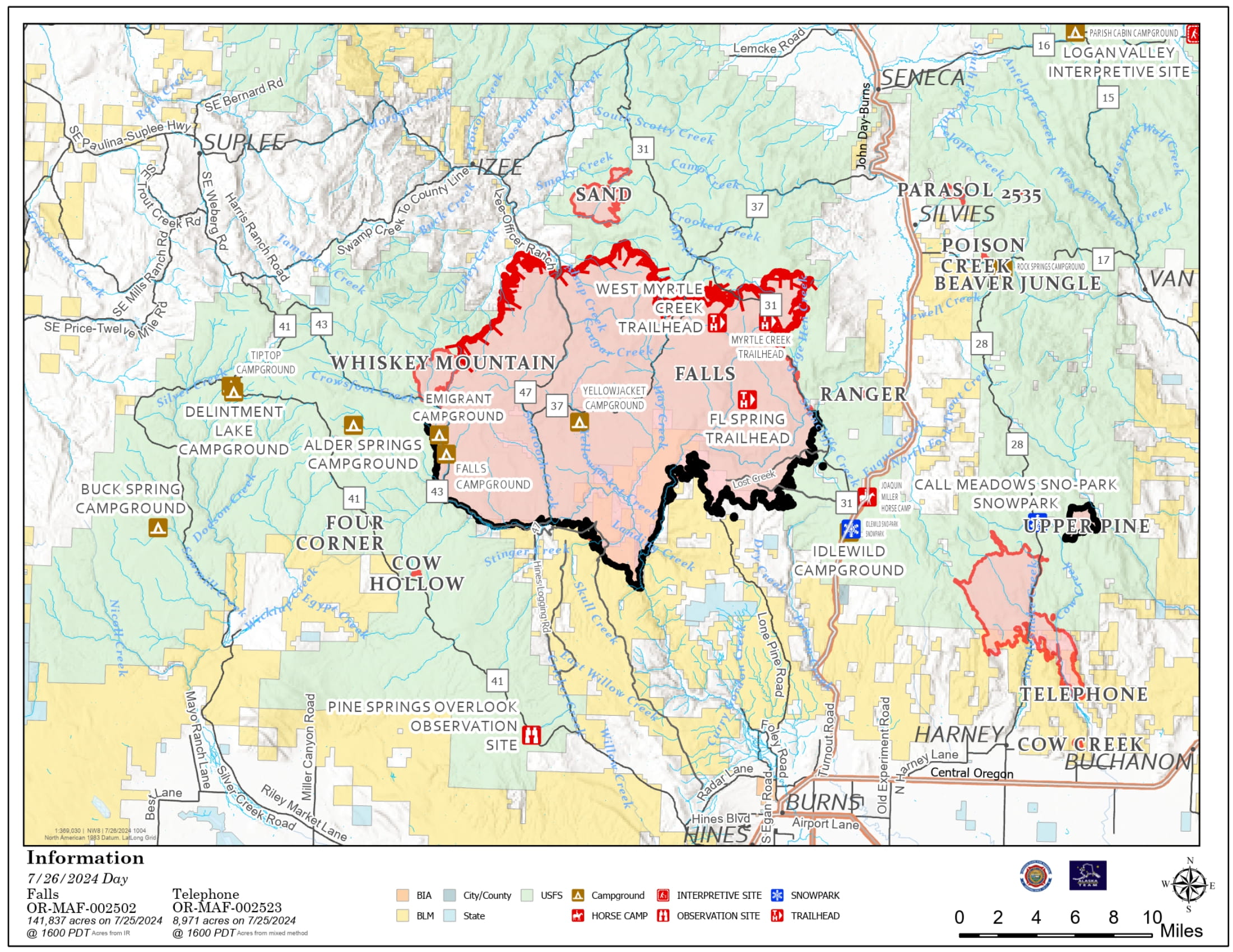
Falls and Telephone Fires Update 07 26 2024
Related Incident: Falls FireTelephone Fire
Publication Type: News
Falls and Telephone Fires Update for July 26, 2024
Falls Fire Quick Facts:
Size: 141,927 Start Date: July 10, 2024 Location: 13 Miles NW of Burns, OR
Containment: 55% Total Personnel: 1,558 Cause: Human-caused, under investigation
Structures Triaged: Residences: 377; Commercial: 118 Outbuildings: 677
Resources Assigned: 38 hand crews, 79 engines, 24 bulldozers, 25 water tenders
Aerial resources available to the fire: two helicopters, and single-engine air tankers (SEATS)
Telephone Fire Quick Facts:
Size: 12,180 Start Date: July 22, 2024 Location: 12 miles NE of Burns, OR
Containment: 0% Total Personnel: Staffed by Falls Fire personnel Cause: Lightning/Natural
New Fire Activity Quick Facts:
Whiskey Mountain: 2,565 acres; Cow Creek: 85 acres; Sand: 2,733 acres; Parasol: 353 acres; Poison: 39.6
Alaska Complex Incident Management Team 1 assumed command of Falls and Telephone Fires at 6:00 am Friday morning and remains in Unified Command with Oregon State Fire Marshal (OSFM).
Thursday afternoon, strong afternoon winds coupled with extremely dry fuels increased fire behavior on the Telephone Fire. Several new fire starts were located to the east of Falls Fire in the Parasol Butte area. Evacuation levels were issued and extended due to the new starts and Telephone Fire’s move across FSR28.
Crews assigned to the Falls Fire responded to new starts and the expanding Telephone Fire, along with aerial resources, to minimize the impact of fire growth. Structure protection crews quickly mobilized and also responded to the area. Telephone Fire has grown 3,000 acres and moved further to the southeast overnight and is approximately 4 miles north of Hwy 20.
Falls Fire: On Thursday, control lines continued to hold in areas where homes were previously threatened, including the Red Hill area and the Izee community. Prep has been completed by wildland and structure crews within the area directly adjacent to the Sand Fire, where the fire is steadily moving away from structures. This allowed OSFM assets to shift to the Telephone Fire, as fire activity moved to the northeast. Structural assets also continue to patrol the Highway 395 corridor, protecting properties to both the east and west. Structure crews responded alongside wildland resources to the Parasol Butte area to address structural protection related to multiple new fires in the area. This work continued overnight, with crews identifying structures and evaluating protection needs.
Crews on the southern and western perimeter continued to reinforce control line and mopped up additional hot spots. On the western side, firefighters conducted burn operations to tie the Whiskey Mountain Fire into the Falls Fire. Fire crews utilized direct attack and firing operations to protect resources to the west, including Izee. To the northwest, firefighters worked to tie together portions of control line using dozers and hand crews. On the northeast side, crews advanced fireline on the FSR31, moving west along Lonesome Creek with the assistance of heavy equipment. On the eastern edge, work progressed along FSR31, with fuel removal and mop up.
Today, crews will continue to mop up and hold areas on the south end of the Falls Fire. To the west, direct and indirect firing tactics will be used to tie Whiskey Mountain Fire into the Falls Fire and existing road lines.
Telephone Fire: On Thursday, the fire experienced significant growth to the south and southeast and crossed FSR28 and Military Road. The fire has crossed Cow Creek, as well as Little Cow Creek. Crews remained engaged in suppression efforts and worked alongside night shift for several hours. The plan for Friday is to continue tying in firelines in the north and to look for opportunities to anchor the fire near FSR28.
Focus has shifted the structural resources north of Highway 20, throughout the Cow Creek area and continuing east. Overnight, OSFM assets assigned to the Telephone Fire continued to patrol the structures to the south and southeast of the fire area. Friday, crews will continue to identify, assess and begin to prep homes in the area affected by the updated level 3 evacuation zone. This work is being prioritized on homes directly adjacent to the fireline.
Although Thursday was another active day, the threat to structures does still continue to trend downward. As part of the structure risk reduction, the number of surveyed and prepped structures has increased. This means that the location of structures is mapped, ensuring crews will know the best access routes, should they become threatened. The prep work that has been completed ranges from surface to full prep, depending on proximity to the fire. These extensive efforts help mitigate the risk to structures should the fire front move through the area.
New Starts: There were multiple new fires reported Thursday inside the Falls and Telephone Fire Temporary Flight Restriction (TFR) area. Resources assigned to the Falls Fire engaged in initial attack (IA). The largest of these starts is the Parasol Fire, located near Parasol Butte. It is estimated at around 353 acres. An additional start located near Poison Creek, was approximately 40 acres. Resources from multiple locations from the Falls Fire were assigned to both new starts. Firefighters will remain on the Parasol and Poison fires Friday and will work direct on the fire’s edge where possible. Firefighters assigned to the fires around the Falls Fire will respond to any new starts.
The Sand Fire, which is burning near Sand Mountain north of the Falls Fire, was discovered yesterday. Air resources assisted ground forces with suppression efforts and made steady progress throughout the day. OSFM Task Forces provided structural protection. Crews took advantage of cooler night temperatures to conduct strategic firing operations, in conjunction with heavy equipment, to create control lines. OSFM crews will work to complete protection work on structures in the vicinity.
Weather: Smoky conditions will continue through the morning. An inversion layer sits over the fire and is expected to lift by early afternoon. Temperatures will remain slightly lower today and will stay in the mid-80’s. Skies will generally be clear by afternoon. Like Thursday, northwesterly winds will become westerly and breezier in the afternoon before returning to northeasterly. Gusty winds can be expected over the fire again later today.
Evacuations: Evacuations remain in place in both Grant and Harney Counties and have expanded to include Level 3 evacuations due to the Telephone, Parasol and Poison Fires. For the most accurate evacuation information, please visit the Harney County Sheriff’s evacuation map here: https://tinyurl.com/3zst4sjy, or the Grant County Emergency Management Facebook page at: https://www.facebook.com/profile.php?id=100068819321423.
Closures: Due to active wildfires compounded by extremely unfavorable weather conditions, limited firefighting resources and County Resources, Malheur National Forest officials have temporarily closed lands within the Malheur National Forest.
Investigation: U.S. Forest Service fire investigators are seeking the public’s assistance with any tips or information pertinent to the start of the Falls Fire on the Malheur National Forest. Please submit any information that could assist fire investigation efforts to SM.FS.R6TipHotLine@usda.gov.
Facebook: https://www.facebook.com/p/Falls-Fire-2024-61562126623985/
Falls Fire InciWeb: https://inciweb.wildfire.gov/incident-information/ormaf-falls-fire
Telephone Fire InciWeb: https://inciweb.wildfire.gov/incident-information/ormaf-telephone-fire
Fire Information Line: 541-208-4370, staffed 8 a.m. to 8 p.m.
Email: 2024.Falls@firenet.gov
Harney County non-emergency evacuation questions: 541-589-5579
Air quality questions: 541-573-2271
Smoke Outlooks: https://outlooks.airfire.org/outlook
Snake River Road BLM Closures 07 24 2024
Related Incident: Durkee Fire
Publication Type: Closures
Due to fire suppression activity, road closures and evacuation orders associated with the Badlands Complex Fires, all Vale District Bureau of Land Management recreation sites along the Snake River between Oxbow and Huntington, and on Lookout Mountain, are closed. This includes Spring Recreation Site, Swedes Landing and Bassar Diggins Campground.
Easy Fire Update 07 26 2024
Related Incident: Easy Fire
Publication Type: News
Easy Fire Update for July 26, 2024
Incident Commander Lonnie Click
Complex Incident Management Team Northwest 3
(541) 861-5808, staffed 8 a.m. to 8 p.m. 2024.pioneer@firenet.gov
Quick Facts
Size: 410 acres
Start Date: July 17, 20244
Location: 17 miles west of Mazama, WA
Containment: 0%
Personnel Assigned: 120
Cause: Lightning
Resources Assigned: 2 crews 5 engines
CURRENT SITUATION: The Easy Fire is burning in large dense timber, abundant dead trees, and ground vegetation on extremely steep terrain. Fire activity near State Route 20 has moderated with continued fire activity within the fire footprint on the north and south side of the fire. Firefighters worked with Washington Department of Transportation (WSDOT) on Wednesday and Thursday to clean up debris and fallen trees across the highway. The highway closure is regularly being reassessed, so please be sure to check the WSDOT travel map for any updates throughout the day.
Yesterday firefighters continued preparation of indirect handlines, tying into natural features like avalanche chutes and previous burn scars. As part of the fireline preparations crews are installing hoselays and sprinkler systems on both the south and north side of the fire. In addition, crews successfully established helispots on the north side of the fire which will provide additional access in case of an emergency.
TODAY’S ACTIVITIES: Crews will continue to work with Washington Department of Transportation to clean up fallen trees and debris from the shoulders of State Route 20. Firefighters will also maintain line preparation and falling operations on the north and south side of Easy Fire. Crews are scouting opportunities to conduct strategic firing operations to burn out vegetation between the fire and constructed fireline. Firefighters are also developing an aerial operations plan for structure protection on Mebee Lookout Tower if fire activity necessitates such measures.
WEATHER: Temperatures today will rise slightly with highs in the mid to upper 80s. Humidity is expected to moderate today and through the weekend. Winds will decrease today with a northwest direction around 7 mph. The cooling trend will continue over the weekend along with a reduction in winds.
CLOSURES: State Route 20 is currently closed due to fire activity and debris on the road. This closure is being reassessed today to see if there are opportunities for partial or full opening of the highway. Be sure to check https://wsdot.com/Travel/Real-time/Map/ for the latest information on the highway closure status.
The Okanogan-Wenatchee National Forest has closures in place for trails within the fire area: https://bit.ly/EasyFireClosures. This closure includes a portion of the Pacific Crest Trail. Campfires are prohibited. There is a Temporary Flight Restriction (TFR) in place over the fire: https://tfr.faa.gov/save_pages/detail_4_6779.html. Unauthorized drone activity is prohibited under the TFR.
EVACUATIONS: There are no evacuations in place for the Easy Fire. Anyone recreating in the area should be vigilant about being aware of surroundings and stay out of closed areas.
Facebook: https://www.facebook.com/profile.php?id=61560760893080
Fire Information Line: 541-861-5808, 8 AM to 8 PM
Email: 2024.easy@firenet.gov
Ahtanum State Forest Closure 07 24 2024
Related Incident: Retreat
Publication Type: Closures
The Washington State Department of Natural Resources (DNR) Southeast Region has temporarily closed the Ahtanum State Forest due to increased activity from the adjacent Retreat Fire burning near Rimrock Lake. The public can access the most up-to-date closure information at www.dnr.wa.gov/ahtanum.
Pioneer Fire Update 07 26 2024
Related Incident:
Publication Type: News
Pioneer Fire Update for July 26, 2024
Incident Commander Lonnie Click
Complex Incident Management Team Northwest 3
(541) 861-5808, staffed 8 a.m. to 8 p.m. 2024.pioneer@firenet.gov
Quick Facts
Size: 31,906 acres
Start Date: June 8, 2024
Location: 31 miles NW of Chelan, WA
Containment: 14%
Personnel: 766
Cause: Human-caused, under investigation
Resources Assigned: 12 crews, 5 helicopters, 24 engines, 28 water tenders, 12 heavy equipment
CURRENT SITUATION: Along the lakeshore, fire activity moderated yesterday, and helicopters dropped water to further slow fire spread. Crews continued strategic firing operations around homes and outbuildings around DP 17 near Flick Creek and patrolled the area to ensure no heat remained from previous firing operations. In Stehekin, firefighters continued to improve the fireline around the community, and working in coordination with state mobilized resources, put in a sprinkler system and tested it. The southern edge of the fire continues to hold in Lone Fir Creek and crews continued to work on the indirect contingency lines south of the fire.
Logistics on the Pioneer Fire take an extra level of coordination given the remote communities and access. Firefighters on the north and lakeshore fire areas are being supported by boats to transport them to the fire area and bring firefighting supplies. In addition, fire management is working with local businesses in Stehekin to provide meals and other support for crews working in that area.
TODAY’S ACTIVITIES: Suppression and containment efforts will continue across the Pioneer Fire today. Along the northwest perimeter of the fire, firefighters are preparing to conduct additional strategic firing operations to burn out vegetation between the line and active fire. Drones may be used in this effort and firefighters will work through the night to patrol the area and support potential firing operations. Helicopters will provide water drops to cool the fire and limit spread. In Stehekin, fire crews will continue improving the constructed fireline around the community and coordinating with the state mobilized structure protection group working around homes and private property. South of the fire, crews will be clearing and improving roads near Gold Creek and Oss Peak.
WEATHER: Today warmer and drier conditions will return, with high temperatures in the mid-80s. Winds tomorrow will be lighter and mostly terrain driven, shifting to down lake or northwest in the evening.
EVACUATIONS: Level 1, 2 and 3 evacuation levels remain in effect around the Pioneer Fire. Please visit https://t.ly/QoH9w for more information.
FOREST CLOSURE: Current closures for the North Cascades National Park: https://www.nps.gov/noca/index.htm
The Okanogan-Wenatchee National Forest has a closure order in place for much of the fire area: Okanogan-Wenatchee National Forest - Alerts & Closures (usda.gov). Campfires are prohibited. There is a Temporary Flight Restriction (TFR) in place over the fire: https://tfr.faa.gov/save_pages/detail_4_6779.html. Unauthorized drone activity is prohibited under the TFR.
Facebook: https://www.facebook.com/profile.php?id=61560760893080
Fire Information Line: 541-861-5808, 8 AM to 8 PM
Email: 2024.pioneer@firenet.gov
Actualizacin Diaria de Lake Fire 07 26 2024
Related Incident: 2024 Lake Fire
Publication Type: News
Inicio del Incendio Lake: Viernes, 5 de julio de 2024 a las 3:48 p.m.
Causa: Bajo investigación
Localización: Cerca del Zaca Lake, en el condado de Santa Barbara, al norte de Los Olivos, California.
Tamaño en el momento de la actualización: 38,664 acres
Contención: 90%
Personal: 746
Detalles completos del incidente: https://inciweb.wildfire.gov/incident-information/calpf-2024-lake-fire
Incendio Lake
Las acciones posteriores al incendio se implementaron de inmediato y continúan para reparar los daños y minimizar la posible erosión del suelo y los impactos de las actividades de extinción del incendio. Este trabajo implica la reparación de líneas de defensa manuales y con buldócer, caminos, senderos, áreas de preparación y otros lugares utilizados durante los esfuerzos de extinción del incendio, con el objetivo de restaurar estas áreas a sus condiciones previas al incendio lo más fielmente posible. Además, los bomberos continúan monitoreando el perímetro del incendio para evitar cualquier brote.
El Equipo 2 de Gestión de Incidentes Interinstitucional de California ha estado manejando el incendio Lake y asumió el mando del incendio Apache el jueves por la mañana.
Pronóstico para el viernes: Las condiciones cálidas y secas continuarán con temperaturas máximas entre 90 y 100 grados. La humedad relativa bajará entre 12% y 28% por la tarde. Se esperan vientos ligeros durante las primeras horas de la mañana, luego los vientos del oeste-noroeste aumentarán a las 10:00 a. m. a 5-10 mph con ráfagas de 15-18 mph.
Cierre del área del incendio Lake: Todos los caminos, senderos y áreas recreativas dentro de la Orden de Cierre del Bosque Nacional Los Padres están cerrados al público. Consulte la Orden de cierre y el Mapa de órdenes de cierre mediante enlaces o visitando el sitio web del Bosque Nacional Los Padres. Este cierre permanecerá vigente hasta el 18 de agosto de 2024, o hasta que sea revisado o rescindido.
Áreas de evacuación: Todas las órdenes de evacuación y advertencias de evacuación previamente vigentes debido al incendio Lake han sido canceladas. Se insta a los residentes a tener precaución al regresar a sus hogares ya que el personal de emergencia continúa trabajando en el área. La Orden de Cierre del Bosque Nacional Los Padres todavía está vigente.
Lake Fire Daily Update 07 26 2024
Related Incident: 2024 Lake Fire
Publication Type: News
Lake Fire Start: Friday, July 5, 2024 at 3:48 p.m.
Cause: Under investigation
Location: Near Zaca Lake in Santa Barbara County, north of Los Olivos, California
Size at time of update: 38,664 acres
Containment: 90%
Personnel: 746
Full Incident Details: https://inciweb.wildfire.gov/incident-information/calpf-2024-lake-fire
Lake Fire Post-fire actions were implemented immediately and are ongoing to repair damage and minimize potential soil erosion and impacts from fire suppression activities. This work involves repairing hand and dozer lines, roads, trails, staging areas, and other locations used during fire suppression efforts, aiming to restore these areas to their pre-fire conditions as closely as possible. Additionally, firefighters continue to monitor the fire perimeter to prevent any flare-ups.
California Interagency Incident Management Team 2 has been managing the Lake Fire and assumed command of the Apache Fire on Thursday morning.
Forecast for Friday: Hot and dry conditions will continue with highs in the upper 90s to low 100s. Relative humidity will drop to between 12% and 28% in the afternoon. Light winds are expected in the early morning, then west-northwest winds increase at 10:00 am to 5-10 mph with gusts from 15-18 mph.
Lake Fire Area Closure: All roads, trails, and recreational areas within the Los Padres National Forest Closure Order are closed to the public. Refer to the Closure Order & Closure Order Map using links or visiting the Los Padres National Forest website. This closure will remain in effect until August 18, 2024, or until revised or rescinded.
Evacuation Areas: All Evacuation Orders and Evacuation Warnings previously in place due to the Lake Fire have been lifted. Residents are urged to drive slowly and take caution when returning home as emergency personnel continue working in the area. The Los Padres National Forest Closure Order is still in place.