
Highlighted Media
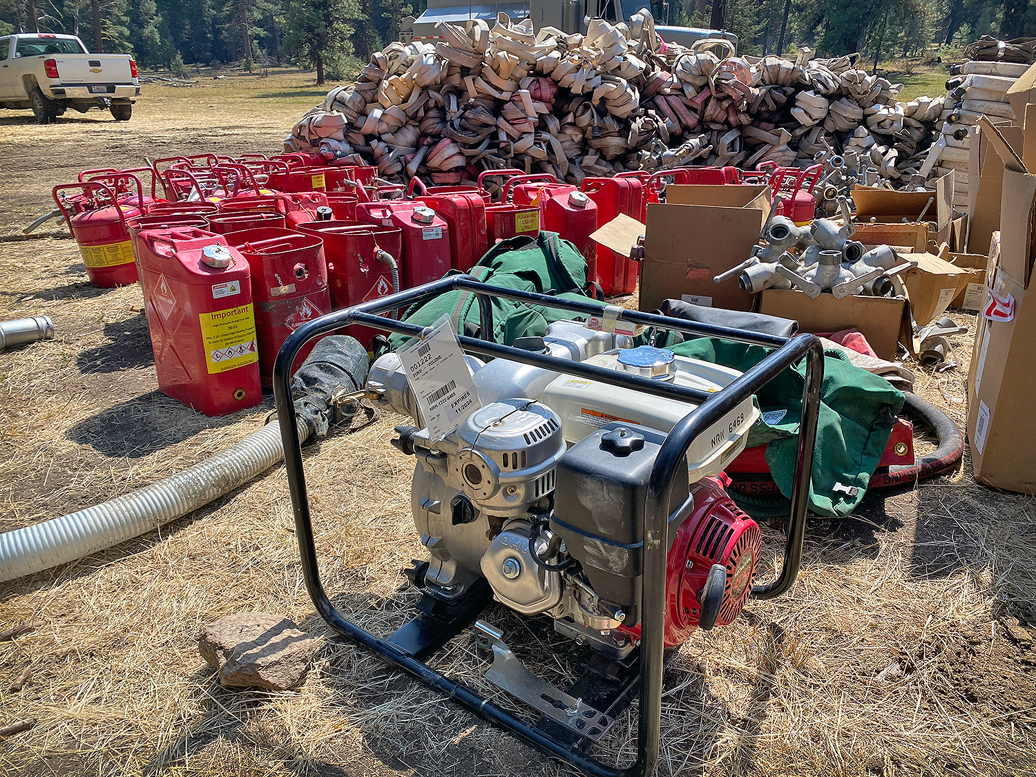
Pumps and Hose Staged for Backhaul Falls & Telephone Fires. Credit PIO J Mike Johnson
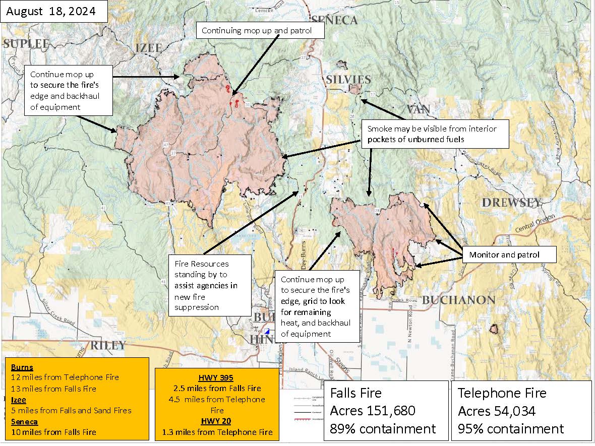
Aug 18th Map of the Falls & Telephone Fires
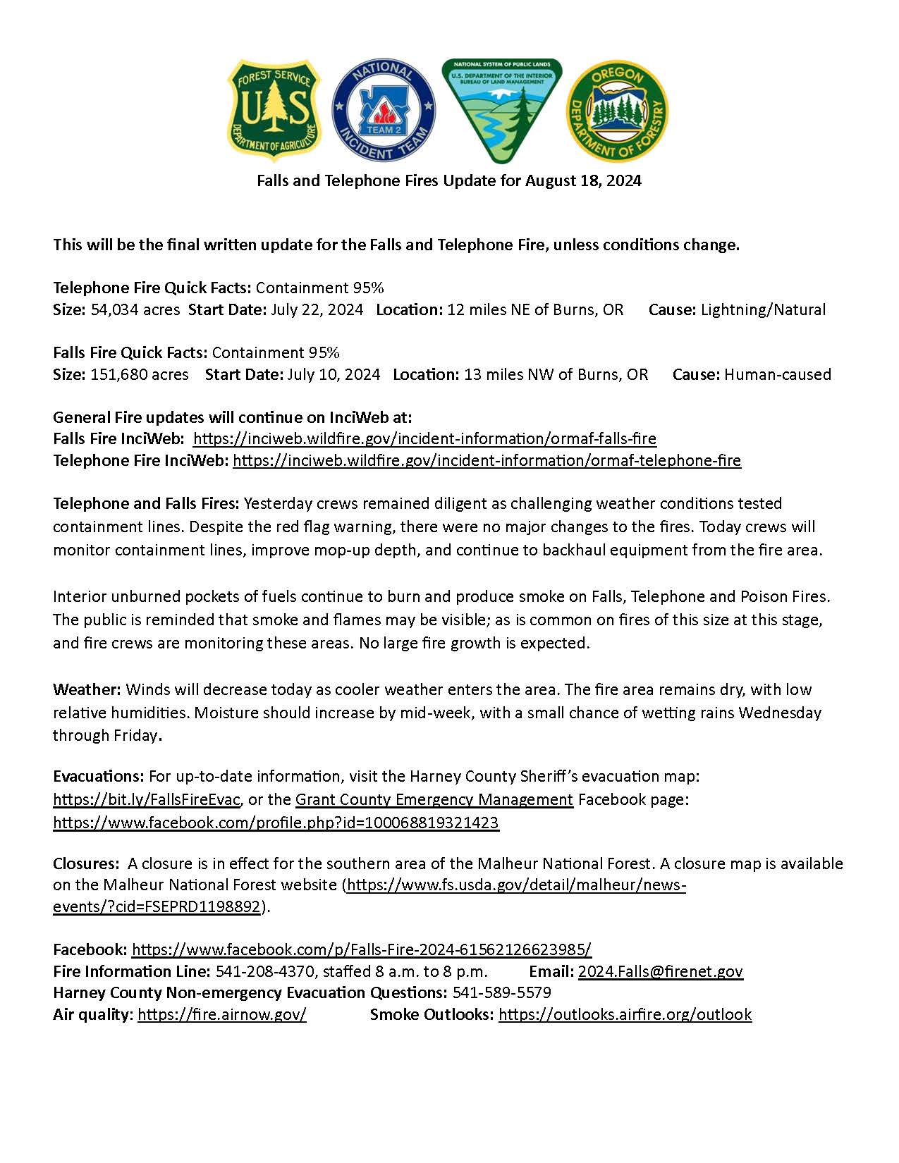
Aug 18th Final Update of the Falls & Telephone Fires
The Telephone Fire started on July 22, 2024, approximately 15 miles north of Burns, Oregon, in the King Mountain area on the Emigrant Creek Ranger District of the Malheur National Forest. The Forest Service, Oregon Department of Forestry, Bureau of Land Management, and Oregon State Fire Marshal are working in partnership with fire managers. A full-suppression strategy is being used for the fire, while insuring to minimize risks to responders and the public.
Initial attack resources attempted direct tactics early on but were challenged by the terrain and accessibility to the eastern side of the fire. Full suppression efforts are being implemented utilizing a combination of direct, indirect, and point protection where the highest probability of success can be safely achieved.
Evacuation Information
All evacuations for Harney and Grant Counties have been lifted as of 8/20/2024.
Closures
The Malheur National Forest has a closure order in place. To protect public health and safety, fire managers have closed the area around the fire due to fire activity and fire suppression operations.
Campground closures include:
- Emigrant Creek Campground
- Falls Campground
- Yellowjacket Campground
- Delintment Lake Campground
Malheur National Forest Detailed Closure Map. For more Forest-related information, visit the Malheur National Forest webpage.
For up to date Oregon Road Conditions.
Air Quality Fire and Smoke Map
Hunting Information
Hunting and Fire Danger in Oregon - Oregon Department of Fish and Wildlife (ODFW) Webpage and ODFW Facebook Page.
Hunters, anglers, wildlife watchers: What to know about wildfires. Wildfire season is hitting Oregon hard. Here's what hunters and anglers should know:
"As early season hunters know, dry conditions and the associated wildfire danger can have a large impact on your hunting opportunity. Check below for resources for finding fire closures and restrictions, and for ODFW's policy on tag refunds and restoration of preference points."
You can check for the latest fire updates and closures using the links on the ODFW webpage. This page will also describe ODFW policies on refunding tags and reinstating preference points. You can also check out the ODFW Active Large Fires and Wildlife Management Units.
| Current as of | Fri, 08/23/2024 - 00:07 |
|---|---|
| Incident Time Zone | America/Vancouver |
| Incident Type | Wildfire |
| Cause | Lightning |
| Date of Origin | |
| Location | 16 miles north east of Burns, Oregon |
| Incident Commander | IMT: Northwest Team 2 Incident Commander: Jason Loomis |
| Coordinates |
43° 45' 28'' Latitude
-118° 51' 42
'' Longitude
|
| Total Personnel: | 175 total for Falls, Sand, & Telephone fires |
|---|---|
| Size | 54,005 Acres |
| Percent of Perimeter Contained | 100% |
| Estimated Containment Date | 09/01/2024 |
| Fuels Involved | Timber (Grass and Understory) |
| Significant Events | Minimal Narrative: |
| Planned Actions |
Crews and equipment will continue repair and backhaul operations. Resources have been identified for initial attack in support of the local units. |
|---|---|
| Projected Incident Activity |
Fire behavior will be minimal over night with good humidity recoveries except for potential |
| Remarks |
NW2 will transition with Idaho 1, type 3 team on 8/23 at 0600. Decrease in acres due to better mapping no new growth since reaching 100% containment. |
| Weather Concerns | Elevated fire weather conditions occurred over the Falls and Telephone fires today with minimum relative humidities dropping into the teens as high temperatures rose into the mid 70s to low 80s. Winds were from the south-southwest at 6 to 12 mph with gusts as high as 22 mph. Significant changes will begin tonight as the upper level area of low pressure that has been residing off the Oregon Coast will move inland. There is a chance of showers and thunderstorms overnight tonight, and a better chance late Friday morning into Friday afternoon. Any thunderstorms that do form will likely produce light rainfall and could produce outflow winds as high as 35 mph. High temperatures will also plummet with highs only in the 60s expected Friday through Sunday. Friday will also bring breezy southwest winds to the fire, though relative humidity will remain 35% or better. Temperatures may drop below freezing on Sunday morning. |
|---|