
Gold Complex morning update July 26 2024 07 26 2024
Related Incident: Gold Complex
Publication Type: News
Quick Facts
- Acres: Mill, 2,962; Smith, 45
- Containment: Mill 10%; Smith 60%
- Detection Date: July 22, 2024
- Cause: Lightning
- Fixed wing: available as needed
- Crews: 13
- Engines: 97
- Dozers: 7
- Helicopters: 9 + mapping-capable UAS
- Total resources: 765
Headlines
• As of Thursday, some evacuations have been downgraded. For specific evacuation information, please visit: facebook.com/plumascountysheriff or facebook.com/sierracosheriff
• Join us for another Ask-the-Incident Commander meeting daily at 2 pm. (Technology permitting) on facebook.com/USFSPlumas
Operational Update
Smith Fire: Infrared mapping is showing very little heat remaining, and crews will continue today to patrol and mop up any heat sources that could threaten containment.
Mill Fire: The Mill Fire is also showing reduced heat. Infrared mapping showed some minor lingering heat northeast of Whitehawk and crews will focus on that today. Other priorities include completing contingency lines that were put in to protect communities and energy infrastructure and backhauling any unused equipment and trash. Areas of heat remain inside containment lines and area residents and visitors can expect to see isolated smokes in the coming days.
Weather
Dry weather with a gradual cooling trend is expected today. Winds are predicted to increase around the fire area in the afternoon, but not to critical levels.
#####
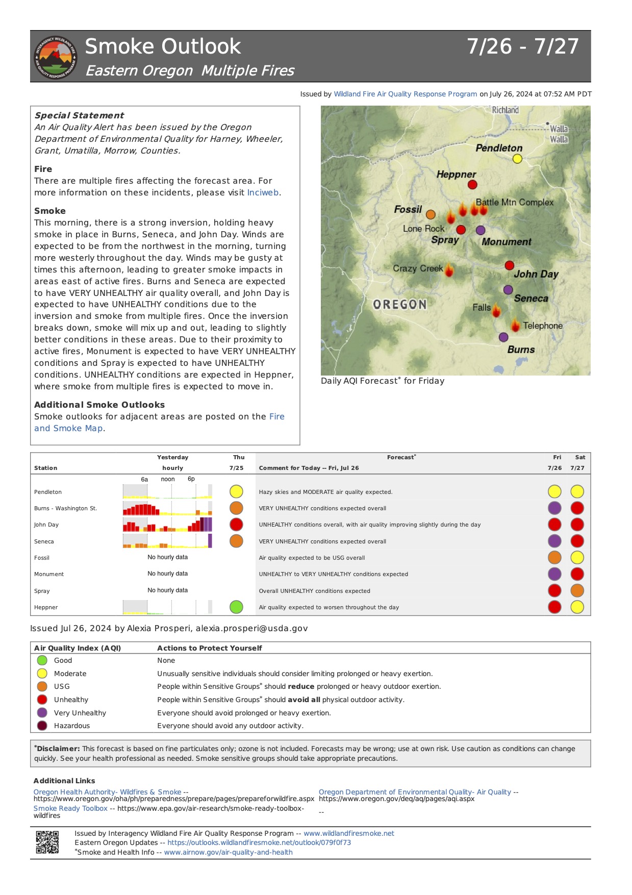
Smoke Outlook Eastern Oregon July 26 202407 26 2024
Related Incident: Lone Rock Fire
Publication Type: News
Smoke Outlook 7/26 - 7/27 Eastern Oregon
Special Statement
An Air Quality Alert has been issued by the Oregon Department of Environmental Quality for Harney, Wheeler, Grant, Umatilla, Morrow, Counties.
Fire
There are multiple fires affecting the forecast area. For more information on these incidents, please visit Inciweb.
Smoke
This morning, there is a strong inversion, holding heavy smoke in place in Burns, Seneca, and John Day. Winds are expected to be from the northwest in the morning, turning more westerly throughout the day. Winds may be gusty at times this afternoon, leading to greater smoke impacts in areas east of active fires. Burns and Seneca are expected to have VERY UNHEALTHY air quality overall, and John Day is expected to have UNHEALTHY conditions due to the inversion and smoke from multiple fires. Once the inversion breaks down, smoke will mix up and out, leading to slightly better conditions in these areas. Due to their proximity to active fires, Monument is expected to have VERY UNHEALTHY conditions and Spray is expected to have UNHEALTHY conditions. UNHEALTHY conditions are expected in Heppner, where smoke from multiple fires is expected to move in.
Additional Smoke Outlooks
Smoke outlooks for adjacent areas are posted on the Fire and Smoke Map.
Lone Rock Fire Update July 26 2024 07 26 2024
Related Incident: Lone Rock Fire
Publication Type: News
LONE ROCK FIRE UPDATE July 26, 2024
Location: Lonerock, Ore. to west of Highway 207 | Size: 136,561 acres | Containment: 45% Cause: Under Investigation
Start Date: July 13, 2024 | Total Personnel: 926
InciWeb: https://inciweb.wildfire.gov/incident-information/orprd-lone-rock-fire
Fire Information Line: 541-208-4369
Email: 2024.0404rvlonerock@firenet.gov
Condon, Ore. — The Lone Rock Fire is being managed under a full suppression strategy by the unified command of the Northwest (NW) Team 2 and Oregon State Fire Marshal (OSFM) Red Team.
There will be a community meeting tomorrow, Saturday, July 27 at 6:00 p.m. at the Grade School Gym located at 392 Main Street, Fossil, Ore. The meeting will also be available on the Lone Rock Fire Facebook page.
Yesterday’s Activities: Crews were successful at keeping the fire within its existing footprint and continued to focus on patrol and mop-up operations. Minimal to moderate fire behavior was observed across the entire fire area. Containment of the Lone Rock Fire increased to 45 percent.
Hoselays were put in place at the previous spot fire near Notch Road, and firefighters were able to use these resources to assist in mop-up operations there. Crews also completed strategic firing operations yesterday morning to better secure the spot fire near Flatiron Spring.
Firelines held well in the southern portion of the fire, including along OR 19 and Alder Creek Road. Crews continued to monitor and mop-up isolated interior hot spots. North of Forest Service Road (FSR 25), crews worked to complete a small firing operation to remove the remaining unburned fuels. As of 8:00 p.m. on Thursday evening, OR-19 and OR-207 were fully reopened to traffic.
Today’s Activities: The focus today will be on continuing to mop-up and patrol existing line across the fire area, as well as further securing the spot fires on the east and west sides of the fire perimeter. Lines have held around these areas of concern for several days now. Crews are evaluating the unburned pocket of fuels on the west side of the fire and may conduct strategic firing operations if necessary.
Due to the tremendous work by firefighters and the completion of mop up work around homes, the threat to structures has reduced greatly. As a result of that progress, some Oregon State Fire Marshal (OSFM) task forces and the OSFM incident management team will complete their shift today and then be reassigned to nearby fires or return home to protect their local communities on Saturday. The OSFM Red Team and all of its structural firefighters that have protected Spray, Ore. and served on the fire would like to thank the communities affected by this fire for their support.
Evacuations:
- For information on evacuations in Gilliam County, visit Gilliam County Sheriff's Office Facebook page.
- For information on evacuations in Wheeler County, visit Wheeler County Sheriff’s Office Facebook page.
- For information on evacuations in Morrow County, visit Morrow County Sheriff's Office Facebook page.
Shelters:
• An evacuation center has been set up at the Wheeler High School (600 E B Street, Fossil, Ore.). A large animal shelter is available at the County Fairgrounds (720 E 3rd Street in Fossil, Ore.).
Closures:
• OR-19 and OR-207 were fully reopened to traffic on Thursday, July 25 at 8:00 p.m. For updated
road closure information, visit https://www.tripcheck.com/.
Weather: Friday will be a little warmer with temperatures in the upper 70s and 80s, and relative humidity values in the teens. Winds will shift to northeasterly on ridge tops, but a little weaker with sustained speeds of 4-7 mph.
- Umatilla National Forest Order Number 06-14-02-24-02 includes prohibitions within the Heppner Ranger District on the Umatilla National Forest.
- Bureau of Land Management Prineville District Office issued an Emergency Public Land Closure on BLM-managed lands along the main stem John Day River from Kimberly, Ore. to Dale, Ore.; and along the North Fork John Day River from Kimberly, Ore. to Dale, Ore.
Smoke Information: Visit https://fire.airnow.gov/ for local air quality information.
Flight Restrictions: A Temporary Flight Restriction (TFR) is in place above the Lone Rock Fire area. Unauthorized drone flights (UAS) pose serious risks to firefighter and public safety and the effectiveness of wildfire suppression operations.
###
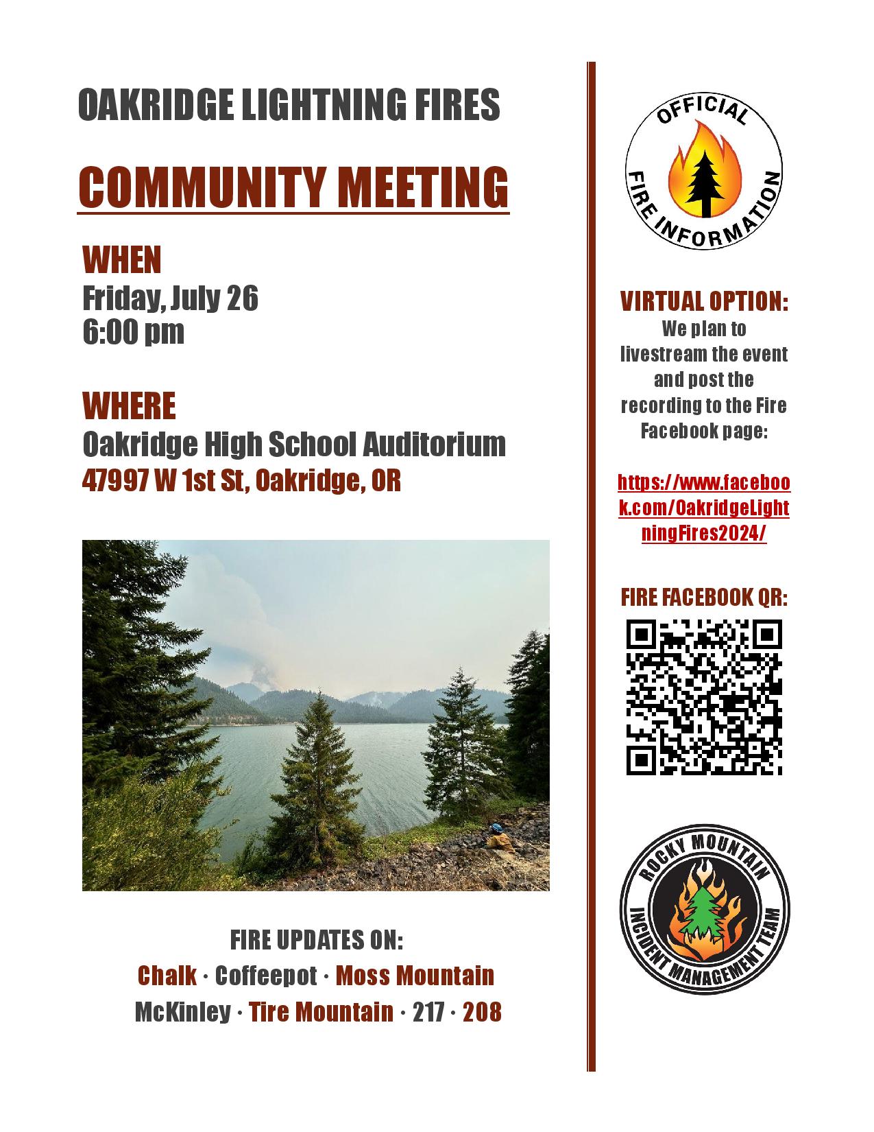
Oakridge Lightning Fires 2024 Public Meeting 6 pm Friday 07 26 2024
Related Incident: Willamette Complex Fires - South
Publication Type: Announcement
The Rocky Mountain Complex Incident Management Team 1 will hold a public meeting in the Oakridge High School auditorium on Friday, July 26 at 6 p.m. The address for the high school is 47997 W 1st street, Oakridge, OR. The event will be livestreamed and a recording posted to the Fire Facebook page.
Fire managers and officials will provide fire updates on the Chalk, Coffeepot, Moss Mountain, McKinley, Tire Mountain, 217 and 208 Fires.
Please consider attending either onsite or virtually.
Tanques Wildfire News Release July 25 2024 07 25 2024
Related Incident: Tanques Wildfire
Publication Type: News
Forest Service News Release
Santa Fe National Forest Manages lightning-caused Tanques Fire
Cuba Ranger District, Cuba, N.M., July 25, 2024— The lightning caused Tanques Wildfire, located in the northwest corner of the Cuba Ranger District, around 25 miles north of Cuba, NM, was first reported the morning of July 18. Currently, the fire is 13 acres, burning in ponderosa pine, pinyon-juniper, and oak.
Santa Fe National Forest will manage the fire as a Type 3 incident with a confine and contain strategy. This means crews will manage the fire within a predetermined area (confine) and use points to stop the fire’s spread (contain). To accomplish this strategy, crews will conduct firing operations using aerial and hand ignitions within a 7000-acre planned perimeter as early as July 25 and use roads, hand lines, and natural barriers as containment lines.
The fire is burning in an area that has already gone through the National Environmental Policy Act (NEPA) process and a landscape that has been thinned and treated with prescribed fire in the past. The primary objectives are to provide for firefighter and public safety and improve wildlife habitat. “Successful completion of this work will provide the elk and mule deer populations improved forage habitat for many years to come,” said Cuba District Ranger Patrick Petracca.
Fire crews are working with stakeholders and mitigating any risk to private landowners in the vicinity. There are no risks to nearby communities and no evacuations will be required. There will be a closure of roads around the planned perimeter of the project area during ignition operations.
Smoke may be visible from communities along Highway 112 including El Vado and Llaves, NM and from the Jicarilla Apache Nation Indian Reservation. View an interactive smoke map on AirNow Fire and Smoke Map. To learn more about smoke impacts visit Wildfire and Prescribed Fire Smoke Resources (nm.gov).
Fire Information
Contact Claudia Brookshire, Public Affairs Officer, Santa Fe National Forest
Phone: 505-607-0879 (available from 8:00 am to 7:00 pm)
Email: claudia.brookshire@usda.gov
Links: Santa Fe National Forest website, New Mexico Fire Info, Inciweb, and Santa Fe National Forest social media (Facebook and X).
###
USDA is an equal opportunity provider, employer and lender.
Battle Mountain Complex Zone 2 07 26 2024
Related Incident: Battle Mountain Complex
Publication Type: News
Weather gives slight reprieve, much work to be done
UKIAH, Ore. – Zone 2, the eastern half of the Battle Mountain Complex, now comprised of the 140,879 -acre Monkey Creek Fire and the 4,484 North Fork Owens Fire, continues to test fire lines.
Cooler conditions and blue skies were a sight for sore firefighter eyes today as crews and aircraft began to see the slimmest light at the end of the tunnel. While the fire remains active on the south end of the Monkey Creek Fire, ground resources working in conjunction with helicopters kept things in check.
On the eastern edge, the fire is holding after burn operations cleared out brush and other flashy fuels along Highway 395. Crews made progress tying in where the fire slopped over on the southeast portion where fire was active but less active than the past few days. Crews are preparing to remove vegetation through burning operations along Camas Creek where fire is still creeping through unburned areas.
“This fire is very terrain driven. We have many miles of dozer line to put in on the flats where the fire is coming out of the drainages,” said Field Operations Section Chief Eric Perkins. “We’re trying to shore up our lines to stop it from spreading north and south.”
Structural taskforces continue to do great work battling direct suppression around homes and outbuildings.
The 4,484-acre North Fork Owens Fire is now 70% contained (the complex stands at 5% containment).
The Battle Mountain Complex consists of the North Fork Owens and Monkey Creek Fires – two of 17 fires in northeast Oregon that started in the late afternoon and evening of July 17, 2024. The Snake Fire merged with the Monkey Creek Fire on July 22, 2024, and the Boneyard Fire merged with Monkey Creek Fire on July 25, 2024.
Evacuations: Level 1 (Be Ready), Level 2 (Be Set) and Level 3 (Go Now) evacuations are in effect. For updated information, visit:
- For Umatilla County, follow facebook.com/UmatillaCountySheriff or sign up for Umatilla County Emergency Alert System at https://member.everbridge.net/index/2590041373147145.
- For Grant County, visit the RAPTOR arcgis site or sign up for alerts at: https://member.everbridge.net/index/825462649520134.
- For Morrow County, visit https://experience.arcgis.com/experience/de78333b0d2544f7a320142174aa20ae
FIRE AT A GLANCE
Total Estimated Size: 140,879 acres
North Fork Owens: 4,484 acres
Containment: 5%
Cause: Under Investigation
Estimated Cost: $7,500,000
All Resources
Hand Crews: 45
Engines: 75
Water Tenders: 34
Dozers: 30
Helicopters: 8
Total Personnel: 1,466
Settings - change map background and toggle additional layers
Filter - control incident types displayed on map.
Zoom to your location
Reset map zoom and position
Could not determine your location.
Show Legend
 Wildfire
 Prescribed Fire
 Burned Area
Response
Burned Area
Response Other
Other
2024 Gwen Fire
Unit Information
Incident Contacts
Big Horn Fire PM Update 07 26 2024
Related Incident: Big Horn Fire
Publication Type: News
Big Horn Fire
9:00 PM, July 25, 2024
Estimated size: 49,063 acres
Containment: 21%
Start Date/Time: 7/22/2024 at 1:07 PM
Area of Origin: 7 miles SE of Bickleton, WA
Cause: Undetermined
Structures Damaged: 4
Update: Today crews worked with Klickitat County Fire District 10 and other cooperators as they made progress on the east side of the fire following last night spread towards the Alderdale area. Crews on other portions of the fire made progress on securing fire lines along the northwest corner and the west flank on Middle Road.
The fire has reached Highway 14 which will remain closed overnight as the fire continues to burn along the highway. The road has been closed for the safety of the public due to fire activity and low visibility caused by smoke. In cooperation with the BSNF Railroad, the fire train traveled through the area to patrol hot spots along the rail line.
Night shift operations continue this evening and into the morning, as crews continue to work today’s efforts throughout the night.
Evacuation Levels: Evacuation levels remain in effect. Please visit Klickitat County Emergency Management’s website or check Facebook:
Road Closures: East Road is closed from the Town of Bickleton south to Middle Road. Hwy 14 from the Town of Roosevelt to Alderdale Road. Alderdale Road from Linda Lane south to the intersection with SR 14.
Weather and Fire Behavior: A cold front brought gusty conditions last night and into today. Warm and dry conditions continue with wind gusts around 20 mph.
Smoke: While there are no current air quality alerts for Klickitat County, communities close to active wildfires could see air quality worsen as the fire and wind conditions change. Critical fire weather continues across Central and Eastern Washington; please continue to recreate responsibly as any fire starts could spread quickly. For more information on smoke and air quality, please visit: Washington Smoke Information (wasmoke.blogspot.com)
Shelter: An American Red Cross Shelter has been opened in neighboring Benton County and is currently assisting individuals and families that are displaced by the fire.
Patterson Elementary School
51409 Prior Ave
Patterson, WA 99345
Resources: Multiple overhead, strikes teams, aircraft and dozers are currently responding to the fire.
###
Settings - change map background and toggle additional layers
Filter - control incident types displayed on map.
Zoom to your location
Reset map zoom and position
Could not determine your location.
Show Legend
- Wildfire
- Prescribed Fire
- Burned Area
Response
- Other
Tanques Wildfire
Unit Information
Incident Contacts
Gold Complex evening update July 25 2024 07 26 2024
Related Incident: Gold Complex
Publication Type: News
Quick Facts
- Acres: Mill, 2,962; Smith, 45
- Containment: Mill 10%; Smith 60%
- Detection Date: July 22, 2024
- Cause: Lightning
- Crews: 13
- Engines: 97
- Dozers: 7
- Helicopters: 9 + mapping-capable UAS
- Fixed wing: available as needed
- Total resources: 765
Official Fire Information
Headlines
• As of tonight, some evacuations have been downgraded. For specific evacuation information, please visit: facebook.com/plumascountysheriff or facebook.com/sierracosheriff
• Join us for another Ask-the-Incident Commander meeting TOMORROW (technology permitting), July 26, at 2 p.m. on facebook.com/USFSPlumas
Operational update
Smith Fire: Line around the Smith Fire held through the day. Only two areas of heat remain within the fire interior, and crews and aircraft are working to mop those up today.
Mill Fire: The Mill Fire containment lines have also continued to hold, despite high winds which persisted through the afternoon. During a reconnaissance flight today, fire staff noted several large burning snags which were near containment lines. Crews and aircraft are continuing to work through those areas into the evening to ensure that the fire does not spot outside its current perimeter. There are still unburned areas of vegetation well interior to containment lines, and residents and visitors in the area can expect to see smoke as those ignite and burn.
Weather
Cooler weather is expected to persist into the weekend.