
Actualizacin Diaria de lake e Apache 07 25 2024
Related Incident: 2024 Lake FireApache Fire
Publication Type: News
Inicio del Incendio Lake: viernes, 5 de julio de 2024 a las 3:48 p.m.
Causa: Bajo investigación
Localización: Cerca del Zaca Lake, en el condado de Santa Barbara, al norte de Los Olivos, California.
Tamaño en el momento de la actualización: 38,664 acres
Contención: 90%
Personal: 746
Detalles completos del incidente: https://inciweb.wildfire.gov/incident-information/calpf-2024-lake-fire
Incendio Lake
Los bomberos continúan realizando reparaciones de supresión y están progresando constantemente. Los objetivos generales de estas acciones son reparar los daños causados por las actividades de extinción de incendios, minimizar el impacto ambiental y devolver las áreas impactadas a las condiciones previas al incendio lo más cerca posible. La mayor parte del trabajo en el lado sur del incendio está completa. Las cuadrillas y los equipos mecánicos continúan trabajando en el lado norte del incendio. El terreno en el extremo norte es más montañoso que en la zona sur y las carreteras son angostas. Estas condiciones afectan el ritmo de avance.
Incendio Apache (nuevo incidente)
Un nuevo incendio forestal conocido como el Incendio Apache arde en el Bosque Nacional Los Padres desde el martes por la noche. El incendio está ubicado en Apache Canyon en el extremo sur del Cuyama Valley, al este de Maricopa Highway, en el condado de Ventura. El incendio se estimó en 925 acres el miércoles por la tarde. Se han emitido órdenes de evacuación para las residencias a lo largo de Apache Canyon Road. Existen advertencias de evacuación para las residencias en Burgess Canyon y Quail Springs. El Bosque Nacional Los Padres está bajo el mando unificado con el Departamento de Bomberos del Condado de Ventura y las varias agencias de bomberos que están ayudando.
Se encuentra información sobre el incendio Apache en vcemergency.com, la página web Inciweb del incendio Apache, la página de Facebook del Bosque Nacional Los Padres y las páginas de Facebook del Departamento de Bomberos del Condado de Ventura y de X del Departamento de Bomberos del Condado de Ventura.
El Equipo 2 de Gestión de Incidentes Interagenciales de California ha estado manejando el incendio Lake y asumió el mando del incendio Apache esta mañana.
Pronóstico para el jueves: Las temperaturas de la tarde para el incendio Lake estarán entre los 90 grados y los 100 grados con una humedad relativa mínima del 12 al 28%. Los vientos soplarán del oeste, un poco más fuertes que recientemente. Las temperaturas del incendio Apache serán de 100 a 105 grados con baja humedad. Se pronostica que estas condiciones persistirán hasta el sábado.
Cierre del área del incendio Lake: Todos los caminos, senderos y áreas recreativas dentro de la Orden de Cierre del Bosque Nacional Los Padres están cerrados al público. Consulte la Orden de cierre y el Mapa de órdenes de cierre mediante enlaces o visitando el sitio web del Bosque Nacional Los Padres. Este cierre permanecerá vigente hasta el 18 de agosto de 2024, o hasta que sea revisado o rescindido.
Áreas de evacuación: Todas las órdenes de evacuación y advertencias de evacuación previamente vigentes debido al incendio Lake han sido canceladas. Se insta a los residentes a tener precaución al regresar a sus hogares ya que el personal de emergencia continúa trabajando en el área. La Orden de Cierre del Bosque Nacional Los Padres todavía está vigente.
Se encuentra más información de evacuación para el incendio Apache en vcemergency.com.
2024 SQF Lightning Smoke Outlook 07 25 2024
Related Incident: 2024 SQF Lightning
Publication Type: News
Fire
Portions of the fire received light precipitation yesterday during afternoon thunderstorm activity. Today, drier air will start to move into the Outlook area and reduce the chance of thunderstorms. Tactical firing operations are possible on the western side of the Trout. Expected fire behavior to include smoldering, single tree/small group torching, spotting, and potential short uphill runs.
Smoke
Yesterday, smoke transport was again impacted by convective thunderstorm activity and stayed local to the fire, before tracking to the S/SE in the evening. Today, a drier westerly flow will begin to setup over the Outlook area and smoke transport will be generally to the east. Western foothill communities should get a bit of a break and see generally GOOD to MODERATE conditions. The north Owens Valley should see generally GOOD conditions with smoke staying to their south. The southern Owens Valley can expect MODERATE conditions during the day with the potential for USG overnight as smoke settles. Westerly winds will increase tomorrow and continue into Saturday.
Lake And Apache Fire Daily Update 07 25 2024
Related Incident: 2024 Lake FireApache Fire
Publication Type: News
Lake Fire Start: Friday, July 5, 2024 at 3:48 p.m.
Cause: Under investigation
Location: Near Zaca Lake in Santa Barbara County, north of Los Olivos, California
Size at time of update: 38,664 acres
Containment: 90%
Personnel: 746
Full Incident Details: https://inciweb.wildfire.gov/incident-information/calpf-2024-lake-fire
Lake Fire
Firefighters continue to engage in suppression repair and are making steady progress. The overall objective of these actions is to repair damage caused by fire suppression activities, to minimize environmental impact and to return impacted areas to pre-fire conditions as closely as possible. The majority of the work on the south side of the fire is complete. Crews and equipment continue to work on the north side of the fire. Terrain on the north end is more mountainous than the southern area and the roads are narrow. These conditions affect the rate of progress.
Apache Fire (New)
A new fire known as the Apache Fire has been burning on the Los Padres National Forest since Tuesday evening. The fire is located in Apache Canyon in the south end of the Cuyama Valley, east of Maricopa Highway, in Ventura County. The fire was estimated at 925 acres Wednesday afternoon. Evacuation Orders are in place for residences along Apache Canyon Road. Evacuation Warnings are in place for residences on Burgess Canyon and Quail Springs. The Forest is in Unified Command with the Ventura County Fire Department and multiple fire agencies are assisting.
Apache Fire information can be found at https://www.vcemergency.com/ on the https://inciweb.wildfire.gov/incident-information/calpf-apache-fire, and the https://www.facebook.com/venturacountyfire/ or https://x.com/vcfd pages.
California Interagency Incident Management Team 2 has been managing the Lake Fire and assumed command of the Apache Fire this morning.
Forecast for Thursday: Afternoon temperatures for the Lake Fire will be in upper 90’s to low 100’s with minimum relative humidity from 12-28%. Winds will be out of the west, slightly stronger than they have been recently.
Apache Fire temperatures will be 100-105 degrees with low humidity. These conditions are forecast to persist through Saturday.
Lake Fire Area Closure: All roads, trails, and recreational areas within the Los Padres National Forest Closure Order are closed to the public. visiting the Los Padres National Forest website at https://www.fs.usda.gov/main/lpnf/alerts-notices This closure will remain in effect until August 18, 2024, or until revised or rescinded.
Evacuation Areas: All Evacuation Orders and Evacuation Warnings previously in place due to the Lake Fire have been canceled. Residents are urged to take caution when returning home as emergency personnel continue working in the area. The Los Padres National Forest Closure Order is still in place. Order 05-07-00-24-17 SPECIAL CLOSURE-Lake Fire Closure Area with Exhibit A 071224 JED.pdf (inciweb-prod-media-bucket.s3.us-gov-west-1.amazonaws.com)
Microwave Tower Fire Update Thursday 07 25 2024
Related Incident: Microwave Tower Fire
Publication Type: News
Fire Information: (541) 903-2069 daily from 8 a.m. - 8 p.m.
Email: 2024.microwavetower@firenet.gov
Microwave Fire Facebook: https://www.facebook.com/2024MicrowaveTowerFire/
InciWeb: https://inciweb.wildfire.gov/incident-information/or954s-microwave-tower
14% Contained
704 Acres
5 miles west, southwest of Mosier, OR
Burning in brush, timber, and grass
Highlights
The Microwave Tower Fire is now at 14% containment. Further containment is expected as the south end of the fire moves into mop up. Because the area has difficult terrain, crews are leveraging local knowledge and experience to enhance the effectiveness of using the railroad tracks as a line tie-in feature for the west and east ends of the fire. When completed, this would remove fuels and reduce the risk of fire spread.
Fire Behavior
The fire continues to show moderate activity with the potential for increased spread through spotting, single tree torching and group torching in the timber draws. We may see an increase in fire behavior depending on changing weather conditions. Along the north end of the fire, pockets of burning and smoldering smoke can be seen from I-84.
Today, crews will work to improve dozer line connecting to the Historic Columbia River Highway State trail. There are 115 personnel assigned to the fire, up 43 from the previous day. The weather forecast predicts cooler temperatures, higher humidity, and lower winds that will provide an opportunity to increase progress for firefighters.
Evacuations
The evacuation preparedness level was set to Level 1 - Be Ready, west of the fire as a precautionary measure. Existing evacuations remain in place. Power was restored to the City of Mosier, but a Red Cross center remains open at the Hood River Middle School for anyone needing a place to go.
The Mosier Senior Center at 500 E. 2nd Ave., is being used as a cooling center for the public where they can also charge their devices. For up-to-date information on evacuations please visit https://www.facebook.com/WascoCountySheriff.
###
2024 SQF Lightning Daily Incident Update 07 25 2024
Related Incident: 2024 SQF Lightning
Publication Type: News
Trout Fire: 22,231 acres - 10% containment
Long Fire: 9,204 acres - 25% containment
Borel Fire: 941 acres - 0% containment
Total Personnel: 1,095
Current Situation: Yesterday around 1 p.m., firefighters responded to a vegetation fire—Borel Fire—burning on both sides of State Route (SR) 178, east of Democrat Springs. Despite an aggressive initial attack with numerous interagency resources—crews, engines, aircraft, dozers—the fire spread quickly up steep canyon walls in hot, dry, windy conditions. California Interagency Incident Management Team 14 is managing the fire as part of the 2024 SQF Lightning incident. Kern County Fire Department issued an evacuation warning for zone KRN-403-A. SR 178 is closed from 4.1 miles east of the junction of SR 184 to Democrat Springs (Kern Co).
Trout Fire: Fire growth was minimal Wednesday despite gusty winds and minimal precipitation from afternoon thunderstorms. On the fire’s east side, crews extended and strengthened the containment fireline from Bald Mountain Lookout near Sherman Pass Road to Lunch Meadow. Today, crews will be flown in by helicopter to work and camp for several days on the southern and southeastern perimeter. On the west side, heavy-equipment operators are constructing containment line southward from Sherman Pass Vista toward Big Meadow.
Long Fire: Crews continue to make progress containing the fire on the northwest side from Palome Creek as they advance northeastward to the head of the fire where other firefighters are constructing handline from the head of the fire near the Pacific Crest Trail southwestward toward Palome Creek. Engine crews are also working along control lines to extinguish any smoldering fires that could lead to the fire escaping its perimeter.
Borel Fire: Numerous resources are working to fully contain the fire. Fire behavior Thursday is expected to be extreme with rapid rates of spread. SR 178 remains closed in the fire area.
Weather & Air Quality: Near all three fires, drier and slightly cooler conditions are expected today with wind gusts up to 30 mph possible. A daily smoke outlook is produced for the areas and communities affected by the 2024 SQF Lightning fires (tinyurl.com/452x2uzr).
Closures & Restrictions: State Route 178 is closed from 4.1 mi east of the junction of SR 184 to Democrat Springs (quickmap.dot.ca.gov/). Sequoia National Forest lands, roads, trails, and recreation sites around the Trout and Long Fires are temporarily closed under Forest Order No. 0513-24-12. Fire restrictions are also in effect under Forest Order No. 0513-24-10. Both orders, maps, and accompanying appendices can be found on the Forest’s “Forest Orders” web page: tinyurl.com/2en2d36k. The Bureau of Land Management’s Bakersfield Field Office has temporarily closed Long Valley Campground, Chimney Creek Campground, and portions of the Pacific Crest Trail. View the emergency closure order here: tinyurl.com/4mprcb9b. The PCT is closed between Hwy 178 at Walker Pass (mile 653) and the South Fork of the Kern River bridge (mile 717.7).
Evacuations: A Kern County evacuation warning is in effect for zone KRN-403-A. Tulare County evacuation warnings are in effect for zones TLC-E274-B and TLC-E261-B. Tulare County evacuation advisories are in effect or zones TLC-E297-A, TLC-E250, TLC-E274-A, and TLC-E261-A.
Baker County Evacuation Levels Update July 24 1004 PM 07 25 2024
Related Incident: Durkee Fire
Publication Type: Announcement
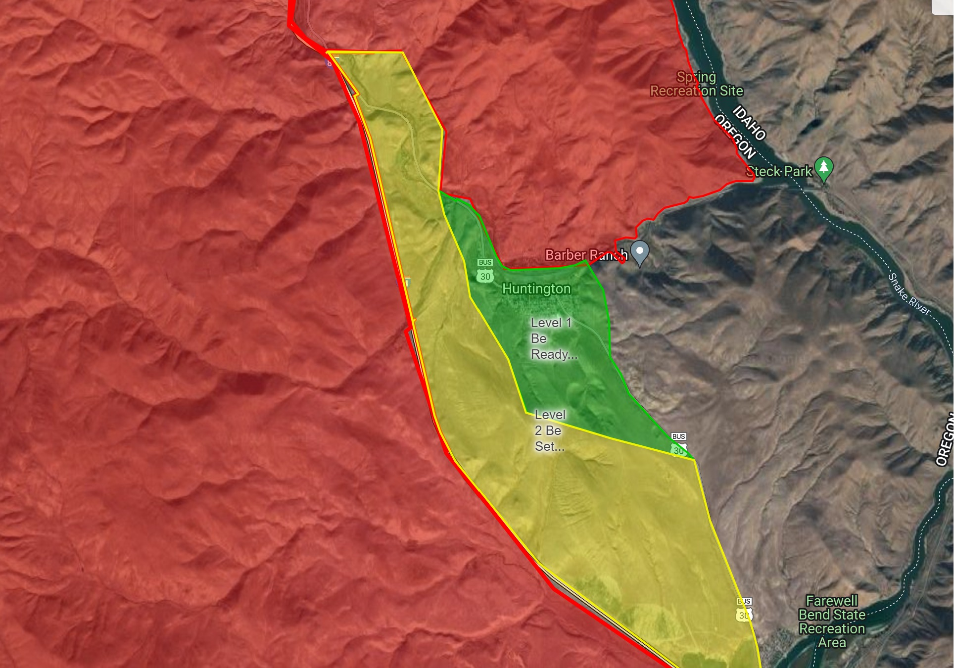
City of Huntington Evacuation Level Update-
After conferring with fire officials and evaluating the situation, Baker County Sheriff's Office reduced the evacuation level for the City of Huntington to a Level 1 (BE READY).
Check back tomorrow for additional updates on evacuation level: https://www.facebook.com/profile.php?id=100064434892363
Smoke Outlook Eastern Oregon July 25 2024 07 25 2024
Related Incident: Lone Rock Fire
Publication Type: News
Smoke Outlook 7/25 - 7/26 Eastern Oregon Multiple Fires
Special Statement
An Air Quality Alert has been issued by the Oregon Department of Environmental Quality for Harney, Wheeler, Grant, Umatilla, Morrow, Counties.
Fire
There are multiple fires affecting the forecast area. For more information on these incidents, please visit Inciweb.
Smoke
Smoke from numerous fires is impacting the area. Winds are expected to be from the west-northwest throughout the day, leading to more smoke in areas southeast of fires. Monument is expected to have VERY UNEHALTHY air quality due to its proximity to multiple fires. Spray is also close to many fires and is expected to have UNHEALTHY air quality. Burns, John Day, and Seneca are expected to have UNHEALTHY air quality. In these areas, air quality will improve during the day and worsen overnight as smoke settles in. Smoke from outside the outlook area will occasionally impact Fossil, Heppner, and Pendleton, where MODERATE conditions are expected overall, with some hours of GOOD as well.
Settings - change map background and toggle additional layers
Filter - control incident types displayed on map.
Zoom to your location
Reset map zoom and position
Could not determine your location.
Show Legend
 Wildfire
 Prescribed Fire
 Burned Area
Response
Burned Area
Response Other
Other
Muir Creek Fire
Unit Information
Incident Contacts
Ore Fire Update 07 25 2024
Related Incident: Ore Fire
Publication Type: News
Ore Fire Update
Thursday, July 25, 2024 – 9:30 a.m.
Size: 1050 acres | Reported Date: July 16, 2024 | Cause: Under Investigation | Containment: 2%
Total Assigned Personnel: 285 | 8 engines | 4 hand crews | 3 dozers | 18 water tenders | 4 masticators | 4 feller bunchers
(Blue River, Ore.) – Fire suppression efforts continue on the Ore Fire, which is burning 7 miles northeast of Blue River, Oregon. Challenges include steep and rugged terrain, falling rocks, rolling debris and fire-weakened trees. Firefighter and public safety remain the number one priority on the incident. Fire managers are focusing on activities with a high probability of success while minimizing risk to firefighters and protecting values such as communities, infrastructure and forest, recreation and cultural resources. Due to increased fire activity, smoke is having a greater impact on surrounding communities. Monitors are being set up to assess air quality.
Complex Incident Management Northwest Team 10 is utilizing the Incident Strategic Alignment Process (ISAP) in coordination with the local unit to make informed, risk-based decisions during the ongoing Ore Fire. This process establishes a shared understanding and alignment on prioritizing work and protected values while managing risk.
Yesterday, crews secured and monitored slopovers (the fire’s edges that crossed over the control line) on the FS 1509 Road which continue to hold. Fire activity increased in the afternoon and aviation support helped to cool hot spots. The FS 1509 Road was plumbed with hose lines and sprinklers to wet the green side of the control line and make the fuels less receptive to fire. Graders improved road conditions north from the FS 15 Road up the FS 1513 Road. Firefighters working the night shift monitored active fire behavior well into the evening hours.
Today, firefighters will place hose lines and sprinklers along the FS 15 Road. Rolling debris and falling trees continue to threaten the line as firefighters monitor and patrol the FS 1509 Road, where the fire is slowly backing down the hillside. Increased fire activity is expected in the afternoon.
Weather: Mostly cloudy skies associated with the marine layer are expected to move out of the area by the morning hours leaving sunny skies in the afternoon. Complete inversion breakup may be delayed until mid-afternoon, allowing smoke to linger. Slightly warmer and drier conditions are expected on Friday.
Safety: While the Ore Fire is not threatening homes, wildfire season is just beginning. Sign-up now to get critical alerts about wildfires and other emergencies at https://www.lanecounty.org/sign_up_for_notifications. Fire restrictions are in place within the Willamette National Forest. For more information visit https://www.fs.usda.gov/main/willamette/fire. A Temporary Flight Restriction (TFR) is in place over the fire area.
Smoke: Smoke from numerous wildfires burning throughout the region will affect air quality in many areas over the coming days. A daily smoke outlook can be found at https://wildlandfiresmoke.net. Being prepared for smoke is important to everyone’s health. For more information, go to: www.airnow.gov/wildfires/be-smoke-ready.org/
Forest Closures: Closures in the Willamette National Forest have been established around fire-impacted areas. These closures include the following sites: Buck Mountain Trail, Tidbits South and West Trail, Gold Hill Trail, Mona Campground, Lookout Campground, and Saddle Dam Boat Launch. For a complete list of recreation and roads in the Ore Fire closure order, visit https://www.fs.usda.gov/alerts/willamette/alerts-notices
Durkee and Cow Valley Fires Daily Update 07 25 2024
Related Incident: Durkee FireCow Valley Fire
Publication Type: News
Durkee, Cow Valley, and Bonita Fires Update for Thursday, July 25, 2024
541-208-4371, staffed 7AM to 7PM PDT
DURKEE FIRE: Start date: July 17, 2024 | Location: 5 miles southwest of Durkee, OR | Personnel: 514 | OSFM Task Forces: 4 | Fire size: 268,492 acres | Cause: Lightning | Containment: 0%
Today, moderate fire behavior is expected.
Moderate post-frontal weather conditions are forecasted (including a slight drop in temperature, higher humidity, calmer winds and a low probability of thunderstorms). Firefighters will seize the opportunity to employ direct strategy with handline, heavy equipment and other means to continue their full suppression efforts.
Today’s fire operation priorities include containment in the Bridgeport, Shirttail Creek Road and Rye Valley areas. Where firefighters were successful holding the fire edge in the I-84 corridor, mop up around structures is also a focus.
Yesterday, gusty and erratic winds, lightning and flash flood warnings were present. At higher elevations, red flag outflow winds brought on by back-to-back thunderstorms initially formed a southeast front with 45 mph gusts. Observed near Unity, winds increased to 66 mph. 55 mph gusts were seen throughout the night.
Although yesterday’s weather conditions caused spot fires (also known as a slop-over) in many areas, firefighters saw a lot of successes catching them. During the height of extreme fire behavior conditions and heavy gusts, one report noted a 30-acre slop-over across HWY 30 at 3:30pm. The Oregon State Fire Marshal and NW Team 6 operations acted in partnership with railroad operations to contain fire that threatened three structures.
Aerial resources will be coordinated and prioritized between the Badlands Complex, Durkee Fire and Vale BLM going forward due to state-wide fires and resource availability.
Areas in the Durkee fire footprint experienced up to ½ an inch of precipitation and reports of debris flows are expected. However, the north end of the Durkee fire only saw 2/10 of an inch of rain and fire behavior is still expected to be active in days to come, across the Durkee fire footprint.
Be aware, hazardous air warnings are in place across the Durkee Fire footprint. For current smoke information, visit airnow.gov
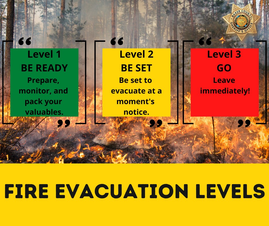
The Malheur County Sheriff’s Office and the Baker County Sheriff’s Office have issued evacuations for multiple areas. Residents in Level 3 Evacuations “GO NOW”, should leave immediately. Residents should not return to their property until evacuation levels have been removed. Carry enough supplies to support you and your family for multiple days. A real time map of fire evacuations can be found at the State of Oregon Fire Dashboard.
Weather and fire behavior could impact transportation, power transmission, cell service and other utilities. Monitor these resources for additional information.
- Oregon Department of Transportation - TripCheck.com
- Idaho Power - IdahoPower.com
- American Red Cross of Eastern Oregon and Idaho - https://www.redcross.org/local/idaho.html
The Durkee Fire is located west of Interstate 84 (I-84). The Thompson Fire, a convergence of lightning fires that started near Thompson Creek on July 22, is located east of I-84. Both have grown rapidly with the persistent high temperatures, strong winds, and extremely dry fuels. Although moderate fire behavior and weather conditions are expected today, be aware of the possibility of fire growth.
BURN BAN: A burn ban is currently in effect for all of Malheur County, including all BLM lands. For more information, visit https://www.malheurco.org/category/public-notices/.
TEMPORARY FLIGHT RESTRICTION: There is a temporary flight restriction over the Durkee Fire, please remember, if you fly we can’t! If a drone or other aircraft enters the air space, all firefighting aviation equipment will be grounded.
--
COW VALLEY FIRE: Start date: July 11, 2024 | Location: 9 miles east of Ironside, OR | Personnel: 0 | Fire size: 133,490 acres | Cause: Human caused |Containment: 91%
BONITA FIRE: Start date: July 11, 2024 | Location: 9 miles south east of Ironside, OR | Personnel: 0 | Fire size: 2,727 acres | Cause: Human caused |Containment: 90%
--
Durkee and Cow Valley Facebook Page