
Big Horn Fire Daily Update 07 24 2024
Related Incident: Big Horn Fire
Publication Type: News
Big Horn Fire
2:30 PM, July 24, 2024
Estimated size: 18,543 acres
Containment: 1%
Start Date/Time: 7/22/2024 at 1:07 PM
Area of Origin: 7 miles SE of Bickleton, WA
Cause: Undetermined
Structures Damaged: 0
The Big Horn fire is burning near the town of Bickleton in Klickitat County, Washington. The fire started at approximately 1:07 PM on Monday July 22nd,2024, and was driven by windy and dry conditions.
Overnight firefighting operations and favorable humidity levels led to slowing the spread of the fire on the west flank along the Pine Creek. The fire continues to move to the northwest corner and the west flank, towards the town of Bickleton. At approximately 12:30 PM this afternoon, the Klickitat County Sheriff’s Office released new information regarding evacuations. Some areas have been downgraded in evacuation level. South of Six Prong and Six Prong Extension to Alderdale Road has been downgraded to level 2.
Alderdale Road to Klickitat County line is downgraded Level 1. To view the new evacuation maps, you can find them on the Klickitat County Emergency Management website and Facebook page.
Today’s focus for firefighting operations has been to install dozer lines, increase of air operations and secure the west flank of the fire. We continue to protect values at risk including lives, property and utility infrastructure.
Road Closures: East Road is closed from the Town of Bickleton south to Hale Rd.
Evacuation Levels: See attached Klickitat County Emergency Management Evacuation map.
Weather and Fire Behavior: Sunny and dry conditions continue today with increase wind gusts. Calm winds will increase into gusty conditions by this afternoon.
Smoke: While there are no current air quality alerts for Klickitat County, communities close to active wildfires could see air quality worsen as the fire and wind conditions change. For more information on smoke and air quality, please visit: Washington Smoke Information (wasmoke.blogspot.com)
Shelter: There are no shelters currently. If you need shelter, please call Klickitat County Dispatch at 509-773-4545.
Resources: Multiple overhead, strikes teams, aircraft and dozers are currently responding to the fire.
###
Evacuation Notices 07 24 2024
Related Incident: Badland Complex 2024
Publication Type: Announcement
Baker County Sheriff's Office has issued level 1, 2, and 3 Level Evacuation Order multiple areas of the fire. For the most up-to-date information please refer to the Baker County Sheriff's Facebook page links below.
A temporary evacuation shelter has been established at the Baker City Church of the Nazarene Family Life Center located at 1250 Hughes Lane. For questions about the temporary shelter, please contact the American Red Cross at 1-800-733-2767.
EVACUATION LEVEL 3 PETER DAN ROAD BUFFALO LAKE MCGINNIS LAKE REYNOLDS RESORT BELVEDERE AND SEATONS GROVE 07 24 2024
Related Incident: Swawilla Fire
Publication Type: News
July 24, 2024 2:50pm
EVACUATION LEVEL 3 - PETER DAN ROAD, BUFFALO LAKE, MCGINNIS LAKE REYNOLDS RESORT, BELVEDERE AND SEATONS GROVE - The Confederated Colville Tribes Office of Emergency Management has elevated the area of Peter Dan Road, Buffalo Lake, McGinnis Lake Reynolds Resort, Belvedere and Seatons Grove to a Level 3 Evacuation. THIS MEANS YOU SHOULD EVACUATE NOW.
Due to increased fire danger from Swawilla Fire, the current Level 2 evacuations status for your area is now elevated to LEVEL 3 EVACUATION.
What does that mean?
Level 3 Evacuation is a GO NOW status. This means that danger is currently affecting your area, and you should leave immediately. There is no time to pack or delay. We cannot force you to leave your home but this is notification of the dangers due to the wildfire.
Immediate Actions to Take:
-Gather Your Family and Pets: Ensure all family members and pets are ready to go.
-Take only essential items: Bring only what is necessary, such as medications, important documentation, and basic supplies.
-Evacuate: using North or South on Highway 155
-Do Not Return Until Authorities Say It’s Safe: If you leave, do not return until authorities have say it’s safe to return home.
Evacuation Shelters:
Lake Roosevelt High School Gym
500 Civic Way
Coulee Dam, WA 99116
Pascal Sherman Indian School
169 North End Omak Lake Road
Omak, WA 98841
Please call EOC at 509-634-7350 or 509-634-7359 for any questions.
Big Horn Fire PM Update 07 23 2024
Related Incident: Big Horn Fire
Publication Type: News
Big Horn Fire
3:00 PM, July 23, 2024
Estimated size: 14,099 acres
Containment: 1%
Start Date/Time: 7/22/2024 at 1:07 PM
Area of Origin: 7 miles SE of Bickleton, WA
Cause: Undetermined
Structures Damaged: 0
The Big Horn fire is burning near the town of Bickleton in Klickitat County, Washington. The fire started at approximately 1:07 PM yesterday afternoon and was driven by windy and dry conditions. At 07:00 AM this morning, a Southeast Incident Management Team Type 3 (SEIMT3) took command of the fire.
This morning, new crews began to work the fire, in three separate Divisions. The fire continues to threaten residential and agricultural properties, critical infrastructure, and the natural gas plant. A night shift operation is planned for tonight to continue today’s progress. The public is urged to stay clear of the fire, downed power lines, and any other hazards within the fire area.
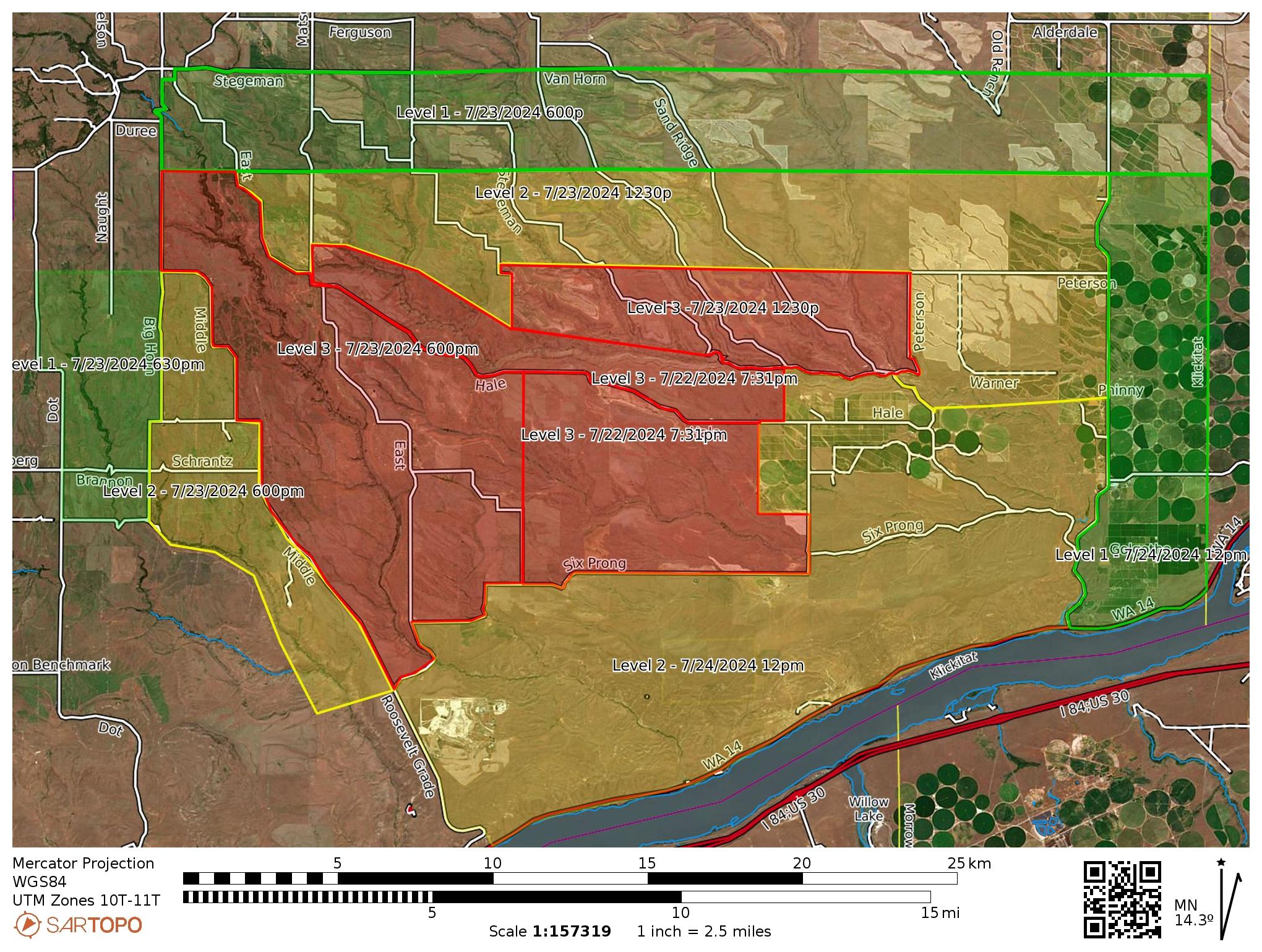
Evacuation levels have been added by the Klickitat County Sherriff’s Office to include new Level 1 areas, additional Level 2 and expansion of the Level 3 areas adjacent to the fire perimeter. This was instituted as a precautionary measure to improve notifications to residents and citizens if conditions change. An updated map has been published by Klickitat County Emergency Mangement.
Road Closures: East Road is closed from the Town of Bickleton south to Hale Rd.
Evacuation Levels:
As of 7/23/2024 at 12:30 PM and most current:
Level 3 "GO NOW" for North of Alder Creek, West to Crider Valley, East to Peterson; and from East Road to Sand Ridge Rd to the East and Alder Creek south to the Columbia River.
Level 2 "GET SET" for Middle Rd to the West, Coleman Rd to the North, Klickitat County Line to the East; and from Sand Ridge Rd to the Klickitat County Line.
Level 1 "GET READY" Evacuation for North of Coleman Rd to Stegeman and Van Horn, West to East Rd, East to Klickitat County Line.
Weather and Fire Behavior: Dry weather continues throughout the day with 0% chance of rain. Daytime humidities remain low and winds continue to be around 5-10 mph.
Smoke: While there are no current air quality alerts for Klickitat County, communities close to active wildfires could see air quality worsen as the fire and wind conditions change. For more information on smoke and air quality, please visit: Washington Smoke Information (wasmoke.blogspot.com)
Shelter: There are no shelters currently. If you need shelter, please call Klickitat County Dispatch at 509-773-4545.
Resources: Multiple overhead, strikes teams, aircraft and dozers are currently responding to the fire.
###
Big Horn Fire Daily Update 07 23 2024
Related Incident: Big Horn Fire
Publication Type: News
Big Horn Fire
10:30 AM, July 23, 2024
Estimated size: 13,800 acres
Containment: 1%
Start Date/Time: 7/22/2024 at 1:07 PM
Area of Origin: 7 miles SE of Bickelton, WA
Cause: Undetermined
Structures Damaged: 0
The Big Horn fire is burning near the town of Bickelton in Klickitat County, Washington. The fire started at approximately 1:07 PM yesterday afternoon and was driven by windy and dry conditions. Since its origin, multiple resources including air operations and approximately 100 fire personnel have responded to the fire on the initial attack. At 5:00 PM, Washington State Fire Mobilization was activated to support the firefighting efforts. Currently, the fire is threatening residential and agricultural lands, critical infrastructure, and a natural gas plant. Public and firefighter safety is the most important thing at a fire. Yesterday, during the initial attack, one firefighter sustained non-life-threatening injuries due to smoke inhalation. They were transported to an area hospital for evaluation.
At 7:00 AM this morning, a Southeast Incident Management Team Type 3 (SEIMT3) took command of the fire and will work closely with Klickitat County Sheriff’s Office, Fire Departments, and Emergency Management agencies.
Road Closures: East Road is closed from the Town of Bickleton south to Hale Rd.
Evacuation Levels:
As of 7/22/2024 at 7:31 PM and the most current:
Level 3 " Go Now ": East Road to Sand Ridge Road to the East and Alder Creek south to the Columbia River.
Level 2 "Get Set": Sand Ridge Road to the Klickitat County Line.
Weather and Fire Behavior: Dry weather is expected throughout the day with 0% chance of rain. Daytime humidities will remain low and winds from 5-10 mph.
Smoke: While there are no current air quality alerts for Klickitat County, communities close to active wildfires could see air quality worsen as the fire and wind conditions change. For more information on smoke and air quality, please visit: Washington Smoke Information (wasmoke.blogspot.com)
###
Settings - change map background and toggle additional layers
Filter - control incident types displayed on map.
Zoom to your location
Reset map zoom and position
Could not determine your location.
Show Legend
 Wildfire
 Prescribed Fire
 Burned Area
Response
Burned Area
Response Other
Other
Big Horn Fire
Unit Information
Incident Contacts
Diamond Complex Daily Update 07 24 2024
Related Incident:
Publication Type: News
Diamond Complex
2024.Diamondcomplex@firenet.gov
Information line: 541-375-0367, 8 am to 8 pm
Facebook: https://t.ly/uX2l7
InciWeb: https://t.ly/hBRYR
July 24, 2024
Firefighters continue to discover new fires resulting from a lightning storm July 16. In the past 24 hours another 8 fires totaling an estimated 62 acres have been identified and added to the Diamond Complex, on the Diamond Lake Ranger District of the Umpqua National Forest.
Currently there are 20 fires totaling an estimated 3,811 acres in the Diamond Complex, with 278 personnel assigned. The Complex is 3% contained. All fires are under a full suppression strategy. Firefighters are directly attacking the fires’ edge where access and firefighter safety allow, and implementing indirect strategies using constructed control lines, and utilizing natural barriers where access issues and safety concerns prevent direct attack.
The fires comprising the Diamond Complex are: Pine Bench, 1,472 acres, and 0% contained, north of Hwy 138 near Dry Creek; Trail, 827 acres and 5% contained, east of Hwy 138 on the west slope of Mt. Thielsen; Lemolo, 518 acres and 0% contained, north of Lemolo Lake on Bunker Hill; Pig Iron, 27 acres and 25% contained, Pig Iron Mountain north of Hwy 138; Watson, 144 acres and 0% contained, north of Hwy 138 on Watson Ridge, Brodie, 95 acres and 0% contained, about 5 miles south of Hwy 138 and south of Devils Canyon; Trep, 101 acres and 0% contained, about 4 miles south of Hwy 138; Garwood, 5 acres and 65% contained, about 3 miles southwest of Mt. Bailey; Slide, 0.1 acres and 90% contained, northeast of Pine Bench; Potter, 372 acres, north of Hwy 138 about 2 miles southeast of Potter Mt.; Ooya, 123 acres, north of Hwy 138 about 1 mile northeast of Bird Point; Clearwater, 7 acres and 90% contained, south of Hwy 138 about 5 miles northwest of Diamond Lake; Elephant, 0.7 acres and 0% contained, 2 miles southwest of Lemolo Lake; Lost Bear, 5 acres and 0% contained, 2 miles south of Hwy 138, and Lost, 12 acres and 0% contained, 4 miles south of Hwy 138. The 8 newest fires totaling 62 acres are widely scattered and have not been named.
Nationally and in the Pacific Northwest, fire activity is putting an extreme demand on firefighting resources. This means that firefighters must carefully prioritize and efficiently utilize available resources to protect values at risk. The highest priority will remain public and firefighter safety and protecting infrastructure and homes.
Yesterday, Northwest Team 7 continued active suppression on the Trail Fire. Afternoon winds increased fire behavior on the northwest flank, pushing the fire into a previous burn scar in the Mt. Thielsen Wilderness where the fire lost intensity. On the Lemolo fire, fire line is established on the east and northeast of the 700 road. Lower humidity and higher wind speeds contributed to increased fire activity. Two helicopters dropped water to slow the fire. The Ooya and Potter fires are showing moderate growth, as firefighters develop a strategy to contain these fires when resources become available. On the Pig Iron fire, work continues to get the fire into patrol status. Access has been established to the Watson fire and a dozer is working the fire. Firefighters worked to keep the Pine Bench fire west of Forest Road 4775, and successfully suppressed several spot fires. Several of the newly identified fires were successfully attacked and contained.
Today, active suppression continues with the Lemolo, Trail, Pig Iron and Pine Bench fires as priorities. Work will continue to get water delivery and fire line established on the Watson Fire.
Weather: Today will be slightly cooler with slightly higher humidity. Exposed, higher elevation fires will see gusty westerly winds. Very dry forest fuels and steep terrain will contribute to potentially active fire behavior.
Closures and Evacuations: Umpqua National Forest has issued two closures across the forest in response to fire activity to protect public and wildland firefighter safety. Emergency Fire Closure ORDER NO. 06-15-24-03 and Emergency Fire Closure ORDER NO. 06-15-02-24-01 which impact all of the Cottage Grove Ranger District, most of the Diamond Lake Ranger District, and parts of the Tiller and North Umpqua Ranger Districts. The closure orders can be found here: https://www.fs.usda.gov/alerts/umpqua/alerts-notices. Additionally, Diamond Lake, Thielsen View, and Broken Arrow Campgrounds are closed through July 28, 2024, and will be reevaluated closer to that date. Fire danger is set at High and Public Use Restrictions are set at Level 2: https://bit.ly/3xIZZdK.
Douglas County Sheriff has issued a Level 3: GO NOW and Level 2: BE SET for the Trail Fire and Lemolo Fire. There is a Level 2: BE SET for the Pine Bench Fire. Please see detailed information here: www.dcso.com/evacuations.
Harney County Sheriffs Office Notice of Possible Power Shutoff Riley and Wagontire 07 24 2024
Related Incident: Falls Fire
Publication Type: Announcement
Harney County Sheriff's Office Notice of Possible Power Outage for Riley and Wagontire
Microwave Tower Fire Update Wednesday 07 24 2024
Related Incident: Microwave Tower Fire
Publication Type: News
Microwave Tower Fire Update
July 24, 2024
Fire Information: (541) 903-2069 daily from 8 a.m. - 8 p.m.
Email: 2024microwave@firenet.gov
Microwave Fire Facebook: https://www.facebook.com/2024MicrowaveTowerFire/
InciWeb: https://inciweb.wildfire.gov/incident-information/or954s-microwave-tower
0% Contained
704 Acres
5 miles west, southwest of Mosier, OR
Burning in brush, timber, and grass
Highlights
The Great Basin Complex Incident Management Team 6, led by Incident Commander Mack McFarland, assumed command of the Microwave Fire at 6:00 a.m. this morning, Wednesday, July 24, 2024. The Complex Incident Management Team brings additional resources and management capabilities to implement a full suppression strategy for the Microwave Tower Fire. The Microwave Tower Fire was first detected on July 22 and the cause is currently under investigation.
Fire Behavior
The fire has seen moderate activity with intermittent single tree torching, some flanking and smoldering creating a moderate amount of smoke. The fire also saw growth backing down the north slope. With the expected increased winds today, crews are ready to address increased fire behavior and there is a potential for increased smoke in the area.
Currently there are approximately 72 personnel assigned to the fire. They are building a combination of dozer and hand line on the southern edge to contain the fire. Additionally, crews are working to improve roads, trails and previously constructed contingency lines around the remainder of the fire.
Evacuations
The Mosier Senior Center at 500 E. 2nd Ave., is being used as a cooling center for the public where they can also charge their devices. For up to date information on evacuations in the area, please visit https://www.facebook.com/WascoCountySheriff.
Actualizacin diaria del incendio Pioneer 24 de julio de 2024 07 24 2024
Related Incident:
Publication Type: News
Actualización diaria del incendio Pioneer
24 de julio de 2024
Tamaño: 30,914 acres Fecha de inicio: 8 de junio de 2024 Ubicación: 31 millas al NO de Chelan, WA
Contención: 14% Personal: 695 Causa: De origen humano, a ser determinada
Recursos: 11 equipos, 5 helicópteros, 25 camiones de bomberos, 28 tanques de agua, 17 maquinarias pesadas
Se realizará una reunión comunitaria en Manson el miércoles a las 5:30 PM en Manson High School. La reunión de será transmitida en directo en la página de Facebook sobre información del incendio Pioneer. Agradecemos que envíen sus preguntas por adelantado al correo 2024.pioneer@firenet.gov o a través del Messenger de Facebook.
SITUACIÓN ACTUAL: Ayer, los bomberos continuaron el trabajo de extinción y contención en varias secciones del incendio Pioneer. Los helicópteros vertieron cubetas de agua en la ladera norte mientras que las cuadrillas empezaron a construír la línea de control al sur del desague de Flick Creek. La línea de control está diseñada para incorporar una barrera natural para disminuír la propagación del fuego a lo largo de la orilla del lago. El equipo de ataque movilizado por el estado llegó el lunes y recibió sus camiones de bomberos y camiones por barco. Este equipo adicional permitirá proteger aún más alrededor de estructuras privadas dentro de Stehekin. Los UAS (drones) volaron sobre el desague de Lone Fir al oeste de Manson en búsqueda de focos de calor utilizando tecnología infrarroja. No se encontraron focos de calor en el desague. Continuó el trabajo en la carretera y la eliminación de vegetación en las líneas de contingencia al este de Manson a lo largo del área de Forest Service Road 8200.
ACTIVIDADES DE HOY: Anoche el fuego comenzó a retroceder hacia el desague de Flick Creek, sin embargo no ha cruzado Flick Creek. Hoy los bomberos centrarán su atención en frenar esa sección del fuego. El equipo de ataque movilizado por el estado continuará preparándos para proteger las estructuras en Stehekin. Se vigilará el desague de Lone Fir para detectar puntos de calor. Mientras monitorean el desague de Lone Fir, las cuadrillas estarán preparados para tomar acción si es necesario.
CLIMA: Las inversiones del miércoles por la mañana darán paso al sol por la tarde y temperaturas cálidas que llegarán como a los 85 grados. El aire no estará tan seco como en días anteriores, pero el nivel de humedad puede descender hasta alrededor del 25% por la tarde. Se esperan vientos ligeros a primera hora del día y hasta principios de la tarde. Se prevé que la velocidad del viento aumentará por la tarde con ráfagas de unas 10 mph, y pudiera llegar a las 20 mph. Los vientos de velocidad similar continuará hasta el jueves.
EVACUACIONES: Los niveles 1, 2 y 3 de evacuación alrededor del incendio Pioneer no han cambiado. Visite https://t.ly/QoH9w para tener más información.
CIERRE DEL BOSQUE: Cierres vigentes del Parque nacional North Cascades: https://www.nps.gov/noca/index.htm
El Bosque Nacional Okanogan-Wenatchee ha emitido una orden de cierre sobre gran parte del área afectada por el incendio: https://bit.ly/PioneerClosure. Las fogatas están prohibidas. Hay una restricción temporal de vuelo (TFR, en inglés) sobre el área del incendio: https://tfr.faa.gov/save_pages/detail_4_6779.html. La actividad de drones no autorizados está prohibida por la TFR.
InciWeb: https://inciweb.wildfire.gov/incident-information/wases-pioneer
Facebook: https://www.facebook.com/profile.php?id=61560760893080
Línea de información sobre el incendio: 541-861-5808, de 8 AM a 8 PM
Correo electrónico: 2024.pioneer@firenet.gov