
Lake Fire Daily Update 07 24 2024
Related Incident: 2024 Lake Fire
Publication Type: News
Lake Fire Incident Update July 24, 2024
Lake Fire Phone: 213-631-5455 Hours: 8 a.m. – 8 p.m.
Lake Fire Email: 2024.lake@firenet.gov
Lake Fire Start: Friday, July 5, 2024 at 3:48 p.m.
Cause: Under investigation
Location: Near Zaca Lake in Santa Barbara County, north of Los Olivos, California
Size at time of update: 38,664 acres
Containment: 90%
Personnel: 909
Full Incident Details: https://inciweb.wildfire.gov/incident-information/calpf-2024-lake-fire
Yesterday at 4:00 p.m. the Santa Barbara County Sheriff’s Office cancelled all Evacuation Orders and Evacuation Warnings previously in place due to the Lake Fire. Residents are urged to take caution when returning home as emergency personnel continue working in the area. The Los Padres National Forest Closure Order is still in place.
The majority of the work on the Lake Fire has transitioned to fire suppression repair. Crews and heavy equipment operators have been busy rehabilitating dozer lines, trails, and roadways around the fire area. Crews are working to the south from Manzana School House to the fire perimeter chipping brush cut to bolster control lines. After some difficulty getting equipment into the area, repair work has begun from Miranda Pines Mountain to the southwest. Along the southern edge of the fire, suppression repair is 95% complete. Firefighters are working with resource advisors assigned to the incident to identify sensitive cultural sites and damaged roads and trails.
Yesterday, flights by helicopters and drones with infrared camera technology found very little heat in the vicinity of the fire line. Firefighters will continue to seek out smoldering spots until they are certain there is no longer a threat to the established control line. Many hot spots are burning out on their own as heavy fuels burn down to ash.
Forecast for Wednesday: Persistent heat and low humidity are expected through Thursday.
Lake Fire Area Closure: Some roads and trails within the Los Padres National Forest are closed. Refer to the Closure Order & Closure Order Map using links or visiting the Los Padres National Forest website. This closure will remain in effect until August 18, 2024, or until revised or rescinded.
Smoke: The Santa Barbara County Public Health Department and the Santa Barbara County Air Pollution Control District (APCD) have lifted the Air Quality Alert in the Santa Ynez Valley. The Air Quality Watch will remain in place countywide, and air quality conditions are forecasted to be good to moderate throughout the county.
Evacuation Areas: All Lake Fire Evacuation Orders and Warnings have been lifted. The Santa Barbara County Sheriff’s encourages all county residents to register for emergency alerts at ReadySBC.org.
Road Closures: Visit the County Road Closure Map for details.
- Happy Canyon Road at the Forest Service Boundary.
- Figueroa Mountain just north of Midland School.
- Forest Route 10N06.
- Zaca Lake Road east of Foxen Canyon Road.
2024 SQF Lightning Daily Incident Update 07 24 2024
Related Incident: 2024 SQF Lightning
Publication Type: News
Trout Fire: 22,105 acres - 7% containment
Long Fire: 9,204 acres - 20% containment
Total Personnel: 1,067
Current Situation: No matter their specific assignment for the day, all firefighters will also be watching for any new fires that may have started from lightning strikes around the Trout Fire and Long Fire yesterday. A dedicated group of resources is available for immediate response if new fires are identified. Yesterday, a lightning-caused fire near Kennedy Meadows was quickly contained by nightfall. Thunderstorms brought up to an inch of rain to the west side of the Trout Fire, with some areas receiving half-inch hail. A remote water dip site has been established in Big Meadow to reduce turnaround time for helicopters conducting water drops. More thunderstorms, though possibly less intense, are predicted this afternoon.
Trout Fire: Tuesday, crews successfully strengthened and held the containment line at Sherman Pass Rd. despite extreme weather conditions. Winds gusted over 30 mph at Bear Peak. More than one hundred lightning strikes were recorded, each one more than 50,000 degrees and easily capable of igniting new fires. Today, the priority will be to use dozers, hotshot crews, and resource advisors to clear old roads and fuel breaks that will serve as a control line from Sherman Pass Rd. south along Mosquito Meadow Rd. to Big Meadow. Additionally, reconnaissance will be conducted between Forest Road 22S77 and Lunch Meadow, where fire behavior has diminished, to insert hotshot crews for fireline construction.
Long Fire: The southwest corner around the South Fork of the Kern River has been challenging to control, but after several days of focused work by hotshot crews, this portion of the fire is now considered contained. As a result of recent severe weather and flash flooding in an older fire footprint, crews have been moved to different areas of the fire. Heavy-equipment operators reopened roads made impassable by a debris flow caused by the combination of bare soils and heavy rain. Today, firefighters will continue constructing handline from the head of the fire near the Pacific Crest Trail southwestward toward Palome Creek. Engine crews will also be working along control lines to extinguish any smoldering fires that could lead to the fire escaping its perimeter.
Weather & Air Quality: Thunderstorms are in the forecast again today, but for a shorter duration and reduced intensity. The most probable areas to see rainfall will be the northern portions of the Trout Fire and Long Fire. Along the southern perimeter of each fire, strong outflow winds are expected. A daily smoke outlook is produced for the areas and communities affected by the 2024 SQF Lightning fires (tinyurl.com/452x2uzr).
Closures & Restrictions: Sequoia National Forest lands, roads, trails, and recreation sites around the Trout and Long Fires are temporarily closed under Forest Order No. 0513-24-12. Fire restrictions are also in effect under Forest Order No. 0513-24-10. Both orders, maps, and accompanying appendices can be found on the Forest’s “Forest Orders” web page: tinyurl.com/2en2d36k. The Bureau of Land Management’s Bakersfield Field Office has temporarily closed Long Valley Campground, Chimney Creek Campground, and portions of the Pacific Crest Trail. View the emergency closure order here: tinyurl.com/4mprcb9b. The PCT is closed between Hwy 178 at Walker Pass (mile 653) and the South Fork of the Kern River bridge (mile 717.7).
Evacuations: Tulare County evacuation warnings are in effect for zones TLC-E274-B and TLC-E261-B. Tulare County evacuation advisories are in effect or zones TLC-E297-A, TLC-E250, TLC-E274-A, and TLC-E261-A.
Buffalo Lake and McGinnis Lake area Level 2 Evacuation SET July 24 2024 07 24 2024
Related Incident: Swawilla Fire
Publication Type: Announcement
On the morning of July 24, 2024, the Coleville Tribes Office of Emergency Management issued a Level 2 Evacuation (SET) for the area near Buffalo Lake and McGinnis Lake as described by the following image:
Buffalo Lake Level 2 Evcuations 07242024.png

Wed, 07/24/2024 - 12:05
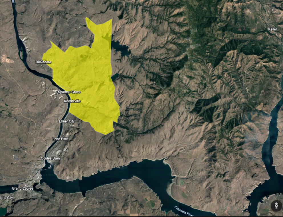
On the morning of July 24, 2024, the Colville Tribes Office of Emergency Management issued a Level 2 Evacuation (SET) for the area near Buffalo Lake and McGinnis Lake.
Miller Creek Fire Daily Update July 24 2024 07 24 2024
Related Incident:
Publication Type: News
KEY MESSAGE
Red Flag Warning issued for the Missoula area starting at noon today.
CURRENT STATUS
Crews and heavy equipment have been successful in creating a line around the entire fire perimeter. The Eastern side of the fire (Moccasin creek area) is currently the most active and lines in that area are plumbed with hose lays. Crews are also constantly monitoring for hot spots and being watchful for spot fires. The UAS (drone) is being used for reconnaissance and has been monitoring the fire area with infrared to pick up any new heat sources. The Southwest flank is being mopped up and is largely contained. Along the Northwest side of the fire, the line is plumbed with hose lays and there is no new heat.
WEATHER AND FIRE BEHAVIOR
Hot and dry conditions combined with gusty westerly winds and afternoon storms create critical fire weather conditions. Winds are forecasted to increase over the fire area over the next 24 to 36 hours. As a result of these conditions the fire location is under a Red Flag Warning by the National Weather Service starting at noon on Wednesday.
CLOSURES
A temporary flight restriction is in effect over the fire area. An area and road closure around the fire is in effect due to hazardous conditions resulting from fire activity. Stage II fire restrictions are in effect in the area. Specific closure information and maps are posted on InciWeb at https://inciweb.wildfire.gov/incident-information/mtlnf-miller-peak-fire and https://www.fs.usda.gov/alerts/lolo/alerts-notices as they are implemented.
Durkee and Cow Valley Fire Update 07 24 2024
Related Incident: Durkee FireCow Valley Fire
Publication Type: News
Durkee, Cow Valley, and Bonita Fires Update for Wednesday, July 24, 2024
541-208-4371, staffed 7AM to 7PM PDT
DURKEE FIRE: Start date: July 17, 2024 | Location: 5 miles southwest of Durkee, OR | Personnel: 526 | OSFM Task Forces: 4 | Fire size: 244,858 acres | Cause: Lightning | Containment: 0%
Today’s weather will lead to extreme fire behavior and growth. A Red Flag Warning has been issued for severe thunderstorms and will be followed by a Flash Flood Watch. Thunderstorm wind gusts may reach 75 mph and are expected to directly impact the Durkee Fire footprint. Burned areas are more susceptible to landslides, mudslides, flash floods and debris flow. The amount of rainfall is not known at this time, but 15/100 of an inch of precipitation in 15 minutes could be enough to cause debris flows.
The Malheur County Sheriff’s Office and the Baker County Sheriff’s Office have issued evacuations for multiple areas. Residents in Level 3 Evacuations “GO NOW”, should leave immediately. Residents should not return to their property until evacuation levels have been removed. Carry enough supplies to support you and your family for multiple days. A real time map of fire evacuations can be found at the State of Oregon Fire Dashboard.
Weather and fire behavior could impact transportation, power transmission, cell service and other utilities. Monitor these resources for additional information.
- Oregon Department of Transportation - TripCheck.com
- Idaho Power - IdahoPower.com
- American Red Cross of Eastern Oregon and Idaho - https://www.redcross.org/local/idaho.html
The Durkee Fire is located west of Interstate 84 (I-84). The Thompson Fire, a convergence of lightning fires that started near Thompson Creek on July 22, is located east of I-84. Both have grown rapidly with the persistent high temperatures, strong winds, and extremely dry fuels.
Firefighters worked overnight to maintain primary and secondary firelines and to support structure protection. No strategic firing operations were initiated. Today, wildland firefighters are anticipating the extreme weather event. They will remain strategically placed around the fire area for when the extreme weather arrives and engage when safe to do so. Protecting life of the public and firefighters is the highest priority of the incident.
Oregon State Fire Marshal task forces will work to support communities around the fire perimeter.
Yesterday, air resources were limited due to poor visibility and high winds. Air resources are expected to be limited or grounded today due extreme weather.
WEATHER AND SMOKE:
- RED FLAG WARNING
- FLASH FLOOD WATCH
- Thunderstorms with outflow winds as high as 75 mph
- For current smoke information, visit airfire.org.
EVACUATIONS AND CLOSURES:
The Malheur County Sheriff’s has issued evacuations for the area around Durkee Fire. check for updates on the Malheur County Sheriff’s Office Facebook page. There is an American Red Cross shelter in Ontario at the Malheur County Fairgrounds, 795 N.W. 9th Street.
The Baker County Sheriff’s Office has issued evacuations for the area around Durkee Fire. Visit the Baker County Sheriff’s Office Facebook page for more information. Baker County Sheriff's Office has closed Burnt River Canyon Road to non-local, non-emergency traffic due to the Durkee Fire.
I-84 AND OTHER HIGHWAYS: Please go to tripcheck.com for current road closures as the situation is dynamic and subject to change.
BURN BAN: A burn ban is currently in effect for all of Malheur County, including all BLM lands. For more information, visit https://www.malheurco.org/category/public-notices/.
TEMPORARY FLIGHT RESTRICTION: There is a temporary flight restriction over the Durkee Fire, please remember, if you fly we can’t! If a drone or other aircraft enters the air space, all firefighting aviation equipment will be grounded.
COW VALLEY FIRE: Start date: July 11, 2024 | Location: 9 miles east of Ironside, OR | Personnel:
0 | Fire size: 133,490 acres | Cause: Human caused |Containment: 91%
BONITA FIRE: Start date: July 11, 2024 | Location: 9 miles south east of Ironside, OR | Personnel: 0 | Fire size: 2,727 acres | Cause: Human caused |Containment: 90%
--
Durkee and Cow Valley Facebook Page
Hill Fire Morning Update 07 24 2024
Related Incident: Hill Fire
Publication Type: News
HILL FIRE INCIDENT UPDATE
Date: July 24, 2024
Fire Information: 530-414-9056
Hours: 08:00 AM to 8:00 PM
Email:2024.Hill@firenet.gov
Incident Website:
https://inciweb.wildfire.gov/incident-information/casrf-hill-fire
https://www.fire.ca.gov/incidents/2024/7/16/hill-fire
Location: Humboldt County, CA
Size: 6623 acres
Cause: Under Investigation
Start Date: Monday July 15, 2023, at 5:40 PM
Percent contained: 10%
Personnel: 2075
Community Meeting tonight 7/24/24 at 7:00 PM at Willow Creek Bible Church
39 Brannon Mountain Rd., Willow Creek, CA
CURRENT SITUATION:
Yesterday, as local temperatures increased, firefighters worked tirelessly on the Hill Fire. On the southern perimeter, constructed lines held, and additional depth was achieved by focusing on areas of unburned fuel.
Along the western and northern edges, crews diligently monitored previously contained areas and conducted mop-up operations to address hotspots. Crews connected handlines surrounding pockets of heat north of the fire, with ongoing efforts to extinguish these areas in the coming days fully.
Spotting was observed on Sugarloaf Mountain, prompting firefighters to strategically reposition resources to work on containment. Crews are working the spot fire from the north and south, with the support of aircraft, and actively engaging the fire directly to achieve containment.
Today, crews and air resources continue to focus directly on the spot fire located on Sugarloaf Mountain. Meanwhile, on the west side, crews are engaged in mop-up operations and patrolling the area to ensure containment.
There will be a community meeting tonight at the Willow Creek Bible Church at 7:00 PM.
WEATHER:
A passing upper-level shortwave will help ease heat today and slightly increase relative humidity. Expect smoke to lift more than previous days with inconsistent smoke transport out of the area. Winds will battle from southeast in the morning to west in the afternoon, with infrequent and inconsistent gust up to 20 mph. Winds will be heavily terrain influenced. A slight chance of thunderstorms will continue through the early afternoon with any storms most likely to be dry, isolated, and fast moving.
EVACUATIONS:
Evacuation order and warnings remain in effect. For current updates on evacuations, visit https://www.facebook.com/HumboldtSheriff and https://humboldtgov.org/2383/Current-Emergencies.
Conditions are subject to change at any time, visit https://protect.genasys.com/search for a full zone description.
Sign up for Humboldt Alert emergency notifications at https://humboldtgov.org/2014/Emergency-Notifications
CLOSURES:
Forest Closure Order currently in effect for the area impacted by the Hill Fire. It is temporarily prohibited to be on any national forest system land, trail, or road within the closure area. To view the closure order and map of closure area visit the following link www.fs.usda.gov/Internet/FSE_DOCUMENTS/fseprd1191963.pdf.
Road closures are currently in place on Friday Ridge Rd. at Forest Service Route 6N06, Friday Ridge Rd. at Forest Route 5N01 and Friday Fridge Rd. at Forest Route 5N04. For updated road closure information, visit protect.genasys.com or humboldtsheriff.org/emergency.
FIRE RESTRICTIONS:
Forest fire restrictions also went into effect on July 12th. Campfires and stove fires are restricted to those developed areas listed in the forest order located at https://www.fs.usda.gov/Internet/FSE_DOCUMENTS/fseprd1188610.pdf.
Smoking, welding, and operating an internal combustion engine also have restrictions in place.
Shelly Fire Morning Update 07 24 2024
Related Incident: Shelly Fire
Publication Type: News
Location: Siskiyou County, CA Start Date: Wednesday July 3, 2024 at 1:27 PM
Size:15,477 acres Percent Contained:62%
Cause: Under Investigation Personnel:1,717
CURRENT SITUATION:
The fire’s behavior is expected to stay largely the same today. Areas around Kidder Creek and Patterson Creek may produce smoke as the fire finds unburnt pockets of fuel. Crews will be focusing on fire suppression repair work to rehab roads and trails that may have been impacted by suppression efforts. To this point, 49% of bulldozer lines have been repaired and inspected.
While Shelly Fire operations is reducing the number of personnel and equipment, the safety of the community remains paramount.
Drivers in the area should remain alert for fire personnel and heavy equipment on or near the roadways.
WEATHER:
Today brings a 30% chance of thunderstorms along with outflowing winds that may influence fire behavior, while not testing containment lines.
EVACUATIONS:
For current evacuation status, visit www.facebook.com/SiskiyouCountySheriff and www.facebook.com/SiskiyouCountyOES. Additional evacuation information and a map can be found on the Genasys site at https://protect.genasys.com/search?z=14&latlon=41.550694%2C-122.905589.
CLOSURES:
An official forest closure around the Shelly Fire went into effect on July 4th. Hikers are not permitted and will be asked to leave the area. For details and a map of the closure area, please visit https://www.fs.usda.gov/Internet/FSE_DOCUMENTS/fseprd1187463.pdf.
FIRE RESTRICTIONS:
Forest fire restrictions are currently in effect. Campfires and stove fires are restricted to those developed areas listed in the forest order at https://www.fs.usda.gov/alerts/klamath/alerts-notices/?aid=88596. Smoking, welding, and operating an internal combustion engine also have restrictions in place.
Pacific Crest Trail Information: https://www.pcta.org/discover-the-trail/closures
Texas Fire Current as of 07 24 2024
Related Incident: Texas Fire
Publication Type: News
Texas Fire – FINAL Update
July 24, 2024, 8:30 AM PT
Date of Origin: Monday, July 15, 2024
Location: East of Kendrick, Idaho
Cause: Human
Size: 1,582 acres Containment: 80% Personnel: 114
Northern Rockies Team 8 will transfer command of the Texas Fire back to the Idaho Department of Lands Thursday, July 25th at 6:00 AM PT. Robbie Easley, a local Type 4 Incident Commander will assume command of the fire along with approximately 50 firefighters.
Current Situation:
Approximately 50 firefighters, including 2 crews, 2 engines, and 1 water tender will remain on the incident and continue to patrol the fire area. Firefighters will check on visible smokes and take necessary actions to stop further fire spread.
Please be mindful of firefighters still working and driving within the fire area. Slow down for your safety and theirs.
Weather: Today, cooler temperatures are expected in the low 90’s. There is a 25% chance for scattered showers and thunderstorms after 3:00 PM PT, with potential for gusty, erratic winds between 20-30 mph. Thursday, a mostly dry cold front will bring an increase in west to southwest winds sustained around 10 mph.
***This will be the last update for the Texas Fire unless conditions change.***
Fire Restrictions: Stage 1 Fire Restrictions are in effect for the Grangeville Fire Restrictions Area. Restrictions apply to all federal, state, state endowment, private forestland, and rangelands within the designated area.
InciWeb: https://inciweb.wildfire.gov/incident-information/idids-texas-fire
###
Settings - change map background and toggle additional layers
Filter - control incident types displayed on map.
Zoom to your location
Reset map zoom and position
Could not determine your location.
Show Legend
 Wildfire
 Prescribed Fire
 Burned Area
Response
Burned Area
Response Other
Other
Badland Complex 2024
Unit Information
Incident Contacts
Blacktail Canyon Morning Update 07 24 2024
Related Incident: Blacktail Canyon
Publication Type: News
Incident Commander J. Willoughby
Location: southeast of Butte, MT between Interstate 90 and Highway 2
Start Date: 7/19/2024
Cause: Undetermined
Size: 80 acres
Resources on Site: 3 engines, 1 helicopter, 2 type 1 “hotshot” hand crews, 4 type 2 hand crews
Total Personnel Assigned: 160
KEY MESSAGES:
The evacuation warning issued by Butte-Silver Bow Law Enforcement Department for Blacktail Canyon Road southeast of Homestake Road, Homestake Road east of Blacktail Canyon Road, and Passmore Canyon is still in effect.
A RED FLAG WARNING will be in effect today. The combination of low relative humidity and thunderstorm outflow winds will result in critical fire weather conditions. These conditions increase the risk for new and existing fires to spread quickly. Winds will be from the southwest at 10-15 mph, and gusts associated with thunderstorms may reach 30 mph. Relative humidity will bottom out at 12-17 percent. Fire officials are keeping a close tab on these conditions, as they affect fire behavior and subsequent firefighting operations. Securing the fire edge is paramount, in anticipation of the cold front passage with gusty southwest winds on Thursday.
The combination of these weather conditions, the volume of fuel in and adjacent to the fire area, and the amount of internal residual heat result in significant potential for this fire. Winds associated with passing thunderstorms will test the efficacy of constructed firelines. The public is advised to stay out of the area, as crews and helicopters continue their work. Ensuring firefighter safety and protecting life and property are of the utmost importance during any incident.
CURRENT STATUS/PLANNED ACTIONS:
“Drones” were used for more precise infrared mapping operations, placing the fire at 80 acres. Helicopters assisted ground operations with reconnaissance flights and sling loads of cargo.
Residual heat is still present in the smoldering fuels throughout the fire footprint. Crews progressed with “mop-up” operations, working along the previously constructed sawline and handline. Crews canvassed the ground along the fire edge and one chain (66 feet) into the interior, locating and extinguishing hot spots. Crews were able to complete these “mop-up” operations along approximately 40% of the fire footprint so far. Crews will continue these operations, expanding along both flanks of the fire and working toward 100% completion of the “mop-up” objectives. Engine crews and helicopters will be available for initial attack of new fires in the area, given the predicted weather conditions.
Helicopters will be available for aerial support with bucket drops and movement of cargo through “sling loads.”
WEATHER AND FIRE BEHAVIOR
Fire behavior was moderate yesterday, with smoldering and creeping observed, despite the hot and dry conditions. Larger fuels continue to consume, producing small areas of smoke interior to the fire’s edge.
Winds will be from the south, switching to the southwest at 10-15 mph, and erratic gusts associated with thunderstorms may reach 30 mph. Relative humidity will bottom out at 12-17 percent. Temperatures will remain in the upper 80s to low 90s. Increased winds and dry thunderstorms enter the area, as the ridge of high pressure breaks down and a cold front moves through on Thursday. Little to no precipitation is expected.