
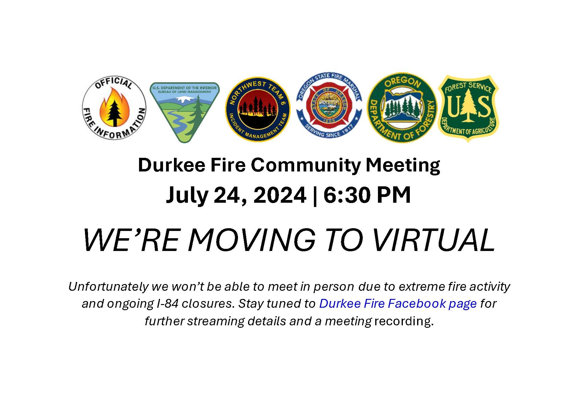
Community Meeting July 24 Moved to Virtual Only 07 23 2024
Related Incident: Durkee Fire
Publication Type: Announcement
Unfortunately we won’t be able to meet in person due to extreme fire activity and ongoing I-84 closures. Stay tuned to Durkee Fire Facebook page for further streaming details and a meeting recording.
Settings - change map background and toggle additional layers
Filter - control incident types displayed on map.
Zoom to your location
Reset map zoom and position
Could not determine your location.
Show Legend
 Wildfire
 Prescribed Fire
 Burned Area
Response
Burned Area
Response Other
Other
Microwave Tower Fire
Unit Information
Incident Contacts
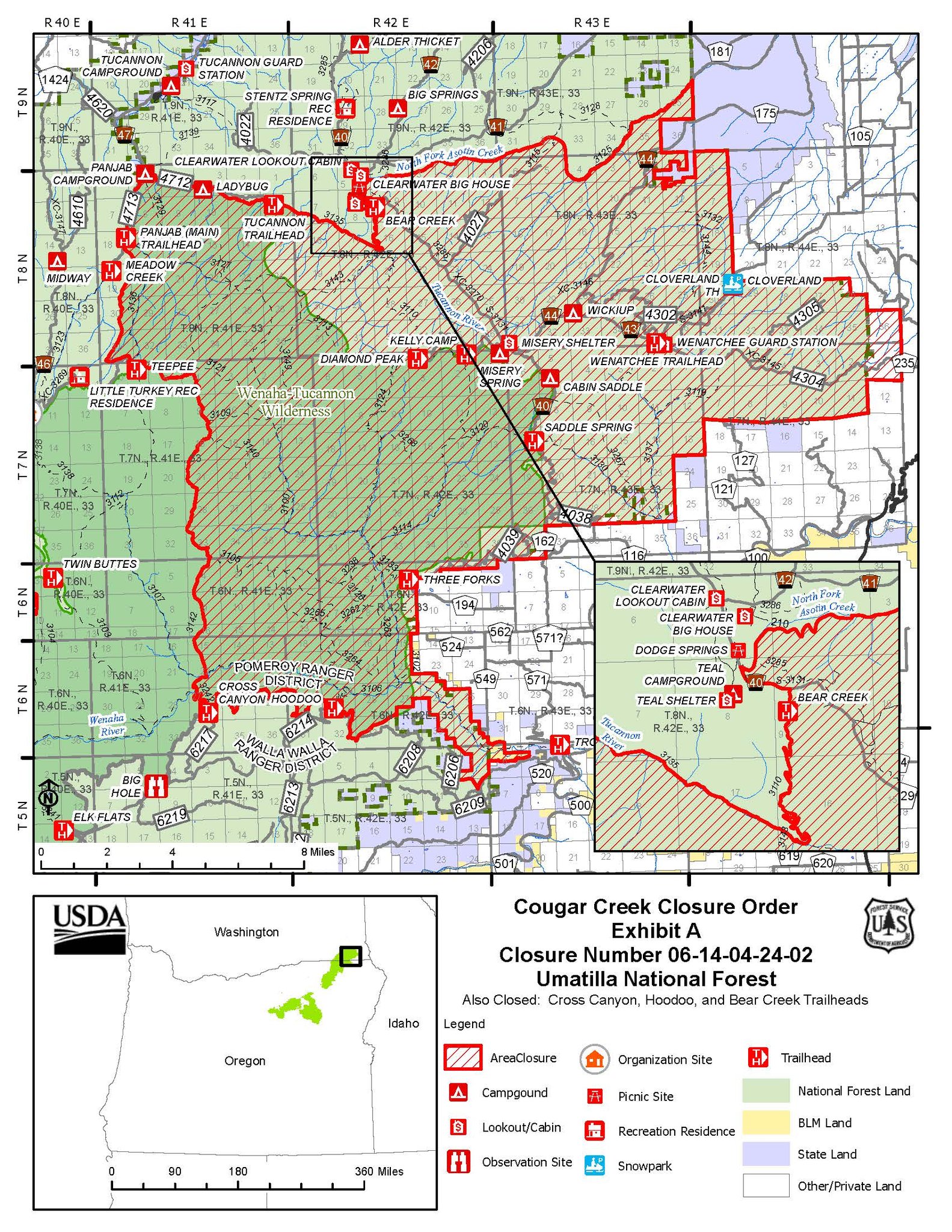
Cougar Creek Fire Closure Order No 0614042402 07 23 2024
Related Incident: Cougar Creek Fire
Publication Type: Closures

Umatilla National Forest July 22 Fire Update
Fire Update (3:00 p.m.)
Multiple fire related area closures are in effect for the Umatilla National Forest including areas on the Heppner, North Fork John Day, and Pomeroy Ranger District. Closure descriptions and maps are available at https://www.fs.usda.gov/detail/umatilla/alerts-notices/?cid=stelprdb528676.
Actualizacin del incendio Easy 07 23 2024
Related Incident: Easy Fire
Publication Type: News
Actualización del incendio Easy
23 de julio de 2024
Datos clave:
Tamaño: 354 acres Fecha de inicio: 17 de julio de 2024 Ubicación: 17 millas al oeste de Mazama, WA
Contención: 0% Personal: 30 Causa: Rayo
Recursos asignados: 1 equipo, 3 helicópteros, 3 camiones de bomberos
SITUACIÓN ACTUAL: El incendio Easy arde sobre una cantidad densa de restos de madera con abundantes árboles muertos y una extensa área de vegetación. El terreno tiene una inclinación extrema. Las continuas condiciones meteorológicas inestables, cálidas y secas del lunes provocaron un aumento en la intensidad del incendio que incluye incendios aislados o desplazamiento del fuego desde el suelo hasta las copas de los árboles. Los pequeños focos aislados, en los que las brasas llegan al frente del incendio, también han contribuido a la propagación. El incendio Easy se extiende sobre el Mt. Hardy y amenaza el Pacific Crest Trail (PCT), mientras que se desplaza colina abajo hacia la ruta estatal 20 (SR 20) de la autopista North Cascades.
Mientras las empinadas colinas contribuyen con las actividades de extinción, los equipos emplean tácticas de extinción total que tienen las mayores probabilidades de éxito y minimizan los riesgos para los bomberos y el público.
Desplazamientos de piedras, árboles caídos y el incendio activo cerca de la carretera obliga al cierre de la SR 20 para proteger al público de los peligros asociados con el comportamiento del incendio y las estrategias de extinción. Los equipos talan árboles muertos entre el extremo activo del incendio y la ruta estatal 20 para ayudar a limitar su propagación hacia la carretera.
El lunes, los helicópteros ayudaron a los bomberos vertiendo agua para ralentizar la propagación del incendio Easy. Asimismo, los equipos se encuentran estableciendo activamente líneas de control e instalando sistemas de rociadores.
ACTIVIDADES DE HOY: La extrema geografía del terreno evita el ataque directo sobre el incendio Easy. Los bomberos seguirán con la identificación y mejora de los cortafuegos indirectos que aprovechan las barreras naturales, como rampas de avalanchas y zonas quemadas por incendios pasados. Los equipos terrestres continuarán talando árboles muertos por encima y a nivel paralelo de la ruta estatal 20 para reducir los peligros y eliminar la vegetación que sirve como combustible para el incendio. Los bomberos refuerzan las líneas de control y siguen vertiendo agua sobre el incendio. Además, es posible que comiencen las obras de protección de estructuras de la histórica torre Mebee Lookout.
CLIMA: Anoche, una capa marina del oeste trajo consigo humedad a la zona del incendio. El aire justo encima de la capa marina es seco, así que las condiciones cambiarán durante el día a medida que se mezclan. Con las temperaturas más frescas, se esperan ráfagas de viento fuerte hasta con una velocidad de 26 millas por hora.
EVACUACIONES: No existen órdenes de evacuación para el incendio Easy. Cualquiera que utilice la zona para recrearse debe estar atento a su entorno y permanecer fuera de las áreas cerradas. Visite https://t.ly/QoH9w para tener más información sobre los niveles de evacuación.
CIERRES: La ruta estatal 20 se encuentra cerrada en ambas direcciones entre Granite Creek (MP 148) y Easy Pass Trailhead (MP 157).
El Bosque Nacional Okanogan-Wenatchee tiene órdenes de cierre en los senderos dentro del área afectada por el incendio: https://bit.ly/EasyFireClosures. Las fogatas están prohibidas. Hay una restricción temporal de vuelo (TFR, en inglés) sobre el área del incendio: https://tfr.faa.gov/save_pages/detail_4_6779.html.La actividad de drones no autorizados está prohibida por la TFR.
InciWeb: https://inciweb.wildfire.gov/incident-information/waowf-easy-fire
Facebook: https://www.facebook.com/profile.php?id=61560760893080
Línea de información sobre el incendio: 541-861-5808, de 8 AM a 8 PM
Correo electrónico: 2024.pioneer@firenet.gov
Actualizacin diaria del incendio Pioneer 23 de julio de 2024 07 23 2024
Related Incident:
Publication Type: News
Actualización diaria del incendio Pioneer
23 de julio de 2024
Datos clave:
Tamaño: 30,667 acres Fecha de inicio: 8 de junio de 2024 Ubicación: 31 millas al NO de Chelan, WA
Contención: 14% Personal: 732 Causa: De origen humano, a ser determinada
Recursos asignados: 12 equipos, 7 helicópteros, 27 camiones de bomberos, 28 tanques de agua, 18 maquinarias pesadas
Se realizará una reunión comunitaria en Stehekin el martes a las 5 PM en el centro de visitantes Golden West. Asimismo, se realizará una reunión comunitaria en Manson el miércoles a las 5:30 PM en la preparatoria Manson High School. La reunión de Manson también será transmitida en directo en la página de Facebook sobre información del incendio Pioneer. Agradecemos que envíen sus preguntas por adelantado al correo 2024.pioneer@firenet.gov o a través del Messenger de Facebook.
SITUACIÓN ACTUAL: Los bomberos y equipos del programa Asistencia estatal contra incendios llegaron a Stehekin para implementar planes de protección de estructuras. A pesar de que frente frío que se desplazó por la región el lunes trajo humedad más baja y ráfagas de viento hacia el río, el crecimiento del incendio fue mínimo. Durante los próximos días podrían reavivarse los focos de calor restantes y aparecer nuevos brotes dentro de la zona de East Fork de la cuenca Prince Creek, en la cuenca de Fish Creek y alrededor de Cub Lake. En el extremo sur del incendio, los bomberos buscan focos de calor en la cuenca de Lone Fir y a lo largo de los cortafuegos mejorados en Nelson Ridge y Coyote Ridge. Asimismo, los bomberos del incendio Pioneer ofrecieron una respuesta inicial a nuevos incendios forestales que comenzaron en el área el día lunes.
ACTIVIDADES DE HOY: El personal de infraestructura en Stehekin trabajará con el equipo estatal especial para mejorar el refuerzo de viviendas y de los espacios defendibles en estructuras e infraestructuras. Al norte del incendio, los bomberos construirán una línea de "comprobación" justo al sur de Flick Creek que estará vinculada a rasgos rocosos naturales. Esta línea de comprobación ayudará a retrasar la progresión del incendio en la costa del lago. Sin embargo, debido a la gran cantidad de combustibles pesados y a la inclinación del terreno que lo hace inaccesible, no se espera que esta maniobra detenga por completo la propagación del incendio. Al mismo tiempo, los bomberos monitorean y neutralizan los focos de calor en la costa del lago. Los equipos seguirán mejorando los cortafuegos directos en Cooper Ridge y Antilon Ridge, al norte de Manson. La cuenca de Lone Fir sigue bajo monitorización para detectar focos de calor.
CLIMA: Gracias al frente frío que pasó ayer, las temperaturas serán más frescas, pero los vientos sobre el incendio seguirán siendo fuertes. La bandera roja de advertencia se extiende hasta hoy debido a que se esperan ráfagas de viento y humedad baja. Se espera que se intensifique el comportamiento activo del incendio y de las llamas internas aisladas por la crítica situación meteorológica. Existe la posibilidad de ver columnas de humo.
EVACUACIONES: Los niveles 1, 2 y 3 de evacuación alrededor del incendio Pioneer no han cambiado. Visite https://t.ly/QoH9w para tener más información.
CIERRE DEL BOSQUE: Cierres vigentes del Parque nacional North Cascades: https://www.nps.gov/noca/index.htm
El Bosque Nacional Okanogan-Wenatchee ha emitido una orden de cierre sobre gran parte del área afectada por el incendio: https://bit.ly/PioneerClosure. Las fogatas están prohibidas. Hay una restricción temporal de vuelo (TFR, en inglés) sobre el área del incendio: https://tfr.faa.gov/save_pages/detail_4_6779.html. La actividad de drones no autorizados está prohibida por la TFR.
InciWeb: https://inciweb.wildfire.gov/incident-information/wases-pioneer
Facebook: https://www.facebook.com/profile.php?id=61560760893080
Línea de información sobre el incendio: 541-861-5808, de 8 AM a 8 PM
Correo electrónico: 2024.pioneer@firenet.gov
Whisky Creek Fire Daily Update 07 23 2024
Related Incident: Whisky Creek Fire
Publication Type: News
Start Date: July 20, 2024
Fire size: 151 Acres
Cause: Human, under investigation
Containment: 0%
Whisky Creek Fire is located five miles southeast of Cascade Locks, OR and is within the Mark O. Hatfield Wilderness. An infrared flight last night mapped the fire at 151 acres. Fire managers use infrared technology to detect heat and help track fire growth.
Crews made great progress clearing Gorton Creek Trail #408 yesterday. Today they will continue to improve Trail #408 then move to work on Herman Creek Trail #406 and Green Point Ridge Trail #418. Resources on the south end of the fire were able to locate an area to put in a potential direct handline along the south end of the fire and will continue to scout the area today.
The weather forecast today will be similar to yesterday but with reduced wind speeds in the Columbia River Gorge. The fire was sheltered from the yesterday’s high winds and experienced minimal growth.
Because of minimal fire behavior yesterday, Whisky Creek air resources were able to support a new fire start west of Mosier, OR where there was immediate threat to life and safety.
Great Basin Complex Incident Management Team #6 arrived yesterday evening. They will use today to shadow the Type 3 resources and will assume command tomorrow morning, Wednesday, July 24.
The Mt. Hood National Forest and the Columbia River Gorge National Scenic Area are issuing a joint emergency closure for the fire area.
Closures:
• Developed Recreation Sites: Rainy Lake Campground, Black Lake Campground, Wahtum Lake Campgrounds, Indian Springs Trailhead, Warren Lake Trailhead, Wahtum Lake Trailhead, Mt. Defiance South Trailhead, Wyeth Trailhead, and Herman Creek Trailhead
• Trails: Gorge #400, Herman Creek #406, Herman Bridge #406E, Gorton Creek #408, Wyeth #411, Green Point Ridge #418, Deadwood #422, North Lake #423, Rainy Lake #423A, Ridge Cut-off #437, and Nick Eaton #447
• Roads: Forest Service Roads: 1310, 1310-640, 1310-641, 1310-660, 1310-661, 1310-662, 1310-664, 1310-669, 2810, 2810-630, 2810-650, 2820 beginning at its junction with Forest Service Road 2820-620, 2820-011, 2820-013, 2820622, 2820-631, 2820-632, 2820-633, 2820-634, 2820-635, 2820-636, 2820-650, 2820-651, 2820-660, 2820-661, 2820-662, 2820-663, 2820-670, 2820-685, 2821, 2821-620, 2821-621, 2821-630, and 2821-640
The cause of the fire is from human activity and is currently under investigation. The public is reminded that fire restrictions are in effect and campfires are prohibited across both Mt. Hood National Forest and Columbia River Gorge National Scenic Area lands.
Bridge Creek Daily Update July 232024 07 23 2024
Related Incident: Swawilla Fire
Publication Type: News
News Release – July 23, 2024
Bridge Creek Fire
Firefighters worked in extreme heat and moderate winds over the past few days to increase containment on the Bridge Creek fire. Using hand tools, large equipment and a helicopter. The fire pushed hard to the south and crossed the Bridge Creek road in a few locations, moving into dry grass and light fuels. Fire managers expect limited fire growth on this fire Tuesday, which will give firefighters the opportunity to shore up dozer and control lines around it in preparation for the dry cold front and winds arriving on Wednesday.
A bulldozer did roll over in rough terrain on the southwest side of the fire on Monday and fortunately, the driver walked away with minimal injuries.
Several roads have been closed in the fire area to keep both the firefighters and the public safe during wildfire suppression:
Bridge Creek Rd
Keno Mine Rd
Upper Bridge Creek Rd
SanPoil Rd
30 Mile Road
FIRE ACTIVITY: The weather remains unseasonably hot and dry and a dry cold front is predicted on Wednesday, which will bring strong winds to the fire. Firefighters are taking advantage of roads and topographic features (ridges, roads, streams) to build strong lines in preparation for this change in weather. Fire crews are working both day and night as needed to take advantage of more favorable fire behavior and working conditions. A helicopter is supporting ground crews with bucket drops on hotter areas.
In addition to the Bridge Creek Fire, there are two other fires burning in this region. The Swawilla Fire is expected to be the most active of the fires. Please refer to the Swawilla Fire update for more information on road closures, evacuations and other information related to that fire. This will be the last independent update on the Bridge Creek Fire. It will be included in the Swawilla Fire update in the future
PUBLIC AND FIREFIGHTER SAFETY IS THE NUMBER ONE PRIORITY.
Willamette National Forest implements fire restrictions 07 23 2024
Related Incident: Willamette Complex Fires - SouthNorth Willamette Complex
Publication Type: Announcement
https://www.fs.usda.gov/detail/willamette/news-events/?cid=FSEPRD1191891
Willamette National Forest implements fire restrictions
Release Date: Jul 17, 2024
Contact(s): Carla Robinson
Open fires prohibited as Industrial Fire Precaution Level increases
Springfield, OR – July 17, 2024 – As hot, dry temperatures and red flag warnings continue, the Willamette National Forest will implement fire restrictions and increase the Industrial Fire Precaution Level (IFPL) to IFPL II. The new restrictions are in effect starting July 17, 2024, until rescinded. The Fire Danger Level across the forest remains “HIGH”.
All campfires, charcoal or briquette fires, pellet fires, or any other open fires will be prohibited outside of designated campgrounds under Forest Order #06-18-00-24-12. Building, maintaining, or using a fire, campfire or stove fire is authorized in designated metal campfire rings or grills in designated recreational sites, except when the site is closed to the public.
Portable cooking stoves and lanterns using liquefied or bottled fuel are still allowed as they can be instantly switched off. Generators are permitted only in areas devoid of vegetation, such as campground pavement. Motorized vehicles may operate only on designated trails and roads.
Restrictions will also go into effect for smoking, off-highway vehicles, and chainsaws in campgrounds. Smoking is not allowed except within an enclosed vehicle, building, or a developed recreation site. Additionally, welding or operating an acetylene or other torch with open flame is also not allowed.
The increase to IFPL II limits the following operations to the hours between 8 p.m. and 1 p.m.: power saws except at loading sites; feller-bunchers with rotary head saws; cable yarding; blasting; and welding, cutting, or grinding of metal.
Please be aware of current restrictions and share information with others who may be unaware of the restrictions. As fire restrictions change, information will be made available at https://www.fs.usda.gov/main/willamette/fire.
Follow us on Facebook and Twitter @WillametteNF for the latest updates. https://www.fs.usda.gov/willamette/
To report a wildfire, please call 9-1-1.
Settings - change map background and toggle additional layers
Filter - control incident types displayed on map.
Zoom to your location
Reset map zoom and position
Could not determine your location.
Show Legend
- Wildfire
- Prescribed Fire
- Burned Area
Response
- Other
Whisky Canyon Fire
Unit Information
Incident Contacts
Update Containment Increases 07 23 2024
Related Incident: Mestenas Canyon Fire
Publication Type: News
Crews on Monday continued to build control lines and conducted more firing operations on the Mestenas Canyon Fire, which has grown to 628 acres with 30% containment.
Containment was gained on the fire’s southern edge, and a ¾-mile stretch of Forest Road 312 was blacklined, which is when fire personnel burn fuels along a control line ahead of an approaching fire.
“Despite the complicated location of where this fire started, our progress is looking good,” said District Ranger Jim Eaton, referring to point of origin where lightning ignited the incident in a steep canyon rife with dangerous snags.
There are no evacuations, but oil and gas infrastructure, archeological sites, dispersed camping areas and inholdings may be threatened if the fire grows beyond planned control lines.
The lightning-caused Mestenas Canyon Fire was first reported July 11. It is in the canyon of the same name, about 14 miles southwest of Dulce, N.M., and two miles north of Highway 64, where smoke may cause limited visibility to drivers.
The public can keep updated on the fire by visiting InciWeb or calling a public information officer at 505-216-6793.