
Easy Fire Update 07 24 2024
Related Incident: Easy Fire
Publication Type: News
Easy Fire Update for July 24, 2024
Incident Commander Lonnie Click
Complex Incident Management Team Northwest 3
(541) 861-5808, staffed 8 a.m. to 8 p.m. 2024.pioneer@firenet.gov
Quick Facts
Size: 397 acres
Start Date: July 17, 2024
Location: 17 miles west of Mazama, WA
Containment: 0%
Personnel Assigned: 118
Cause: Lightning
Resources Assigned: 3 crews 3 engines
CURRENT SITUATION: Cooler temperatures on Tuesday reduced fire behavior and overall fire growth on the Easy Fire in the morning. Fire activity increased Tuesday night producing single and group tree torching along with a visible plume of smoke. The fire is burning in extremely steep terrain with large dense timber, abundant dead trees and ground vegetation. The fire continues to move slowly down slope towards State Route 20 (SR 20) North Cascades Highway.
Yesterday, helicopters continued to assist firefighters with water bucket drops to slow the spread of the fire. Crews set up structure protection sprinkler systems around Easy Pass Trailhead and established sites to provide water for containment line hoses. Firefighters also constructed containment lines connecting into a previous burn scar on the northern side of the Easy Fire. Rolling rock, falling trees, and active fire near the highway continues to necessitate a closure on SR 20 to protect the public from hazards associated with fire behavior and suppression tactics. Crews are felling dead trees between the active fire edge and SR 20 to reduce the fire spread toward the highway.
TODAY’S ACTIVITIES: Firefighters will bolster the indirect fireline on the northern section of Easy Fire. Crews may conduct chipping operations to remove fallen trees across State Route 20. Additionally, firefighters will continue felling dead trees above and parallel to State Route 20 which will help with removing hazards to the highway.
WEATHER: Temperatures tomorrow will continue to cool with highs in the high 80s and low 90s with mild Northwest winds around 6mph. Today will be drier then yesterday, however it is expected cooler and moist air will move over the fire tomorrow.
EVACUATIONS: There are no evacuations in place for the Easy Fire. Anyone recreating in the area should be vigilant about being aware of surroundings and stay out of closed areas. Please visit https://t.ly/QoH9w for more information about evacuation levels.
CLOSURES: State Route 20 is closed in both directions between Granite Creek (MP 148) and Easy Pass Trailhead (MP 157).
The Okanogan-Wenatchee National Forest has closures in place for trails within the fire area: https://bit.ly/EasyFireClosures. This closure includes a portion of the Pacific Crest Trail. Campfires are prohibited. There is a Temporary Flight Restriction (TFR) in place over the fire: https://tfr.faa.gov/save_pages/detail_4_6779.html. Unauthorized drone activity is prohibited under the TFR.
Facebook: https://www.facebook.com/profile.php?id=61560760893080
Fire Information Line: 541-861-5808, 8 AM to 8 PM
Email: 2024.pioneer@firenet.gov
Oakridge Lightning Fires 2024 Daily Update Wednesday 07 24 2024
Related Incident: Willamette Complex Fires - South
Publication Type: News
Fire Update – Oakridge Lightning Fires
Chalk, Coffeepot, McKinley, Moss Mountain, Tire Mountain, 208, and 217 Fires
Wednesday, July 24, 2024 – 10:00 a.m.
Rocky Mountain Complex Incident Management Team 1
Dan Dallas, Incident Commander
Information Phone: (541) 208-1742
Email:2024.mossmountain@firenet.gov
Information Staffing Hours: 8 a.m. to 8 p.m.
Special Note: This update covers seven wildland fires on the Willamette National Forest being managed by the Rocky Mountain Complex Incident Management Team 1 (CIMT1). The Team assumed command of the fires on Tuesday, July 23, 2024. We thank the Willamette National Forest and initial attack firefighters for setting us up for success as we continue working to suppress these fires.
Current Situation: Suppression activities are underway on fires deemed the highest priority, namely the Chalk, Coffeepot, and Moss Mountain Fires. Additional resources have been requested to bolster suppression efforts, however, with 38 large fires in Oregon alone, resources for fire suppression are extremely limited and are being prioritized carefully statewide. An infrared flight occurred on Tuesday and has provided incident management staff a more accurate assessment of fire perimeters. Coordination of suppression activities with local, state, and industry representatives is ongoing. Information about the fires and our suppression activities is available daily through these updates, social media, InciWeb, and community information boards. The following fire information is listed in order of suppression priority.
Chalk Fire (2,427 acres, 0% contained) – Tuesday’s infrared flight shows that the Chalk Fire’s perimeter has grown by approximately 1,000 acres to its current 2,247 acres. The Chalk Fire is burning in a mixture of continuous fuel, all of which are receptive to fire. Existing roads and previous fire breaks are being used to build containment line. Mechanized equipment is being used to support control efforts on the main part of the fire. The Chalk Fire abuts the 2021 Gales Fire scar, which will slow its progress and assist with control.
Coffeepot Fire (613 acres, 0% contained) – Activity on the Coffeepot Fire increased on Tuesday due to strong winds aligning with steep, rugged terrain. An airtanker supported efforts yesterday on the Coffeepot Fire to attack the fire.
Moss Mountain Fire (168 acres, 0% contained) – The fire is threatening the Wolf Mountain communications site. Firefighters and heli-rappelers are working to contain the fire edge with some success. Firefighters will also tie the fire into existing fire footprints in the area will also be used to limit fire spread.
208 Fire (112 acres, 0% contained) – This fire is entirely within the Diamond Peak Wilderness and while it is spreading with moderate growth, it does not currently present a threat to high values at risk. The Pacific Crest Trail, which runs near this fire, is closed within the Wilderness.
217 Fire (32 acres, 0% contained) – This fire is also within Diamond Peak Wilderness and is threatening to spread outside the Wilderness boundary on its north flank. The fire is being assessed for future actions.
Tire Mountain Fire (20 acres, partially contained) – This fire is in steep old growth timber on a north slope and is accessible to smaller engines by road. Firefighters have made good progress constructing fireline on the west and south sides. Containment is expected in the near term.
McKinley Fire (26 acres, partially contained) – In steep terrain south of the 19 Road. Containment is anticipated in the near term.
Weather and Fire Behavior:
A northwest air flow is establishing with seasonal temperatures. Nighttime temperatures are dropping to 45-55 degrees with relative humidity of 60-80%. An inversion over the area this morning has held smoke at ground level. The inversion will break around 1:00 pm, allowing temperatures to rise to 70-80 degrees and humidity to lower to 35-40%. These conditions will contribute to increasing fire activity in the afternoon, with potential for spotting and increased rates of spread.
Evacuations:
There are no evacuations in place at the present time.
Closures and Fire Restrictions:
Area, road, trail, and recreation site closures are in place on the Willamette National Forest in the vicinity of many active fires. For specific information follow this link: https://www.fs.usda.gov/detail/willamette/alerts-notices/?cid=fseprd552029
Fire restrictions on the Willamette National Forest may be found at this link: https://www.fs.usda.gov/alerts/willamette/alerts-notices/?aid=81487
Wildfires are a no-fly zone for unauthorized aircraft, including drones. If you fly, we can’t. For more information, visit http://knowbeforeyoufly.org.
Fire Statistics:
Size and Containment: See below
Total Personnel: Over 400
Location: N & S of Oakridge, OR
Reported: Various
Cause: Lightning
For More Information:
Information Phone:
(541) 208-1742
Email:
2024.mossmountain@firenet.gov
InciWeb:
https://inciweb.wildfire.gov/incident-information/orwif-oakridge-lightning-fires-2024
Facebook:
https://www.facebook.com/OakridgeLightningFires2024/
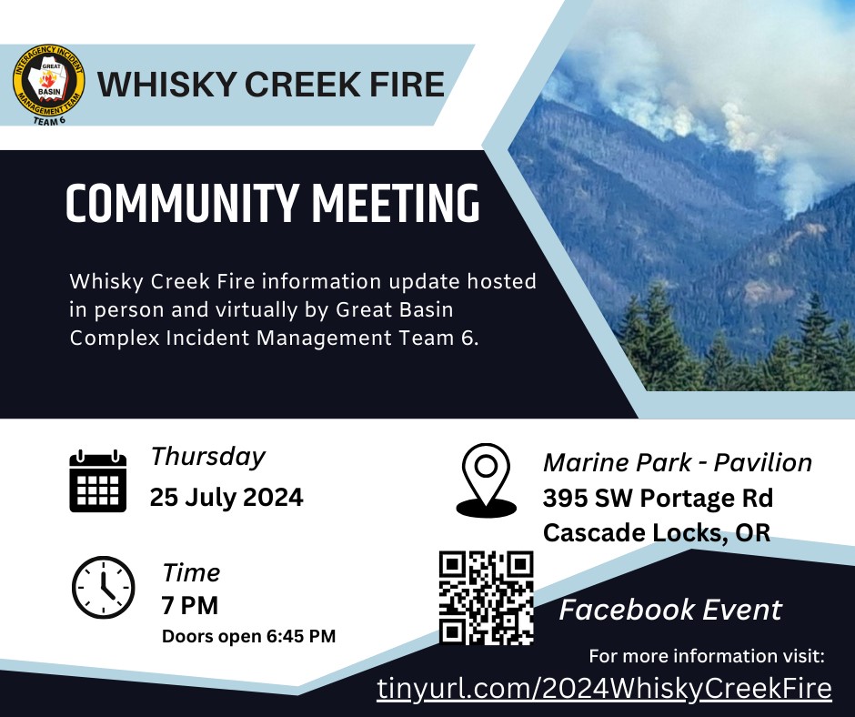
Whisky Creek Fire Community Meeting Thursday July 25 7 PM the Marine Park Pavilion 07 24 2024
Related Incident: Whisky Creek Fire
Publication Type: Announcement
Whisky Creek Fire Community Meeting - Thursday, July 25, 7 PM @ the Marine Park Pavilion in Cascade Locks.
Whisky Creek Fire information update hosted in person and virtually by Great Basin Complex Incident Management Team 6.
Recording available here: https://www.facebook.com/2024WhiskyCreekFire/videos/1193012498557631
Ore Fire Update 07 24 2024
Related Incident: Ore Fire
Publication Type: News
Ore Fire Update
Wednesday, July 24, 2024 – 9:30 a.m.
Size: 860 acres | Reported Date: July 16, 2024 | Cause: Under Investigation
Total Assigned Personnel: 301 | 8 engines | 4 hand crews | 3 dozers | 18 water tenders | 4 masticators | 4 feller bunchers
(Blue River, Ore.) – Fire suppression efforts continue on the Ore Fire, which is burning 7 miles northeast of Blue River, Oregon. Challenges include steep and rugged terrain, falling rocks and rolling debris, fire-weakened trees, and extreme weather conditions. Firefighter and public safety remain the number one priority on the incident. Fire managers are focusing on activities with a high probability of success while minimizing risk to firefighters while protecting values such as communities, infrastructure and forest, recreation and cultural resources.
Last night’s community meeting in Blue River was well attended and the Northwest Complex Incident Management Team 10 expresses its appreciation for the community’s support and engagement.
Yesterday, burning debris rolling down the steep slopes caused fire to slopover (cross) the control line at the FS 1509 Road about a mile from the FS 15 Road junction. Ground crews, assisted by aviation resources, secured this slopover, but falling debris will remain a challenge in the southwest portion where the fire is most active. An engine patrolled and monitored through the night. Road grading was completed along the FS 1509 Road, north of Tidbits Trailhead. Firefighters successfully held the fire at the FS 15 Road, and heat is diminishing along the established control line.
Today, crews will monitor the slopover, and patrol the rest of the southwest line as the fire continues backing down to FS 1509. Feller bunchers and masticators will follow the road grading operations above Tidbits Trailhead to strengthen the FS 1509 Road. Northeast of the fire, grading operations will begin along the FS 1513 Road.
Weather: Occasional shading from passing clouds will trend temperatures a few degrees cooler and moderate humidity today compared to yesterday. Terrain-driven winds continue for the next few days. A deep marine layer will push onshore tonight, bringing mostly cloudy skies, warmer overnight low temperatures, and excellent humidity recovery.
Safety: Fire danger continues to increase as does the number of fire incidents around the region. The public plays a crucial role in preventing the next wildfire. Your caution with all ignition sources can help avoid causing undue strain on firefighting resources. For prevention tips, visit https://keeporegongreen.org. Fire restrictions are in place within the Willamette National Forest. For more information visit https://www.fs.usda.gov/main/willamette/fire. A Temporary Flight Restriction (TFR) is in place over the fire area.
Smoke: Smoke from numerous wildfires burning throughout the state will affect air quality in many areas over the coming days. An Air Resource Advisor is now assigned to the Ore Fire and providing daily smoke outlooks for the affected area at https://wildlandfiresmoke.net. Being prepared for smoke is important to everyone’s health. For more information go to: www.airnow.gov/wildfires/be-smoke-ready.org/
Forest Closures: Closures in the Willamette National Forest have been established around fire-impacted areas. These closures include the following sites: Buck Mountain Trail, Tidbits South and West Trail, Gold Hill Trail, Mona Campground, Lookout Campground, and Saddle Dam Boat Launch. For a complete list of recreation and roads in the Ore Fire closure order, visit https://www.fs.usda.gov/alerts/willamette/alerts-notices
Whisky Creek Fire Daily Update 07 24 2024
Related Incident: Whisky Creek Fire
Publication Type: News
Highlights
The Great Basin Complex Incident Management Team 6, led by Incident Commander Mack McFarland, assumed command of the Whisky Creek Fire at 6:00 a.m., Wednesday, July 24, 2024. The Complex Incident Management Team brings additional resources and management capabilities to implement a full suppression strategy for the Whisky Creek Fire. The Whisky Creek Fire, a human-caused fire currently under investigation, was first detected on July 20. A community meeting will be held Thursday, July 25, at the Pavilion at Marine Park at 7 p.m.
Operations
Today’s focus is on scouting along the Pacific Crest Trail (PCT) and the area around the fire looking for opportunities for crews to safely access the fire. No impacts are expected on the PCT at this time, although conditions on a wildfire may quickly change. Work will continue strengthening a contingency line to the north of the fire along the 2017 Eagle Creek Fire burn area.
Evacuations, Road and Trail Closures, and Restrictions
The Mt. Hood National Forest and the Columbia River Gorge National Scenic Area are issuing a joint emergency closure for the fire area. Closures include:
• Developed Recreation Sites: Rainy Lake Campground, Black Lake Campground, Wahtum Lake Campgrounds, Indian Springs Trailhead, Warren Lake Trailhead, Wahtum Lake Trailhead, Mt. Defiance South Trailhead, Wyeth Trailhead, and Herman Creek Trailhead
• Trails: Gorge #400, Herman Creek #406, Herman Bridge #406E, Gorton Creek #408, Wyeth #411, Green Point Ridge #418, Deadwood #422, North Lake #423, Rainy Lake #423A, Ridge Cut-off #437, and Nick Eaton #447
• Roads: Forest Service Roads: 1310, 1310-640, 1310-641, 1310-660, 1310-661, 1310-662, 1310-664, 1310-669, 2810, 2810-630, 2810-650, 2820 beginning at its junction with Forest Service Road 2820-620, 2820-011, 2820-013, 2820622, 2820-631, 2820-632, 2820-633, 2820-634, 2820-635, 2820-636, 2820-650, 2820-651, 2820-660, 2820-661, 2820-662, 2820-663, 2820-670, 2820-685, 2821, 2821-620, 2821-621, 2821-630, and 2821-640.
Fire Behavior
The fire is burning within the Mark O. Hatfield Wilderness. Moderate upslope growth is expected around the fire’s edges with thinner vegetation at higher elevations moderating fire behavior. Smoke will continue to be visible as fire consumes denser pockets of vegetation and dead-and-down fuels.
Total Fire Resources Assigned
Approx. 156 personnel, 2 hand crews, 3 water tenders, and 1 dozer.
Miners Complex Daily Update 07 23 2024
Related Incident: Miners Complex Fires
Publication Type: News
Miners Complex Fire
2:30 PM, July 23, 2024
Estimated size: 500 acres
Start Date/Time: July 17, 2024
Area of Origin: 21 air miles east of Darrington WA
Cause: Lightning
Fuels/Topography: timber, rugged terrain
Structures Damaged: None, there are no homes threatened at this time.
The Miners Complex consists of nine wildfires caused by lightning strikes in the Mt. Baker-Snoqualmie National Forest. The fires included in the complex are: Miners Fire, Vista Ridge Fire, Dolly Creek Fire, Sulphur Three Fire, Sulphur Four Fire, Sulphur Thirty-Four Fire, Upper Sulphur Thirty-Two Fire, Lower Sulphur Thirty-Two Fire, and Plummer Fire.
Closures: The following areas are closed due to the fires in the Miner's Complex. The full Closure Order, as well as Exhibit A, is attached. https://www.fs.usda.gov/mbs
- Suiattle River Trail #784 from its inception at the Suiattle Trailhead within T32N, R12E, S24, extending through T32N R13E, S24, 25, and 36; T32N, R14E, S31; T31N, R14E, S6, 5, and 4; to its terminus at the intersection with the Pacific Crest Trail #2000 in Section 3. (See Exhibit A)
- Miner’s Ridge Trail #785 from its inception at the intersection with the Pacific Crest Trail #2000 within T31N, R14E, S12, extending through T31N, R15E, S7, 8, 5, and 9 to its terminus at the intersection with the Pacific Crest Trail #2000 in T31N, R15E, S10. (See Exhibit A)
- Image Lake Trail #785.1, in T31N, R15E, S5 and S8. (See Exhibit A)
- Miner’s Ridge Lookout Trail #785.3, in T31N, R15E, S7. (See Exhibit A)
- Grassy Point Trail #788 from its inception at the intersection with the Pacific Crest Trail #2000 within T31N, R14E, S28, extending through T31N R14E, S21 to its terminus in T31N, R14E, S26. (See Exhibit A)
- Buck Creek Pass Trail #789 from its inception at the intersection with the Pacific Crest Trail #2000 within T31N, R15E, S15, extending through T31N R15E, S16, ,21, 22, 28, and 27 to the boundary with the Okanagan-Wenatchee National Forest in T31N, R15E, S34. (See Exhibit A)
- Milk Creek Trail #790 from its inception at the intersection with the Suiattle River Trail #784 within T32N, R13E, S25, extending through T32N, R13E, S36; T32N, R14E, S31; T31N, R14E, S6, 7, 18, and 19, to its terminus at the intersection with the Pacific Crest Trail #2000 in T31N, R14E, S20. (See Exhibit A)
- Gamma Way Trail #791 from its inception at the intersection with the Upper Suiattle Trail #798 within T31N, R15E, S19, extending through T31N, R14E, S24 and 25 to its terminus in T31N, R14E, S36. (See Exhibit A)
- Sulphur Mountain Trail #794 from its inception at the Suiattle Trailhead within T32N, R12E, S24, extending through T32N R13E, S24 and T32N, R14E, S30, to its terminus in T32N, R14E, S29. (See Exhibit A)
- Miner’s Cabin Trail #795 from its inception at the intersection with the Miner’s Ridge Trail #785 within T31N, R15E, S7, extending through S8 to its terminus at the Miner’s Ridge Trail #785 in T31N, R15E, S9. (See Exhibit A)
- Canyon Lake Trail #797 from its inception at the intersection with the Miner’s Ridge Trail #785 within T31N, R15E, S8, extending through T31N, R15E, S5 and 4; T32N, R15E, S33 and 28, to its terminus at Canyon Lake in T32N, R15E, S29. (See Exhibit A)
- Upper Suiattle Trail #798 from its inception at the intersection with the Pacific Crest Trail #2000 within T31N, R14E, S13, extending through T31N R15E, S18, 19, 20, and 29 to its terminus in T31N, R15E, S32. (See Exhibit A)
- Pacific Crest Trail #2000 from Mica Lake in T31N, R14E, S19, extending through T31N, R14E, S20, 21, 28, 27, 22, 23, 14, 13, 12, 11, 10, 3, and 2; T31N, R15E, S18, 17, 16, 15, and 10; to the boundary with the Okanagan-Wenatchee National Forest in T31N, R15E, S11. (See Exhibit A)
- Miner’s Ridge Lookout, located in T31N, R15E, S7. (See Exhibit A)
- Sulphur Creek Campground and Suiattle Trailhead, located within T32N, R12E, S24 (See Exhibit A)
Evacuations: None, there are no homes threatened at this time.
Update: Not much has changed in the last 24 hours. The fires are still creeping and flaking.
Smoke: In Washington, communities closest to active wildfires will continue to observe the greatest smoke impacts. The current Air Quality Alert for Chelan County and Methow Valley remains in place. Air quality will likely be unhealthy on the Colville Reservation due to smoke from the Swawilla and Bridge Creek Fires. Increasing winds from the west starting this evening will clear out lingering haze in the rest of the state. Please continue to recreate responsibly and heed all burn bans.. For more information on smoke and air quality please visit: https://wasmoke.blogspot.com/
Air Space Restrictions: There are no air space restrictions at this time.
Campfire Restrictions: The Mt. Baker-Snoqualmie will be elevating to a full campfire ban, even in developed campgrounds, starting Wednesday July 24, 2024 to help prevent human-caused starts in this critically dry period. Additional details at: www.fs.usda.gov/mbs
###
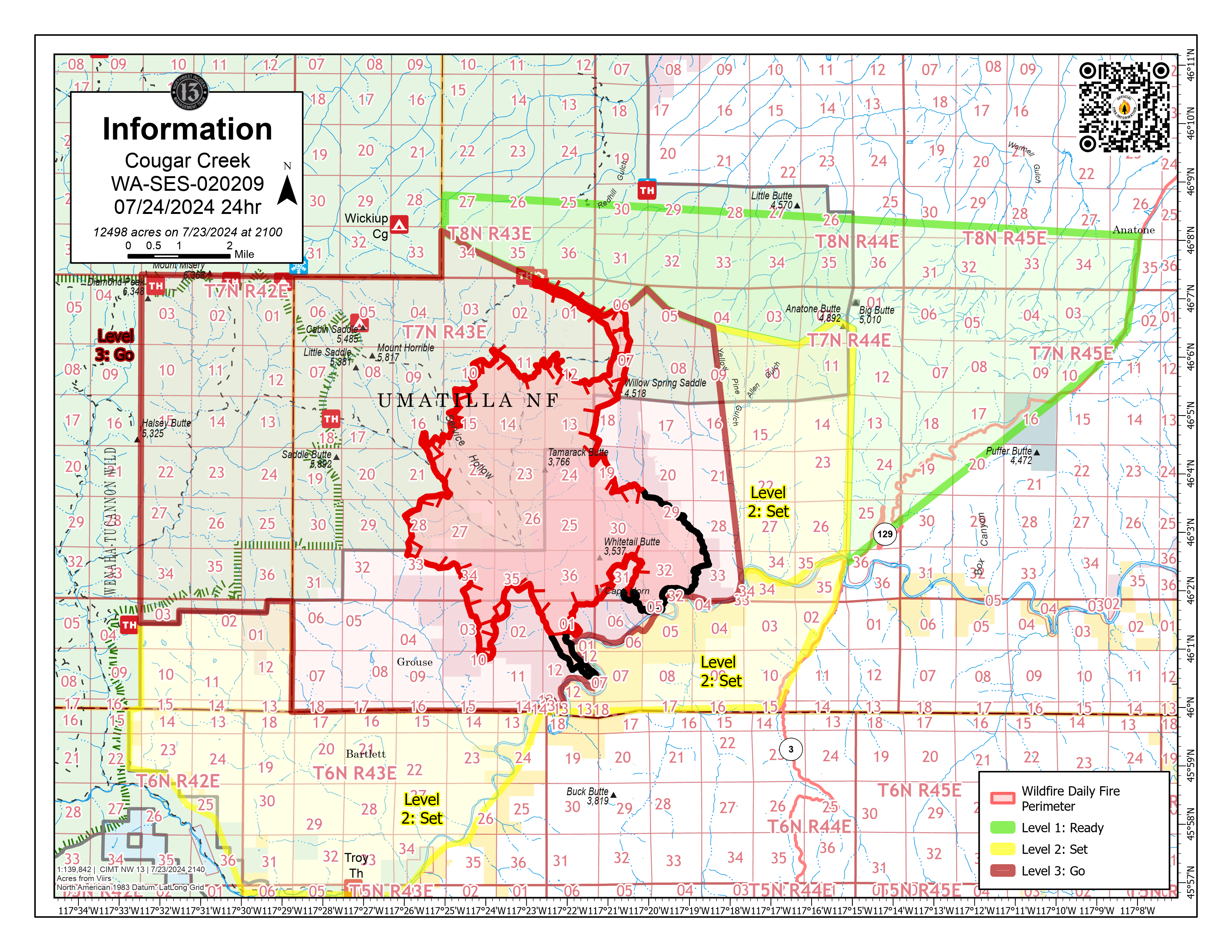
Cougar Creek Fire Update 07 24 2024
Related Incident: Cougar Creek Fire
Publication Type: News
Cougar Creek Fire Update for Wednesday July 24, 2024
KEY MESSAGES:
A significant change in weather arrives today. There is a red flag warning, with strong winds and thunderstorms expected. Wind may become erratic due to a directional wind shift where fire behavior may increase. A Remote Automatic Weather Station (RAWS) was installed near the Wenatchee Guard Station in order to receive site specific weather data. Residents are encouraged to be aware of weather alerts and changing conditions.
A community meeting took place at Bartlett Lane-Union Park in the Grouse Flats area yesterday evening where local residents discussed the current fire environment with incident officials.
CURRENT STATUS:
Crews continue to engage the fire directly and indirectly, day and night. To the southwest, crews are focusing on the Grouse Flats area and have been working south of 4039 road system along the Forest Service and private boundary, adding new dozer and hand lines. Successful tactical ignition operations were accomplished last night near the primitive 050 road near Hansen Ridge in order to limit eastern expansion of the fire perimeter. Moving the incident helibase from Lewiston to Anatone is complete. This move puts air assets closer to the fire and reduces flight time.
FIRE BEHAVIOR AND WEATHER:
A red flag warning is in effect, with possible lightning starting in the afternoon and lasting into the evening. Localized wind gusts may reach speeds of 40 to 50 mph. Temperatures will be in the mid 90s with relative humidity in the mid teens. A cold front will begin to move in during the next few days, dropping the temperature and increasing humidity levels tomorrow.
EVACUATIONS AND CLOSURES:
Forest officials are expanding the temporary closure area related to the Cougar Creek Fire. Closure descriptions and maps are available online on the Umatilla National Forest Closure page. In Washington, evacuation notices are posted on the Asotin County Sheriff webpage and Asotin County Emergency Management Facebook. Grande Ronde Road is closed from Troy, Oregon to Highway 129 junction in Washington. In Oregon, a level 2 evacuation is in effect for Wallowa County, including all of Grouse Flat from Bear Creek Rd north to the State boundary and the Garfield County line to Grande Ronde River.
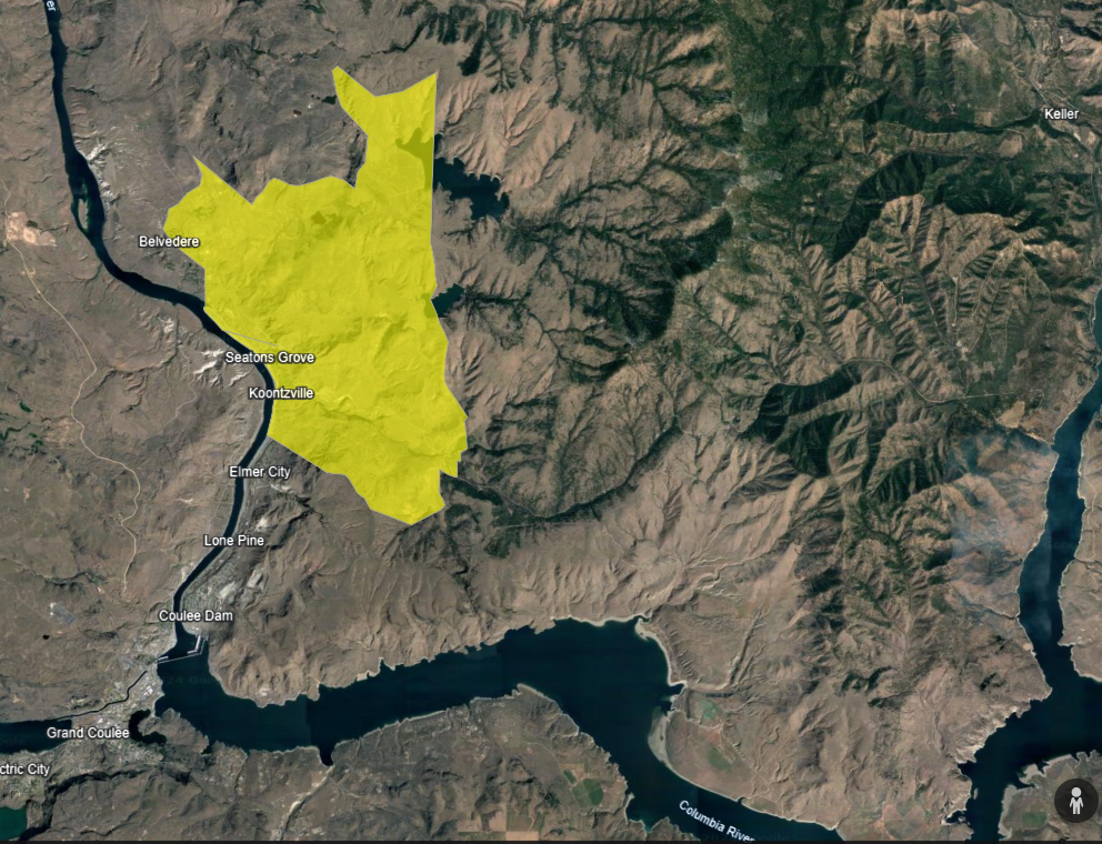
Buffalo Lake and McGinnis Lake area Level 3 Evacuation GO July 24 2024 07 25 2024
Related Incident: Swawilla Fire
Publication Type: News
In addition to the Keller area Level 3 evacuations put into effect on Wednesday July 24 at 7:30 PM, the evacuation ordered by the Colville Tribes Office of Emergency Management, for the area near Buffalo Lake and McGinnis Lake, changed to a Level 3 Evacuation (GO) also Wednesday July 24 at 7:30 PM .
Actualizacin Diaria de Lake Fire 07 24 2024
Related Incident: 2024 Lake Fire
Publication Type: News
Actualización del Incendio Lake 24 de Julio de 2024
Lake Fire Teléfono: 213-631-5455 Horas: 8 a.m. - 8.p.m
Correo electrónico del Incendio Lake: 2024.lake@firenet.gov
Inicio del Incendio Lake: viernes, 5 de julio de 2024 a las 3:48 p.m.
Causa: Bajo investigación
Localización: Cerca del lago Zaca, en el condado de Santa Barbara, al norte de Los Olivos, California.
Tamaño en el momento de la actualización: 38.664 acres
Contención: 90%
Personal: 909
Detalles completos del incidente: https://inciweb.wildfire.gov/incident-information/calpf-2024-lake-fire
Ayer a las 4:00pm la Oficina del Sheriff del Condado de Santa Bárbara canceló todas las Órdenes de Evacuación y Advertencias de Evacuación previamente establecidas debido al Incendio Lake. Se les solicita a los residentes a tener precaución al regresar a sus hogares ya que el personal de emergencia continúa trabajando en el área. La Orden de Cierre del Bosque Nacional Los Padres todavía está en efecto.
La mayor parte del trabajo en el Incendio Lake ha pasado a la reparación de extinción de las actividades contraincendios. Las cuadrillas y los operadores de equipo pesado han estado ocupados rehabilitando las líneas de buldócer, senderos y caminos alrededor del área del incendio. Las cuadrillas están trabajando hacia el sur desde la Escuela Manzana hasta el perímetro del incendio astillando maleza para reforzar las líneas de control. Después de algunas dificultades para llevar el equipo al área, los trabajos de reparación comenzaron desde Miranda Pines Mountain hacia el suroeste. A lo largo del borde sur del incendio, la reparación de extinción está completa en un 95%. Los bomberos están trabajando con asesores de recursos asignados al incidente para identificar sitios culturales sensibles y caminos y senderos dañados.
Ayer, los vuelos de helicópteros y drones con tecnología de cámaras infrarrojas encontraron muy poco calor en las proximidades de la línea de fuego. Los bomberos continuarán buscando incandescencias hasta que estén seguros de que ya no existe una amenaza para la línea de control establecida. Muchos puntos calientes se están quemando por sí solos a medida que los combustibles pesados se reducen a cenizas.
Previsión para el miércoles: Se espera calor persistente y baja humedad hasta el jueves.
Cierre del área del incendio del lago: Algunos caminos y senderos dentro del Bosque Nacional Los Padres están cerrados. Consulte la Orden de Cierre y el Mapa de Orden de Cierre utilizando los enlaces o visitando el sitio web del Bosque Nacional Los Padres. Los cierres permanecerán en vigor hasta el 18 de agosto de 2024, o hasta que sea revisado o rescindido.
Humo: El Distrito de Control de la Contaminación del Aire del Condado de Santa Barbara (APCD por sus siglas en inglés) y el Departamento de Salud Pública del Condado de Santa Barbara han levantado la Alerta de Calidad del Aire en el Valle de Santa Ynez. La vigilancia de la calidad del aire se mantendrá en todo el condado, y las condiciones de calidad del aire se prevé que sea buena a moderada en todo el condado.
Áreas de evacuación: Se han levantado todas las órdenes y advertencias de evacuación del Incendio Lake. El Sheriff del Condado de Santa Bárbara recomienda a todos los residentes del condado a registrarse para recibir alertas de emergencia en ReadySBC.org.
Cierre de carreteras: Visite el Mapa de Cierre de Carreteras del Condado para más detalles.
- Happy Canyon Road en el límite del Servicio Forestal
- Montaña Figueroa justo al norte de la escuela Midland
- Ruta forestal 10N06
- Zaca Lake Road al este de Foxen Canyon Road.
Pyramid Fire Daily Update 07 24 2024
Related Incident: Pyramid and Slate Fires
Publication Type: News
CURRENT SITUATION: In the past few days, significant progress has been made in opening existing roads and establishing a control line around the perimeter of the fire. Additional crews, fire hose, and pumps are being added to strengthen firefighting efforts. Today, heavy equipment and masticators will continue working north and east around the fire's perimeter.
FIRE BEHAVIOR: The fire is burning in an old-growth forest with no recent fire activity. Jeff Shelton, Fire Behavior Specialist, shared that he does not see the potential for significant fire activity to occur within the next three days. Shelton explained that due to light winds, the smoke is not dispersing and is acting like a lid to lessen fire activity.
WEATHER: The weather pattern of weak upper troughing and relatively cool onshore flow will continue for the next several days. Temperatures will remain slightly below normal with elevated humidity and light northwest winds.
CLOSURES: On July 19th, the Willamette National Forest issued an emergency closure order for the Pyramid Fire to ensure public and firefighter safety. Please refer to the link below for a map of the closure area and a list of trails, recreation areas, and forest roads affected by the fire. https://www.fs.usda.gov/Internet/FSE_DOCUMENTS/fseprd1194122.pdf
ROADS: Please be mindful of firefighting equipment when driving in the area. Refer to the emergency closure order for forest roads affected by the Pyramid Fire. For information about all other roads, visit the Oregon Department of Transportation website at https://tripcheck.com
EVACUATIONS: On July 17th, the Linn County Sheriff’s Office, in coordination with the Forest, issued a level 3: Go Now Evacuation Alert for the closure area affected. No residential structures are threatened. The LEVEL 3: GO NOW! Evacuation Alert is primarily impacting forest and recreation areas. Please refer to the Linn County Fire Map https://tinyurl.com/LinnCoFireMap for full details of the issued evacuation area (which will appear in red). Follow the Linn County Sheriff’s Office on Facebook at https://www.facebook.com/LinnSheriff
FIRE RESTRICTIONS: Effective July 17, 2024, fire restrictions apply to all lands within the Willamette National Forest, including the Three Sisters, Mt. Jefferson, Mt. Washington, Waldo Lake, and Diamond Peak Wilderness areas. Read the full restriction at: https://www.fs.usda.gov/alerts/willamette/alerts-notices/?aid=81487