
2024 SQF Lightning Smoke Outlook 07 24 2024
Related Incident: 2024 SQF Lightning
Publication Type: News
Fire
Yesterday’s afternoon thunderstorm activity brought wetting rains to portions of the fire and moderated fire behavior. Today, higher relative humidity and slightly cooler temperatures will continue that moderation; however, additional thunderstorms are possible in the afternoon and outflow winds could cause erratic fire behavior. Expected fire behavior includes smoldering, single tree/small group torching, spotting, and potential short uphill runs. Additional information can be found here SQF Lightning Fires Inciweb
Smoke
Yesterday, smoke transport was impacted by convective thunderstorms and dispersed generally to the N/NW and E. Convective activity will likely impact smoke movement again today, but transport will be generally to the NW through the late afternoon, becoming more SE in the evening. Outflow winds from thunderstorms have the potential to cause erratic smoke movement. Expect generally MODERATE conditions in western foothill communities. The north Owens Valley should see generally GOOD conditions, with MODERATE in the south valley. Smoke will again pool overnight and there is a chance for heavier impact in the Indian Wells Valley overnight.
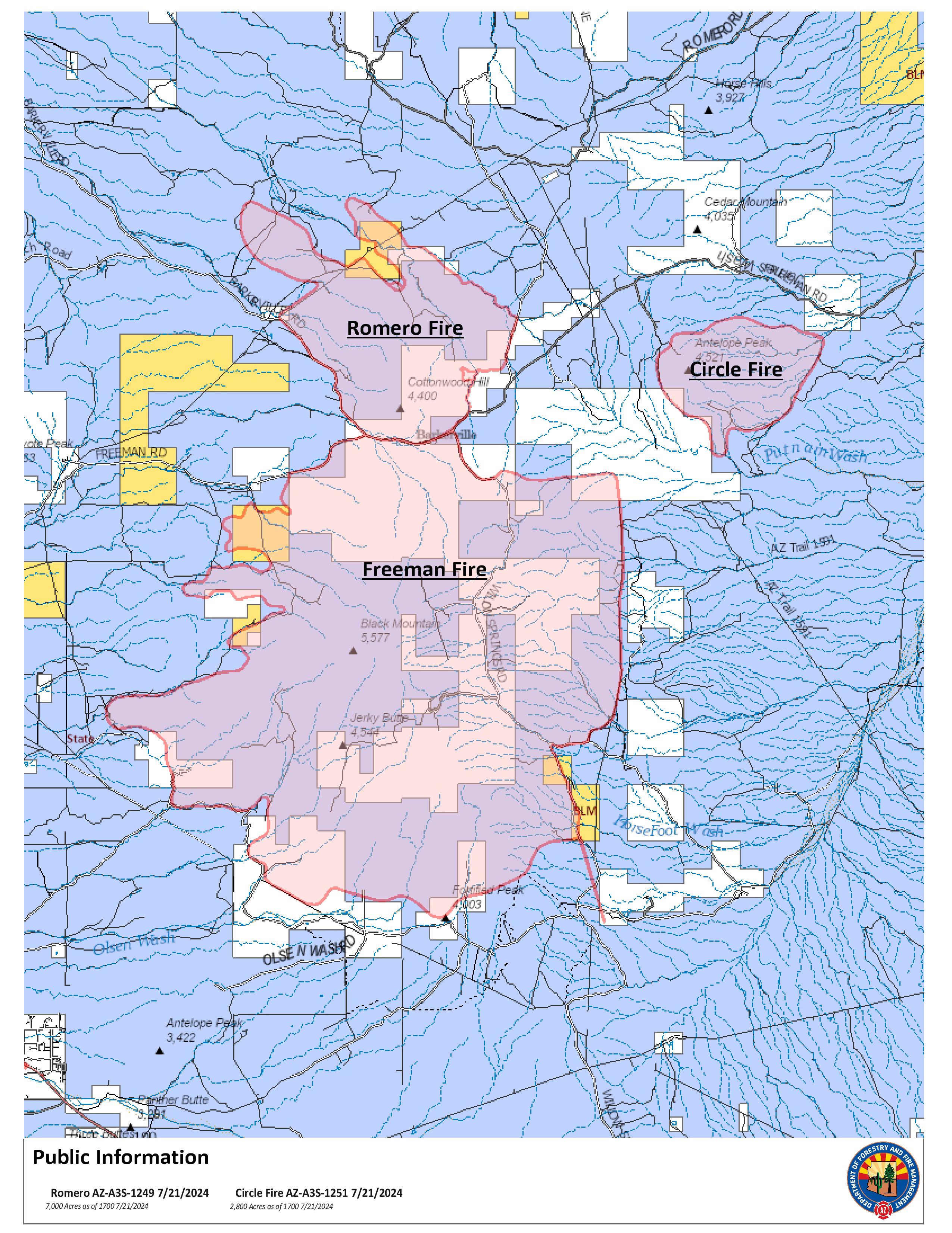
FINAL Romero Update 07 24 2024
Related Incident: Circle
Publication Type: News
Circle Fire Update Wednesday, July 24, 2024
Start Date: Friday, July 19, 2024 Cause: Lightning
Location: 14.5 miles south of Kearny Acres: 2,800
Personnel Assigned: 73 Containment: 85%
Summary: At 7am this morning, the Circle Fire transitioned to a Type 4 Organization. This will be the FINAL Press Release for the Circle Fire. Any future updates will be provided through the incident information sources listed below when significant activity occurs.
“With the Freeman Fire the previous week, we understand the anxiety this incident brought to the nearby communities” stated Incident Commander Eric Huddleston. “We would like to thank the community of Oracle and the owners of Haydon and Cactus Ranches for their support during the Circle Fire. The teamwork between Arizona Department of Forestry and Fire Management, cooperators and federal agencies is what made operations successful in suppressing the Circle Fire quickly”.
Overall, there is minimal fire activity but one crew, two engines, one medical team and one water tender remain assigned to the fire. They will patrol the fire and conduct mop up operations until the fire reaches 100% containment. The Circle Fire is 2,800 acres and 85% contained. The lightning caused fire was discovered on July 19 just after 7pm.
Residents in Pinal County can sign up for emergency alert notifications at: https://www.pinal.gov/1335/PENS---Pinal-Emergency-Notification-Syst to be notified in the event of future emergencies.
Closures: The AZT (Arizona Trail) is closed between Oracle and Kearny. Hikers should plan an alternate route and monitor. All road closures have been lifted. However, firefighters are still working in the area and traveling on Freeman Road, Barkerville Ranch Road, and Willow Springs Ranch Road. We ask that anyone not having a need to be in the area find alternate travel routes. If you must travel the roads listed, please drive at slower speeds and turn on your headlights to be more visible.
Weather: Excessive heat and outflow winds continue over the next few days as forecasted thunderstorms move through the area.
Safety: The TFR has been lifted for the fire. However, we ask that the public avoid flying aircraft (including drones) in and around the fire area. Firefighters remain assigned to the fire and could request air support at any time.
Fire Restrictions: Stage 1 fire restrictions in effect on State Trust lands in Pinal County. Restriction info: http://wildlandfire.az.gov/.
Incident Information: https://inciweb.wildfire.gov/incident-information/aza3s-circle
Twitter: @azstateforestry: https://twitter.com/azstateforestry
Facebook: Arizona Department of Forestry and Fire Management: https://www.facebook.com/arizonaforestry
Ready, Set, Go: https://ein.az.gov/ready-set-go
Speirs Fire Daily Update 07 24 2024
Related Incident: Speirs Fire
Publication Type: News
Current status: The Speirs fire is currently at 715 acres and 48 percent contained.
Recent back burn operations were successful in increasing the
containment of the Speirs fire.
Closures:
• The Firefighter Memorial and Green Dale Group campgrounds are now open.
• The following roads and trails are still closed to public access:
- Forest Service Road (FSR) 610, FSR 689, FSR049 (Green's Draw Road), Lowline trail FST103 its
junction with the Pipe Creek Trail, FST 003. Forest Service Trail 003
from the beginning at the junction with FST 103 to the junction of
Forest Service Trail 004 and Forest Service Trail 004 to Greens Draw
Road 049.
For more information on existing closures, please visit the Ashley
National Forest website: https://www.fs.usda.gov/alerts/ashley/alerts-notices
Looking forward
• Increased fire weather conditions continue to be a factor in the suppression of the Spears fire.
• Monsoonal moisture trends are predicted to enter the fire area on Thursday and continue into the early part of the weekend.
Speirs Fire Information Number: 435-709-8209 (6:00 AM to 10:00 PM.)
Romero Fire Update 07 24 2024
Related Incident: Romero
Publication Type: News
Romero Fire Update Wednesday, July 24, 2024
Start Date: Friday, July 19, 2024 Cause: Lightning
Location: 13 miles southwest of Kearny Acres: 7,392
Personnel Assigned: 127 Containment: 70%
Summary: At 6am this morning, the Romero Fire transitioned to a Type 4 Organization. This will be the FINAL Press Release for the Romero Fire. Any future updates will be provided through the incident information sources listed below when significant activity occurs.
The Romero Fire is 7,392 acres with an increase to 70% containment. The increase in acreage is due to firing operations conducted on the northeast corner of the fire these past 2 days. This operation was done to secure the northeast corner that has been moving around over the past few days. Firefighters did mop up around the fire perimeter and cleaned up dozer line to strengthen and improve the fire line.
Two crews, two engines, one medical team, and one water tender remain assigned to the fire. They will patrol the fire and conduct mop up operations until the fire reaches 100% containment.
Residents in Pinal County can sign up for emergency alert notifications at: https://www.pinal.gov/1335/PENS---Pinal-Emergency-Notification-Syst to be notified in the event of future emergencies.
Closures: The AZT (Arizona Trail) is closed between Oracle and Kearny. Hikers should plan an alternate route and monitor. All road closures have been lifted. However, firefighters are still working in the area and traveling on Freeman Road, Barkerville Ranch Road, and Willow Springs Ranch Road. We ask that anyone not having a need to be in the area find alternate travel routes. If you must travel the roads listed, please drive at slower speeds and turn on your headlights to be more visible.
Weather: Excessive heat and outflow winds continue over the next few days as forecasted thunderstorms move through the area.
Safety: The TFR has been lifted for the fire. However, we ask that the public avoid flying aircraft (including drones) in and around the fire area. Firefighters remain assigned to the fire and could request air support at any time.
Fire Restrictions: Stage 1 fire restrictions in effect on State Trust lands in Pinal County. Restriction info: http://wildlandfire.az.gov/.
Incident Information: https://inciweb.wildfire.gov/incident-information/aza3s-romero
Twitter: @azstateforestry: https://twitter.com/azstateforestry
Facebook: Arizona Department of Forestry and Fire Management: https://www.facebook.com/arizonaforestry
Ready, Set, Go: https://ein.az.gov/ready-set-go
Red Fire Closure Order 07 22 2024
Related Incident: Red Fire
Publication Type: Closures
ORDER NO. 06-01-02-24-02
FIRE AREA EMERGENCY CLOSURE DESCHUTES NATIONAL FOREST CRESCENT RANGER DISTRICT
Pursuant to 16 U.S.C. 551, 36 C.F.R. § 261.50(a) and (b), the following acts are prohibited on National Forest System lands, roads and trails within the following described area on the Deschutes National Forest, Crescent Ranger District, as described in the attached Exhibit A. This Order becomes effective on July 24, 2024, and will remain in effect through October 1, 2024, until rescinded sooner.
PROHIBITIONS:
1. Going onto or being within an area closed for public health and safety. 36 CFR § 261.53(e).
2. Being on a trail within the Closure Area. 36 CFR 261.SS(a).
3. Being on the road within the Closure Area. 36 CFR 261.54(e).
The area described below will be closed to public access/entry due to hazards and hazardous conditions created because of the Red Fire burning northwest of Crescent, Oregon.
CLOSURE AREA:
The closure area is located within the State of Oregon, Klamath County, and within the Administrative Boundaries of the Deschutes National Forest. The closure applies to the NFS areas and trails described below. The closure area is depicted on the attached map, which is incorporated into this order as "Exhibit A". All areas, trails, campgrounds, and rec sites in this closure area are closed.
AFFECTED AREA/CLOSURE AREA:
The closure boundary begins south of Odell Lake Resort on the southeast end of Odell Lake, extending from the Diamond Peak Wilderness boundary to Highway 58, extending south to Crescent Junction Sno-Park west of the intersection of Highway 58 and County RD 60. The closure boundary follows the
north side of County RD 60, skirting private land and continuing southwest along to the National Forest RD 60 and NF RD 6005. From there the closure area boundary continues along the southeast boundary of the Diamond Peak Wilderness and extends across Crescent Lake to NF RD 6015 on the east side of the lake, south along the 6015 to the 6015/6020 junction, then west along the NF RD 60 to the junction of NF RD 60 and NF 6010 Road (Summit Lake RD). The closure includes a portion of the NF RD 60 south of the 60/6020 junction to the 6020/6030 junction. The closure extends along NF RD 6010 to Summit Lake and includes the border of Summit Lake.
Trails and Trailheads:
- Crater Butte Trailhead
- Metolius Windigo Trail
- Fawn Lake Trail Head
- Windy/Oldenburg Trailhead
- Meek Lake Trailhead
- Snell Lake Trailhead
Campgrounds, Rec Sites and Resorts
- Simax Group Campground
- Crescent Lake Campground
- Summit Lake Campground
- Spring Campground
- Contorta Point Campground
- Windy Group Campground
- Whitefish Creek Horse Camp
- Crescent Junction Sno-Park
- Crescent Lake Sno-Park
- Crescent Lake Resort
- Old Simax Day Use site
- Simax Beach North Day Use
- Simax Beach South Day Use
- Crescent Lake Day Use Area
- Tranquil Cove Day Use
- Tandy Bay Day Use Site
Roads:
- NF-018
- NF-050
- NF-620
- NF-625
- NF-290
- NF-200
NF-6005 RD - NF 6010 RD
Other:
- Crescent Lake State Airport
- Crescent Recreation Residences 1-73
- Crescent Lake Guard Station (FS rental)
- Makualla Boy Scout Camp
EXEMPTIONS:
Pursuant to 36 CFR § 261.S0(e), the following are exempt from this Order:
(1) Any Federal, State, or Local Officer, or member of an organized rescue or fire fighting force in the performance of an official duty.
(2) Owners or lessees of land in the affected area.
This prohibition is in addition to the general prohibitions in 36 CFR Part 261, Subpart A.
Violations of this prohibition are punishable by a fine of not more than $5,000 for an individual or
$10,000 for an organization, or imprisonment for not more than 6 months, or both (16 USC§ 551; 18 USC§ 3551, 3559, 3571, and 3581).
Completed in Crescent, Oregon on July 24, 2024.
Forest Supervisor
Smoke Outlook Eastern Oregon July 24 2024 07 23 2024
Related Incident: Lone Rock Fire
Publication Type: News
Smoke Outlook 7/24 - 7/25 Eastern Oregon
Special Statement
An Air Quality Alert has been issued by the Oregon Department of Environmental Quality for Harney, Malheur, Grant, Baker, and Morrow Counties until further notice.
Fire
There are multiple fires affecting the forecast area. For more information on these incidents, please visit Inciweb.
Smoke
A cold front will pass through this afternoon, resulting in northwest winds. This shift will lead to greater impacts in areas southeast of active fires. Thunderstorms and gusty winds are possible and can increase smoke in some areas and decrease it in others. In general, given the proximity to active fires, Spray and Monument are expected to have HAZARDOUS conditions. Burns, John Day, and Seneca are expected to have UNHEALTHY air quality. In these areas, air quality will improve during the day and worsen overnight as smoke settles in. The air quality in Ontario and Drewsey is expected to be UNHEALTHY FOR SENSITIVE GROUPS.
Silver King Fire Daily Update July 24 2024 07 24 2024
Related Incident: Silver King Fire
Publication Type: News
Public Information Phone: (435) 310-5450 Email: 2024.silverking@firenet.gov
Agency: Fishlake National Forest – Beaver Ranger District
Location: Approximately three miles west of Marysvale, Utah
Start Date: July 05, 2024
Cause: Lightning
Acres: 18,189
Containment/Completion: 83%
Personnel: 239
Happy Pioneer Day! Silver King Fire personnel wish all Utahns a safe and enjoyable holiday!
Many areas around the Silver King Fire are popular for off-highway vehicle recreation. For those planning to spend the holiday riding the trails, we encourage you to observe Tread Lightly!’s T.R.E.A.D. Principles.
Travel Responsibly – stay in designated areas and on designated trails, roads, and waterways
Respect the Rights of Others – including private property owners and other recreationists
Educate Yourself – obtain travel maps and know the regulations for public agencies
Avoid Sensitive Areas – especially wet soils, wildlife habitat, and historical resources
Do Your Part – model appropriate behavior, properly dispose of waste, and leave the area better than you found it
These principles are especially important in the fire area. Please exercise extra caution, watching for fire equipment and personnel. Remember to abide by the Stage 1 Fire Restrictions and avoid activities that could potentially cause another fire. Know and observe the Forest Closure Order still in effect. Details of the closure can be found at: https://www.fs.usda.gov/alerts/fishlake/alerts-notices.
Suppression and repair remain the focus for firefighters. On the north side of the fire, crews continue to patrol and monitor the perimeter. On the east side, personnel continue dozer line rehabilitation and reseeding. On the south and west sides, firefighters monitor and secure edges where possible.
Moisture will return to the area today, resulting in afternoon showers and thunderstorms. Wetting rains will be possible with these storms, along with gusty outflow winds and lightning. Humidity will be in the mid-20 to mid-30 percent range and temperatures will warm into the upper-70s to mid-80s. Smoke impact will remain minimal.
Lone Rock Fire Update July 24 2024 07 24 2024
Related Incident: Lone Rock Fire
Publication Type: News
LONE ROCK FIRE UPDATE July 24, 2024
Location: Lonerock, Oregon to west of Highway 207 | Size: 134,752 acres | Containment: 40% Cause: Under Investigation | Start Date: July 13, 2024 | Total Personnel: 1,031
InciWeb: https://inciweb.wildfire.gov/incident-information/orprd-lone-rock-fire
Fire Information Line: 541-208-4369
Email: 2024.0404rvlonerock@firenet.gov
Condon, Ore. — The Lone Rock Fire is being managed under a full suppression strategy by the unified command of the Northwest (NW) Team 2 and Oregon State Fire Marshal (OSFM) Red Team.
Crews and OSFM structural task forces carried out firing operations and structure protection on the southern portion of the fire. These operations were successful, and firefighters were able to hold the line with minimal spotting. Where fire did extend beyond the planned control lines, firefighters were quick to secure and contain any minimal spot fires.
On the northern portion of the fire, crews continued to patrol the fireline with no change in fire activity in the area with 40 percent containment.
Strategic aerial firefighting plays a critical role in firefighting efforts when supported by firefighters on the ground. Aerial supervision provides birds-eye identification of hot spots and coordinates where to send helicopters equipped for suppression and is needed when there are multiple aviation assets in the air. Use of aircraft for strategic aerial firefighting is constantly evolving based on resource availability, weather, and smoke conditions. Strategic aviation resources were also used for aerial ignition with a plastic sphere dispenser (PSD) on Tuesday. The PSD allowed firefighters ease in connecting large areas of unburned fuels that threated to extend beyond the western edge of the fire along FSR 25. Task forces conducted structure assessment of areas to the west of FSR 25 and crews identified a small spot to the west of Notch Road. Crews worked through the evening to build line around this spot to reduce further growth.
OSFM structural task forces worked with their wildland partners to hold Highway 19 and support firing operations. Crews were also able to access areas of the fire that previously burned to begin damage assessments. During their initial assessments, OSFM resources identified three primary residences that were destroyed by the fire. Assessments will continue as firefighters are able to get into more areas, some additional structure damage may be found. An additional structural task force from Marion County arrived, bringing the total number of OSFM structural task forces to 13.
Yesterday’s Activities: Firefighters worked through the day along the eastern side of the fire perimeter to build control lines from Burton Hill to the south. The steep terrain between Forest Service Road (FSR) 21 and FSR 25 continued to pose challenges for control. Crews used existing dozer line and water tenders to suppress fire activity in this area. Night crews continued these suppression tactics by beginning to construct a hose lay along the fireline. Additionally, indirect dozer line is being used as a contingency. South of FSR 25 crews continued to secure the fireline with direct and indirect line and begin mop-up activities where fire behavior allowed.
Today’s Activities:
Patrols and mop-up activities to maintain the existing fire perimeter will continue today in anticipation of some
incoming weather. There is a Red Flag Warning in effect from 12:00 p.m. through 11:00 p.m. this evening for abundant lightning for local fire weather zones. Thunderstorms in the afternoon and evening hours to the southeast of the fire perimeter may bring strong winds, lightning, and overall instability to the fire area. Shifting winds patterns, particularly in the tight canyons and draws, may test containment lines.
The focus for much of the uncontained fire perimeter will be on holding the existing line, connecting control line, and prepping unburned areas. Sprinkler line will continue to be installed on the fire’s western perimeter between FSR 21 and FSR 25 for holding where terrain allows. Similarly, crews along the south and southwest of the fire perimeter will
focus efforts on mop-up and holding. Crews along Alder Creek and near the western side of FSR 25 will continue to hold heat built during firing operations to control fire activity along highway 19 to the south and FSR 25 along the western fire perimeter. Crews will continue to build containment line and secure the spot near Notch Road using direct dozer line. OSFM task forces will be focused on prepping and mopping up around structures along Winlock Road. Structural task forces will also work to access more homes within the fire perimeter to complete damage assessments.
Evacuations:
• Level-3 Evacuations – GO NOW! Level-3 Evacuate immediately for the following areas:
o Gilliam County: residences South of Lonerock. For more information on evacuations, visit Gilliam County Sheriff's Office Facebook page.
o Wheeler County: highway 19 at Rowe Creek Road, south on Rowe Creek Road to Twickenham Bridge, to highway 19 at Girds Creek, east to the county line, north of the county line to Morrow County line, west on the northern county line, south through the Kinzua area, south back to Rowe Creek Road. For more information on evacuations, visit Wheeler County Sheriff’s Office Facebook page.
o Morrow County: from the west County Line along Buttermilk Canyon to highway 207, Mile Post 10 south of Hardman to the south Morrow County line. East of Highway 207 and south of FSR 21 to the eastern county line. For more information on evacuations, visit Morrow County Sheriff's Office Facebook page.
• Level-2 Emergency Alert – GET SET! Level-2 Be set to evacuate at a moment’s notice for the following areas:
o Gilliam County: residences north of Lonerock. For more information on evacuations, visit Gilliam County Sheriff's Office Facebook page.
o Wheeler County: HIGHWAY19/Rowe Creek to Twickenham then Girds Creek/HIGHWAY 207 S, south on HIGHWAY 207 to Cherry Lane west to the Grant County line. For more information on evacuations, visit Wheeler County Sheriff’s Office Facebook page
Shelters:
• An evacuation center has been set up at the Wheeler High School (600 E B Street, Fossil, Ore.). A large animal shelter is available at the County Fairgrounds (720 E 3rd Street in Fossil, Ore.).
Closures:
• OR-19 is closed all hours of the day between milepost 78.7 to milepost 95.2. OR-207 is closed between the hours of 8:00 a.m. and 8:00 p.m. to provide for firefighter and traveler safety with active equipment and fire activity to the west of the highway. For updated road closure information, visit https://www.tripcheck.com/.
- Umatilla National Forest Order Number 06-14-02-24-01 affects all National Forest System lands, trails, and roads that lay within the Proclamation Boundaries of the Umatilla National Forest and reside within Wheeler County.
- Umatilla National Forest Order Number 06-14-02-24-02 includes prohibitions within the Heppner Ranger District on the Umatilla National Forest.
- Bureau of Land Management Prineville District Office issued an Emergency Public Land Closure on BLM- managed lands along the main stem John Day River from Kimberly, Ore. To Dale, Ore.; and along the North Fork John Day River from Kimberly, Ore. to Dale, Ore.
Weather: The National Weather Service in Pendleton has issued a Red Flag Warning for abundant lightning, which is in effect from 12:00 p.m today through 11:00 p.m. Passing thunderstorms will bring strong, erratic winds, small hail, and abundant lightning. There is no longer a Fire Weather Watch; however, fire activity could be accelerated with the incoming winds. Winds are anticipated from the south and southeast with maximum ridgetop gusts of 45 to 60 mph this evening.
- Umatilla National Forest Order Number 06-14-02-24-01 affects all National Forest System lands, trails, and roads that lay within the Proclamation Boundaries of the Umatilla National Forest and reside within Wheeler County.
- Umatilla National Forest Order Number 06-14-02-24-02 includes prohibitions within the Heppner Ranger District on the Umatilla National Forest.
- Bureau of Land Management Prineville District Office issued an Emergency Public Land Closure on BLM- managed lands along the main stem John Day River from Kimberly, Ore. To Dale, Ore.; and along the North Fork John Day River from Kimberly, Ore. to Dale, Ore.
Smoke Information: Visit https://fire.airnow.gov/ for local air quality information.
Flight Restrictions: A Temporary Flight Restriction (TFR) is in place above the Lone Rock Fire area. If you fly, we can’t. Unauthorized drone flights (UAS) pose serious risks to firefighter and public safety and the effectiveness of wildfire suppression operations. Aerial firefighting is suspended when unauthorized UAS are in the area, allowing wildfires to grow larger.
###
Battle Mountain Complex 07 24 2024
Related Incident: Battle Mountain Complex
Publication Type: News
Progress continues as challenging conditions persist
UKIAH, Ore. – Firefighters on the Monkey Creek Fire continued to see challenging weather and very active fire behavior, but they held established lines tightly without much growth on key priorities.
Limited visibility over the fire kept helicopters grounded early in the day, so air resources were shared with the Double Snag Fire to the east until the smoke lifted in the afternoon. When they returned, they were able to help slow fire growth on the northern portion of the fire. Crews in the north continued to tie in dozer and contingency lines.
Although fire behavior was highly active on the eastern portion of the fire, crews were able to keep the fire from moving south and northeast and kept the fire from crossing Highway 395 and Camas Creek to the east. They also prepared for nighttime firing operations to remove fuels from existing indirect lines.
Crews continue to hold the southeastern flank of the head of the fire. In that very active portion, they are also burning out the remaining vegetation between the fire and indirect lines.
Because of where the fire has shifted and expanded, crews working farthest from fire camp in Ukiah, will move to and be supported by the Boneyard fire camp. This will help reduce two hours of driving each day, which gives them more time to rest and mitigates risks associated with driving.
Crews will continue mop-up operations and patrolling on the 4,485-acre North Fork Owens Fire, which stands at 40% containment (the complex stands at 5% containment). Pockets of unburnt vegetation remain within the fire’s footprint. Residents should expect to see some smoke in the interior. Division resources will patrol the perimeter overnight and support local initial attack for any new starts.
Evacuations: Level 1 (Be Ready), Level 2 (Be Set) and Level 3 (Go Now) evacuations are in effect. For updated information, visit:
- For Umatilla County, follow facebook.com/UmatillaCountySheriff or sign up for Umatilla County Emergency Alert System at https://member.everbridge.net/index/2590041373147145.
- For Grant County, visit the RAPTOR arcgis site or sign up for alerts at: https://member.everbridge.net/index/825462649520134.
FIRE AT A GLANCE
Total Estimated Size: 52,832 acres
Monkey Creek: 48,348
North Fork Owens: 4,485 acres
Snake: (Merged with Monkey Creek)
Containment: 5%
Cause: Under Investigation
Estimated Cost: $3,500,000
All Resources
Hand Crews: 18
Engines: 34
Water Tenders: 16
Dozers: 10
Helicopters: 6
Total Personnel: 678
Swawilla and Bridge Creek Fires Community Meeting 07 24 2024
Related Incident: Swawilla Fire Bridge Creek
Publication Type: Announcement
.png)

Swawilla and Bridge Creek Fires Community Meeting Wednesday July 24, 2024 7pm at the Keller Community Center Please join Northern Rockies Complex Incident Management Team 6 to learn more and ask questions.