Highlighted Activity
A TFR (Temporary Flight Restriction) is in place. Wildfires are a no drone zone! Remember, If you fly, we can’t! Any interference with aerial suppression efforts will result in grounding aircraft until the area is clear.
Update 7/21 @ 10am: A press release is available under the NEWS tab above
Update 7/20 @ 5:30pm: Acreage at 4,200 and growing as firing operations continue. Crews are working quickly ahead of a storm cell moving into the area with forecasted wind gusts up to 50mph. A LAT and 2 SEATs have made multiple retardant drops to stop the advancing fire’s edge through coordination with Aravaipa IHC guidance on the ground. 3C Ranch located to the west of the fire, near Barkersville Rd is in SET.
Update 7/20 @ 0900: Air Attack has been ordered to recon the fire. Resources continue to arrive onscene and engage in fire suppression efforts.
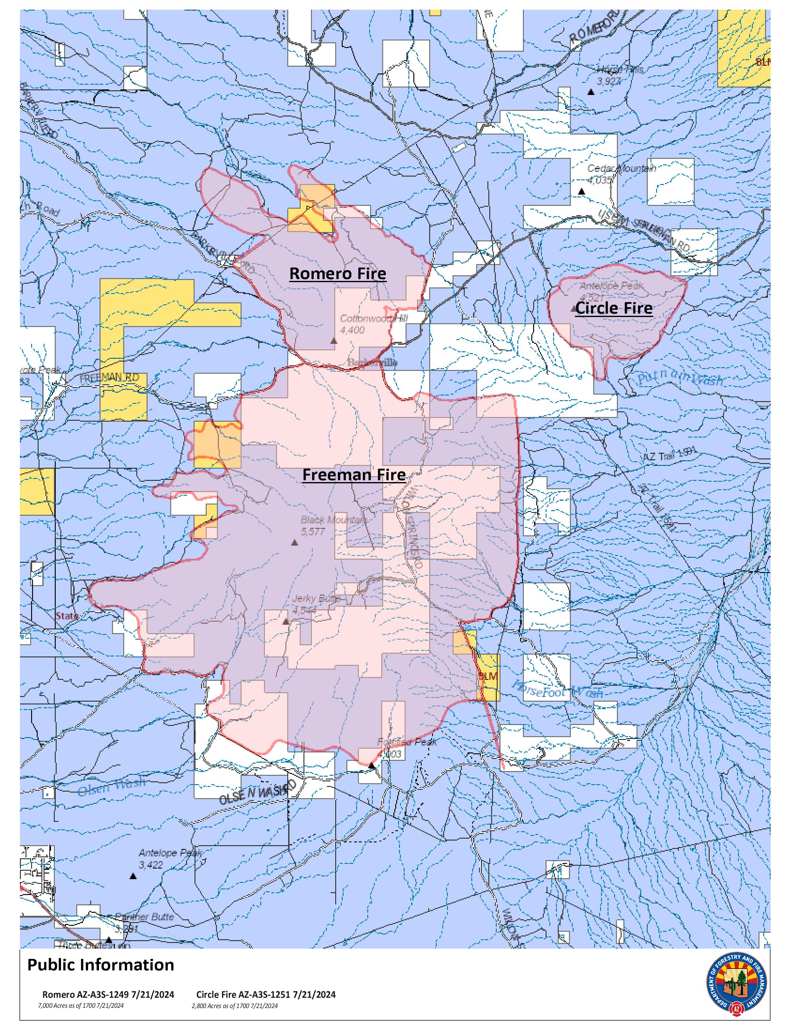
The Romero Fire was discovered on July 19 at 6:36 pm. The fire is burning in grass and brush, north of the Freeman Fire burn scar. Fire behavior includes active flame with smoldering, creeping and running.
As of 7/9 at 11:30pm, there are no road closures. The public is asked to avoid the area to allow firefighters to conduct full suppression efforts without risk to public safety. For the most up to date road conditions, visit AZ 511.
The cause of the fire is unknown at this time. The priority of resources working the Romero Fire is to implement full suppression tactics to prevent further spread while first providing for firefighter and public safety. When it is safe to do so, an investigation will be conducted to determine the cause of the fire. Once the determination has been made, the information will be released to the public.
Closures: Freeman Road is closed. Deputies will be placed at roadblocks throughout the fire area. The public is asked to avoid the fire area, including Barkersville and Willow Springs Road. The AZT (Arizona Trail) is closed between Oracle and Kearny. Hikers should plan an alternate route.
Current as of | Sun, 07/21/2024 - 21:49 |
---|---|
Incident Time Zone | America/Phoenix |
Incident Type | Wildfire |
Date of Origin | |
Location | 13 miles SW of Kearny, approx 14 miles West of Dudleyville |
Incident Commander | Mark South - IC Type 3, Jeff Gallivan - IC Type 3 Trainee |
Coordinates |
32° 52' 16'' Latitude
-110° 58' 23
'' Longitude
|
Size | 7,000 Acres |
---|---|
Percent of Perimeter Contained | 30% |