
Battle Mountain Complex 07 25 2024
Related Incident: Battle Mountain Complex
Publication Type: News
Thunderstorms and wind gusts increase fire behavior
UKIAH, Ore. – Firefighters faced another day of challenging weather with high temperatures and gusty, changing winds from thunderstorms in the area. The wind-driven increase in fire behavior created spot fires as far as a half mile away – one of which was roughly 200 acres.
“The vegetation is so receptive that just one ember can take off,” said Field Operations Section Chief Eric Perkins. “We’re seeing late-summer, mid-August conditions out here.”
Along the northern section, crews quickly suppressed and lined spot fires and will continue to prepare the line for burning operations.
Along Highway 395, crews performed firing operations to remove unburnt vegetation, so it doesn’t reignite and spot across the highway. The Oregon Department of Transportation removed hazardous, standing dead trees. Tree removal will continue over the coming days with heavy equipment using the roadway.
Crews also faced active fire behavior along the south end of the fire where fire crossed the lines as firefighters attempted to connect roughly seven miles of dozer line. Crews were able to hold the southeast corner of the fire with the help of helicopter bucket drops late in the afternoon.
ODF’s Team 1 and Team 3 are coordinating with each other to align objectives to manage operations as the Monkey Creek and Boneyard fires are expected to merge in the coming days.
Crews will continue mop-up operations and patrolling on the 4,485-acre North Fork Owens Fire, which stands at 40% containment (the complex stands at 5% containment). Crews saw some spot fires today with wind gusts, but firefighters quickly quelled the new starts.
Evacuations: Level 1 (Be Ready), Level 2 (Be Set) and Level 3 (Go Now) evacuations are in effect. For updated information, visit:
- For Umatilla County, follow facebook.com/UmatillaCountySheriff or sign up for Umatilla County Emergency Alert System at https://member.everbridge.net/index/2590041373147145.
- For Grant County, visit the RAPTOR arcgis site or sign up for alerts at: https://member.everbridge.net/index/825462649520134.
- For Morrow County, visit https://experience.arcgis.com/experience/de78333b0d2544f7a320142174aa20ae
Gold Complex evening update July 24 2024 07 25 2024
Related Incident: Gold Complex
Publication Type: News
Quick Facts
- Acres: Mill, 2,951; Smith, 56
- Containment: Mill 0%; Smith 0%
- Detection Date: July 22, 2024
- Cause: Lightning
- Crews: 15
- Engines: 127
Dozers: 16
Helicopters: 9 + 3 night-flying - Fixed wing: available as needed
Total resources: 910
Real-time map-based information (no log in needed) is available at: egp.wildfire.gov/egp/Default.aspx and click on the "Wildfire Map" button in the righthand column.
Evacuation information: facebook.com/plumascountysheriff or facebook.com/sierracosheriff
Headlines
• Join us for an Ask-the-Incident Commander meeting starting tomorrow (technology permitting), July 25, 2024, at 2 p.m. daily. https://www.facebook.com/USFSPlumas
• California Complex Interagency Incident Management Team 10 (CCIIMT) took command of the Gold Complex (Smith and Mill Fires) at 0600 on July 24, 2024.
• An infrared-capable Uncrewed Aircraft System (UAS) arrived at the fire today to assist with mapping capabilities.
Operational update
Smith Fire: Line around the Smith Fire held today. Crews are keeping a close eye on hot spots near the line that could threaten containment and continued to mop up to the extent possible.
Mill Fire: Crews again made excellent progress today and the Mill Fire has been almost completely lined. However, there are still numerous hot spots, burning snags, and other hazards near the fire lines that could threaten containment and spot fires are possible. Crews continued to work on mitigating those hazards today, but there is still considerable work to be done. In addition, wind speeds are expected to increase tomorrow, with the possibility of gusts up to 30 m.p.h. These winds could threaten containment, so work continues to strengthen lines and to build contingency lines in case of an increase in fire behavior tomorrow.
Crews are on 24-hour shifts around structures and critical powerlines. Engines remain pre-positioned in neighborhoods and dozers will continue to build and reinforce lines overnight. In addition, crews are still utilizing helicopters with night-flying water-dropping capabilities to aid firefighting efforts on the ground.
Weather
While temperatures are expected to cool over the next few days, both increased winds and lower relative humidities are expected to persist into the weekend.
#####
Clearwater Fire Report for Wednesday 07 31 2024
Related Incident:
Publication Type: News
Summary: The Clearwater Fire started on Friday, July 19th, 2024, in the early afternoon. The fire is located in the Elk Fork vicinity. The location of the fire is very difficult terrain that makes suppression efforts challenging. The fire cause was from lightning.
The aerial assessment of the Clearwater Fire showed growth along the Elk Fork Canyon and Highway 14 Corridor; fortunately, the fire did not cross the highway nor travel south along the Elk Fork Drainage. A Type 1 helicopter will be used to support containment in Elk Fork. Crews will finish structure protection preparation work in the Bill Cody Ranch area and begin fuel reduction work in the Moss Creek and Aspen Creek areas.
Closures: Elk Fork Campground, Wapiti Campground, Big Game Campground, Wapiti Ranger Station, and Pagoda Summer Homes are all closed. These closures provide public safety and increased access to fire resources. A road and trail closure are in effect at NFS Road #424, Elk Fork Road and NFS Trail # 760, Elk Fork Trail. The purpose of this Order is to protect human health and safety from the Clearwater fire. More information can be found: https://www.fs.usda.gov/detailfull/shoshone/alerts-notices/?cid=stelprdb5175892
Weather | Anticipated Fire Behavior: The fire is burning through timber, brush and thick, dead and down fuels on steep slopes. A milder day is in store for the fire today, with higher relative humidity, lower temperatures, and average winds being forecasted. Warmer temperatures throughout the remainder of the week could create challenges for potential fire growth.
Important Information: Risk to responders and public safety remain the highest priority for the incident management team. The Clearwater fire has not been the only fire contributing to the smoke in the air. Smoke from fires in Canada as well as Idaho and the Northwest
To receive email updates please contact the email address above.
Level 2 Evacuation Notice for Stehekin begins 8 am July 25 07 24 2024
Related Incident:
Publication Type: Announcement
Evacuation Levels, going down lake: Beginning at 8 a.m. on Thursday, July 25
- Level 2: Extends through the Stehekin Valley, including the Stehekin Landing to High Bridge. Visitors must leave now.
- Level 3: From Hazard Creek to Safety Harbor (Get out now!)
- Level 2: From Safety Harbor to Camas Creek
- Level 1: From Camas Creek to Mitchell Creek
- Evacuation routes and established areas of refuge
Go to the Chelan County Emergency Incidents Map to view evacuation levels.
Level 1 means there is a fire advisory, be alert and monitor resources.
Level 2 means be prepared to leave the area in an emergency.
Level 3 means get out now!
Boat schedule for July 25 evacuations:
The boat company will have transportation leaving Stehekin from the landing at its normal scheduled times on July 25:
Express - 12:30 p.m. departure
Liberty - 3:30 p.m. departure
The following is additional information from the Lake Chelan Boat Company:
Day Trips
Due to fire conditions in Stehekin we are not going to be running day trips into Stehekin on July 25. We will take care of rebooking your tickets to another day or we will get you canceled as soon as we can. Just send us a note to info@ladyofthelake.com and let us know what you would prefer.
Overnight
Due to fire conditions in Stehekin, we will not be taking folks into Stehekin on July 25 unless you have property in the area. Please check in with us and we will be happy to get you back into Stehekin at a later date. We will be running the Lady Express and the Lady Liberty as schedule to assist in getting passengers out of Stehekin. If you were already booked on a boat for a future date, your ticket will be honored on that same boat. If you are not on a boat scheduled out, please stop by the Bike Stand or call our office or head to the boat and we will try to get on.
A Level 2 evacuation means no tourism-related visitors will be ferried into Stehekin.
We are requiring the following groups to leave Stehekin on July 25:
• All tourism-related visitors
• All campers and hikers
Emergency Management and the Chelan County Sheriff’s office will be staged in Stehekin. Because of firefighting efforts, it is vital the above groups leave Stehekin under the Level 2 order.
Please check back on this page and our website (link below) for the boat schedule, which we will post as soon as we have it. We will also post the times to be at the landing for transportation out of Stehekin Thursday.
Parking is extremely limited at the landing; the space is needed for fire equipment and emergency personnel. Please use the recommended parking area at the airfield. Shuttle buses running along Stehekin Valley Road will provide transport to the landing.
Areas of Refuge, with shuttle service, have also been established at the Stehekin Ranch, airfield, Buckner Orchard and Stehekin bakery. See the attached evacuation routes and locations.
For residents and property owners, we strongly advise you begin to prepare to leave at a moment’s notice. Have your valuables packed and an exit strategy to the airfield.
In the event of a Level 3 evacuation, we typically go door-to-door, advising people to leave. However, in an emerging situation, we cannot guarantee that we will be able to reach you.
Residents can find fire information on the fire information board at the Stehekin landing. A public Information Officer (PIO) is stationed in Stehekin and is available to answer questions. PIOs visit local businesses daily to provide current updates. A PIO can provide visitors with information to assist with their plans to leave the area.
Monitor the Chelan County Emergency Incidents Map for evacuation levels:
https://chelangis.maps.arcgis.com/.../media/index.html...
EM Active Emergencies webpage: https://www.co.chelan.wa.us/emer.../pages/active-emergencies
Settings - change map background and toggle additional layers
Filter - control incident types displayed on map.
Zoom to your location
Reset map zoom and position
Could not determine your location.
Show Legend
 Wildfire
 Prescribed Fire
 Burned Area
Response
Burned Area
Response Other
Other
Apache Fire
Unit Information
Incident Contacts
Pincer Two fire Update 07 24 2024
Related Incident: Pincer Two Fire
Publication Type: News
Pincer Two Fire
Incident Commander: Gene Phillips
Fire Information Phone: 360-859-9262
Email: 2024.minerscomplex@firenet.gov
Facebook: www.facebook.com/MTBakerSnoqualmieNF
InciWeb: Pincer Two Fire
X: twitter.com/MtBakerSnoNF
5:30 PM, July 24, 2024
Estimated size: 80 acres
Start Date/Time: July 17, 2024
Area of Origin: 21 air miles northeast of Darrington WA
Cause: Lightning
Fuels/Topography: timber, rugged terrain
Structures Damaged: None, there are no homes threatened at this time.
* The Miners Complex fires and the Pincer Two Fire share email phone number
Closures:
Campgrounds and Roads: Cascade River Road at and including Marble Creek Campground, Mineral Park Campground, and all tributary roads, trailheads, and trails.
Full closure orders available at: https://www.fs.usda.gov/mbs
Evacuations: None, there are no homes threatened at this time.
Update: Fire activity has picked up today with the warmer weather. An engine module as well as fallers are working on opening the 1590 road. Fallers are working in Miners Campground to clear out fire hazards. Operations staff are monitoring the fire and observed rollouts from debris coming down the mountain. This is increasing the spread of the fire as well as an active hazard for firefighters. Tomorrow a hand crew is ordered to assist with the engines that are operating on the 1590 road.
Smoke: In Washington, communities closest to active wildfires will continue to observe the greatest smoke impacts. The current Air Quality Alert for Chelan County and Methow Valley remains in place. Air quality will likely be unhealthy on the Colville Reservation due to smoke from the Swawilla and Bridge Creek Fires. Increasing winds from the west starting this evening will clear out lingering haze in the rest of the state. Please continue to recreate responsibly and heed all burn bans. For more information on smoke and air quality please visit: https://wasmoke.blogspot.com/
Air Space Restrictions: There are no air space restrictions at this time.
Campfire Restrictions: The Mt. Baker-Snoqualmie will be elevating to a full campfire ban, even in developed campgrounds, starting Wednesday July 24, 2024 to help prevent human-caused starts in this critically dry period. Additional details at: www.fs.usda.gov/mbs
##
Miners Complex Daily Update 07 24 2024
Related Incident: Miners Complex Fires
Publication Type: News
Miners Complex fire
Incident Commander: Kent Stanford
Fire Information Phone: 360-859-9262
Email: 2024.minerscomplex@firenet.gov
Facebook: www.facebook.com/MinersComplex2024
InciWeb: Miners Complex Fire
X: twitter.com/MtBakerSnoNF
5:30 PM, July 24, 2024
Estimated size: 500 acres
Start Date/Time: July 17, 2024
Area of Origin: 21 air miles east of Darrington WA
Cause: Lightning
Fuels/Topography: timber, rugged terrain
Structures Damaged: None, there are no homes threatened at this time.
The Miners Complex consists of nine wildfires caused by lightning strikes in the Mt. Baker-Snoqualmie National Forest. The fires included in the complex are: Miners Fire, Vista Ridge Fire, Dolly Creek Fire, Sulphur Three Fire, Sulphur Four Fire, Sulphur Thirty-Four Fire, Upper Sulphur Thirty-Two Fire, Lower Sulphur Thirty-Two Fire, and Plummer Fire.
Closures: The following is a summary of the areas closed due to the fires in the Miner's Complex. The full Closure Orders visit: https://www.fs.usda.gov/mbs
Pacific Crest National Scenic Trail #2000.2 from Mica Lake to Suiattle Pass, Suiattle River Trail #784, Miners Ridge Trail #785, Buck Creek Pass Trail #789, Miners Cabin Trail #795, Grassy Point Trail #788, Sulphur Mountain Trail #794, Sulphur Creek Trail #793, Sulphur Creek Campground, and Sulphur Creek Trailhead. Closure has been extended on the ground down valley to include the Downey Creek trailhead.
Evacuations: None, there are no homes threatened at this time.
Update: Weather has been cooperative in keeping the fires in check with minimal growth of the fire perimeters. Fire Operations is working with the forest staff to identify defensive lines to contain fire spread towards public interests. Snohomish County assisted fire staff in providing road closure signs on the 26 road. We are asking the public to please stay out of the area for their safety and to allow firefighters access to the areas.
Smoke: In Washington, communities closest to active wildfires will continue to observe the greatest smoke impacts. The current Air Quality Alert for Chelan County and Methow Valley remains in place. Air quality will likely be unhealthy on the Colville Reservation due to smoke from the Swawilla and Bridge Creek Fires; the Colville Confederated Tribes have issued an air quality advisory. Increasing winds from the west starting this evening will clear out lingering haze in the rest of the state. Please continue to recreate responsibly and heed all burn bans. For more information on smoke and air quality please visit: https://wasmoke.blogspot.com/
Air Space Restrictions: There are no air space restrictions at this time.
Campfire Restrictions: The Mt. Baker-Snoqualmie will be elevating to a full campfire ban, even in developed campgrounds, starting Wednesday July 24, 2024 to help prevent human-caused starts in this critically dry period. Additional details at: www.fs.usda.gov/mbs
###
Gold Complex morning update July 24 2024 07 24 2024
Related Incident: Gold Complex
Publication Type: News
Gold Complex Update July 24, 2024—7:00 a.m.
Quick Facts
- Acres: Mill, 2,802; Smith, 56
- Containment: Mill 0%; Smith 0%
- Crews: 15
- Helicopters: 8
- Engines: 40
- Dozers: 13
- Total resources: 491
California Complex Interagency Incident Management Team 10 (CCIIMT) took command of the Gold Complex (Smith and Mill Fires) at 0600 on July 24, 2024.
Operational update
Smith Fire: Line around the Smith Fire held overnight, and crews will focus today on improving those lines and holding them through today’s predicted stronger winds.
Mill Fire: Aggressive 24-hour suppression activities continued, with crews focusing on building dozer and handline to protect structures and critical power lines. Night-capable helicopters were utilized overnight to help cool spot fires. As of this morning, much of the fire has line around it. However, these lines need considerable improvement and work before the fire will be considered contained. Winds are anticipated to test lines today, and evacuations are expected to be held through the day.
Engines will be pre-positioned around buildings in the communities of Gold Mountain and Portola throughout the day in case structures become threatened. A considerable influx of resources arrived to the fire this morning.
Weather
A cooling trend is anticipated to begin today and is expected to persist through the weekend. A chance of thunderstorms remains across the fire area, with gusty, erratic winds which can cause unpredictable fire spread. Typical afternoon winds on Wednesday are expected to increase, with gusts up to 30 mph expected. Temperatures are expected to remain above 90 degrees, with minimum relative humidities between 27 and 32 percent.
Settings - change map background and toggle additional layers
Filter - control incident types displayed on map.
Zoom to your location
Reset map zoom and position
Could not determine your location.
Show Legend
- Wildfire
- Prescribed Fire
- Burned Area
Response
- Other
Gold Complex
Unit Information
Incident Contacts
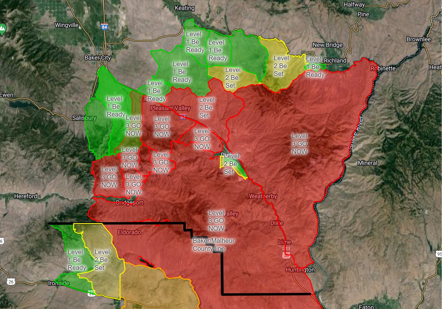
Baker County Evacuation Levels Update 306 pm 07 24 2024
Related Incident: Durkee Fire
Publication Type: Announcement
Additional evacuation levels have been issued for the the following areas:
Level 3 (GO NOW) evacuation has been issued east of Highway 245, south of US Forest Service Road 11 and west of Deer Creek drainage.
Level 3 (GO NOW) evacuation has been issued for northwest of Iron Mountain, southeast of the Pleasant Valley area and south of Pritchard Creek.
Level 3 (GO NOW) evacuation has been issued for the area of Ebell Creek from Old Highway 30 to Beaver Mountain.
Level 2 (BE SET) evacuation has been issued for the area south of Highway 86, east from Fivemile Creek, west of lower Timber Canyon and to the ridgetop.
Level 2 (BE SET) evacuation has been issued for the area south of Love Reservoir Lane, east of Sardine Creek Road, and north of Lawrence Creek.
Level 1 (BE READY) evacuation has been issued for the area west of Fivemile Creek, east of Ruckles Creek and Oregon Trail Road to Quartz Creek, and north of (I-84, the headwaters of Pritchard Creek and Love Reservoir Lane).
Level 1 (BE READY) evacuation has been issued for the area west of Ebell Creek, north of US Forest Service Road 11, east of Highway 245 and Highway 7 and south of I-84.
Please see the updated map in this post.
A severe weather warning has been issued for this afternoon and high winds are causing extreme fire activity. Gusts up to 70mph are forecasted. This continues to be an incredibly dynamic situation.
A temporary evacuation shelter has been established at the Baker City Church of the Nazarene Family Life Center located at 1250 Hughes Lane. For questions about the temporary shelter, please contact the American Red Cross at 1-800-733-2767.