U.S. flag

An official website of the United States government

Here's how you know

Single Incident Information

Zoom to your location
Reset map zoom and position

Could not determine your location.

Microwave Tower Fire

Unit Information

3501 East Third Street 
P.O. Box 670 
Prineville, 
Oregon 
97754 
3501 East Third Street 
P.O. Box 670 
Prineville, 
Oregon 
97754 

Incident Contacts

Microwave Tower Public Information
Email: 2024.microwavetower@firenet.gov
Phone: 541-208-1744

Highlighted Activity

FireCrews continue to construct indirect handlines while helicopters with buckets drop water directly on active fire. Today, clear sky, variable wind, and temperatures in the upper 80s are expected on the Whisky Creek Fire. Heavy smoke from the Williams Mine fire near Mt Adams could impact flight operations. The Whisky Creek Fire is currently 1335 acres.Los equipos continúan construyendo líneas… Read more
Publication Type: News -
For the Whisky Creek, Microwave Tower, and Sandstone Fires, nearby federal lands have been affected, prompting temporary closures. These closures are in place to protect public safety and support firefighting efforts.Conditions are changing rapidly. Smoke and fire conditions pose serious risks to public health and safety. It’s essential to obey all closure orders and avoid affected areas.For the… Read more
Publication Type: Closures -
Size: 1,313 acresStart Date: July 22, 2024Cause: UndeterminedLocation: 5 miles west of Mosier, ORContainment:  89%Fuels: Brush, timber, and grassHighlights:Pockets of vegetation and debris continue to burn within the fire’s perimeter, producing smoke which may be visible while traveling on Interstate 84. Please use caution when venturing along this area. No perimeter… Read more
Publication Type: News -

Highlighted Media

2024 Microwave Tower Fire

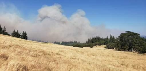
The Microwave Tower Fire was first reported on July 22nd at 1541, burning in grass and timber. Oregon Department of Forestry, the Columbia River Gorge National Scenic Area Forest Service, and local fire districts were first to respond. The fire's point of origin was roughly 5 miles West Southwest of Mosier, OR. Evacuations are in place and can be monitored on the Wasco County Sheriff's Facebook page.  

Smoke reports for the general area (in English and Spanish) can be found at Airnow.gov.

Basic Information
Current as of Wed, 08/07/2024 - 14:56
Incident Time Zone America/Los_Angeles
Incident Type Wildfire
Cause Undetermined
Date of Origin
Location 1 mile WSW of Mosier, OR
Incident Commander Northern Rockies Complex Incident Management Team 2 assumed command of the fire August 4, 2024, at 6 a.m.
Incident Description This is a full suppression fire with brush, timber and grass components.
Coordinates 45° 40' 52'' Latitude
-121° 27'
26
'' Longitude
Current Situation
Total Personnel: 27
Size 1,313 Acres
Percent of Perimeter Contained 89%
Estimated Containment Date 08/10/2024
Fuels Involved

Short Grass (1 foot)

Timber (Litter and Understory)

Significant Events

Stumpholes and heavy fuels continue to smolder along with roll-out, exposing hot spots well within the interior. Smoke is visible from the road. No perimeter growth has been observed. Higher winds and
temperatures observed over the fire during today's shift.


Outlook
Planned Actions

Patrol all divisions of the fire. Patrol and mop up on uncontained fire lines to secure edge. Continue suppression repair. Night operations discontinued.

Projected Incident Activity

Forecasted temperatures and relatively humidity recoveries could contribute to slightly increased fire activity within the interior perimeter of the fire. No growth is expected. Night shift has been dropped, only day shift for the incident.

Current Weather
Weather Concerns

A weak trough moved through the region today which resulted in breezes and cooler temperatures with southwesterly to northwesterly winds of 10 to 15 mph and gusts up to 25 mph. Temperatures were in the upper 60's to 70's with min relative humidity in the upper 20's to upper 30's across the fire area.
Tomorrow, a ridge of high pressure will build over the area where temperatures will start to warm up. Winds will generally be westerly around 10 mph or less with gusts up to 18 mph. Overnight relative humidity will be in the 60's to 70's and then falling to the 30's to low 40's by the late afternoon.