
Homestead Complex Fire Update07 26 2024
Related Incident:
Publication Type: News
HOMESTEAD COMPLEX
Homestead Complex Fire Update Friday, July 26, 2024
Phone: 208-713-9693 (8 a.m. to 8 p.m.)
Email: 2024.homesteadcomplex@firenet.gov
Facebook: www.facebook.com/HomesteadComplexFireInfo
Lost Bucket Fire Now in Patrol and Maintain Status
As of this morning, the seven fires in the Homestead Complex total 1,179 acres. Suppression tactics are being prioritized by threat to property, infrastructure, industry, and areas with the highest probability of success. 306 resources are assigned, including hand crews, engines, water tenders, dozers, feller bunchers and skidgens.
Firefighters completed removing the hoselay on the Lost Bucket Fire (35 acres). The majority of resources from Lost Bucket will now be assisting the Salmon 33 Fire, as well as the No Man Fire. Remaining resources will continue to maintain and patrol the control lines around Lost Bucket.
Last night, a hotshot crew camped out near the Salmon 33 Fire (133 acres) to maximize opportunities to construct fireline during cooler evening and morning conditions, when the fire is less active. On the No Man Fire (350 acres), crews and heavy equipment operators have been making progress constructing fireline. On the east side of No Man Fire, staff are improving existing roads to use as containment line. Great Basin Team 5 is coordinating with cooperators west of the fire to construct indirect control lines.
The Horse Heaven Creek Fire (371 acres) continues to be the most active fire in the complex. Handcrews, engines, and heavy equipment are building direct and indirect containment lines on the north and east sides of the fire.
The Reynolds Butte Fire (104 acres) showed minimal activity yesterday. Crews continue building indirect firelines and laying hose. Firefighters are using information from scouting missions the past few days to develop plans for direct and indirect firelines when resources are available to be assigned to the Fuller Lake Fire (61 acres) and Bullpup Fire (125 acres).
Winds will remain light today, but the temperature is expected to increase slightly. Reduced cloud cover in the morning and lower relative humidity could lead to a moderate increase in fire activity. However, the overall fire activity is expected to remain minimal. Local smoke outlooks can be found online at: https://outlooks.airfire.org/outlook/d393fd74.
Area fire restrictions and danger ratings are as follows: Fire Danger Rating: High. Industrial Fire Precaution Levels (IFPLs): 2. Public Use Fire Restrictions (PURs): 2.
CLOSURES: Umpqua National Forest has issued two closures across the forest in response to fire activity to protect public and wildland firefighter safety. Emergency Fire Closure ORDER NO. 06-15-24-03 and Emergency Fire Closure ORDER NO. 06-15-02-24-01 which impact all of the Cottage Grove Ranger District, most of the Diamond Lake Ranger District, and parts of the Tiller and North Umpqua Ranger Districts. The closure orders can be found here: https://www.fs.usda.gov/alerts/umpqua/alerts-notices.
Miller Peak daily update July 26 2024 07 26 2024
Related Incident:
Publication Type: News
KEY MESSAGE
The fire has seen no increase in acreage. Around the fire area crews have moved into “mop-up” and patrol status. Firefighters are assisting with new fire starts around the area.
CURRENT STATUS
There has been no fire growth or heat detected outside of the lines following the weather event Wednesday night. Crews continue with their “mop-up” operations and patrol, working along the previously constructed handline around the fire’s perimeter. Firefighters are well prepared to respond to any increases in fire activity, and work continues to strengthen existing containment lines. In the southeastern section of the fire, crews have halted progression of the fire with special focus on the values at risk and connecting lines to the Northeast. The I-90 corridor remains a vital value and is the priority for the heavy equipment. Additionally, firefighters and aviation resources have been assisting with new ignitions around the area.
WEATHER AND FIRE BEHAVIOR
Despite the gusty winds and Red Flag conditions, previously constructed firelines held. A westerly upper-level wind flow moved into the region and is expected to remain there over the next several days. This weather pattern will result in more seasonal temperatures for this time of year. Afternoon humidities will continue to drop into the teens each day. The fire location will experience westerly winds each afternoon into the evenings, but gusts on the ridges are not expected to be overly excessive.
CLOSURES
Lower Miller Creek Road is closed from debris due to the storm. A temporary flight restriction is in effect over the fire area. An area and road closure around the fire is in effect due to hazardous conditions resulting from fire activity. Stage II fire restrictions are in effect in the area. Specific closure information and maps are posted on InciWeb at https://inciweb.wildfire.gov/incident-information/mtlnf-miller-peak-fire and https://www.fs.usda.gov/alerts/lolo/alerts-notices as they are implemented.
Ore Fire Update 07 26 2024
Related Incident: Ore Fire
Publication Type: News
Ore Fire Update
Friday, July 26, 2024 – 9:00 a.m.
Size: 1223 acres | Reported Date: July 16, 2024 | Cause: Under Investigation | Containment: 3%
Total Assigned Personnel: 304 | 8 engines | 5 hand crews | 3 dozers | 20 water tenders | 4 masticators | 4 feller bunchers
(Blue River, Ore.) – Fire suppression efforts continue on the Ore Fire, which is burning 7 miles northeast of Blue River, Oregon. Challenges include steep and rugged terrain, rolling rocks and debris and fire-weakened trees. Firefighter and public safety remain the number one priority on the incident. Fire managers are focusing on activities with a high probability of success while minimizing risk to firefighters and protecting values such as communities, infrastructure and forest, recreation and cultural resources. To the north, fire managers are continuing to evaluate placement of control lines to further reduce the amount of landscape that will be affected by the fire. Despite increased fire activity and growth in the southern portion, crews are containing the fire along roadways to protect critical values.
Yesterday, the line was tested by the burning debris and logs rolling onto FS 1509 Road near Ore Creek. Heavy equipment operators cleared these roadways, allowing crews to quickly resume their work. Firefighters installed pumps, hose lays and sprinklers to pre-treat the unburned side of the road, raising the overall humidity and resulting in fuels being less receptive to fire.
Today, firefighters are extending plumbing along FS 1509 Road northwest of Ore Creek. Dozers arebeing utilized to connect the FS 15 Road to the FS 501 Road. Vegetation removal will begin north of the fire on FS Road 1513, and crews will chip the woody debris into finer, more manageable material, returning it to the forest floor.
The H.J. Andrews Experimental Forest near Blue River is one of the significant values at risk identified by the Willamette National Forest. This area holds important cultural and scientific value, as it has been the site of long-term research on climate, streamflow, water quality, vegetation succession, biogeochemical cycling, and the effects of forest management for almost 70 years. Firefighters are holding the fire north of FS 15 Road to protect this forest, its timeless resources and other values at risk from the Ore Fire. To learn more, visit the Ore Fire Facebook page: www.facebook.com/orefireinformation2024.
Weather: A northerly flow will bring warmer and drier conditions this afternoon with light, terrain-driven winds. Temperatures will be near normal. A passing cold front Monday into Tuesday will bring a chance of rain.
Safety: While the Ore Fire is not threatening homes, wildfire season is just beginning. Sign-up now to receive critical alerts about wildfires and other emergencies at https://www.lanecounty.org/sign_up_for_notifications. Fire restrictions are in place within the Willamette National Forest. For more information, visit https://www.fs.usda.gov/main/willamette/fire. A Temporary Flight Restriction (TFR) is in place over the fire area. Unstaffed Aerial Systems (UAS or drones) are also prohibited within the TFR. If you fly, we can’t.
Smoke: Smoke from numerous wildfires burning throughout the region will affect air quality in many areas over the coming days. A daily smoke outlook can be found at https://wildlandfiresmoke.net. Being prepared for smoke is important to everyone’s health. For more information, go to: www.airnow.gov/wildfires/be-smoke-ready.org/
Forest Closures: Closures in the Willamette National Forest have been established around fire-impacted areas. These closures include the following sites: Buck Mountain Trail, Tidbits South and West Trail, Gold Hill Trail, Mona Campground, Lookout Campground, and Saddle Dam Boat Launch. For a complete list of recreation and roads in the Ore Fire closure order, visit https://www.fs.usda.gov/alerts/willamette/alerts-notices.
Shelly Fire Morning Update 07 26 2024
Related Incident: Shelly Fire
Publication Type: News
Location: Siskiyou County, CA Start Date: Wednesday July 3, 2024 at 1:27 PM
Size:15,477 acres Percent Contained:89%
Cause: Under Investigation Personnel:1,233
CURRENT SITUATION:
The priority at the Shelly Fire is now suppression repair.
The fire perimeter has held during recent strong winds. Firefighters continue working toward full containment.
Resources are being released to support new incidents. Those that remain focus on timely repair and clean up of the areas utilized during suppression efforts.
Drivers should continue to remain alert for fire personnel and heavy equipment on or near the roadways.
WEATHER:
Today will have low relative humidity, high temperatures, and winds from the southwest, reaching up to 28 miles per hour on ridges.
EVACUATIONS:
For current evacuation status, visit www.facebook.com/SiskiyouCountySheriff and www.facebook.com/SiskiyouCountyOES. Additional evacuation information and a map can be found on the Genasys site at https://protect.genasys.com/search?z=14&latlon=41.550694%2C-122.905589.
CLOSURES:
An official forest closure around the Shelly Fire went into effect on July 4th and at this time has been reduced in size. Hikers are not permitted and will be asked to leave the area. For details and a map of the closure area, please visit https://www.fs.usda.gov/Internet/FSE_DOCUMENTS/fseprd1187463.pdf.
FIRE RESTRICTIONS:
Forest fire restrictions are currently in effect. Campfires and stove fires are restricted to those developed areas listed in the forest order at https://www.fs.usda.gov/alerts/klamath/alerts-notices/?aid=88596. Smoking, welding, and operating an internal combustion engine also have restrictions in place.
Pacific Crest Trail Information: https://www.pcta.org/discover-the-trail/closures
2024 SQF Lightning Smoke Outlook 07 26 2024
Related Incident: 2024 SQF Lightning
Publication Type: News
Special Statement
A Red Flag Warning is in affect until 2300 on 7/27. The Borel Fire was added to the Outlook.
Fire
Yesterday, westerly winds increased interior activity on the Trout Fire near Boone Meadow and in the Little Trout/Snow creek drainages. The Borel Fire was very active in the Mill Creek drainage. Tactical firing operations are possible today on the western side of the Trout Fire and significant eastern spread is possible on the Borel Fire. Expected fire behavior includes smoldering, single tree/small group torching, spotting, and potential uphill runs. Additional information can be found here SQF Lightning Fires Inciweb
Smoke
Yesterday, smoke transport was influenced by an increase in westerly winds and tracked to the east/northeast. Today, the dry westerly flow will increase, and smoke transport will again be generally to the east/northeast. Western foothill communities will see generally cleaner air with GOOD to MODERATE conditions expected. The north Owens Valley should see generally GOOD conditions with smoke staying to their south. The southern Owens Valley can expect MODERATE conditions during the day with the potential pockets of USG overnight as smoke settles. Westerly winds will continue into Saturday. Overnight smoke pooling from the Borel Fire is possible in Walker Basin tonight.
Hill Fire Morning Update 07 26 2024
Related Incident: Hill Fire
Publication Type: News
HILL FIRE INCIDENT UPDATE
Date: July 26, 2024
Fire Information: 530-414-9056
Hours: 08:00 AM to 8:00 PM
Email:2024.Hill@firenet.gov
Incident Website:
https://inciweb.wildfire.gov/incident-information/casrf-hill-fire
https://www.fire.ca.gov/incidents/2024/7/16/hill-fire
Location: Humboldt County, CA
Size: 7111 acres
Cause: Under Investigation
Start Date: Monday July 15, 2023, at 5:40 PM
Percent contained: 17%
Personnel: 1699
CURRENT SITUATION:
The number one priority for firefighters is the Sugarloaf Mountain area, and crews are working around the clock to the keep the fire within established dozer and handlines.
With the increased humidity and lower temperatures, tactical firing was done yesterday and through the evening, supported by aircraft. This strategy aimed to gradually move the fire down Sugarloaf Mountain toward Forest Road 5N14. This road extends north and connects with a dozer line that ties back to 6N06 Road, creating a perimeter around the fire. These operations have been successful and are ongoing. Activities have been slow and methodical as the steep terrain presents safety issues for the crews. Fire-burned trees, loose soil, and dislodged rocks call for extra awareness.
Control lines in the north, west, and south are holding firm, with crews actively mopping up and patrolling these areas. They will also focus on removing hazardous trees and those threatening the containment lines.
Contingency line construction continues to the south and along the Hennessy Ridge in the east. The Structure Defense Group has worked with local agencies to evaluate residences, roadways, and other values at risk.
WEATHER:
Today, conditions will get better with more marine influence. The inversion layer will help humidity levels go up, reaching mostly above 30 percent during the day. Temperatures will also drop, staying mostly below 80 degrees. Winds will be mostly influenced by the terrain, blowing from the northwest at higher elevations in the afternoon.
EVACUATIONS:
Humbolt County: Evacuation order and warnings remain in effect. For current updates on evacuations, visit https://www.facebook.com/HumboldtSheriff and https://humboldtgov.org/2383/Current-Emergencies.
Trinity County: Evacuation warnings remain in effect. For current updates on evacuations, visit https://www.facebook.com/profile.php?id=100064589806351 and https://www.trinitycounty.org/OES
Conditions are subject to change at any time, visit https://protect.genasys.com/search for a full zone description.
Sign up for Humboldt Alert emergency notifications at https://humboldtgov.org/2014/Emergency-Notifications
CLOSURES:
Forest Closure Order currently in effect for the area impacted by the Hill Fire. It is temporarily prohibited to be on any national forest system land, trail, or road within the closure area. To view the closure order and map of closure area visit the following link www.fs.usda.gov/Internet/FSE_DOCUMENTS/fseprd1191963.pdf.
Road closures are currently in place on Friday Ridge Rd. at Forest Service Route 6N06, Friday Ridge Rd. at Forest Route 5N01 and Friday Fridge Rd. at Forest Route 5N04. For updated road closure information, visit protect.genasys.com or humboldtsheriff.org/emergency.
FIRE RESTRICTIONS:
Forest fire restrictions also went into effect on July 12th. Campfires and stove fires are restricted to those developed areas listed in the forest order located at https://www.fs.usda.gov/Internet/FSE_DOCUMENTS/fseprd1188610.pdf.
Smoking, welding, and operating an internal combustion engine also have restrictions in place.
Borel Fire Kern County Evacuation Order Zone KRN738 07 26 2024
Related Incident: 2024 SQF Lightning
Publication Type: Announcement
This is a message from the Kern County Fire Department
Haga clic aqui para Espanol: https://ahas1.com?es5494
For ASL interpretation follow the link: https://ahas1.com?5494
This is an update for the Borel Fire in the Havilah area. Zone(s) KRN-738 has been upgraded to an Evacuation Order. You should Leave NOW. Visibility in the area will be reduced and roads may become blocked; if you do not leave now, you could be trapped, injured or killed.
If you have physical limitations and require evacuation assistance, please call the Aging & Adult Services hotline at 1-855-264-6565.
**Please plan to use Caliente Bodfish Rd SOUTH to the Tehachapi Area when evacuating the area. Evacuees are advised not to access Caliente Creek Rd**
An evacuation center has been set up at:
Tehachapi Education Center
126 S. Snyder Ave.
Tehachapi, CA 93561
Animal Services will assist with sheltering companion animals at the center.
Evacuation Boundaries:
North of: Stagecoach Dr.
South of: Pine St.
East of: Foxtail Canyon Rd.
West of: Red Mountain
Affected Genasys Protect zone(s) KRN-738
Follow the link to view a map of the area under the Evacuation Order:
For the most updated information, please continue to monitor local media or visit Facebook.com/ReadyKern
If you have an emergency, call 9-1-1
Retreat Fire Closure 08 01 2024
Related Incident: Retreat
Publication Type: Closures
UNITED STATES DEPARTMENT OF AGRICULTURE
Forest Service
Okanogan-Wenatchee National Forest Naches, WA
Retreat Fire Closure Closure Order: 06-17-08-24-17
Pursuant to 16 USC § 551 and 36 CFR § 261.50(a) and (b), and to provide for public safety, the following acts are prohibited within the Naches Ranger District of the Okanogan-Wenatchee National Forest. This Order supersedes Order 06-17-08-24-17, dated July 24, 2024, signed by Acting Forest Supervisor Tara Umphries. This Order is effective July 30, 2024, through October 31, 2024, unless rescinded sooner.
PROHIBITIONS:
Entering into or being upon National Forest System lands, as described below and displayed on the attached map, Exhibit A [36 CFR § 261.53(e)].
Being on a National Forest System trail, as described below and displayed on the attached map, Exhibit A [36 CFR § 261.55(a)].
Being on a National Forest System Road as described below and displayed on the attached map, Exhibit A [36 CFR § 261.54(e)].
Use of vehicle off of National Forest System Roads as described below and displayed on the attached map, Exhibit A [36 CFR § 261.56].
CLOSURE AREA DESCRIPTION:
The Retreat Fire Area Closure is defined as follows:
The closure area boundary begins at the junction of the Forest Boundary at Hwy. 12 East and extends to the North and South from that intersection to the west, and is described as T14N R15E, extending North to section 1 and to the South to section 36. To the south the closure extends to the West following the Forest Boundary in T13N R14E and ending at the southwest corner of section 29. The closure will extend north from this corner, following the boundary line for T13N R14E, to its intersection with FSR 1203 at sections 16 and 17, and includes all lands to the east of this boundary. The closure then extends north following FSR 1203 to its intersection with FSR 1200- Tieton Rd. and is described as T14N R14E, section 28. The closure extends east on Hwy 12 to the junction of FSR 1500- Bethel Ridge Rd., following FSR 1500 to the northwest to its junction with FSR 1500-0324, described as T14N R14E, section 7. The boundary then extends to the east following FSR 1500-0324 until it intersects with FSR 1500- 0325A, it then goes east along FSR 1500-325A, towards the junction with FSR 1400- Oak Creek. The boundary then is composed of the north, east, and south boundary lines of T14N R15E.
FSR 1500-Bethel Ridge Rd. from Hwy. 410 to its junction with FSR 1500-0324 will remain open. FSR 1200 Tieton Rd, from its western entrance to the closure at FSR 1203 will remain open.
The following campgrounds, roads and trails are included in this closure order:
Developed Campgrounds Closed
- Windy Point Campground
- Willows Campground
- Hause Creek Campground
- Wild Rose Day Use Area
- Tieton Pond Campground
- Peninsula Campground
- South Fork Bay Campground
Roads Closed
- FSR 580
- FSR 606
- FSR 1202
- FSR 1203
- FSR 1500-0312
- FSR 1500-0313
- FSR 1304 and all spurs and intersecting roads.
- FSR 1500-325A in its entirety.
- FSR 1201 and all spurs and intersecting roads.
- FSR 1301
- FSR 1302 and all spurs and intersecting roads.
- FSR 1304 and all spurs and intersecting roads.
- FSR 1400 and all spurs and intersecting roads.
- FSR 1401 and all spurs and intersecting roads.
- FSR 1410 and all spurs and intersecting roads
- FSR 1500 from the junction with US Highway 12 up to the junction with FSR 1500-0324
- FSR 1200 (Tieton Rd) from the eastern junction with US Highway 12 to the junction with FSR 1203
Motorized Trails Closed
- Trail No. 1126- Louie Trail
- Trail No. 1127- Divide Ridge Trail
- Trail No. 1202
- Trail No. 1146
- Trail No. 1145- Long Lake
- Trail No. 224
- Trail No. 232
- Trail No. 237
- Trail No. 262
- Trail No. 602 – Sleepy Loop Trail
- Trail No. 608
- Trail No. 608A- Long Lake Tie
- Trail No. 609- Pickle Prairie Trail
- Trail No. 609A- Pickle Prairie Loop Trail
- Trail No. 610
- Trail No. 613- Divide Ridge East Trail
- Trail No. 652- Bethel-Oak Trail
- Trail No. 671- Bethel – Lynn Tie Trail
- Trail No. 672- Bethel Trail
See Exhibit A for closure map.
EXEMPTIONS:
Pursuant to 36 CFR § 261.50(e), the following persons are exempt from this Order:
- Any Federal, State, or local officer, or member of an organized rescue or fire-fighting force in the performance of an official duty.
- Persons with Forest Service Permit No. FS-7700-48 (Permit for Use of Roads, Trails, or Areas Restricted by Regulation Order), specifically exempting them from this Order.
These prohibitions are in addition to the general prohibitions in 36 CFR Part 261, Subpart A.
Violations of these prohibitions are punishable by a fine of not more than $5,000.00 for an individual or $10,000.00 for a corporation, or imprisonment for not more than six months, or both. (16 USC § 551; 18 USC §§ 3551, 3559, 3571, and 3581.)
Executed in Wenatchee, Washington this 30 day of July 2024
TARA UMPHRIES
Digitally signed by TARA UMPHRIES Date: 2024.07.30 10:07:20 -07'00'
TARA UMPHRIES
Acting Forest Supervisor
Okanogan-Wenatchee National Forest
A violation of these prohibitions is punishable by a fine of not more than $5,000 for an individual or $10,000 for an organization, or imprisonment for not more than 6 months, or both. 16 USC § 551 and 18 USC §§ 3559, 3571, and 3581.
Silver King Fire Daily Update July 26 2024 07 26 2024
Related Incident: Silver King Fire
Publication Type: News
Public Information Phone: (435) 310-5450 Email: 2024.silverking@firenet.gov
Agency: Fishlake National Forest – Beaver Ranger District
Location: Approximately three miles west of Marysvale, Utah
Start Date: July 05, 2024
Cause: Lightning
Acres: 18,222
Containment/Completion: 86%
Personnel: 258
Beginning today moisture will move out of the area, leading to a warming and drying trend with a high likelihood of Red Flag Warnings this weekend. Not only will the Silver King Fire containment lines be tested, but other potential lightning fires could pop up and require initial attack. Use extra caution while these conditions exist to avoid starting a new fire; this would strain already-depleted fire resources. Abide by Stage 1 Fire Restrictions that prohibit any open fire EXCEPT when located at an approved facility or campground.
If you plan to be outdoors over the next few days, keep sun and heat safety in mind. Between 2004 and 2018 there were an average of 702 heat-related deaths per year in the United States. Heat stress cases are very common in the summer and can progress rapidly to heat exhaustion and heat stroke, which is a dangerous and life-threatening illness. We often are having so much fun outside that we forget about this very real danger. Follow these 3 simple rules to keep you safe from the summer heat.
Rehydrate Always keep water with you and remember to drink it throughout the day. Staying hydrated allows your body to regulate its temperature.
Shade up Locate cool and shady areas to rest in regularly. There can be a 10- to 15-degree temperature difference between the sun and shade.
Recognize Heat Stress Early recognition of the signs of heat stress will help you prevent deterioration into heat exhaustion and heat stroke. Signs of heat stress are heat rashes, dizziness, disorientation, lack of sweating, and cramps.
Suppression and repair remain the focus for firefighters on the Silver King. On the north side of the fire, crews continue to patrol and monitor the perimeter. On the east side, personnel continue dozer line repair. On the south and west sides, firefighters continue to monitor and secure edges where possible.
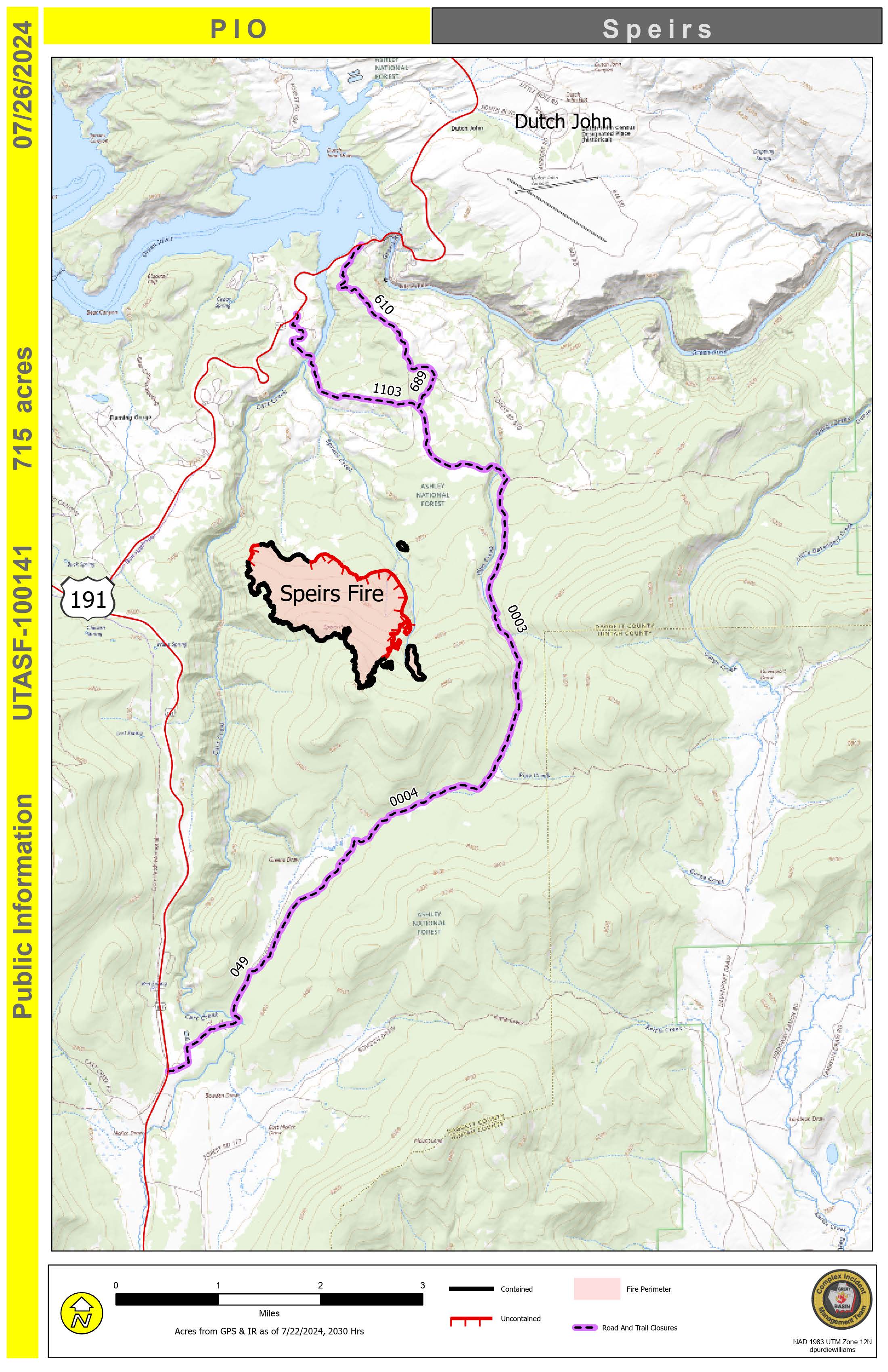
Speirs Fire Daily Update every other day 07 26 2024
Related Incident: Speirs Fire
Publication Type: News
The Speirs Fire daily fact sheet will be moving to an every other day posting (next one will be shared tomorrow morning) but here are some quick facts for today:
715 acres, 68% contained, 399 personnel & please watch the operational update video that has been posted on the Ashley National Forest FB page.
If you have specific questions, please contact the Speirs Fire information line at (435) 709-8209.